

Mori Atlas logo
National parkTalang Satang National Park

Map your exploration of this national park's geographic boundaries and natural terrain.

Talang Satang National Park: Protected Landscape and Regional Geography in Sarawak

(Taman Negara Talang Satang)

Talang Satang National Park represents a distinct protected landscape within the diverse geography of Sarawak, Malaysia. As a national park, it offers a focal point for understanding regional natural features and mapped conservation areas on Borneo. This page provides detailed geographic context, aiding in the atlas-style exploration of its protected boundaries and the surrounding natural terrain.

Marine Protected AreaTurtle Nesting SiteCoral ReefsSarawakIsland ParkEndangered Species Conservation

Talang Satang National Park

National park

Park overview

Structured park overview, official facts, and landscape profile for Talang Satang National Park

Talang Satang National Park park facts, protected area profile, and essential visitor context
Review the core facts for Talang Satang National Park, including designation, size, terrain, visitor scale, habitats, and operating context in one park-focused overview.

About Talang Satang National Park

Talang Satang National Park represents a cornerstone of marine conservation in Sarawak, Malaysia, established in September 1999 as the state's inaugural marine protected area. The park encompasses four islands and their adjoining waters, spanning 19,414 hectares of coastal and marine habitat off the Sarawak mainland. These islands, known collectively as the Turtle Islands, are situated near the Santubong peninsula with Satang Besar accessible by a 30-minute boat ride from Damai Beach or Telaga Air Jetty.

The park's ecological significance derives from its role as a critical nesting and feeding habitat for endangered marine turtles. Both hawksbill and green turtles nest on the island beaches in significant numbers, representing the highest concentration of nesting activity in Sarawak. The surrounding shallow coral reefs provide essential refuge areas for turtles and numerous other marine species throughout their life cycles. Beyond turtles, the marine environment supports hard and soft coral communities, seagrass beds, and diverse invertebrate populations that contribute to the overall biodiversity of the area.

Conservation management within the park takes a comprehensive approach, addressing both the terrestrial nesting beaches and the broader marine ecosystem. The Sarawak Forestry Corporation oversees monitoring programs, research activities, and visitor management. Key conservation initiatives include turtle hatchery operations on Satang Besar Island, annual reef cleaning exercises, continuous water quality monitoring, and collaborative studies with local universities. The placement of reef balls at Talang-Talang Besar Island represents an innovative approach to habitat restoration and coral protection.

Quick facts and research context for Talang Satang National Park

Talang Satang National Park occupies 19,414 hectares along the coast of Sarawak, Malaysia, established in September 1999 as the state's first marine conservation area. The park comprises four islands: Talang-Talang Besar and Talang-Talang Kecil near Sematan, and Satang Besar and Satang Kecil near Santubong. These islands collectively form Sarawak's Turtle Islands, supporting the region's highest concentration of nesting hawksbill and green turtles, both listed as endangered. The surrounding waters contain shallow coral reefs that function as critical habitat for marine species. The park is managed by the Sarawak Forestry Corporation, which conducts conservation programs including turtle hatchery operations, reef monitoring, and habitat restoration activities.

Park context

Deeper park guide and search-rich context for Talang Satang National Park

Talang Satang National Park history, landscape, wildlife, and travel context
Explore Talang Satang National Park through its history, landscape character, ecosystems, wildlife, conservation priorities, cultural context, and seasonal travel timing in a structured park guide built for atlas discovery and search intent.

Why Talang Satang National Park stands out

Talang Satang National Park is best known as the primary nesting ground for endangered hawksbill and green turtles in Sarawak. The islands support the highest population of nesting sea turtles in the state, with five species documented nesting between April and September annually. The Satang Besar Island hosts a turtle hatchery and conservation program operating under strict access controls to protect breeding populations. The surrounding coral reef systems, particularly around Talang-Talang Island, represent some of the largest protected coral reefs in Sarawak, supporting both turtle populations and diverse marine biodiversity. The park's designation as Sarawak's first marine protected area underscores its foundational role in the state's coastal conservation strategy.

Talang Satang National Park history and protected-area timeline

The establishment of Talang Satang National Park in September 1999 marked a pivotal moment in Sarawak's environmental conservation history as the state's first designated marine protected area. The creation of the park addressed the need for formal protection of Sarawak's Turtle Islands, which had faced mounting pressures from development, habitat degradation, and historical harvesting of turtle eggs and adults. Gazettement enabled conservation efforts to extend beyond individual nesting beaches to encompass the entire marine ecosystem supporting turtle populations.

Turtle conservation at the park involves addressing both historical challenges and legal complexities that have shaped management approaches. The park's protected status enables conservation work across the full marine range of turtles, not merely at nesting sites. Conservation programs have evolved to incorporate scientific monitoring, community engagement, and collaborative research partnerships with academic institutions. The development of the turtle hatchery and conservation program on Satang Besar Island represents a targeted response to protection needs, operating under controlled access protocols to minimize disturbance to nesting activities.

Talang Satang National Park landscape and geographic character

The physical landscape of Talang Satang National Park centers on four islands with contrasting coastal environments. The islands feature extensive sandy beaches along wave-exposed shores, particularly on Satang Besar and the Talang-Talang Islands, where turtle nesting activity concentrates. These sandy coastlines support burrowing invertebrates and other organisms adapted to dynamic coastal conditions. Rocky outcrops line portions of the island shores, creating tidal zone habitats with distinct zonation patterns for marine organisms.

The surrounding marine environment is characterized by shallow coral reefs encircling the islands, forming a continuous reef system that serves as critical habitat for marine species. Water depths average around 10 meters with consistent temperatures of approximately 30°C, supporting coral growth and diverse reef communities. The islands are situated relatively close to the Sarawak mainland coast near the Santubong area, positioning them within a broader coastal landscape that includes river systems like the Kayan and Sematan Rivers, whose runoff influences water quality and sediment conditions in the surrounding marine environment.

Talang Satang National Park ecosystems, habitats, and plant life

The ecological character of Talang Satang National Park is defined by its coral reef ecosystems and associated marine habitats. Talang-Talang Island stands out as one of the largest protected coral reef areas in Sarawak, containing both hard and soft coral communities. The reef systems function as essential feeding, breeding, and refuge areas for numerous marine species, creating a biodiverse underwater environment despite facing environmental pressures.

Seagrass beds also occur within the park, particularly around Talang-Talang Island, contributing to habitat complexity and supporting additional marine species. While seagrass diversity in this area is lower compared to other locations in Sarawak, the presence of these habitats adds to the overall ecological value of the protected area. The combination of coral reefs, seagrass beds, and sandy beach environments creates a mosaic of marine habitats that support different species at various life stages, from juvenile nursery areas to adult feeding grounds.

Talang Satang National Park wildlife and species highlights

The wildlife of Talang Satang National Park is most notably represented by sea turtles, with five species documented nesting on the islands between April and September each year. The green turtle (Chelonia mydas) and hawksbill turtle (Eretmochelys imbricata) represent the most significant nesting populations, with the park supporting Sarawak's highest concentration of these endangered species. Additional nesting species include the Olive Ridley, Leatherback, and Loggerhead turtles, though in smaller numbers.

Beyond turtles, the coral reef communities host diverse fish species, invertebrates, and other marine organisms that depend on reef habitats. The intertidal zones along rocky shores support specialized invertebrate communities adapted to tidal fluctuations. The marine ecosystem as a whole provides feeding and nursery functions for various species, contributing to regional marine biodiversity. While specific species counts or detailed faunal inventories are not extensively documented in available sources, the reef and associated habitats clearly support substantial marine life beyond the flagship turtle populations.

Talang Satang National Park conservation status and protection priorities

Talang Satang National Park serves as a critical conservation hub for Sarawak's marine biodiversity, with particular emphasis on protecting endangered sea turtle populations and their habitats. The park's designation as a protected area enables management of both nesting beach environments and the surrounding marine ecosystem, taking a comprehensive approach to species conservation. The turtle hatchery program on Satang Besar Island represents an active intervention to support nesting success and juvenile survival.

The park faces ongoing environmental challenges, most notably from sedimentation impacts on coral reefs originating from river runoff in the surrounding coastal area. Sediment deposition from the Kayan and Sematan Rivers has covered portions of the reef system and promoted macroalgae growth, affecting coral health and natural regeneration capacity. In response, conservation activities include annual reef cleaning exercises involving volunteers and government agencies, continuous water quality monitoring, and collaborative research with academic institutions. Reef ball placement at Talang-Talang Besar Island provides additional structural habitat for coral colonization. These efforts aim to maintain and improve the ecological condition of the park's marine environments despite regional environmental pressures.

Talang Satang National Park cultural meaning and human context

The cultural context of Talang Satang National Park relates primarily to its identity as Sarawak's Turtle Islands, a designation reflecting the long-standing significance of these islands for local communities and marine wildlife. The islands are situated within the traditional maritime territory of Sarawak, with access routes from coastal communities including those near Santubong and Sematan. The turtle nesting tradition has historical roots in the region, though conservation measures now regulate human interaction with nesting sites.

The park's management acknowledges the importance of balancing conservation with limited sustainable use, particularly through organized eco-tourism activities that allow visitors to experience the islands' natural values while minimizing impacts. Access to certain areas, particularly the Satang Besar turtle hatchery zone, is restricted to researchers, students, conservation organizations, and monitored tour groups, ensuring that disturbance to sensitive nesting areas remains minimal. This approach reflects both the ecological sensitivity of the area and the need to maintain meaningful connections between local communities and the marine environment.

Top sights and standout views in Talang Satang National Park

Talang Satang National Park's highlights include its status as Sarawak's first marine protected area and the state's most important turtle nesting ground, hosting endangered hawksbill and green turtles. The four-island park features coral reefs recognized among the largest protected reef systems in Sarawak, with the Satang Besar Island turtle hatchery representing a key conservation facility. The park offers scenic island landscapes with sandy beaches, rocky shores, and clear tropical waters suitable for eco-tourism activities. Annual reef cleaning programs and innovative habitat restoration through reef ball placement demonstrate active management engagement. The 2011 recognition of Talang Talang Besar Island among Malaysia's top 10 islands by the Department of Environment underscores its conservation and scenic value.

Best time to visit Talang Satang National Park

The optimal time to visit Talang Satang National Park aligns with the turtle nesting season, which runs from April to September each year. During this period, visitors have the best opportunity to observe nesting activity and, in some cases, witness turtle hatching events. The tropical climate means that conditions remain warm throughout the year, with water temperatures around 30°C suitable for swimming and snorkeling around the coral reefs. However, visitors should be aware that access to certain sensitive areas, particularly the turtle nesting beaches and hatchery zones, remains restricted to protect the endangered species. Eco-tourism activities are generally available outside peak nesting periods, though the park's appeal exists year-round for those interested in marine environments and island landscapes.

Park location guide

Geography guide, regional context, and park location map for Talang Satang National Park

Talang Satang National Park park geography, regions, and map view in Malaysia
Understand where Talang Satang National Park sits in Malaysia through a broader geographic reading of the surrounding landscape, nearby location context, and its mapped position within the national park landscape.

How Talang Satang National Park fits into Malaysia

Malaysia is a federal constitutional monarchy located in Southeast Asia. The country consists of 13 states and three federal territories, divided by the South China Sea into Peninsular Malaysia on the Indochinese Peninsula and East Malaysia on the island of Borneo. With a population of over 34 million, it achieved independence from Britain in 1957 and became a modern federation in 1963. The country is recognized for its multicultural population, tropical climate, and significant economic role in the region.

Wider geography shaping Talang Satang National Park in Malaysia

Malaysia occupies a strategic position in Southeast Asia, split by the South China Sea into two distinct regions. Peninsular Malaysia lies on the Indochinese Peninsula, sharing a land border with Thailand to the north and maritime borders with Singapore, Vietnam, and Indonesia. East Malaysia occupies the northern portion of Borneo, sharing land borders with Brunei and Indonesia, and maritime borders with the Philippines and Vietnam. The country's terrain includes coastal plains, mountain ranges such as the Titiwangsa in the peninsula, and extensive tropical rainforests.

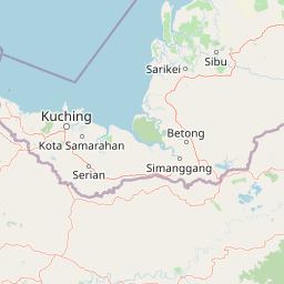
Map view of Talang Satang National Park

Use this park location map to pinpoint Talang Satang National Park in Malaysia, understand its exact geographic position, and read its mapped placement within the surrounding landscape more clearly.

Pigeon | © OpenStreetMap contributors

Location context for Talang Satang National Park

Sarawak
Park atlas

Discover the broader geographic context of Sarawak's coastal conservation landscapes and island ecosystems.

Explore Nearby Protected Areas and Marine Parks: A Continuation from Talang Satang National Park
Continue your exploration of Malaysia's protected marine environments by tracing national parks and conservation areas adjacent to Talang Satang National Park. Compare the regional spread of island habitats, coral reefs, and critical turtle nesting sites to understand Sarawak's full protected-area network.
National parkSarawak

Kuching Wetlands National Park: Sarawak's Protected National Park Landscape and Geography

Explore the mapped wetland boundaries and regional context.

Gain a structured understanding of Kuching Wetlands National Park, a key protected area in Sarawak, Malaysia. This detailed entry provides insights into its specific geographic identity, mapped park boundaries, and its significance as a national park within the Borneo region's extensive natural landscapes. Discover the atlas value of this protected wetland environment for comprehensive geographic exploration.

Area
84.95 km²
Established
1992
IUCN
II
Relief
Lowland
National parkSarawak

Santubong National Park: Sarawak's Protected Landscape for Geographic Atlas Exploration

Mapped park boundaries and regional terrain context in Borneo

Delve into Santubong National Park, a significant protected area situated within the diverse geography of Sarawak, Malaysia. This resource provides detailed information on the park's mapped boundaries, allowing for focused exploration of its specific terrain and its role within the regional protected landscape atlas. Understand the geographic identity of Santubong National Park and its contribution to Borneo's conservation mapping.

Area
14.1 km²
Established
2007
IUCN
II
Relief
Mountain
National parkSarawak

Kubah National Park: National Park Status and Mapped Landscape in Sarawak

Explore its protected boundaries and geographic context within Borneo.

Kubah National Park is a protected national park located in Sarawak, Malaysia, representing a crucial element of the region's conservation landscape. This detailed entry focuses on its identity as a national park, its specific geographic placement within Sarawak, and its significance for map-based exploration. Users can investigate the mapped boundaries and understand how Kubah National Park fits into the larger atlas of protected areas in East Malaysia, providing a factual foundation for geographic discovery without travel advice.

Area
22.3 km²
Established
1989
IUCN
II
Visitors
45K annual
Watercolor illustration of a coastal landscape with a distinctive rock formation, green vegetation, and calm water under a soft sky with distant mountains
National parkKuching Division

Bako National Park: Sarawak's Oldest National Park and Coastal Protected Landscape

Explore diverse ecosystems and dramatic mapped geology near Kuching Division.

Bako National Park, the oldest national park in Sarawak, Malaysia, offers a profound study in ecological concentration and geological drama. Covering a mere 27 square kilometers on the Muara Tebas peninsula, it encapsulates seven distinct ecosystem types, from coastal heath forest to mangrove areas, supporting significant biodiversity. The park's protected landscape is defined by its stunning sandstone coastline, carved by the sea into cliffs, arches, and seastacks, providing a unique geographic context. This makes Bako an essential destination for understanding Borneo's environmental diversity and the mapped boundaries of its conservation areas.

Area
27.27 km²
Established
1957
IUCN
II
Relief
Mixed relief
National parkSarawak

Gunung Gading National Park: Sarawak's Protected Landscape and Geographic Context

Discover mapped terrain and protected area boundaries.

Gunung Gading National Park is an important national park located in Sarawak, Malaysia, offering critical insights into the region's geography and protected lands. This park serves as a key entity for exploring its specific mapped terrain and understanding its place within the diverse landscapes of Borneo. Examining Gunung Gading National Park aids in comprehending the distribution and character of protected areas in East Malaysia through a structured, atlas-oriented approach.

Area
43.6 km²
Established
1983
IUCN
II
Relief
Mountain
National parkKuching Division

Tanjung Datu National Park: Protected Landscape and Regional Geography

Explore its mapped boundaries within Kuching Division.

Tanjung Datu National Park is a protected natural area offering insight into regional conservation and geographic patterns within Malaysia. This entry provides a detailed look at the park's identity as a national park, focusing on its mapped boundaries and its contribution to the broader landscape context of the Kuching Division. It is designed for users seeking structured information about protected areas and their geographical distribution.

Area
7.3 km²
Established
1994
IUCN
II
Climate
Tropical
National parkMalaysia

Maludam National Park: Southeast Asian Protected Landscape and National Park Geography

Mapped boundaries and natural terrain in Malaysia.

Maludam National Park offers a focused exploration of protected landscape identity and geographic context within Malaysia. As a designated national park, it serves as a vital component for understanding the distribution of protected areas and their mapped terrain. This detailed entry allows for an appreciation of the park's specific environmental character and its contribution to the broader atlas of natural landscapes in Southeast Asia, facilitating structured discovery for researchers and explorers.

Area
432 km²
Established
2000
IUCN
II
Relief
Lowland
National parkSarawak

Rajang Mangroves National Park: Borneo's Premier Mangrove Protected Landscape

Explore the mapped geography and wetland conservation of this Sarawak national park.

Rajang Mangroves National Park is a significant protected area dedicated to preserving the intricate mangrove swamp ecosystems of Sarawak's Rajang River delta. Encompassing a vast expanse of tidal channels and riverine forests, this national park serves as a critical habitat for unique wildlife and plays a vital role in coastal ecological health. Its landscape is defined by the dynamic interface between riverine and marine environments, offering a prime example of wetland conservation within Borneo's broader natural geography and atlas context.

Area
107 km²
Established
2000
IUCN
II
Relief
Lowland

Common questions about visiting, size, designation, and location context for Talang Satang National Park

Talang Satang National Park FAQs for park facts, access, geography, and protected area context
Find quick answers about Talang Satang National Park, including protected-area facts, park geography, trail and visitor context, and how the park fits into its surrounding country and regional landscape.
MoriAtlas Explorer

Continue Your Protected Areas Search Across the Global Atlas

Deepen your exploration by continuing the structured search for national parks and protected areas worldwide. Utilize the comprehensive filtering capabilities to compare different conservation landscapes and refine your understanding of global park geography. Discover more about the distribution and characteristics of protected natural areas.

Global natural geography