Mori Atlas logo
National parkTamá National Natural Park

Detailed mapped boundaries and regional geography for this significant national park.

Tamá National Natural Park: Colombia's Protected Landscape Atlas & Geographic Context

(Parque Nacional Natural Tamá)

Tamá National Natural Park represents a vital protected area within the Norte de Santander region of Colombia. As a designated national park, it offers a unique geographic focus for understanding Colombia's protected natural landscapes. This entry provides essential context for atlas-based exploration, detailing the park's mapped presence and its contribution to the regional geography, allowing for a deeper appreciation of its natural landscape and protected status.

Andean mountainsPáramo ecosystemHigh waterfallTransboundary protected areaTropical rainforestAndean forest

Tamá National Natural Park

National park

Park overview

Structured park overview, official facts, and landscape profile for Tamá National Natural Park

Tamá National Natural Park park facts, protected area profile, and essential visitor context
Review the core facts for Tamá National Natural Park, including designation, size, terrain, visitor scale, habitats, and operating context in one park-focused overview.

About Tamá National Natural Park

Tamá National Natural Park represents one of Colombia's significant protected areas in the Andean region, safeguarding a portion of the Tamá Massif in the Eastern Ranges of the Colombian Andes. The park's location in Norte de Santander department places it in Colombia's northeastern mountain region, where it forms an ecological corridor with Venezuelan protected areas. The park's boundary encompasses portions of Toledo municipality, which contains 99 percent of the protected area, plus a small area in Herrán municipality. This transboundary connection to El Tamá National Park in Venezuela creates a binational conservation complex exceeding 1,870 square kilometers, representing one of the larger protected area networks in the northern Andes. The park's establishment in 1977 reflected growing recognition of the ecological importance of Andean páramo ecosystems and the need to protect watersheds serving both Colombian and Venezuelan communities. Visitors to the park experience dramatic changes in landscape and vegetation as they ascend through the different altitudinal zones, with each level supporting distinct plant communities and associated wildlife.

Quick facts and research context for Tamá National Natural Park

Tamá National Natural Park occupies 480 square kilometers in the Eastern Ranges of the Colombian Andes, primarily in Norte de Santander department. The park protects the Tamá Massif, a significant topographic feature that forms part of the border region with Venezuela. Altitudinal range spans from 800 to 3,800 meters, with the majority of the protected area situated above 2,500 meters in the high-Andean and páramo zones. Average temperatures range between 6 and 25 degrees Celsius depending on elevation. The park is connected to Venezuela's El Tamá National Park, creating a transboundary protected complex of approximately 1,870 square kilometers. The park's hydrographic network drains toward both the Lake Maracaibo basin and the Orinoco basin, supplying water to millions of inhabitants in both Colombia and Venezuela.

Park context

Deeper park guide and search-rich context for Tamá National Natural Park

Tamá National Natural Park history, landscape, wildlife, and travel context
Explore Tamá National Natural Park through its history, landscape character, ecosystems, wildlife, conservation priorities, cultural context, and seasonal travel timing in a structured park guide built for atlas discovery and search intent.

Why Tamá National Natural Park stands out

Tamá National Natural Park is especially known for its extraordinary 820-meter waterfall, one of the highest in the world, which serves as the park's flagship natural landmark. The park is also renowned for its exceptional ecological diversity across four distinct life zones, transitioning from tropical rainforest through progressively higher Andean forest types to reach the unique páramo ecosystem. This altitudinal gradient creates remarkable biodiversity within a relatively compact area. The park protects critical habitat for the endangered northern helmeted curassow and the flame-winged parakeet, both endemic to this region of the Andes. Additionally, Tamá is notable for harboring species endemic specifically to the Páramo de Tamá, including the Tamá harlequin frog and Helena's marsupial frog.

Tamá National Natural Park history and protected-area timeline

Tamá National Natural Park was established on June 6, 1977, as part of Colombia's expanding National System of Protected Areas (SINAP). The park's creation responded to growing awareness of the ecological significance of the Tamá Massif region and the need to conserve its unique Andean ecosystems, particularly the páramo environments that serve critical hydrological functions for surrounding lowland areas. The establishment also reflected growing regional cooperation in environmental protection, as the park was conceived in conjunction with Venezuela's El Tamá National Park to form a coherent transboundary protected area. At the time of establishment, the park was designated for conservation, scientific research, and limited recreational use, reflecting a management philosophy that prioritized ecological preservation while allowing controlled public access. The park's governance falls under Colombia's National System of Protected Areas, with management responsibilities shared between national and regional authorities.

Tamá National Natural Park landscape and geographic character

The Tamá National Natural Park encompasses the rugged terrain of the Tamá Massif, a prominent mountain formation in the Colombian Andes. The landscape is characterized by steep slopes, deep valleys, and dramatic elevation changes that create diverse microclimates and habitat conditions across the protected area. The park's terrain ranges from approximately 800 meters elevation in the lower river valleys to 3,800 meters at the highest points, with the majority of the park area positioned above 2,500 meters in the high-Andean zone. The park's most spectacular geological feature is the towering 820-meter waterfall, which drops from a cliff in the mountainous interior, ranking among the world's highest waterfalls and providing a dramatic focal point for the park's landscape. Hydrographic features include numerous rivers and streams that originate in the park's high elevations, including the Táchira River system draining toward Lake Maracaibo and the Oirá River system flowing to the Orinoco. The landscape includes areas of páramo vegetation characterized by cushion plants, grasses, and dwarf shrubs adapted to the cold, windswept conditions above the continuous forest line.

Tamá National Natural Park ecosystems, habitats, and plant life

The ecological diversity of Tamá National Natural Park is remarkable, with four distinct natural environments occurring within its boundaries: tropical rainforest in the lowest elevations, sub-Andean forest, Andean forest, and páramo at the highest levels. This altitudinal sequence represents a complete gradient of Andean ecosystems, each supporting characteristic plant communities adapted to specific elevation, temperature, and moisture conditions. The forests correspond to the Venezuelan Andes montane forests ecoregion, which extends across the border into Venezuela. The páramo ecosystem represents the park's highest and most distinctive ecological zone, characterized by specialized vegetation adapted to harsh conditions including low temperatures, high UV radiation, and seasonal water availability. Notable plant species include Weinmannia pubescens, Wettinia microcarpa, Befaria glauca, Mexican alder (Alnus jorullensis), and the endemic Espeletia uribei. At lower elevations, palm trees thrive in the tropical rainforest zone, while sphagnum moss occupies swampy areas, contributing to the park's wetland character.

Tamá National Natural Park wildlife and species highlights

The wildlife community of Tamá National Natural Park reflects the park's diverse habitats and its position in the northern Andes biodiversity hotspot. Notable mammal species include the spectacled bear, a distinctive Andean species that inhabits the higher forest and páramo zones, as well as opossums, deer, mountain lions, and anteaters. The bird fauna is particularly significant, with several species of conservation importance occurring in the park. The oilbird inhabits cave systems and forest areas, while the endangered northern helmeted curassow represents one of the park's most notable avian species. The flame-winged parakeet, endemic to this region of the Andes, adds to the park's conservation significance. The park also supports important amphibian populations, including the Tamá harlequin frog and Helena's marsupial frog, both species endemic specifically to the Páramo de Tamá. This concentration of endemic species, particularly among amphibians, underscores the park's importance for biodiversity conservation in the northern Andes.

Tamá National Natural Park conservation status and protection priorities

Tamá National Natural Park plays a critical role in conserving the biodiversity and ecosystem services of the northern Colombian Andes. The park's protection of the Tamá Massif region preserves important habitat for species with restricted ranges, including several endemic amphibians that occur nowhere else on Earth. The park's páramo ecosystems are particularly significant, as these high-altitude wetlands perform essential hydrological functions, acting as natural water reservoirs that supply downstream communities in both Colombia and Venezuela. The hydrographic network originating in the park supplies water to more than two million people in the departments of Norte de Santander, Boyacá, and Arauca in Colombia, as well as the Venezuelan states of Táchira and Apure. This water resource function gives the park immense economic and social importance beyond its ecological value. The park's designation as an IUCN Category II protected area reflects its primary objective of preserving natural ecosystems while allowing for limited sustainable use. The transboundary cooperation with Venezuela's El Tamá National Park enhances the conservation effectiveness of the broader landscape.

Tamá National Natural Park cultural meaning and human context

The Tamá National Natural Park occupies territory in the traditional lands of local communities in Norte de Santander department, particularly in the municipalities of Toledo and Herrán. The region's cultural history is linked to agricultural activities that have shaped the landscape surrounding the protected area. Water resources from the park have historically supported agricultural activities and communal water supply systems for local communities. The park's hydrographic resources continue to serve as vital water sources for municipal aqueducts serving communities in both Colombia and Venezuela. The border region has a complex history of interaction between Colombian and Venezuelan communities, and the transboundary protected area complex reflects ongoing regional cooperation in natural resource management.

Top sights and standout views in Tamá National Natural Park

Tamá National Natural Park's 820-meter waterfall stands as one of the world's highest and most impressive natural landmarks, making it the park's signature attraction. The park's complete altitudinal gradient from tropical rainforest to páramo offers visitors the opportunity to experience multiple ecosystems within a single protected area. The presence of endemic amphibian species, particularly the Tamá harlequin frog and Helena's marsupial frog, highlights the park's exceptional conservation significance for biodiversity. The transboundary protected area complex with Venezuela creates one of the largest protected mountain landscapes in the northern Andes. The critical watershed function of the park, supplying water to millions of people in both countries, demonstrates the essential ecosystem services provided by this protected area.

Best time to visit Tamá National Natural Park

The best time to visit Tamá National Natural Park depends on the visitor's interests and priorities. The park can be visited year-round, though conditions vary significantly across its altitudinal range. The páramo and high-Andean zones experience cooler temperatures year-round, while lower elevations maintain warmer conditions. The dry season typically offers more comfortable conditions for hiking and outdoor activities, though the páramo ecosystems display their characteristic beauty year-round. Visitors interested in wildlife viewing may find different species more active during different seasons. Given the park's elevation range and the diversity of environments within its boundaries, layered clothing and preparation for variable conditions are recommended regardless of when visits occur.

Park location guide

Geography guide, regional context, and park location map for Tamá National Natural Park

Tamá National Natural Park park geography, regions, and map view in Colombia
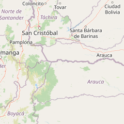
Understand where Tamá National Natural Park sits in Colombia through a broader geographic reading of the surrounding landscape, nearby location context, and its mapped position within the national park landscape.

How Tamá National Natural Park fits into Colombia

Colombia is a presidential republic located in the northern part of South America. It spans approximately 1.14 million km² and has a population of around 52 million. The country features the Andes mountain range, extensive Amazon rainforest, and coastal regions on both the Caribbean and Pacific. Spanish is the official language, and Bogotá serves as the capital and largest city.

Wider geography shaping Tamá National Natural Park in Colombia

Colombia is located in the northwestern part of South America, bordering the Caribbean Sea to the north and the Pacific Ocean to the west. Its mainland neighbors are Venezuela to the east, Brazil to the southeast, Peru and Ecuador to the south and southwest, and Panama to the northwest. The terrain is diverse, featuring the Andes mountain range in the west, Amazon rainforest in the south and east, and coastal plains along both oceans.

Map view of Tamá National Natural Park

Use this park location map to pinpoint Tamá National Natural Park in Colombia, understand its exact geographic position, and read its mapped placement within the surrounding landscape more clearly.

Pigeon | © OpenStreetMap contributors

Location context for Tamá National Natural Park

Norte de Santander
Park atlas

Compare adjacent protected areas, trace diverse Andean ecosystems, and map connected landscapes across the Tamá Massif region.

Explore Parks Near Tamá National Natural Park: Related Protected Areas and Andean Landscapes
After exploring Tamá National Natural Park, browse other national parks and protected areas located across the Colombian Andes and adjacent mountain ranges. This contextual view helps compare diverse ecosystems, identify shared conservation priorities, and understand the wider geographic spread of protected landscapes in the northern Andean region.
National parkTáchira State

El Tamá National Park: A National Park in Venezuela's Táchira State for Geographic Discovery

Mapped protected area boundaries and regional landscape context.

El Tamá National Park serves as a primary point of interest for understanding Venezuela's protected lands. Located within Táchira State, this national park offers a distinct geographic profile for atlas exploration. Users can investigate the park's mapped features and its position within the regional natural landscape, gaining insight into its role as a conservation area and a component of Venezuela's broader geography.

Area
1,390 km²
Established
1978
IUCN
II
Relief
Mountain
National parkTáchira State

Chorro El Indio National Park: Protected National Park in Táchira State's Geography

Explore mapped boundaries and regional landscape context.

Chorro El Indio National Park serves as a key protected landscape within Táchira State, Venezuela. This national park offers users detailed insights into its specific geographic setting, mapped park boundaries, and the natural terrain it encompasses. Understanding Chorro El Indio National Park through the MoriAtlas platform provides a foundation for exploring regional protected areas and their ecological significance.

Area
170 km²
Established
1989
IUCN
II
Relief
Mountain
Natural monumentColombia

Los Estoraques Unique Natural Area: Colombian Natural Monument of Eroded Pillars

Geographic Context and Landscape Atlas

Los Estoraques Unique Natural Area stands as a distinctive protected landscape within Colombia's Norte de Santander Department. This natural monument is renowned for its striking geological formations of eroded brownstone columns and pedestals, a unique erosional terrain set within the Andean foothills. The area's mapped boundaries encompass a complex ecosystem, bridging dry forest and cloud forest zones, offering significant value for understanding regional geography and the distribution of protected lands in South America.

Area
562 km²
Established
1988
IUCN
III
Relief
Mountain
National parkSantander Department

Yariguíes National Park: National Park Geography and Protected Land Atlas

Explore mapped boundaries and regional landscape context.

Yariguíes National Park stands as a crucial protected area within the Santander Department, offering a distinct landscape for geographic study. As a designated national park, it provides vital context for understanding Colombia's protected lands and their regional distribution. This detailed view allows for in-depth exploration of its mapped terrain and natural geography, suitable for atlas-oriented discovery.

Area
788.37 km²
Established
2005
IUCN
II
Scope
Terrestrial
National parkBarinas

Tapo-Caparo National Park: Mapped Boundaries and Geographic Context in Barinas, Venezuela

Explore Venezuela's Tapo-Caparo National Park's protected terrain.

Tapo-Caparo National Park is a vital protected area located in the Barinas region of Venezuela. This page offers an atlas-focused exploration of its mapped natural landscape and geographic significance within the country. Understand the protected boundaries and the specific terrain features that define Tapo-Caparo National Park, providing essential context for regional geography and protected land discovery.

Area
2,050 km²
Established
1992
IUCN
II
Relief
Mountain
National parkVenezuela

Sierra La Culata National Park: Protected Landscape Atlas of the Venezuelan Andes

Explore the páramo ecosystems and mapped terrain of this Venezuelan national park.

Sierra La Culata National Park offers a profound look into the unique geography of the Venezuelan Andes. This protected national park is characterized by its expansive páramo ecosystems, dramatic mountain peaks, and glacial lagoons, creating a distinctive high-altitude wilderness. Use this atlas-focused entry to understand the park's mapped boundaries and its significant role within the region's natural landscape context.

Area
2,004 km²
Established
1989
IUCN
II
Relief
Mountain
Watercolor painting showing green hills, a river, and distant mountains under a light sky
National parkVenezuela

Sierra Nevada National Park: Venezuela's Majestic Alpine Protected Landscape and Park Boundaries

Explore the highest peaks and glacial terrain of this Venezuelan national park.

Delve into Sierra Nevada National Park, a premier protected area situated in the high Venezuelan Andes. This national park protects a vast expanse of dramatic alpine terrain, including Pico Bolívar and numerous glacial valleys. Understand its mapped boundaries and the unique paramo and cloud forest ecosystems that define this significant natural landscape within Venezuela, offering rich context for atlas-style geographic discovery.

Area
2,764.46 km²
Established
1952
IUCN
II
Relief
Mountain
National parkVenezuela

Sierra de Perijá National Park: Protected Area in Venezuela's Geographic Atlas

Explore its national park boundaries and regional landscape context.

Sierra de Perijá National Park is a designated national park in Venezuela, representing a significant protected landscape within the country. This entry facilitates detailed atlas exploration, allowing users to understand the park's precise geographic scope, its mapped boundaries, and its connection to the surrounding regional geography. Discover the core identity of this protected area and its value for geographic study and mapped landscape analysis.

Area
2,952.88 km²
Established
1978
IUCN
II
Relief
Mountain

Common questions about visiting, size, designation, and location context for Tamá National Natural Park

Tamá National Natural Park FAQs for park facts, access, geography, and protected area context
Find quick answers about Tamá National Natural Park, including protected-area facts, park geography, trail and visitor context, and how the park fits into its surrounding country and regional landscape.
MoriAtlas Explorer

Continue Your Protected Areas Search Across the Global Atlas

Deepen your exploration by continuing the structured search for national parks and protected areas worldwide. Utilize the comprehensive filtering capabilities to compare different conservation landscapes and refine your understanding of global park geography. Discover more about the distribution and characteristics of protected natural areas.

Global natural geography