Mori Atlas logo
Protected landscapeTernowaner Wald

Tracing the limestone plateaus, sinkhole networks, and forested highland boundaries of a unique Dinaric ecological reserve.

Ternowaner Wald Protected Landscape: Mapped Geography and Dinaric Karst Terrain in Southwestern Slovenia

Ternowaner Wald serves as a central high-karst plateau within the Dinaric mountain system of southwestern Slovenia. This protected landscape encompasses a complex morphology of dolines, shafts, and extensive beech-fir forests that rise toward the Golak massif. Map-based discovery reveals how this watershed area links the Julian Alps with Inner Carniola, defined by extreme porous hydrogeology and the historic Great Ice Cave in Paradana.

karst plateauDinaric AlpsJulian Alpsbeech-fir forestlimestone landscapedolines and sinkholes

Ternowaner Wald

Protected landscape

Park overview

Structured park overview, official facts, and landscape profile for Ternowaner Wald

Ternowaner Wald park facts, protected area profile, and essential visitor context

Review the core facts for Ternowaner Wald, including designation, size, terrain, visitor scale, habitats, and operating context in one park-focused overview.

About Ternowaner Wald

Ternowaner Wald is a forested highland in southwestern Slovenia that bridges two major European landscape systems: the Julian Alps to the north and the karst belt of the Dinaric mountains to the south. The plateau stretches over roughly 35 kilometers between the Vipava valley near Ajdovščina and the area around Logatec, with elevations commonly between 700 and 1000 meters and a summit reach of almost 1500 meters at Mali Golak.

The region's identity is shaped by limestone geology and the long Dinaric influence on its hydrology. Triassic, Jurassic and Cretaceous limestones and dolomites dominate the surface, with subordinate occurrences of Mesozoic Dachstein limestone and limestone breccias. Tectonic movements have pushed younger Eocene flysch against older carbonate rocks along the southern edge, creating a structurally layered highland whose porous rocks act as deep karst aquifers. Although the plateau receives more than 2000 millimeters of precipitation in many places and ranks among Slovenia's wettest landscapes, surface streams are largely absent; instead, water moves underground toward the Vipava to the south, the Soča to the west and the Idrijca to the north.

Ecologically, Ternowaner Wald is a textbook example of the Dinaric beech and fir forest system. Forests cover more than three quarters of the surface, and because of the area's remoteness this woodland has retained much of its natural composition. Below the alpine treeline the dominant woodland is Abieti-fagetum dinaricum, succeeded at lower elevations by submontane beech forests. Dwarf willow, dwarf mountain pine and open grassland occupy the highest crests and ridges, while protected species such as the Carniolan primrose grow in rock crevices.

Protected-area designations reinforce the regional importance of the plateau. The larger Natura 2000 area Trnovski gozd-Nanos links this highland with the neighboring Nanos massif, while the Trnovski gozd European bird protection area sits within it. Additional layered protection comes from the southern landscape park along the Vipava valley flanks, the upper Idrijca landscape park to the north and a series of forest reserves, including Paradana, Golaki with Smrekova draga, and Smrečje within the Trnovski gozd. The area is also part of the wider South Alpine mean mountains and is traditionally counted within the southeastern Julian Alps.

Quick facts and research context for Ternowaner Wald

Ternowaner Wald, known in Slovenian as Trnovski gozd, is a karst plateau and mountain range in the Goriška region of southwestern Slovenia. It marks the southeastern edge of the Julian Alps and the northern fringe of the Inner Carniolan karst, with the highest point, Mali Golak, reaching 1495 meters.

The area lies about 50 kilometers west of Ljubljana and is bordered by the Vipava valley near Ajdovščina to the south and the upper Idrijca to the north. Forests cover roughly three quarters of the surface, predominantly Dinaric beech and fir woodland, and the region receives some of the heaviest precipitation in Slovenia. Its protected-area profile includes the Natura 2000 site Trnovski gozd-Nanos, a European bird protection area of the same name, and adjacent landscape parks along the Vipava valley and upper Idrijca.

Protection and recognition

Terrestrial protection framework, management context, and official designation records

Ternowaner Wald Protection Status and Documented Conservation Scope

Ternowaner Wald maintains a recorded terrestrial protection scope within its primary conservation framework. Official records compile available management parameters, designation history, and recognized status details.

Protection details

Protection scope
Terrestrial
Transboundary protection
No
Park context

Deeper park guide and search-rich context for Ternowaner Wald

Ternowaner Wald history, landscape, wildlife, and travel context

Explore Ternowaner Wald through its history, landscape character, ecosystems, wildlife, conservation priorities, cultural context, and seasonal travel timing in a structured park guide built for atlas discovery and search intent.

Why Ternowaner Wald stands out

Ternowaner Wald is best known for its deep Dinaric karst character and the Great Ice Cave in Paradana, a 385 meter deep, 1550 meter long cave containing perennial ice whose deposits were once exported internationally. The plateau is recognized for its dense network of dolines, sinkholes, shafts and cave systems believed to include some of the underground networks counted among the longest in the world. Equally defining is the ecological signature of the terrain: extensive mixed beech and fir forest of the Dinaric type blanketing a highland that rises toward the Golak massif. The combination of a wet continental-to-submediterranean climate, heavy precipitation and karst hydrogeology creates a landscape where forests, caves, protected habitats and traditional small-scale land use intersect.
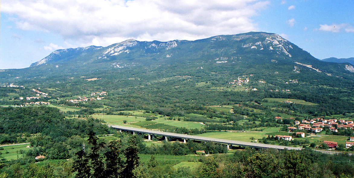
A wide mountain landscape showing a large, forested mountain ridge in the background, with a valley containing a highway viaduct and small villages in the foreground.
View of the Trnovski gozd mountain plateau from the Vipava Valley.

Ternowaner Wald history and protected-area timeline

The political-historical identity of Ternowaner Wald took shape with the extinction of the Counts of Gorizia, after which the region passed to the Habsburg realm in 1335 as part of Carniola. Through successive dynastic divisions it remained within Inner Austria, tying its later fortunes to the long Habsburg administration of the inner Alpine and pre-Alpine lands.

For centuries the local economy was dominated by woodland-based livelihoods. Charcoal production was a significant activity well into the modern era, drawing on the extensive mixed beech and fir forests of the plateau. In parallel, the unique ice deposits of the high karst were exploited as a mining resource: ice that accumulated in deep shaft caves was extracted and traded over long distances, with the Great Ice Cave in Paradana being the most famous source. Historical reports describe ice from Paradana being shipped as far as Egypt, an unusual export for an inland highland.

In more recent decades, the plateau has been reoriented around conservation and small-scale, service-oriented economies. Forestry remains central, cattle farming especially beef cattle is the main agricultural activity, and tourism has grown steadily. Hikers come for the steep karst terrain, the ice caves and the botanically interesting dolines, while population density has remained very low and the settlement pattern preserves traditional clustered villages and isolated farms.

Ternowaner Wald landscape and geographic character

The landscape of Ternowaner Wald is a high-karst plateau with a strongly Dinaric orientation. Tectonic shaping is visible throughout the area: tectonic basins, uvalas, small karst poljes and fragments of former river valleys explain much of its surface morphology. In the Pliocene, rivers worked against the steadily rising land surface, while Pleistocene glaciation left smaller cirques and ground and frontal moraines in the upper reaches.

The summit massifs of the Golaki, with Mali Golak at 1495 meters, define the eastern horizon of the plateau. The western section merges into the hinterland of Hubelj near Ajdovščina and the highland around Črni vrh, while the northwestern edges meet the Banjšice Plateau. To the southeast the landscape continues into the Birnbaumer Wald (Hrušica) and the Nanos massif, and the southern rim is marked by the plateau called Gora, also known locally as Predmeja.

Because the terrain is almost entirely karstic, surface rivers are scarce. The Hubelj spring near Ajdovščina is the strongest emergence point, and the watershed divide is unusually diffuse as drainage shifts between the Vipava basin to the south, the Soča basin to the west and the Idrijca basin to the north. The characteristic wind of the area is the burja, a powerful katabatic gust that descends from the plateau toward the coast and at times exceeds 100 kilometers per hour, frequently uprooting trees on exposed slopes.

Ternowaner Wald ecosystems, habitats, and plant life

The ecological identity of Ternowaner Wald is built around the Dinaric beech and fir forest community and the karst landscapes that support it. Roughly three quarters of the surface is forested, and the share continues to grow as former agricultural land is being reforested. Because of difficult access and extreme relief, much of the woodland has retained its natural character, with the dominant association Abieti-fagetum dinaricum forming the core forest belt between roughly 700 and 1200 meters.

Above this belt the highest summits, including the open crest of Mali Golak, grade into dwarf shrub vegetation with creeping willow species and Pinus mugo, interspersed with grassland. In rock crevices grow protected species such as the Carniolan primrose (Primula carniolica). The shrub layer of the forest is poorly developed, which is typical of dense, old-growth Dinaric forests, while soil patterns include brown carbonate soils and rendzinas developed on limestone and dolomite parent material, with locally acidic soils where chert-bearing limestones occur.

The climate is shaped by altitude and position: the plateau lies at the meeting point of continental conditions inland and the submediterranean conditions of the Vipava valley. Average annual precipitation is high, in places exceeding 2000 millimeters and locally reaching over 3000 millimeters, with a marked autumn maximum. Winters bring substantial snow at higher elevations, while the burja wind strongly influences exposure and disturbance patterns on ridges and upper slopes.

Ternowaner Wald wildlife and species highlights

Ternowaner Wald is recognized at the European level for its birdlife, which is the basis for the European bird protection area (SPA) designated under the EU Birds Directive and named Trnovski gozd. The combination of extensive mature forests, karst edge habitats, dolines with vegetation inversion and highland meadows above the forests creates a varied ecological mosaic that supports forest-dwelling and open-country bird species as well as raptor and owl species typical of the Dinaric region.

The wider landscape supports a typical mix of forest fauna: typical Dinaric forest mammal communities occur across the beech and fir belt, while small-scale agricultural land on the western fringe adds edge habitat for species associated with meadows, hedges and rural settlements. Because the area is sparsely populated and largely forested, large stretches function as effective wildlife habitat, and the Natura 2000 designation reflects the broader ecological continuity with neighboring systems such as the Nanos massif.

Cave fauna also form a distinctive component of the wildlife story, especially in the deep shaft caves and in the Great Ice Cave in Paradana and similar ice caves. These subterranean habitats host specialized invertebrates and support unique ecological behaviors tied to the cold, stable microclimate of perennial ice deposits.

Ternowaner Wald conservation status and protection priorities

Conservation is a defining frame for Ternowaner Wald. The plateau forms the core of the Natura 2000 site Trnovski gozd-Nanos, which it shares with the adjoining massif of Nanos, and the bird protection area of the same Slovenian name is a dedicated European designation. On its southern flank toward the Vipava valley the landscape is further protected through the Južni obronki Trnovskega gozda, a regional landscape park, while the northern flank along the upper Idrijca is covered by the Krajinski park Zgornja Idrijca.

Within the plateau itself, strict forest reserves concentrate protection on the most ecologically valuable forest stands, skeletal soils and microclimatic refugia: the Paradana reserve with the Great Ice Cave as a natural monument, the Golaki and Smrekova draga reserve around the highest summits, and the Smrečje v Trnovskem gozdu reserve, an important frost hollow community. Together, these reserves, the Natura 2000 designation and the surrounding landscape parks secure the continuity of the Dinaric beech and fir forest at landscape scale and protect one of Slovenia's most important karst groundwater systems.

From a hydrological perspective, the deep karst aquifers of the Ternowaner Wald are part of a single hydrogeological unit with the Birnbaumer Wald, Nanos and nearby plateaus. Their high porosity and hydraulic conductivity make the protection of surface forests and soils directly relevant to maintaining water quality and flow regimes in the Vipava, Soča and Idrijca basins.

Ternowaner Wald cultural meaning and human context

Ternowaner Wald has long been one of the most sparsely populated regions of Slovenia, with a population density of roughly 9 inhabitants per square kilometer recorded in 1991 and historical clustering on the western side of the plateau. Settlement patterns reflect the limits of the terrain: clustered hamlets and isolated farms formed under the influence of high-altitude colonization movements, and demographic structures remain weighted toward older age cohorts.

Traditional livelihoods, especially charcoal burning based on the extensive beech and fir forests, and the extraction of cave ice for trade, have left a strong imprint on the cultural memory of the area. The legacy of ice mining from caves such as Paradana connects the plateau to long-distance historical networks, reaching as far as Egypt in some accounts. Today, alongside forestry and cattle farming, especially beef cattle, increasing tourism focused on hiking, ice caves and botanically remarkable dolines has become an important part of the regional identity.

Top sights and standout views in Ternowaner Wald

Ternowaner Wald is defined by the convergence of three elements: a deep Dinaric karst plateau with sinkholes and shafts, an extensive beech and fir forest complex of the Dinaric type, and a multi-tiered protection framework including the Natura 2000 site Trnovski gozd-Nanos, the European bird protection area Trnovski gozd and adjacent landscape parks.

Among its standout features are the Great Ice Cave in Paradana with its historical ice trade, the Golak massif with Mali Golak as the highest point, and the layered protected landscape of forest reserves, karst phenomena and traditional settlements. The combination of high precipitation, deep karst hydrogeology and largely continuous forest cover makes Ternowaner Wald one of the most significant ecological reference landscapes of southwestern Slovenia.

Best time to visit Ternowaner Wald

Ternowaner Wald has a temperate continental climate with strong submediterranean influence at its southern edge. Late spring and early autumn tend to be the most balanced seasons for visiting, when highland meadows, karst flora and viewpoints are accessible without deep winter snow and without the most intense heat of the lower Vipava valley.

Winter brings heavy precipitation including snow at higher elevations, which can make upper trails and forest roads difficult, but also accents the area's ice caves and burja-driven weather patterns. Summer is generally greener and most comfortable for hiking the forest belt, though visitors should expect variable weather and the strong burja wind that frequently affects exposed slopes, ridges and plateaux.
Monthly climate preview

Long-term average temperature and monthly precipitation patterns across representative coordinates in Slovenia

Ternowaner Wald Climate Normals and Measured Weather by Month

Historical data records a measured annual temperature and precipitation rhythm across representative coordinates in Ternowaner Wald from 1991 to 2020. Examining the complete twelve-month profile reveals detailed long-term averages for monthly temperature ranges and daily precipitation totals.
Annual mean10 °C
0 °C21 °C
Jan
Feb
Mar
Apr
May14°
Jun18°
Jul21°
Aug21°
Sep16°
Oct11°
Nov
Dec
Warmest month
August

20.9 °C

Coolest month
January

0 °C

Wettest month
November

4.2 mm/day

Driest month
January

1.9 mm/day

Park location guide

Geography guide, regional context, and park location map for Ternowaner Wald

Ternowaner Wald park geography, regions, and map view in Slovenia

Understand where Ternowaner Wald sits in Slovenia through a broader geographic reading of the surrounding landscape, nearby location context, and its mapped position within the national park landscape.

How Ternowaner Wald fits into Slovenia

Slovenia is a developed European country with a population of approximately 2.1 million people. It declared independence from Yugoslavia in 1991 and joined the European Union in 2004. The country features diverse geography including the Julian Alps, forests, and a short Adriatic coastline.

Wider geography shaping Ternowaner Wald in Slovenia

Slovenia is located in Central and Southeast Europe, bordered by Italy to the west, Austria to the north, Hungary to the northeast, and Croatia to the south and southeast. It has a 46.6 km coastline on the Adriatic Sea. The terrain is mostly mountainous and forested, with the Julian Alps in the northwest.

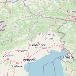
Map view of Ternowaner Wald

Use this park location map to pinpoint Ternowaner Wald in Slovenia, understand its exact geographic position, and read its mapped placement within the surrounding landscape more clearly.

Pigeon | © OpenStreetMap contributors

Explore high-resolution photography documenting limestone terrain, ancient forests, and protected habitats.

Ternowaner Wald Photos and Landscape Scenery: Visualizing the Dinaric Karst Plateau

Visual documentation reveals the dense beech and fir forests, rugged sinkholes, and dramatic limestone formations defining the protected plateau. Examining field photography helps researchers and travelers interpret the complex topography and ecological character of the Dinaric highlands.

A wide mountain landscape showing a large, forested mountain ridge in the background, with a valley containing a highway viaduct and small villages in the foreground.

Park atlas

Compare regional Dinaric highlands, neighboring karst plateaus, and connected forest reserves

Parks Near Ternowaner Wald and Surrounding Protected Areas

Browse protected areas and connected forest reserves adjacent to Ternowaner Wald in the Dinaric highlands. Extending the geographic comparison reveals broader regional ecosystems, limestone plateaus, and related natural reserves.
Regional parkSlovenia
About 30 km away#1 closest

South

Škocjan Caves Regional Park: Mapped Karst Landscape and UNESCO World Heritage Site in Slovenia

Discover its profound underground river canyon and doline geography.

Škocjan Caves Regional Park in Slovenia is a protected karst landscape of global importance, renowned for its vast subterranean system and the Reka River's underground journey. This site, a UNESCO World Heritage designation, features dramatic collapse dolines like Mala and Velika dolina, alongside immense cave chambers that illustrate classic karst hydrology. It serves as a key reference point for understanding regional geology and protected area networks within southeastern Europe's unique terrains.

Area
4.15 km²
Established
1996
IUCN
V
Relief
Lowland
Watercolor illustration of a river flowing through a forested valley with mountains in the background
National parkSlovenia
About 30 km away#2 closest

North

Triglav National Park: A Mapped Alpine Protected Landscape in Slovenia

Julian Alps geography, glacial lakes, and karst terrain.

Triglav National Park is Slovenia's premier protected area, covering 880 square kilometers of the Julian Alps. This page details its dramatic alpine geography, including Mount Triglav, glacial valleys, and significant karst features. Understand the mapped boundaries and landscape context of this national park, a key entry in the MoriAtlas geographic discovery resource for understanding protected lands.

Area
880 km²
Established
1981
IUCN
II
Visitors
1.6M annual
Protected areaFriuli-Venezia Giulia
About 36 km away#3 closest

South

Val Rosandra Protected Area: Mapped Karst Landscapes and Geography in Northeastern Italy

A canyon-like river valley and natural reference for karst phenomena

Val Rosandra stands as a defining protected area within the Friuli Venezia Giulia region, characterized by its sharp limestone cliffs, narrow gorges, and the distinct Supet waterfall. Its unique geological layering creates a compact environment where contrasting climates produce an extraordinary botanical intersection, set against a rich backdrop of historical remnants ranging from Roman aqueducts to former railway paths.

Area
7.46 km²
Established
1996
Relief
Mixed relief
Climate
Mediterranean
A soft watercolor painting of a coastal scene featuring green vegetation, a light shoreline, and hazy distant mountains.
Protected landscapeAnkaran
About 42 km away#4 closest

South

Landschaftspark Debeli rtič: Coastal Protected Landscape and Regional Geography Map

Protected marine and terrestrial landscape near Ankaran, Slovenia

Located on the Muggia Peninsula, Landschaftspark Debeli rtič protects a rare combination of flysch cliffs and shallow underwater reefs. This record provides a geographic breakdown of the park, including its distinct transition from agricultural vineyards to coastal woodland, offering a clear view of the protected area boundaries and surrounding Adriatic terrain.

Area
3.4 km²
Established
2018
Relief
Upland
Climate
Mediterranean
A soft watercolor painting of a wetland landscape featuring green meadows, gentle rolling hills, and a river flowing through the scene.
Nature reserveSlovenia
About 44 km away#5 closest

East

Naturreservat Iški morost: Protected Nature Reserve and Wetland Landscape in Central Slovenia

Mapped protected wetlands of the Ljubljana Marsh region

Naturreservat Iški morost serves as a primary conservation site for the distinct wet meadow habitats of the Ljubljana Marsh. This reserve demonstrates the intersection of wetland geography and bird conservation, protecting a crucial, coherent landscape that is rare in contemporary Slovenian lowlands.

Area
0.65 km²
IUCN
Ia
Relief
Lowland
Climate
Temperate
Watercolor illustration of a mountainous landscape with green forests, a lake, and distant pink-hued mountains under a light sky
National parkPrimorje-Gorski Kotar County
About 71 km away#6 closest

Southeast

Risnjak National Park: Protected Mountain Landscape in Primorje-Gorski Kotar

Explore karst terrain and regional geographic context.

Risnjak National Park represents a substantial protected area within the rugged mountain geography of Croatia's Gorski Kotar region. This national park is distinguished by its dramatic karst formations, diverse alpine flora reaching from forested slopes to rocky summits, and the significant natural landmark of the Kupa River's source. Discover its mapped boundaries and the ecological importance of this unique landscape situated in Primorje-Gorski Kotar County.

Area
63.5 km²
Established
1949
IUCN
II
Visitors
16.8K annual
A horizontal watercolor painting showing a soft mountain range with green forests, a winding river valley, and wildflowers in the foreground.
Protected areaAustria
About 91 km away#7 closest

Northeast

Geopark Karawanken: Alpine Protected Landscape and Tectonic Geography in Austria

A cross-border protected area defined by tectonic uplift and deep alpine valleys.

Geopark Karawanken showcases a profound geological record formed by tectonic plate convergence. The protected area features sharp mountain massifs, subterranean karst systems, and deep-cut gorges that reveal the underlying structural complexity of the alpine range, offering a clear view of how tectonic forces shape regional geography.

Area
1,067 km²
Established
2013
Relief
Mountain
Climate
Alpine
A watercolor painting showing a wide, panoramic view of rolling, grassy mountain slopes with soft pastel colors and small evergreen trees.
Protected landscapeCarinthia
About 108 km away#8 closest

North

Nock Mountains National Park: Mapping the Rounded Alpine Summits and Glacial Terrain of Carinthia

A protected alpine landscape and UNESCO Biosphere Reserve in the Austrian Alps

Discover the geographic character of Nock Mountains National Park, where the Gurktal Alps transition into sweeping, grass-covered dome summits. This protected area offers a look at a unique Tertiary land surface that survived the last Ice Age, supporting a mosaic of larch forests, alpine pastures, and high-altitude lakes that define the regional geography of southern Austria.

Area
184 km²
Established
1987
IUCN
V
Relief
Mountain

Common questions about visiting, size, designation, and location context for Ternowaner Wald

Ternowaner Wald FAQs for park facts, access, geography, and protected area context

Find quick answers about Ternowaner Wald, including protected-area facts, park geography, trail and visitor context, and how the park fits into its surrounding country and regional landscape.
MoriAtlas Explorer

Continue Your Protected Areas Search Across the Global Atlas

Deepen your exploration by continuing the structured search for national parks and protected areas worldwide. Utilize the comprehensive filtering capabilities to compare different conservation landscapes and refine your understanding of global park geography. Discover more about the distribution and characteristics of protected natural areas.

Global natural geography