Why Thaba Bosiu stands out
Thaba Bosiu is best known as the natural fortress that sheltered King Moshoeshoe I and his people after they migrated from Butha-Buthe in 1824, fleeing the widespread violence of the Difaqane and Mfecane wars. Its combination of a flat, defensible summit, encircling cliff belt, eight natural springs, and limited passes allowed it to hold off repeated attacks and to serve as the founding capital of the Basotho nation. The plateau is also renowned for resisting major nineteenth century military campaigns, most notably the 1865 Boer siege led by Louw Wepener, who was the only enemy combatant ever to reach the summit and whose name became attached to Khubelu pass. Decades later, Thaba Bosiu retained its symbolic power as a gathering place for political movements in colonial and postcolonial Lesotho, hosting critical prayer meetings, party rallies, and the burials of two kings.
Thaba Bosiu history and protected-area timeline
Thaba Bosiu entered the historical record in 1824, when Moshoeshoe I and his followers, displaced by the Difaqane and Mfecane wars of the early nineteenth century, migrated from Butha-Buthe and occupied the plateau. Its natural defenses, springs, and grazing capacity allowed them to shelter refugees, distribute cattle, and begin consolidating a new polity. The plateau served for many years as the capital of the Basotho nation and as a launching point for organized resistance against European encroachment into the central South African plateau.
In the mid-nineteenth century, the mountain became a focus of military confrontation. Mzilikazi failed in an early attempt to take Thaba Bosiu while regrouping after leaving Shaka's domain. In 1865, the Orange Free State launched a sustained siege of the plateau, the most famous episode being the assault of 18 August 1865 led by Commandant Louw Wepener with roughly 6,000 Boer troops. Only about 100 men remained with Wepener by late afternoon, and although he reached the summit of Khubelu pass, he was struck by a bullet and killed. The siege continued into 1866, and under the resulting starvation the Basotho eventually signed a treaty in April 1866 surrendering about 3,000 cattle and over two-thirds of their arable land.
The plateau itself, however, remained unconquered. In 1867, after further fighting during the Third Free State-Basotho War, Moshoeshoe I requested British protection, which was granted in March 1868 on the eve of a renewed Boer attack on Thaba Bosiu. Lesotho became a British territory, and the mountain's surviving inviolability gave it enduring symbolic value.
During the twentieth century the site retained its political resonance. In 1957, Lekhotla la Bafo and the Basotoland Congress Party held a joint meeting on the summit, foreshadowing later opposition mobilization. On 27 December 1966, King Moshoeshoe II organized protest and prayer meetings at Thaba Bosiu against the government of Prime Minister Chief Leabua Jonathan; security force action resulted in deaths and arrests, and Moshoeshoe II was placed under house arrest.
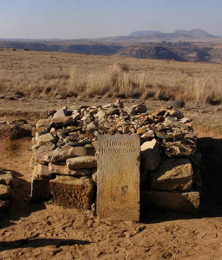
In 1967, the Lesotho government declared the mountain a national monument. In the 1990s the United Nations Development Programme worked with the Basotho government on a Preservation and Presentation programme to safeguard the site. In 1996, Moshoeshoe II was buried on the plateau alongside Moshoeshoe I, reinforcing Thaba Bosiu's status as a royal and national resting place.
Thaba Bosiu landscape and geographic character
Thaba Bosiu is defined by a striking contrast between its broad, flat-topped summit and the deeply incised valley system that surrounds it. The plateau lies within the valley of the Phuthiatsana River, between the Orange and Caledon Rivers, and rises roughly 106 meters above the surrounding terrain. Its most distinctive physical feature is a near-continuous belt of perpendicular cliff faces running along the summit rim, averaging about 12 meters in height and effectively separating the flat upper surface from the slopes below.
Access to the summit is controlled by six passes carved into or through the encircling cliffs, the best known of which is Khubelu pass. The narrow, steep nature of these routes, combined with the protective cliff belt, gives the mountain its fortress-like profile. The summit itself is wide enough to accommodate livestock, dwellings, and subsistence activity, while the plateau's contained area is balanced by the presence of eight natural springs, which secured the site's ability to support a population during extended sieges.
Geologically, the plateau belongs to a broader Basotho landscape in which sandstone is interleaved with quartzite and basalt formations, producing hard, layered caprock and erosional cliffs. The wider region lying between the Orange and Caledon Rivers contains sandstone ridges, river valleys, and the kind of open highland scenery typical of Lesotho's western lowlands and foothills. In the vicinity of Thaba Bosiu, surviving San rock art sites add an additional layer of landscape heritage, anchoring a long human presence to this particular stretch of valley and plateau.
Thaba Bosiu ecosystems, habitats, and plant life
Although Thaba Bosiu is primarily recognized for its historical and cultural importance rather than for ecological superlatives, the plateau and its surroundings sit within a varied Lesotho landscape shaped by sandstone, basalt, and quartzite formations and bounded by the Orange, Caledon, and Phuthiatsana river systems. The summit itself, ringed by cliffs and only accessible through a small number of passes, has historically supported grazing livestock and provided a relatively sheltered micro-environment distinct from the valleys below.
The surrounding lowlands, which transition between the sandstone plateau and the broader river valleys, host the mixed grassland and shrub vegetation typical of Lesotho's western reaches. The eight springs on the mountain sustain small pockets of wetter habitat at and near the summit, while the cliff environments provide nesting and shelter sites for various birds and small mammals accustomed to rocky terrain. The wider Maseru District landscape, with its seasonal rivers and basalt ridges, supports the kind of pastoral and agro-pastoral land use that has long characterized the region.
The presence of San rock art sites near Thaba Bosiu hints at the long-term ecological value of the area, providing evidence that the surrounding landscape has supported human communities and the wildlife they interacted with for many generations. While the plateau is small in extent, its distinctive combination of cliffs, springs, and valley-edge habitats gives it a recognizable ecological character that complements its role as a refuge and gathering place.
Thaba Bosiu wildlife and species highlights
Reliable details on the modern wildlife of the Thaba Bosiu plateau itself are limited, and the site is best understood in terms of the broader Lesotho lowland and foothill fauna that shares its setting. The cliffed summit, with its near-perpendicular rock faces and sheltered ledges, offers habitat for rock-dwelling and cliff-nesting birds typical of the region's sandstone escarpments, while the eight summit springs attract a range of smaller birds and animals associated with reliable water sources in an otherwise dry seasonal landscape.
In the surrounding valleys and slopes, the mosaic of grasslands, shrubs, basalt ridges, and seasonal watercourses supports the pastoral and wildlife patterns common to western Lesotho. Cattle, sheep, and goats have shaped this landscape since Moshoeshoe I first concentrated livestock on the plateau in 1824, and traditional agro-pastoral land use continues to influence habitat structure. Native fauna of the broader area includes typical southern African highland species, and the plateau's protected status contributes to maintaining a relatively undisturbed patch within an otherwise cultivated region.
Rather than being a wildlife destination in the conventional safari sense, Thaba Bosiu is better appreciated as a place where the small-scale interplay between cliffs, springs, grasslands, and grazing pressure has produced a distinctive and historically important ecological setting, complementing the site's primary role as a national monument and cultural landscape.
Thaba Bosiu conservation status and protection priorities
Thaba Bosiu's conservation significance is tightly bound to its identity as a national monument rather than to a strictly ecological designation. In 1967, the Lesotho government declared the mountain a national monument, giving it formal protection and recognizing both its historical role and its landscape values. The plateau has since functioned as an anchor site for heritage-focused conservation, with particular attention to preserving the summit's historical buildings, routes, and royal graves against weathering, erosion, and informal development.
Beginning in the 1990s, the United Nations Development Programme worked together with the Basotho government on a Preservation and Presentation of Thaba Bosiu programme, supporting infrastructure, interpretation, and management of the monument. The base of the mountain now hosts a cultural village, an information centre, a conference facility, and rondavel-style accommodation, all of which operate under a model that pairs heritage tourism with ongoing site protection. This framework also reflects an effort to involve local communities in stewardship of the monument.
From a conservation perspective, the plateau's cliffs, springs, and natural passes are themselves part of what is being protected, since the very features that historically defended the site are also its most fragile geological assets. Whether one values Thaba Bosiu for its sandstone geology, its Basotho political heritage, or its continuing role as a royal burial ground, the monument's conservation status helps ensure that this layered landscape remains intact for future study and visitation.
Thaba Bosiu cultural meaning and human context
Thaba Bosiu is a foundational site in Basotho culture and political identity, embodying both the origin story of the nation and a continuing tradition of using the mountain as a gathering place for political and spiritual occasions. The name itself translates loosely as Mountain at Night, evoking the founding moment when Moshoeshoe I and his followers arrived under cover of darkness in 1824. Subsequent beliefs that the mountain grows larger at night, or that earth taken from it mysteriously returns, have reinforced Thaba Bosiu's standing as a place imbued with protective spiritual power.
The plateau's role as a unifying refuge during the Difaqane and Mfecane upheavals underpins much of Basotho collective memory, and it is from this experience that Moshoeshoe I built the political structures of the modern nation. In the twentieth century, Thaba Bosiu continued to function as a stage for collective political expression: Lekhotla la Bafo and the Basotoland Congress Party met there in 1957, and in 1966 King Moshoeshoe II organized a prayer meeting on the plateau in protest against the government of Chief Leabua Jonathan, an event now known as the Thaba Bosiu Affair.
The plateau also preserves a tangible material heritage, including the stone house and other buildings constructed with the assistance of David Webber of the 72nd Seaforth Highlanders in 1837, as well as nearby San rock art that speaks to a still-earlier human relationship with the landscape. Today, the cultural village at the base of the mountain, the burial sites of Moshoeshoe I and Moshoeshoe II on the summit, and ongoing commemorative gatherings sustain Thaba Bosiu's role as a living cultural landmark at the heart of Basotho identity.
Top sights and standout views in Thaba Bosiu
Thaba Bosiu's defining feature is its combination of natural fortress geology with an extraordinary concentration of Basotho heritage. The plateau's flat summit, encircling cliff belt, eight natural springs, and limited passes made it nearly impregnable in the nineteenth century, and this geography is inseparable from the historical events that shaped Lesotho. The mountain is the site where the Basotho nation was effectively founded, where successful resistance was mounted against the Orange Free State in 1865, and where British protection was requested in 1868.
For visitors, the experience of Thaba Bosiu combines a striking geological setting with a layered cultural landscape. The base hosts a cultural village, an information centre, a conference facility, and rondavel accommodation, while the plateau above preserves historical structures, the graves of two kings, and panoramic views over the Phuthiatsana valley towards the Orange and Caledon Rivers. Nearby San rock art adds an additional prehistoric dimension, making Thaba Bosiu a site where geology, nineteenth-century history, and contemporary Basotho culture converge within a single compact landscape.
Best time to visit Thaba Bosiu
Thaba Bosiu can be visited year-round, but the character of the experience varies considerably with the seasons typical of Lesotho's western lowlands and foothills. Summer months, running roughly from October through March, bring the warmest temperatures and the highest likelihood of afternoon thunderstorms, which can make the steeper passes slippery and the surrounding grasslands vivid green. This is also when the rivers of the valley, including the Phuthiatsana, Caledon, and Orange River systems, are most likely to be flowing strongly, enhancing the scenery at the foot of the plateau.
Winter months, from approximately May to August, are typically dry, cold, and clear, with crisp conditions on the summit and stable weather for walking the passes and exploring the plateau. The bare winter landscape offers particularly sharp views of the cliff belt and surrounding sandstone ridges, although temperatures at the 1,804-meter elevation can drop sharply after sunset. Shoulder seasons often combine manageable temperatures with fewer visitors, providing quieter conditions for those interested in the historical and architectural remains on the summit, including the sites associated with Moshoeshoe I and Moshoeshoe II.