
Mori Atlas logo
Marine protected areaThe Manacles

Analyzing the jagged rock formations, protected maerl beds, and submerged maritime history along the Lizard Peninsula

The Manacles Marine Protected Area: Exploring the Complex Reef Geography and Underwater Terrain of Cornwall

The Manacles represents a complex mosaic of protected marine habitats located off the eastern coast of Cornwall's Lizard Peninsula. This reef system comprises a series of shallow pinnacles, vertical rock faces, and sheltered sediment channels that support a diverse marine ecosystem. By examining the mapped boundaries and seafloor topography, users gain insight into the convergence of deep-water habitats and historical navigation hazards defining this coastal area.

marine conservation zonereefshipwrecksdivingmaerl bedsCornwall coast
A stylized vector illustration of a waterfall cascading off a cliff into a body of water next to a rocky outcrop, framed by evergreen trees under a soft, light-colored sky.

The Manacles

Marine protected area

Park overview

Structured park overview, official facts, and landscape profile for The Manacles

The Manacles park facts, protected area profile, and essential visitor context

Review the core facts for The Manacles, including designation, size, terrain, visitor scale, habitats, and operating context in one park-focused overview.

About The Manacles

The Manacles occupies a stretch of water just off the coast of the Lizard Peninsula, the southernmost tip of Cornwall's mainland. The reef begins at Manacle Point near the small village of Porthoustock and extends out into Falmouth Bay in a broad arc of partially exposed rocks, submerged ledges, and deeper channels. Because the rocks sit close to the shipping lane leading to Falmouth, one of the most important natural harbours in southern England, the area has been a magnet for maritime traffic, and consequently for maritime accidents, for centuries.

The reef itself is not a single rock but a scattered constellation of named formations. The northern Middle Manacles include Maen Chynoweth, also known as Morah, a name derived from the Cornish word for dolphin, as well as Chyronos, Maen Gerrick, and the Gwinges. To the east lie Vase Rock and Pen Vin, while the central cluster holds the Minstrel Rock, Carn-dhu, the sound-shaped Maen Voes (the Voices), and the Quants. Maen Land marks the south-western edge of the reef. Each of these names reflects the long Cornish seafaring tradition and a folk memory of the sea that has grown up around these landmarks.

Although the rocks have always been central to the identity of the area, the modern significance of The Manacles is increasingly framed in ecological terms. The site was designated a Marine Conservation Zone on 21 November 2013, recognising both the exceptional biodiversity and the structural complexity of the seabed. Today The Manacles is simultaneously a working seascape, a heritage site, a recreational diving destination, and a protected marine environment, a layering that gives the location its unusual combination of cultural and natural importance.

Quick facts and research context for The Manacles

The Manacles is a reef system off the Lizard Peninsula in Cornwall, traditionally pronounced locally as 'mean-a-klz'. The name derives from the Cornish 'meyn eglos', meaning 'church stones', a reference to the visible spire of St Keverne church from the area. The reef lies in Falmouth Bay and stretches about a nautical mile from Manacle Point. In 2013 it was designated a Marine Conservation Zone covering roughly 3.5 square kilometres, making it one of the recognised marine protected areas on England's south coast.

Protection and recognition

Documented protection history and marine conservation scope for The Manacles

The Manacles Protection Status and Marine Designated Area Records

Marine protection status and formal designation history for The Manacles establish a clear baseline for conservation records established in 2013. Structured maritime data provides documented management scope and official recognition details without third party assumptions.

Protection details

Protection scope
Marine
Designated year
2013
Transboundary protection
No
Park context

Deeper park guide and search-rich context for The Manacles

The Manacles history, landscape, wildlife, and travel context

Explore The Manacles through its history, landscape character, ecosystems, wildlife, conservation priorities, cultural context, and seasonal travel timing in a structured park guide built for atlas discovery and search intent.

Why The Manacles stands out

The Manacles is best known for two contrasting identities: a notorious graveyard of ships along the approach to Falmouth, and a thriving marine habitat that draws scuba divers from across the UK. The combination of shallow, jagged rocks and historic wrecks within easy reach of the shoreline has created a landscape where every dive intersects layers of naval history and living marine ecology. The site's maerl beds and reef communities underscore its status as both a culturally significant seascape and a scientifically recognised marine conservation area.
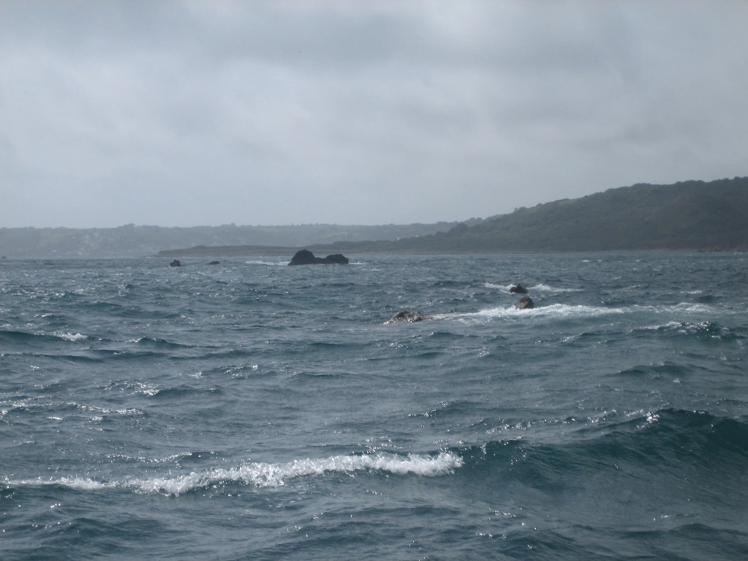
A view of the Manacles rocks and reefs protruding from the sea off a coastal headland under a cloudy sky.
The Manacles rocks and reefs off the Lizard Peninsula in Cornwall.

The Manacles history and protected-area timeline

The Manacles has been a recognised hazard to shipping for as long as vessels have approached Falmouth from the south and east. Records indicate that more than one hundred ships have been wrecked on the reef and that over a thousand lives have been lost there. The combination of the reef's exposed rocks and the heavy traffic bound for Falmouth, historically a major British port, created an enduring pattern of maritime loss through the eighteenth and nineteenth centuries.

Among the most notable casualties is HMS Primrose, an 18-gun Cruizer-class brig-sloop that sank on 22 January 1809 with only one survivor from 126 aboard. The emigrant ship John, carrying 263 passengers bound for Canada, struck Maen Land in May 1855 and only 86 survived. The Greek steamer Spyridon Vagliano, loaded with grain bound for Falmouth from Novorossiysk, went down on 8 February 1890 with 14 of her 22 crew lost. The most celebrated wreck of all is the SS Mohegan, which struck the rocks on 14 October 1898 with 106 fatalities, an event immortalised by the Dundonian poet William McGonagall in his widely known poem 'The Wreck of the Steamer Mohegan'.

In 1885 Trinity House was petitioned to place a lightship near the reef, after statistics showed that sixteen vessels, carrying a total of 693 crew and passengers, had been lost in the previous decade, with ships and cargoes valued at around £100,000. Despite the scale of the losses, Trinity House decided in May 1890 that neither a lightship nor a lighthouse was necessary. The decision left navigation through the area dependent on seamanship, local knowledge, and the visual landmarks of the Lizard coast. In the modern era, the site's formal recognition came with the designation of The Manacles Marine Conservation Zone in November 2013, marking a shift in how the reef is valued: from a place defined by loss toward one recognised for the richness of its marine life.

The Manacles landscape and geographic character

The Manacles forms a rocky seascape rather than a terrestrial landscape, but its visual character is no less defined. The reef consists of numerous jagged rocks that break the surface, interspersed with submerged pinnacles and shallow ledges that lurk just below the tide line. Seen from the cliff paths around the Lizard, particularly from the headland near Porthoustock and looking south-west toward Coverack, the rocks appear as a dark, broken line of sea-stained stone fringed by white water, an outlook that has become an iconic coastal view in this part of Cornwall.

Below the waves, the physical structure of the reef is exceptionally varied. Steep rock faces descend into deeper water, while flatter areas of the seabed hold subtidal sand and coarse sediment. Shallow pockets between the rocks accumulate maerl, the chalky remains of red seaweeds that build up over time into distinctive beds. This underwater topography is not only scenic, it is structurally crucial, because each type of surface, vertical wall, broken boulder, sand patch, and maerl bed creates a slightly different environment for marine life to colonise.

The terrestrial surroundings reinforce the maritime character of the site. The Lizard Peninsula to the west is one of the most geologically unusual parts of Britain, with serpentine rock formations and grasslands reaching almost to the cliff edge. Small settlements such as St Keverne and Porthoustock sit just inland, and the spire of St Keverne church is itself part of the cultural geography of the reef; the Cornish name for the rocks, 'meyn eglos', translates as 'church stones', a phrase preserving the connection between the visible coastline and the hidden hazards offshore.

The Manacles ecosystems, habitats, and plant life

The Manacles supports one of the richest concentrations of marine life on the south coast of England. The seabed of the Marine Conservation Zone incorporates rocky reefs, vertical rock faces, patches of subtidal sand, and stretches of intertidal coarse sediment, and each of these habitats supports a distinctive marine community. The structural diversity of the reef, with its pinnacles, crevices, and sheltered channels, provides an unusually wide range of niches for both plants and animals.

A particular feature of the site is the presence of maerl beds. Maerl refers to several species of red seaweeds whose hard, chalky skeletons accumulate over time to form loose, branching structures on the seabed. These beds are considered ecologically valuable because they host juvenile fish and invertebrates and create complex microhabitats. Beyond maerl, the rocks and sediments support dense populations of sea anemones, sea cucumbers, and sea urchins, together with a broader suite of reef-associated marine life that thrives in the clear, nutrient-rich waters of Falmouth Bay.

Although The Manacles is best characterised as a marine site, the broader setting on the Lizard Peninsula also adds ecological context. The headland is recognised for its unusual terrestrial flora, including heath and grassland communities that have adapted to the serpentine geology. Together, the marine and terrestrial environments create a layered ecological mosaic in which the reef plays a central, defining role.

The Manacles wildlife and species highlights

The wildlife most closely associated with The Manacles is marine rather than terrestrial. Divers visiting the reef regularly report an abundance of anemones in a wide range of colours and shapes, together with sea cucumbers along the sediment-rich areas and sea urchins grazing the rocky faces. The crevices and overhangs of the reef offer shelter to crustaceans and small fish, while juvenile stages of several species use the maerl beds as nursery habitat. The result is a marine community that is dense, varied, and visible to anyone prepared to descend below the surface.

The dramatic topography of the reef, with many shallow wrecks sitting in less than six metres of water, adds another wildlife dimension. Over time, shipwrecks become artificial reefs, their steel and timber surfaces colonised by anemones, soft corals, bryozoans, and a host of small invertebrates. This secondary habitat interacts with the natural rock to amplify the biological richness of the site.

Above water, wildlife interest continues through the seabirds that frequent the Lizard coast, including species that patrol the nearshore waters for fish driven toward the surface by reef predators. Although the birdlife of The Manacles itself is less prominent than its marine fauna, the wider Lizard Peninsula provides one of the most important ornithological areas in southern England, meaning that the reef sits within a larger ecological landscape that extends well beyond the waterline.

The Manacles conservation status and protection priorities

The Manacles was designated a Marine Conservation Zone on 21 November 2013, formal recognition of the site's importance as one of the more ecologically significant reef systems on England's south coast. The MCZ covers an area of approximately 3.5 square kilometres and extends from Porthoustock Point south to Polcries, reaching outward into the sea to a distance of around two kilometres from the coast. The boundaries were drawn to capture the full range of reef-associated habitats that make the site valuable.

What gives the conservation designation its weight is the variety of habitats within the zone. The seabed is not uniform: it incorporates rocky reefs, near-vertical rock walls, subtidal sand, and coarse intertidal sediment. The shallow sediments host maerl beds, which are recognised as a particularly sensitive and ecologically valuable feature. Because maerl grows only slowly, its accumulation is a long-term process, and the presence of established beds is an indicator of relatively undisturbed conditions. Protecting these habitats allows the wider community of anemones, sea cucumbers, sea urchins, and juvenile fish to persist over time.

Conservation significance also extends beyond any single species. The structural complexity of the reef creates habitat for the full life cycle of many marine animals, from juveniles that shelter in maerl and crevices to adults that patrol the rock walls. By preserving this combination of physical structure and biological diversity, the MCZ designation contributes to a network of protected marine sites along the Cornish coast, reinforcing the region's reputation as a stronghold of marine biodiversity in the United Kingdom.

The Manacles cultural meaning and human context

The cultural identity of The Manacles is inseparable from the maritime culture of Cornwall. The Cornish name 'Meyn Eglos', meaning 'church stones', is not just a descriptive phrase but a small piece of living heritage: it links a hidden offshore hazard to a visible, named landmark on land, the spire of St Keverne church, which can be seen from the reef on a clear day. The preservation of a Cornish-language name for such a prominent site reflects the deep linguistic traditions of the peninsula.

The reef also occupies a notable place in Cornish cultural memory through the literature it has generated. The SS Mohegan disaster of 1898 became the subject of a widely circulated poem by William McGonagall, whose work enjoyed enormous popularity in Victorian Britain. The poem, which dramatised the loss of life on the rocks, brought The Manacles into public awareness far beyond Cornwall and embedded the reef in a wider British memory of maritime tragedy.

Local communities around the Lizard have long been shaped by the presence of the reef. Generations of fishing families, lifeboat crews, and coastguards have known its rocks by name, and the traditional Cornish pronunciation 'mean-a-klz' continues to mark a locally rooted way of speaking about the site. Although the modern conservation framing of The Manacles is comparatively recent, the cultural relationship between Cornwall and the reef is one of the oldest layers of the site's identity.

Top sights and standout views in The Manacles

The Manacles combines dramatic underwater scenery with more than a century of maritime history in a single reef system off Cornwall's Lizard Peninsula. Divers are drawn by the diversity of the seabed, which ranges from vertical rock walls and broken boulder fields to sheltered maerl beds, and by the unusually high concentration of historic wrecks in shallow water. Ecologists value the site as one of the clearer examples of a maerl-rich, reef-protected marine environment on the English Channel coast, while historians and visitors encounter a tangible piece of Cornish maritime heritage in wrecks such as HMS Primrose, the John, the Spyridon Vagliano, and the SS Mohegan. The Cornish-language name 'Meyn Eglos', the visible St Keverne spire, and the traditional pronunciation 'mean-a-klz' add a distinctive cultural layer that makes The Manacles more than just a hazard charted on a nautical map.

Best time to visit The Manacles

The Manacles is a year-round site for diving and marine exploration, but conditions change meaningfully with the seasons. Summer typically offers the calmest seas, the warmest water, and the longest daylight hours, making it the most accessible period for less experienced divers and for boat-based visits to the reef. Visibility tends to be at its best in late spring and early summer, when plankton blooms have settled and clear water allows the full drape of the reef walls to be appreciated.

Autumn brings a change in character, with cooler water temperatures and often stronger currents, but it is also a productive season for marine wildlife observation as many species reach seasonal peaks of activity. Winter visits, while more challenging due to weather and sea state, can reveal a quieter, more dramatic version of the reef, with fewer boats and a moodier coastal atmosphere. Because the site is exposed and partially open to the Atlantic, weather windows matter more than calendar months; calm, settled conditions typically produce the best experience at any time of year.

Monthly climate preview

Long-term representative averages and weather by month for Cornwall

The Manacles Climate Normals, Annual Temperature and Precipitation Rhythm

Representative coordinates record measured monthly temperature swings and precipitation rates across the landscape of The Manacles. Examining the complete twelve-month profile provides deeper analytical context on long-term climate normals and seasonal variations.
Annual mean12 °C
8 °C17 °C
Jan
Feb
Mar
Apr10°
May12°
Jun15°
Jul17°
Aug17°
Sep15°
Oct13°
Nov11°
Dec10°
Warmest month
August

16.8 °C

Coolest month
February

8.2 °C

Wettest month
November

4 mm/day

Driest month
May

2.1 mm/day

Park location guide

Geography guide, regional context, and park location map for The Manacles

The Manacles park geography, regions, and map view in United Kingdom

Understand where The Manacles sits in United Kingdom through a broader geographic reading of the surrounding landscape, nearby location context, and its mapped position within the national park landscape.

How The Manacles fits into United Kingdom

The United Kingdom is a parliamentary constitutional monarchy located in northwestern Europe, consisting of four constituent countries: England, Scotland, Wales, and Northern Ireland. As a major global power with over 69 million residents, it maintains significant international influence in politics, economics, and culture.

Wider geography shaping The Manacles in United Kingdom

The United Kingdom is an island nation located in northwestern Europe, surrounded by the Atlantic Ocean, North Sea, English Channel, Celtic Sea, and Irish Sea. It shares a land border with the Republic of Ireland to the west. The territory includes the island of Great Britain, the northeastern portion of Ireland, and most of the smaller British Isles islands.

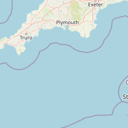
Map view of The Manacles

Use this park location map to pinpoint The Manacles in United Kingdom, understand its exact geographic position, and read its mapped placement within the surrounding landscape more clearly.

Pigeon | © OpenStreetMap contributors

Location context for The Manacles

Cornwall

Visual exploration of rocky reef topography, coastal habitats, and marine environments.

The Manacles Photos and Landscape Scenery: Protected Seascape Views

Visual documentation reveals the jagged reef formations and submerged topography that define the protected marine environment of The Manacles. Examining these coastal and underwater views provides clear insight into the complex habitats and maritime scenery of the Cornish coast.

A view of the Manacles rocks and reefs protruding from the sea off a coastal headland under a cloudy sky.

Park atlas

Compare adjacent marine reserves and surrounding regional park geography.

Exploring Other Parks Near The Manacles and Protected Coastal Landscapes

Browsing other protected areas near The Manacles reveals connected marine habitats and rugged coastal terrain across the Cornish peninsula. Expanding the search helps travelers examine regional park geography and compare similar conservation zones along the English Channel.
A soft watercolor illustration depicting a coastal landscape with green marshy vegetation, a calm body of water, and rolling hills in the background.
Marine protected areaCornwall
About 27 km away#1 closest

West

Mounts Bay Marine Conservation Zone: Exploring Marine Protected Areas in South Cornwall

Subtidal reefs and coastal seagrass habitats in the English Channel.

This protected marine landscape off the coast of Cornwall covers diverse underwater habitats including the Greeb reef and the waters surrounding St Michael's Mount. The area is characterized by its significant seagrass beds, which act as vital nursery habitat for fish and shellfish species. Explore the structural geography of this marine protected area and its position within the broader coastal environment of South West England.

Area
12 km²
Established
2016
Relief
Lowland
Climate
Temperate
A watercolor illustration featuring soft, abstracted layers of green hills, a light blue horizon, and subtle pink and earthy tones representing land and water.
Protected areaCornwall
About 41 km away#2 closest

North

River Gannel Protected Area: Cornwall Coastal Estuary and Marine Conservation Zone

Mapped tidal channels and coastal landscape geography in Cornwall

River Gannel provides a focal point for understanding the tidal geography of northern Cornwall. From its inland source to the dynamic estuary separating Newquay and Crantock, the area features protected marine habitats, sand dunes, and deep-rooted industrial heritage. This record details the physical boundaries and ecological significance of this coastal landscape as it drains into the Celtic Sea.

Established
2016
Relief
Lowland
Climate
Temperate
Access
Easy access
A pale, minimalist watercolor painting showing soft green hills and a gentle shoreline against a white background.
Protected landscapeCornwall
About 45 km away#3 closest

West

Gwennap Head Protected Landscape: Coastal Geography and Granite Cliffs in Cornwall

Mapped Atlantic terrain and regional maritime boundaries

Located at the western edge of the Penwith peninsula, Gwennap Head defines a harsh yet productive coastal environment. This protected landscape features vertical granite cliffs, the treacherous Runnel Stone reef, and open maritime heath. Its geography serves as a vital watchpoint for migratory seabirds and a nexus of historic maritime activity, offering a well defined study of Cornwall's exposed Atlantic coastline.

Relief
Upland
Climate
Temperate
Access
Easy access
Scope
Mixed
Watercolor illustration of Dartmoor moorland landscape with rolling hills, grassy vegetation, a stream, and distant mountains.
National parkDevon
About 81 km away#4 closest

Northeast

Dartmoor National Park: Granite Tors and Prehistoric Landscape in Devon

Mapped protected area with significant Bronze Age remains.

Dartmoor National Park represents a distinctive granite upland in Devon, England, characterized by its dramatic tors and expansive moorland. This protected landscape is globally significant for its dense concentration of prehistoric archaeological sites, including stone circles, standing stones, and ancient settlements. Exploring Dartmoor offers a unique insight into Britain's regional geography, mapped terrain, and enduring connection to ancient human history.

Area
954 km²
Established
1951
IUCN
V
Visitors
11M annual
A soft watercolor illustration featuring rolling hills in the background, a tree line in the midground, and a winding waterway in the foreground.
Biosphere reserveDevon
About 124 km away#5 closest

North

North Devon's Biosphere Reserve: Protected Landscapes and Geographic Map Exploration

Coastal dunes, estuaries, and marine habitats in North Devon

An extensive overview of North Devon's Biosphere Reserve, highlighting its role as a protected landscape in South West England. Analyze the distribution of its diverse terrain, including Britain's largest sand dune system, river catchments, and offshore coral reefs, through detailed geographic and habitat mapping.

Area
5,262 km²
Established
1976
Visitors
4M annual
Relief
Lowland
Watercolor painting of a coastline with rolling green cliffs meeting the sea, with small pink flowers in the foreground.
Protected landscapeUnited Kingdom
About 134 km away#6 closest

Northeast

Jurassic Coast Protected Landscape: Geological Mapping and Coastal Atlas

A comprehensive look at sedimentary formations in the United Kingdom

Trace the 96-mile stretch of the Jurassic Coast, a protected landscape revealing Triassic, Jurassic, and Cretaceous rock layers. The terrain serves as a vital record of Earth history, featuring distinctive geomorphological landmarks like Chesil Beach and the towering cliffs of Golden Cap, all defined by the dynamic interaction of land and sea.

Established
2001
Relief
Upland
Climate
Temperate
Access
Easy access
Watercolor painting depicting a landscape with rolling hills, a winding road, and distant mountains
National parkUnited Kingdom
About 144 km away#7 closest

Northeast

Exmoor National Park: A Premier Protected Landscape in South West England for Atlas Exploration

Mapped terrain, moorland, and dramatic coastal geography.

Discover Exmoor National Park, a vast protected area in South West England celebrated for its sweeping heather moorland, dramatic coastline with the highest sea cliffs on mainland Britain, and deep, ancient wooded valleys. This national park offers a unique landscape for atlas-based exploration, revealing its distinct geography, mapped boundaries, and rich terrain shaped by centuries of natural processes and human activity.

Area
692 km²
Established
1954
IUCN
V
Visitors
1.4M annual
A soft, painterly watercolor illustration of a winding river flowing through green marshlands, coastal dunes, and gentle rolling hills under a bright, open sky.
Nature reserveFinistère
About 163 km away#8 closest

South

Réserve naturelle régionale des marais, dunes et baies de Guissény: Protected Atlas Detail

Coastal reserve geography and maritime landscape mapping

Located in Finistère, this protected area features an intricate network of reedbeds, dune ridges, and coastal lagoons. The reserve provides a critical refuge for over 200 bird species and serves as a prime example of the land-and-sea ecological transition characteristic of the northern Breton coastline.

Area
6.083 km²
Established
2025
IUCN
IV
Relief
Lowland

Common questions about visiting, size, designation, and location context for The Manacles

The Manacles FAQs for park facts, access, geography, and protected area context

Find quick answers about The Manacles, including protected-area facts, park geography, trail and visitor context, and how the park fits into its surrounding country and regional landscape.
MoriAtlas Explorer

Continue Your Protected Areas Search Across the Global Atlas

Deepen your exploration by continuing the structured search for national parks and protected areas worldwide. Utilize the comprehensive filtering capabilities to compare different conservation landscapes and refine your understanding of global park geography. Discover more about the distribution and characteristics of protected natural areas.

Global natural geography