Mori Atlas logo
National parkTingo María National Park

Mapping the protected boundaries and natural geography of this national park entity.

Tingo María National Park: Peru's Protected Landscape in the Huánuco Region

(Parque Nacional Tingo María)

Tingo María National Park stands as a protected natural area within the Huánuco Region of Peru. As a designated national park, it offers a distinct geographic scope for atlas exploration. Understanding its mapped boundaries and regional landscape context provides valuable insight into Peru's protected lands and natural terrain.

Montane ForestCave SystemsNational ParkPeru Protected AreasBirdwatchingMountain Landscapes

Tingo María National Park

National park

Park overview

Structured park overview, official facts, and landscape profile for Tingo María National Park

Tingo María National Park park facts, protected area profile, and essential visitor context
Review the core facts for Tingo María National Park, including designation, size, terrain, visitor scale, habitats, and operating context in one park-focused overview.

About Tingo María National Park

Tingo María National Park occupies a significant ecological niche in central Peru's protected areas network. Located in the Huánuco Region, the park sits at the transition between the Amazon basin and the Andean foothills, creating a montane forest environment with high biodiversity value. The park's establishment in 1965 through Law No. 15574 represented an early effort to preserve Peru's forest resources, though the law initially lacked defined boundaries. The subsequent boundary definition in 2000 solidified the park's extent at 4,777.8 hectares. The area's ecological importance stems from its montane forest character, which differs substantially from the lowland rainforests found in many other Peruvian protected areas. The Cueva de las Lechuzas serves as both a geological curiosity and an important habitat for colonial nesting birds, while the Bella Durmiente massif provides both scenic value and ecological heterogeneity within the park's boundaries. The confluence location gives the park its name and contributes to the underground river systems that have formed within the calcareous mountain geology.

Quick facts and research context for Tingo María National Park

Tingo María National Park covers 4,777.8 hectares of mountainous terrain in central Peru's Huánuco Region. The park protects montane forest ecosystems at elevations ranging from 650 to 1,808 meters above sea level. The Bella Durmiente massif, a prominent geological formation, occupies nearly the entire park area with rocky walls reaching 300 to 500 meters in height. The Cueva de las Lechuzas cave is home to nesting oilbirds, one of the park's most notable wildlife attractions. The park is managed by SERNANP, Peru's national protected areas service. The local Quechua etymology of 'tingo' refers to the confluence of rivers, reflecting the park's geographic position at the meeting of the Huallaga and Monzón rivers.

Park context

Deeper park guide and search-rich context for Tingo María National Park

Tingo María National Park history, landscape, wildlife, and travel context
Explore Tingo María National Park through its history, landscape character, ecosystems, wildlife, conservation priorities, cultural context, and seasonal travel timing in a structured park guide built for atlas discovery and search intent.

Why Tingo María National Park stands out

Tingo María National Park is best known for its dramatic combination of humid montane forest and distinctive geological features. The park's signature landmark is the Bella Durmiente (Sleeping Beauty) massif, a visually striking mountain formation that resembles a reclining figure and defines the park's visual identity. The Cueva de las Lechuzas (Cave of the Owls) represents another major attraction, where visitors can observe oilbirds nesting within the cave's dark chambers. The very humid montane forest vegetation, frequently cloaked in mist and supporting trees adorned with epiphytes, mosses, and lichens, creates an atmosphere of tropical wilderness that distinguishes this protected area from the more typical Amazonian lowland parks of Peru.

Tingo María National Park history and protected-area timeline

The protected status of Tingo María National Park evolved over several decades. In 1940, two years after the founding of the nearby town of Tingo María, forest areas were set aside from development to establish a protected natural area. Under the dictatorship of Manuel A. Odría in 1950, a formal protected area designated as Cueva de las Lechuzas National Reserve was created, covering the future park's territory. On May 14, 1965, Law No. 15574 established Tingo María National Park, specifying that the protected area should include the Bella Durmiente massif, the Cueva de las Lechuzas cave, and adjacent forests. However, this founding legislation did not specify the total area or precise boundaries of the park, leaving those details unresolved for decades. In 2000, boundaries were finally defined and the total area was fixed at 4,777.8 hectares, completing the formal establishment of the park's protected status.

Tingo María National Park landscape and geographic character

The topography of Tingo María National Park is characterized by steep and mountainous terrain, with the Bella Durmiente massif occupying nearly the entire park area. Elevations within the park range from 650 meters to 1,808 meters above sea level. The landscape features prominent rocky walls typically reaching 300 to 500 meters in height, creating dramatic cliffs and escarpments throughout the protected area. The underlying geology consists of calcareous rock formations, which have influenced the park's hydrology by creating underground river courses as water has eroded through the limestone. Soils in the park are typically calcareous, rocky, and thin, making the terrain susceptible to landslides from both natural causes and historical agricultural activities. The park is positioned at the confluence of the Huallaga and Monzón rivers, where the Quechua-derived name 'tingo' meaning confluence or meeting reflects this geographic junction.

Tingo María National Park ecosystems, habitats, and plant life

The vegetation of Tingo María National Park is classified as very humid montane forest, frequently enveloped in mist and characterized by high humidity levels. The forest ecosystem features trees extensively colonized by epiphytes, mosses, and lichens, creating a lush and visually distinctive environment. The park supports a diverse array of tree species including cedro colorado (Cedrela odorata), palo blanco (Cinchona pubescens), cumala blanca (Virola calophylla), and quinilla (Manilkara bidentata). Palm species such as huasaí (Euterpe precatoria), ungurahui (Oenocarpus bataua), and yarina (Phytelephas macrocarpa) are also present. Tree ferns (Cyathea spp.) add to the structural complexity of the forest, while numerous orchid species, particularly from the genus Phragmipedium, represent the park's botanical diversity, though some species like Phragmipedium besseae face conservation threats.

Tingo María National Park wildlife and species highlights

Tingo María National Park supports a diverse mammalian fauna characteristic of montane forest environments in Peru. Notable mammal species include the South American tapir, red brocket, collared peccary, and ocelot. Several primate species inhabit the park, including the black-capped squirrel monkey, brown-mantled tamarin, and red-faced spider monkey. Other mammals present include the nine-banded armadillo, pacarana, Northern Amazon red squirrel, kinkajou, and South American coati. The bird fauna is particularly noteworthy, with species such as the Andean cock-of-the-rock, oilbird, white-eyed parakeet, Salvin's curassow, Spix's guan, blue-headed parrot, king vulture, and Amazonian motmot recorded in the area. The Cueva de las Lechuzas specifically provides nesting habitat for oilbirds, which are among the most distinctive avian inhabitants.

Tingo María National Park conservation status and protection priorities

Tingo María National Park faces several environmental challenges that affect its biodiversity and ecological integrity. Primary threats include wood extraction for construction and fuel, forest clearance for agricultural crops including coca cultivation and pasture creation, and uncontrolled tourism activities. Hunting and fishing practices, including the use of toxins and explosives, also impact wildlife populations. Noise disturbance from helicopters at a nearby airbase affects the park's acoustic environment. More specific infrastructure concerns include obstruction of an underground river due to debris from deforestation in nearby villages, and extraction of gravel and construction materials from within the park boundaries. The park's conservation value lies in its representation of montane forest ecosystems distinct from lowland Amazon areas, its protection of geological features including significant cave systems, and its role in preserving habitat for species including threatened orchids.

Tingo María National Park cultural meaning and human context

The cultural context of Tingo María National Park relates primarily to the geographic and linguistic heritage of the region. The park's name derives from the Quechua language, specifically from the word 'tingo' meaning confluence or meeting, reflecting the park's position at the junction of the Huallaga and Monzón rivers. This Quechua etymology connects the protected area to the indigenous linguistic heritage of the Huánuco Region. The park is named after the nearby town of Tingo María, which was founded in 1938, two years before the initial forest protection efforts began. The Spanish language designation 'Parque Nacional Tingo María' serves as the official name, while the Bella Durmiente (Sleeping Beauty) massif name reflects Spanish language influence applied to the distinctive geological formation.

Top sights and standout views in Tingo María National Park

Tingo María National Park's standout features include the iconic Bella Durmiente massif, a dramatically shaped mountain that forms the visual centerpiece of the protected area and gives the landscape its distinctive character. The Cueva de las Lechuzas cave system, where oilbirds nest, represents a unique ecological and geological attraction that draws visitors interested in cave exploration and wildlife observation. The very humid montane forest environment, with its mist-shrouded trees covered in epiphytes and the diverse orchid populations, provides exceptional botanical interest. The park's location at the confluence of two major rivers and its position in the Andean foothills create a transitional ecosystem that supports both montane and Amazonian species. The elevation range from 650 to 1,808 meters encompasses diverse habitats within a relatively compact area.

Best time to visit Tingo María National Park

The optimal time to visit Tingo María National Park depends on seasonal climate patterns. The area experiences a rainy season from October through April, with mean annual precipitation reaching 3,300 millimeters. Access to the park during this period is limited due to weather conditions, trails can become hazardous, and the persistent cloud cover may obscure the scenic views of the Bella Durmiente massif. The dry season months typically offer more favorable conditions for hiking and exploration, though mist and humidity remain characteristic features of the montane forest environment year-round. Annual temperatures range from a minimum of 19.2°C to a maximum of 29.8°C, with a mean of 24.5°C, creating a warm but not extreme climate. Visitors interested in birdwatching, particularly at the Cueva de las Lechuzas to observe oilbirds, may find different experiences across seasons depending on bird activity patterns.

Park location guide

Geography guide, regional context, and park location map for Tingo María National Park

Tingo María National Park park geography, regions, and map view in Peru
Understand where Tingo María National Park sits in Peru through a broader geographic reading of the surrounding landscape, nearby location context, and its mapped position within the national park landscape.

How Tingo María National Park fits into Peru

Peru is a megadiverse country in western South America with a population of over 34 million. It spans three distinct geographic regions: the Pacific coastal desert in the west, the Andes mountains running north to south, and the Amazon rainforest in the east. The country has one of the longest histories of civilization in the world, tracing back to the Caral-Supe civilization of the 10th millennium BCE, and was home to the Inca Empire before Spanish colonization in the 16th century.

Wider geography shaping Tingo María National Park in Peru

Peru is located in western South America along the Pacific coast. The country encompasses three major geographic regions: the coastal desert plains along the Pacific, the Andes mountain range extending from north to southeast, and the Amazon basin rainforest in the eastern interior. It shares borders with Ecuador and Colombia to the north, Brazil to the east, Bolivia to the southeast, and Chile to the south.

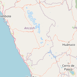
Map view of Tingo María National Park

Use this park location map to pinpoint Tingo María National Park in Peru, understand its exact geographic position, and read its mapped placement within the surrounding landscape more clearly.

Pigeon | © OpenStreetMap contributors

Location context for Tingo María National Park

Huánuco Region
Park atlas

Trace the regional spread of protected areas surrounding Tingo María, comparing diverse Peruvian mountain and Amazonian forest landscapes.

Explore Other National Parks and Protected Areas Near Tingo María, Peru's Mountainous Cloud Forests
After exploring Tingo María National Park's unique montane forest and Bella Durmiente massif, browse a curated list of other protected areas and national parks across central Peru. This geographical comparison reveals the wider network of conservation landscapes, offering insights into diverse mountain terrain, rich forest ecosystems, and connected river systems in the surrounding region.
National parkPasco Region

Yanachaga, Chemillén National Park: Protected Area in Pasco Region, Peru

Mapped terrain, Pleistocene refuge, and rich biodiversity.

Yanachaga, Chemillén National Park, a national park situated in Peru's Pasco Region, preserves over 122,000 hectares of mountainous cloud forest and rainforest ecosystems. Its landscape is characterized by dramatic canyons and steep forested slopes, creating significant altitudinal variation from 460 to 3,643 meters. Recognized as a Pleistocene refuge, the park shelters ancient forest remnants and harbors exceptional biodiversity, including hundreds of bird species and iconic mammals, offering rich context for geographic and protected-area exploration.

Area
1,220 km²
Established
1986
IUCN
II
Relief
Mountain
National parkAncash

Huascarán National Park: Protected Landscape and Regional Geography in Ancash, Peru

Explore the mapped boundaries of this significant national park.

Huascarán National Park is a protected national park located in the Ancash region of Peru, offering valuable insights for geographic and atlas exploration. This destination provides detailed information on the park's mapped boundaries, its designation as a national park, and its integration into the regional geography. Understanding Huascarán National Park helps contextualize protected land distribution and landscape features within Peru for those interested in structured geographic discovery and atlas-style mapping.

Area
3,400 km²
Established
1975
IUCN
II
Relief
Mountain
National parkPeru

Cordillera Azul National Park: A National Park for Geographic Discovery in Peru

Explore Peru's protected landscape and regional map context.

Cordillera Azul National Park serves as a dedicated entry point for understanding Peru's protected natural areas through a geographic lens. This park's identity is tied to its specific mapped boundaries and its contribution to the nation's diverse terrain. Focusing on Cordillera Azul National Park allows for detailed atlas exploration of its unique landscape context within western South America, providing factual data for geographic understanding.

Area
13,531.9 km²
Established
2001
IUCN
II
Relief
Mountain
National parkSan Martín Region

Rio Abiseo National Park: Peru's Protected Landscape Identity and Geographic Context

Discover the mapped boundaries and regional atlas information.

Investigate Rio Abiseo National Park, a designated national park situated within the San Martín Region of Peru. This detailed entry focuses on its protected landscape characteristics and its specific geographic placement. Understand the park's mapped boundaries and its role in the broader atlas of protected areas, offering a structured approach to geographic discovery.

Area
2,745.2 km²
Established
1983
IUCN
II
Relief
Mountain
National parkPeru

Sierra del Divisor National Park: Peru's Sacred Amazonian Protected Landmark

Explore dramatic mountain terrain and protected lowland rainforest.

Sierra del Divisor National Park in Peru is a vital protected area conserving over 1.35 million hectares of Amazon rainforest. Characterized by the unique Sierra del Divisor mountain range and the sacred pyramid peak of Cerro El Cono, the park offers a distinct landscape within the broader Amazon basin. As one of Peru's newer national parks, it represents a significant commitment to preserving critical biodiversity corridors and understanding the geographic context of protected lands in a region facing environmental pressures.

Area
13,544.8 km²
Established
2015
IUCN
II
Relief
Mixed relief
National parkPeru

Otishi National Park: A Protected National Park Landscape in Peru's Geography

Explore the mapped boundaries and regional landscape of Otishi National Park.

Otishi National Park represents a significant protected area within Peru, offering a unique lens through which to explore regional geography and conservation landscapes. As a designated national park, it highlights the mapped boundaries and the natural terrain that defines this part of South America. Understanding Otishi National Park provides essential context for regional park discovery and the broader atlas of protected lands in Peru.

Area
3,059.73 km²
Established
2003
IUCN
II
Relief
Mountain
National parkCajamarca Region

Cutervo National Park: Peru's Oldest National Park Atlas and Protected Landscape

Andean Montane Forests and Mapped Geography of a Pioneering Protected Area

As Peru's oldest national park, established in 1961, Cutervo National Park offers a unique glimpse into the protected geography of the northern Peruvian Andes. Located in the Cajamarca Region, it preserves diverse Andean montane forests and páramo grasslands across a significant elevation gradient from 1,550 to 3,500 meters. This page details the park's landscape, including its role as a headwater conservation area and its position within a critical South American ecoregion, providing rich context for geographic and protected-area exploration.

Area
82.14 km²
Established
1961
IUCN
II
Relief
Mountain
National parkMadre de Dios Region

Manu National Park: A National Park with Mapped Boundaries in Madre de Dios Region

Explore its protected landscape and regional geography.

Gain a detailed understanding of Manu National Park, a key protected area situated in Peru's Madre de Dios Region. This page offers in-depth information on its geographic context, allowing for focused exploration of its mapped terrain and its identity as a national park. Understand how this protected landscape contributes to the regional geography and provides a solid anchor for atlas-based research and discovery.

Area
17,162.9 km²
Established
1973
IUCN
II
Relief
Mixed relief

Common questions about visiting, size, designation, and location context for Tingo María National Park

Tingo María National Park FAQs for park facts, access, geography, and protected area context
Find quick answers about Tingo María National Park, including protected-area facts, park geography, trail and visitor context, and how the park fits into its surrounding country and regional landscape.
MoriAtlas Explorer

Continue Your Protected Areas Search Across the Global Atlas

Deepen your exploration by continuing the structured search for national parks and protected areas worldwide. Utilize the comprehensive filtering capabilities to compare different conservation landscapes and refine your understanding of global park geography. Discover more about the distribution and characteristics of protected natural areas.

Global natural geography