Why Tunku Abdul Rahman National Park stands out
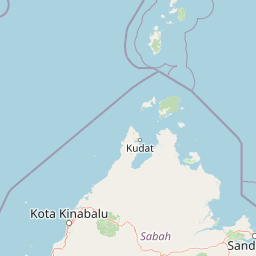
Tunku Abdul Rahman National Park is best known for its cluster of five tropical islands offering accessible beach, snorkeling, and diving experiences within minutes of downtown Kota Kinabalu. Gaya Island, the largest, features dense virgin tropical forest, over 20 kilometers of hiking trails, and upscale eco-resorts, while maintaining its designation as a forest reserve since 1923. The park is particularly recognized for its coral reef systems surrounding all five islands, the dramatic sandstone cliffs and cave formations along shorelines, and the contrast between developed island facilities and natural landscapes. Manukan Island serves as the most popular destination for local residents, while Sulug remains the most untouched and tranquil of the five islands.
Tunku Abdul Rahman National Park history and protected-area timeline
The islands within Tunku Abdul Rahman National Park have a human history extending back to the British colonial period. In 1882, the British North Borneo Company established a trading settlement on Gaya Island called Api-Api, which served as an early administrative center before the settlement was relocated to the mainland. This mainland settlement eventually became Jesselton, named after Sir Charles Jessel, and was later renamed Kota Kinabalu in 1968. The protected area itself was formally established in 1974 when the major portions of Gaya and Sapi islands were gazetted as a national park covering 8,990 acres. The park was expanded in 1979 to its current extent of 12,185 acres through the inclusion of Manukan, Mamutik, and Sulug islands. The park was named to honor Tunku Abdul Rahman, Malaysia's first Prime Minister, recognizing his role in the country's independence and early development. Sabah Parks, the state-level conservation authority, serves as the governing body responsible for managing the park's protected areas and visitor facilities.
Tunku Abdul Rahman National Park landscape and geographic character
The landscape of Tunku Abdul Rahman National Park centers on five islands characterized by their geological origins and coastal formations. The islands rise from the South China Sea with elevations reaching up to 300 meters on Gaya, the largest island, where several ridges peak at nearly 1,000 feet. The underlying geology consists of folded sandstone and sedimentary rock belonging to the Crocker Range formation, with exposed outcrops along coastlines creating dramatic cliff formations, cave systems, honeycombed erosion patterns, and deep crevices. The islands supported dense virgin tropical forests before European contact, with Gaya Island retaining extensive forest cover and having been designated a forest reserve as early as 1923. Sandy beaches characterize several islands, with Police Beach on Gaya Island offering a 400-meter stretch of white sand sloping gently into clear waters. The marine landscape features coral reef systems ringing the islands, with reef patches particularly notable along the southern coast of Sulug and the northeastern tip of Mamutik. The contrast between the forest-covered interior slopes and the coastal marine environment defines the park's visual character.
Tunku Abdul Rahman National Park ecosystems, habitats, and plant life
The nature of Tunku Abdul Rahman National Park encompasses both terrestrial and marine ecosystems across its five islands. Terrestrially, the islands support dense tropical forest vegetation, with Gaya Island maintaining extensive virgin forest cover that has been protected since 1923. The forest habitats support various wildlife species, with macaques notably present on Sapi Island. The marine environment represents a significant portion of the park's ecological value, with coral reef systems surrounding all five islands. The reef areas support diverse marine life and provide excellent conditions for snorkeling and diving activities. The park's position relative to the mainland and its island cluster creates a mosaic of habitats from coastal forest through marine environments, supporting biodiversity within a relatively compact area. The Malay-language source also notes the presence of the
Tunku Abdul Rahman National Park conservation status and protection priorities
Tunku Abdul Rahman National Park serves as an important protected area within Sabah's conservation network, representing both terrestrial forest protection and marine ecosystem preservation. The park's designation as IUCN Category II reflects its national park status and the formal protection afforded to its natural values. Gaya Island's forest reserve status since 1923 demonstrates the longest-standing conservation commitment within the park, predating the national park establishment by more than five decades. The park protects coral reef ecosystems that, despite their proximity to Kota Kinabalu, remain in excellent condition and support viable marine communities. Sabah Parks serves as the managing authority responsible for balancing conservation objectives with visitor access and sustainable tourism development. The marine components of the park, comprising approximately two-thirds of the total area, receive protection under the national park designation, preserving underwater habitats and reef systems from destructive practices.
Tunku Abdul Rahman National Park cultural meaning and human context
Tunku Abdul Rahman National Park exists within the cultural landscape of Sabah, a Malaysian state on Borneo with a complex history of indigenous communities and colonial administration. The islands themselves have historical significance dating to the British North Borneo Company period when Gaya Island hosted an early trading settlement called Api-Api in 1882. The park is named after Tunku Abdul Rahman, Malaysia's first Prime Minister, connecting the protected area to the national narrative of independence and state formation. The park's proximity to Kota Kinabalu, which developed from that early colonial settlement, creates a unique relationship between the urban center and its island-based protected areas. Gaya Island contains a stilt village housing migrants from the Philippines, representing contemporary human settlement within the park's boundaries that presents management challenges for the conservation authority. The island names themselves reflect local linguistic heritage, with Gaya derived from the Bajau word "Goyoh" meaning "big" and Sapi translating to "Cow Island" in Malay.
Top sights and standout views in Tunku Abdul Rahman National Park
The highlights of Tunku Abdul Rahman National Park include its accessible island experience just minutes from downtown Kota Kinabalu, making tropical protected area recreation available without extensive travel. Gaya Island offers over 20 kilometers of hiking trails through virgin tropical forest, along with upscale eco-resort accommodations at Gayana Eco Resort, which houses a Marine Ecology Research Centre. The coral reef systems surrounding all islands provide excellent snorkeling and diving opportunities, with reefs along Gaya's coast described as surprisingly good given their urban proximity. Each island presents a distinct character, from Manukan's popularity with locals and developed facilities to Sulug's tranquil, undeveloped atmosphere. The dramatic sandstone cliff and cave formations along shorelines add geological interest to the beach and marine attractions. Police Beach on Gaya Island offers a particularly attractive 400-meter white sand stretch fronting the Bunga Raya Island Resort.
Best time to visit Tunku Abdul Rahman National Park
Tunku Abdul Rahman National Park can be visited throughout the year given its equatorial climate, with temperatures consistently between 23.8 and 29.4 degrees Celsius. The park experiences relatively high humidity throughout the year, typical of tropical marine environments. Visitors seeking optimal conditions for underwater activities such as snorkeling and diving should consider that conditions remain generally favorable year-round, though weather patterns in Sabah may influence sea conditions and visibility. The dry season typically falls between March and October, while November through February may bring more rainfall. Those preferring quieter island experiences might consider visiting outside peak tourist hours or during less crowded periods, as Sapi Island in particular becomes quite busy between 10 AM and 4 PM when ferries arrive. Early mornings and late afternoons offer more tranquil experiences across all islands.