Mori Atlas logo
National parkTuruépano National Park

Discover the mapped boundaries and natural terrain of this Venezuelan national park.

Turuépano National Park: Protected Landscape and Regional Geography in Sucre State

(Parque nacional Turuépano)

Turuépano National Park represents a significant protected natural area within Venezuela's Sucre State. This page provides an atlas-focused perspective on the park, detailing its geographic scope and landscape context. Explore the mapped boundaries and understand its place within the regional geography, offering a clear view of its protected status and natural terrain.

Coastal WetlandsMangrove ForestsManatee HabitatBirdwatchingDelta EcosystemMarine Protected Area

Turuépano National Park

National park

Park overview

Structured park overview, official facts, and landscape profile for Turuépano National Park

Turuépano National Park park facts, protected area profile, and essential visitor context

Review the core facts for Turuépano National Park, including designation, size, terrain, visitor scale, habitats, and operating context in one park-focused overview.

About Turuépano National Park

Turuépano National Park occupies a remarkable position along Venezuela's northeastern coastline, where the interplay between continental freshwater systems and Caribbean marine waters has produced a complex and biologically productive wetland environment. The park lies within the Benítez, Cajigal, Libertador, and Mariño municipalities of Sucre State, extending across deltaic lowlands that slope gently toward the Gulf of Paria. This geographical setting places the protected area at the southern edge of a vast coastal wetland system that forms part of the larger Orinoco Delta, creating an ecological transition zone that supports species adapted to both brackish and fully marine conditions. The park's terrain is characterized by low-lying deltaic plains that become flooded during seasonal water fluctuations, extensive mangrove forests that tolerate varying salinity levels, and a network of natural channels and artificial canals that dissect the wetland landscape. These waterways serve as navigation routes, drainage systems, and critical habitat corridors for aquatic species. The establishment of Turuépano as a national park in 1991 reflected Venezuela's recognition that this coastal ecosystem required formal protection to preserve its ecological integrity and the biodiversity it supports. The park's designation under IUCN Category II acknowledges its dual function of protecting natural landscapes while enabling sustainable interactions between humans and the environment.

Quick facts and research context for Turuépano National Park

Turuépano National Park protects a distinctive deltaic wetland ecosystem in northeastern Venezuela along the Gulf of Paria. The park covers roughly 726 square kilometers of coastal lowlands within Sucre State, established in 1991 as part of Venezuela's national protected area network. The landscape consists primarily of mangrove swamps, natural channels, and shallow lagoons that form where deltaic plains meet marine waters. This transition zone between freshwater river systems and the Caribbean sea creates one of the country's most ecologically significant coastal habitats, providing critical refuge for the West Indian manatee population. The park's climate remains consistently warm year-round with temperatures averaging between 26.9°C and 27.8°C, reflecting its location in the tropical zone.

Protection and recognition

Analyzing the 1991 designation history and management scope within the conservation network

Protection Status and Environmental Designation of Turuépano National Park

National park registry data tracks the mixed protection status and designation history established for Turuépano National Park in 1991. Geographic records outline the management framework of the protected boundaries to help researchers analyze regional conservation networks and official status.

Protection details

Protection scope
Mixed
Designated year
1991
Transboundary protection
No
Park context

Deeper park guide and search-rich context for Turuépano National Park

Turuépano National Park history, landscape, wildlife, and travel context

Explore Turuépano National Park through its history, landscape character, ecosystems, wildlife, conservation priorities, cultural context, and seasonal travel timing in a structured park guide built for atlas discovery and search intent.

Why Turuépano National Park stands out

Turuépano National Park is best known for its exceptional coastal wetland ecosystem, representing a rare example of deltaic plains with significant marine influence within Venezuela. The park's extensive mangrove forests and interconnected canal systems provide the primary habitat for the West Indian manatee, a gentle marine mammal that remains the most iconic resident of these protected waters. The Caño Viejo channel and Blanca Lagoon stand out as particularly significant zones within the park, serving as concentrated areas for birdlife where numerous species either reside permanently or pause during migratory journeys. This combination of critical mangrove habitat, marine mammal protection, and outstanding birdwatching opportunities makes Turuépano one of Venezuela's most important coastal conservation areas.

Turuépano National Park history and protected-area timeline

Turuépano National Park was formally established through Venezuelan Presidential Decree No. 1,634, signed on June 5, 1991, creating the legal framework for protecting this significant coastal wetland area. The decree's publication in Official Gazette No. 34,987 on June 17, 1992, completed the formal designation process and brought the park under the management authority of Venezuela's national park system. The establishment of Turuépano reflected growing awareness during the late 1980s and early 1990s of the need to conserve Venezuela's coastal wetland ecosystems, which had faced increasing pressure from agricultural expansion, fishing activities, and infrastructure development. The park's creation also responded to scientific documentation of the area's importance as manatee habitat, recognizing that these protected waters provided essential feeding and breeding grounds for the West Indian manatee population. Since its establishment, the park has served as a focal point for conservation efforts targeting this vulnerable marine mammal species and the broader wetland ecosystem upon which it depends.

Turuépano National Park landscape and geographic character

The landscape of Turuépano National Park is defined by its position at the interface between terrestrial and marine environments, where the flat deltaic plains of the Orinoco system meet the waters of the Gulf of Paria. The terrain consists almost entirely of low-lying wetlands that remain at or near sea level, with elevation changes of only a few meters across vast stretches of the park. Dense mangrove forests dominate the vegetation, forming extensive stands along the coastline, around lagoon margins, and along the banks of the numerous channels and canals that traverse the area. These mangroves, species of Rhizophora and other salt-tolerant trees, create a distinctive landscape of twisted roots, arching branches, and dense canopy that shades the water below. The canal network within the park includes both natural channels that have formed over geological time and artificial waterways that have been dredged for transportation and drainage purposes. Shallow lagoons such as Blanca Lagoon provide open-water habitat within the mangrove matrix, offering sheltered areas where water birds gather and where the park's most visible wildlife encounters occur. The overall visual character is one of endless green corridors of mangrove stretching toward distant horizons, broken only by the silver ribbons of water that connect the various wetland habitats.

Turuépano National Park ecosystems, habitats, and plant life

The nature of Turuépano National Park centers on its representation of the Orinoco Delta swamp forests ecoregion, one of the most distinctive tropical wetland ecosystems in South America. This ecoregion encompasses a vast complex of flooded forests, mangrove swamps, freshwater marshes, and coastal lagoons that together support extraordinary biological productivity. Within the national park boundaries, the deltaic plains experience regular tidal influence, creating brackish water conditions that support mangroves and other species tolerant of variable salinity. The constant tropical temperatures, with annual variation limited to approximately 2 degrees Celsius, create conditions for year-round biological activity without the seasonal dormancy periods that characterize temperate ecosystems. The park's canal and lagoon systems provide important habitat structure, offering feeding areas, resting sites, and movement corridors for aquatic and semi-aquatic species. The combination of sheltered coastal waters, extensive shading from mangrove canopy, and nutrient-rich sediments supports a complex food web that extends from microscopic organisms through fish, crustaceans, and ultimately to the large mammals and birds that most visitors come to observe.

Turuépano National Park wildlife and species highlights

The wildlife of Turuépano National Park is most famously represented by the West Indian manatee, a large aquatic mammal that inhabits the park's channels, lagoons, and coastal waters throughout the year. These gentle creatures, which can reach lengths of over four meters and weights exceeding 500 kilograms, feed on aquatic vegetation in the shallow protected waters where they are commonly spotted by visitors and researchers alike. The park's birdlife is exceptionally diverse, with the Caño Viejo area and Blanca Lagoon serving as particularly important concentration points for both resident and migratory species. Herons, egrets, ibises, and spoonbills are commonly observed wading in the shallow waters, while pelicans and terns fish in the more open channels. The mangrove forests provide nesting habitat for colonial waterbirds and shelter for numerous land bird species. Fish populations within the canal systems support both the manatee population and the fishing activities of local communities, while crabs and other shellfish inhabit the mangrove root systems. The wetland environment also supports reptiles including caimans and various snake species, adding to the biodiversity that makes this park significant from a conservation perspective.

Turuépano National Park conservation status and protection priorities

Turuépano National Park plays a crucial role in Venezuela's conservation framework, protecting one of the country's most significant coastal wetland ecosystems and the species that depend upon it. The designation as a national park provides legal protection for the mangrove forests, lagoon systems, and wildlife populations within its boundaries, limiting destructive activities such as large-scale development, commercial logging, and practices that would degrade water quality. The park's importance for the West Indian manatee cannot be overstated, as the protected waters provide essential habitat for this vulnerable species that has faced population declines throughout its range due to hunting, boat strikes, and habitat loss. The Orinoco Delta swamp forests ecoregion, of which Turuépano is a part, has been recognized internationally for its biodiversity significance, and the national park status ensures that representative samples of this ecosystem remain protected for future generations. The conservation value of the park extends beyond individual species to encompass the broader ecological processes that maintain water quality, cycle nutrients, and provide natural flood control for the surrounding coastline.

Turuépano National Park cultural meaning and human context

The landscape of Turuépano National Park has been shaped by centuries of human presence, with local communities maintaining connections to the wetland environment through fishing, traditional land use, and cultural practices. The municipalities surrounding the park are home to communities whose livelihoods have historically depended on the coastal waters and mangrove resources, with fishing representing an important economic activity that continues today. The park's establishment created a framework for balancing conservation objectives with the sustainable use of natural resources by local populations, recognizing that the long-term protection of the wetland ecosystem depends upon the cooperation and support of neighboring communities. The Spanish-language designation of the park as Parque nacional Turuépano reflects the Venezuelan context in which the protected area was created, with the park name derived from local toponymy that connects the protected landscape to regional cultural identity.

Top sights and standout views in Turuépano National Park

The most distinctive highlights of Turuépano National Park include its extensive mangrove forest landscape that forms one of the largest coastal wetland protected areas in Venezuela, the reliable presence of West Indian manatees in its protected waters, and the exceptional birdwatching opportunities found at sites like Blanca Lagoon and Caño Viejo where numerous species can be observed in their natural habitat. The park's unique position at the boundary between Caribbean marine waters and Orinoco Delta freshwater systems creates a distinctive ecological character that sets it apart from other Venezuelan protected areas. Visitors traveling the park's canals by boat can experience the intimate environment of the mangrove tunnels, where the canopy closes overhead and the calls of birds and the splashes of fish create a vivid sense of tropical wetland immersion. The park's relative remoteness and limited infrastructure contribute to a sense of wilderness exploration that distinguishes it from more accessible national parks in Venezuela.

Best time to visit Turuépano National Park

The best time to visit Turuépano National Park considers the tropical climate of the Gulf of Paria region, where temperatures remain warm throughout the year and rainfall patterns rather than temperature changes define seasonal conditions. The park can be visited during any month, as the consistently warm temperatures between 26.9°C and 27.8°C ensure comfortable conditions for exploration regardless of the calendar. However, the dry season from approximately December through April tends to offer more stable weather conditions with less frequent rainfall, making this period popular for visitors seeking to maximize time on the water and minimize weather-related disruptions to excursions. The wet season brings increased rainfall and higher water levels that can affect wildlife viewing in some areas but also improves conditions for observing manatees as they feed in shallower flooded zones. Bird migrations bring seasonal concentrations of species to the park's lagoons, with different species present during different times of year, meaning that repeat visitors may experience notably different wildlife displays depending on when they choose to travel.

Monthly climate preview

Analyze long term temperature trends and precipitation cycles in Sucre State

Average Temperatures and Weather by Month for Turuépano National Park

Long term meteorological data at a representative lowland coordinate show sustained warm tropical temperatures alongside a distinct shift from dry intervals to periods of increased daily precipitation. Analyzing the complete monthly climate normals offers a deeper look at the subtle temperature and moisture rhythms within the protected wetland ecosystem.
Annual mean27 °C
25 °C28 °C
Jan26°
Feb25°
Mar26°
Apr26°
May27°
Jun27°
Jul27°
Aug27°
Sep28°
Oct28°
Nov27°
Dec26°
Warmest month
September

27.8 °C

Coolest month
February

25.4 °C

Wettest month
July

5.1 mm/day

Driest month
February

0.9 mm/day

Park location guide

Geography guide, regional context, and park location map for Turuépano National Park

Turuépano National Park park geography, regions, and map view in Venezuela

Understand where Turuépano National Park sits in Venezuela through a broader geographic reading of the surrounding landscape, nearby location context, and its mapped position within the national park landscape.

How Turuépano National Park fits into Venezuela

Venezuela is a country in northern South America with coastline along the Caribbean Sea and Atlantic Ocean. It borders Colombia, Brazil, Guyana, and Trinidad and Tobago. The country has an area of approximately 916,445 km² and a population of about 31.8 million. Caracas is the capital and largest city. Venezuela consists of 23 states and the Capital District.

Wider geography shaping Turuépano National Park in Venezuela

Venezuela is located on the northern coast of South America. The continental territory is bordered by the Caribbean Sea and Atlantic Ocean to the north, Colombia to the west, Brazil to the south, and Guyana to the east. Trinidad and Tobago lies to the northeast. The country includes various islands and islets in the Caribbean Sea known as the Federal Dependencies.

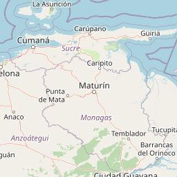
Map view of Turuépano National Park

Use this park location map to pinpoint Turuépano National Park in Venezuela, understand its exact geographic position, and read its mapped placement within the surrounding landscape more clearly.

Pigeon | © OpenStreetMap contributors

Location context for Turuépano National Park

Sucre State
Recorded earthquake history

Explore the Historical Earthquake Records for Turuépano National Park

Review the seismic record for the wetlands and canals surrounding Turuépano National Park through this consolidated historical catalogue. MoriAtlas provides these records to assist in the study of regional seismic activity and historical epicentre distribution near this coastal protected area.

Turuépano National Park Earthquake History

Catalogued events

659 events

Strongest magnitude

Magnitude 7.3

Most recent event

Jul 20, 2026

This history includes earthquakes recorded inside the park or within 50 km of its borders

Park atlas

Compare coastal wetland ecosystems and trace broader protected landscapes across Venezuela's eastern regions.

Explore Nearby National Parks and Protected Areas Around Turuépano National Park

Browse other national parks and protected areas located geographically close to Turuépano National Park, enabling comparative exploration of Venezuela's diverse conservation landscapes. Delve into regional park geography to map connected coastal wetlands, delta ecosystems, and unique protected habitats beyond this specific marine-influenced area.
National parkSucre
8.4 km away#1 closest

East

Península de Paria National Park: Venezuela's Protected Landscape Geography and Atlas Context

Explore mapped park boundaries and regional geographic setting.

Discover Península de Paria National Park, a vital protected area within the Sucre region of Venezuela. This page offers a detailed look at the park's geographic identity, focusing on its mapped boundaries and its significance as a national park for atlas-based exploration. Understand its landscape context and its contribution to Venezuela's network of protected lands, providing a clear geographic overview for researchers and explorers.

Area
375 km²
Established
1978
IUCN
II
Relief
Mountain
National parkMonagas
24 km away#2 closest

South

Cueva del Guácharo National Park: Venezuela's Protected Natural Landscape

Mapping protected areas and natural terrain in Monagas.

Cueva del Guácharo National Park represents a distinct protected landscape within Venezuela's Monagas region. This entry provides essential context for understanding the park's geographic scope, mapped boundaries, and role as a national park. It is designed to facilitate detailed atlas exploration of protected natural areas and their regional landscape context, offering a foundation for understanding Venezuela's conservation geography.

Area
627 km²
Established
1975
IUCN
II
Relief
Mountain
National parkNueva Esparta
101 km away#3 closest

Northwest

Cerro El Copey National Park: Mapped Protected Area in Nueva Esparta

Explore the geographic context and landscape of this national park.

Cerro El Copey National Park offers a distinct protected landscape within Nueva Esparta, Venezuela. This page details the park's geographic identity, its mapped boundaries, and its significance as a national park. Investigate the terrain and regional context to understand the protected area's ecological and geographical footprint, providing essential data for atlas-driven exploration.

Area
71 km²
Established
1974
IUCN
II
Relief
Mountain
National parkDiego Martin
About 110 km away#4 closest

East

Chaguaramas National Park in Diego Martin: Coastal Landscape and Protected Area Geography

Mapping the peninsular terrain and northern coastal boundaries of Trinidad

Chaguaramas National Park is defined by its strategic coastal position between the Caribbean Sea and the Gulf of Paria. As a significant protected area in the Diego Martin region, it features a blend of coastal flats and forested foothills that extend from the Northern Range. This overview examines the geographic layout, terrain features, and protected boundaries that define the identity of this unique Trinidadian landscape.

Established
1961
Scope
Terrestrial
Water
Major water bodies
National parkNueva Esparta
116 km away#5 closest

West

Parque nacional Laguna de La Restinga: Protected Coastal Lagoon and Island Geography

Wetland ecosystems of Nueva Esparta, Venezuela

Parque nacional Laguna de La Restinga protects an extensive coastal lagoon bordered by dense mangrove forests and arid coastal scrub on Isla de Margarita. This critical wetland habitat serves as a biological bridge between the two halves of the island, offering a complex network of channels and sandy flats that support diverse coastal species and marine turtle nesting sites.

Area
188.62 km²
Established
1974
IUCN
II
Relief
Lowland
Watercolor painting of a lake surrounded by forest with mountains in the background
National parkVenezuela
116 km away#6 closest

West

Laguna de La Restinga National Park: Venezuela's National Park with Extensive Mangrove Ecosystem

Explore its mapped channels, vital bird habitats, and coastal geography.

Laguna de La Restinga National Park stands as a key protected area within Venezuela, renowned for its expansive shallow salt lagoon and dense mangrove forests. The park's geography is defined by 18 kilometers of natural channels that weave through mangrove islands, offering a unique visual and navigational landscape. As a designated Ramsar Wetland, it is a critical habitat for numerous waterfowl species, providing rich opportunities for landscape and birdwatching discovery. The surrounding terrain reflects the arid conditions typical of the Venezuelan Dry Forest province, contrasting with the vibrant aquatic ecosystem.

Area
188 km²
Established
1974
IUCN
II
Relief
Lowland
Natural monumentNueva Esparta
120 km away#7 closest

West

Monumento natural Tetas de María Guevara: Protected Land and Coastal Geography

Analyzing the arid hills and mangrove lagoons of Isla de Margarita

Spanning 1,670 hectares in the Municipio Tubores, Monumento natural Tetas de María Guevara features a distinctive silhouette formed by twin hills. This protected landscape provides critical geographic contrast, pairing dry scrubland terrain with vital coastal wetland systems. The area serves as a significant natural reference point and ecological component within the broader Nueva Esparta island region.

Area
16.7 km²
Established
1974
Relief
Upland
Climate
Arid
National parkDelta Amacuro
122 km away#8 closest

Southeast

Parque nacional Mariusa: A Detailed Geographic Study of Orinoco Delta Wetlands

Mapped tidal channels and protected wetland geography

Located in Delta Amacuro, Parque nacional Mariusa represents a key protected area where the Orinoco River meets the Atlantic. Its geography is defined by a dynamic system of caños, seasonally flooded rainforests, and mangrove forests that support high ecological complexity. This atlas entry provides an overview of the park boundaries and the physical terrain that shapes this critical Venezuelan protected landscape.

Area
3,310 km²
Established
1991
IUCN
II
Water
Water-dominated

Common questions about visiting, size, designation, and location context for Turuépano National Park

Turuépano National Park FAQs for park facts, access, geography, and protected area context

Find quick answers about Turuépano National Park, including protected-area facts, park geography, trail and visitor context, and how the park fits into its surrounding country and regional landscape.
MoriAtlas Explorer

Continue Your Protected Areas Search Across the Global Atlas

Deepen your exploration by continuing the structured search for national parks and protected areas worldwide. Utilize the comprehensive filtering capabilities to compare different conservation landscapes and refine your understanding of global park geography. Discover more about the distribution and characteristics of protected natural areas.

Global natural geography