
Mori Atlas logo
Protected areaUjście Odry i Zalew Szczeciński

A detailed geographic study of brackish water systems, island formations, and protected lowland river habitats.

Ujście Odry i Zalew Szczeciński: Exploring a Major Polish Estuarine and Coastal Lagoon Landscape

(Ujście Odry i Zalew Szczeciński (PLH320018))

Ujście Odry i Zalew Szczeciński represents one of the most expansive estuarine and coastal lagoon complexes along the southern Baltic coast. Stretching from the lower Oder River through the Szczecin Lagoon to the Dziwna strait and Kamieński Lagoon, this protected area captures a unique transition between freshwater lowland plains and brackish maritime environments. The terrain encompasses a complex mosaic of riverine channels, islands such as Wolin and Usedom, and interconnected waterways that define the regional geography of the West Pomeranian Voivodeship.

Natura 2000coastal lagoonOder estuarySzczecin LagoonBaltic coastbird protection area
A flat-style vector illustration depicting a coastal landscape with a sandy beach, calm water, and tall cliffs topped with a coniferous forest under a soft, sunset-colored sky.

Ujście Odry i Zalew Szczeciński

Protected area

Park overview

Structured park overview, official facts, and landscape profile for Ujście Odry i Zalew Szczeciński

Ujście Odry i Zalew Szczeciński park facts, protected area profile, and essential visitor context

Review the core facts for Ujście Odry i Zalew Szczeciński, including designation, size, terrain, visitor scale, habitats, and operating context in one park-focused overview.

About Ujście Odry i Zalew Szczeciński

Ujście Odry i Zalew Szczeciński is a substantial European-level conservation site that captures the dynamic environmental gradient where the Oder River system meets the Baltic Sea. Stretching from the urban margins of Szczecin westward toward the German border at Świnoujście, and northward along the coast to the Dziwna strait and Kamień Pomorski, the site links river delta, lagoon, island, and open coast habitats into a single protected complex.

Geographically, the area belongs to several physical-geographical mesoregions: the Lower Oder Valley, the Wkrzańska Plain, the Goleniowska Plain, the islands of Usedom and Wolin, and the Trzebiatowskie Coast. This diversity of landforms produces a mosaic of habitats that range from riverine channels and backwaters to sandy barrier islands and brackish lagoons. Chrząszczewska Island, Wolin, and Usedom add island and coastal elements, while the Oder Roztoka (Roztoka Odrzańska) near Szczecin provides a wide, branching river mouth landscape that is central to the site's character.

Ecologically, the area is dominated by the coastal lagoon habitat type, which alone accounts for roughly 42,000 hectares, making lagoon conservation the defining focus of the site. A further 18 habitat types are recognized within the boundaries, although they occupy substantially smaller areas. The site also provides formal protection for 14 animal species under the Habitats Directive, reinforcing its role as a multi-species conservation area rather than a single-habitat designation.

Administratively and institutionally, the site cuts across numerous municipalities and cities, including Szczecin, Police, Nowe Warpno, Wolin, Kamień Pomorski, Międzyzdroje, Dziwnów, Świnoujście, Goleniów, and Stepnica. Nature reserves Czarnocin and Białodrzew Kopicki lie within its limits, providing additional layers of protection. The presence of these reserves, combined with the deeply overlapping bird protection areas, makes the site one of the most institutionally layered protected landscapes in Poland's coastal zone.

Quick facts and research context for Ujście Odry i Zalew Szczeciński

Ujście Odry i Zalew Szczeciński is a Natura 2000 Site of Community Importance (habitats directive, code PLH320018) in the West Pomeranian Voivodeship of northwestern Poland. Established in 2008, it extends across roughly 52,612 hectares and crosses several administrative units, including parts of Szczecin, Police, Świnoujście, Wolin, Kamień Pomorski, Nowe Warpno, and Dziwnów.

The site protects 19 natural habitat types and 14 animal species under the EU Habitats Directive. Coastal lagoons (habitat 1150) dominate the protected area, covering about 42,000 hectares. Two nature reserves, Czarnocin and Białodrzew Kopicki, fall within its boundaries, and almost the entire surface is also designated as a bird protection area under separate Natura 2000 designations.

Protection and recognition

Documented protection scope, management details, and international recognition sources

Ujście Odry i Zalew Szczeciński Protection Status and Recognition Data

Examine the documented protection status and mixed management scope established for Ujście Odry i Zalew Szczeciński across official records. Review recorded international recognition details including Natura 2000 listings mapped to this protected area landscape.
Park context

Deeper park guide and search-rich context for Ujście Odry i Zalew Szczeciński

Ujście Odry i Zalew Szczeciński history, landscape, wildlife, and travel context

Explore Ujście Odry i Zalew Szczeciński through its history, landscape character, ecosystems, wildlife, conservation priorities, cultural context, and seasonal travel timing in a structured park guide built for atlas discovery and search intent.

Why Ujście Odry i Zalew Szczeciński stands out

Ujście Odry i Zalew Szczeciński is best known for its enormous coastal lagoon habitat, which is by far the most extensive protected habitat type within the area. The Szczecin Lagoon, Kamieński Lagoon, and the Dziwna strait together form one of the largest brackish water lagoon complexes along the Polish Baltic coast. The site is also recognized for its integration with bird protection networks: nearly the entire area is covered by overlapping Special Protection Areas (Zalew Szczeciński PLB320009, Łąki Skoszewskie PLB320007, and Zalew Kamieński i Dziwna PLB320011), giving the site a central role in conserving migratory and resident waterbirds of the southern Baltic.
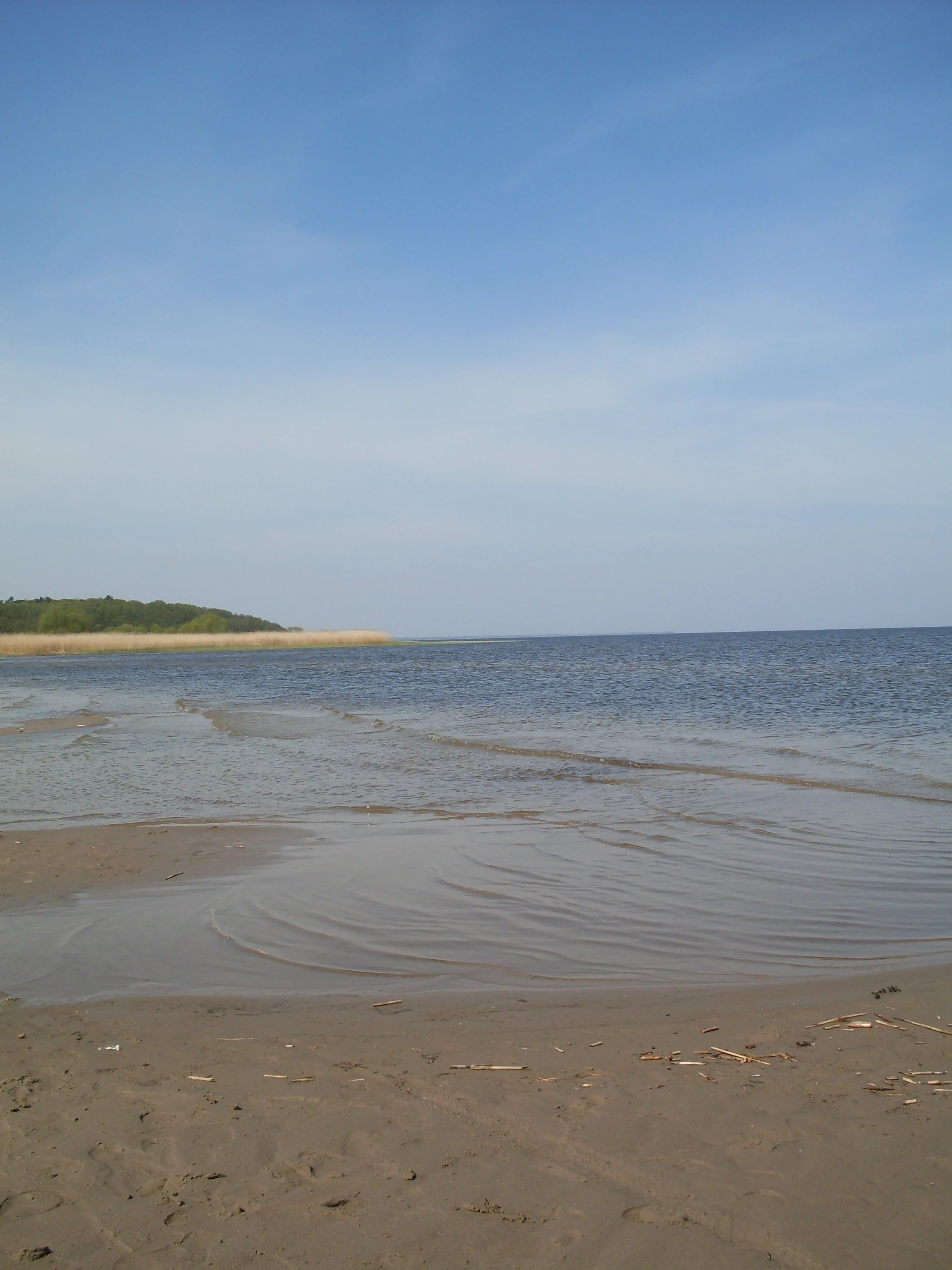
A sandy shoreline leading into a large, calm lagoon under a clear blue sky, with a reed-lined coast visible in the distance.
A view of the Szczecin Lagoon shoreline at Trzebiez.

Ujście Odry i Zalew Szczeciński history and protected-area timeline

Ujście Odry i Zalew Szczeciński was formally designated in 2008 as part of Poland's contribution to the European Natura 2000 network. Its creation reflected the broader process of identifying Polish stretches of the Oder estuary and Szczecin Lagoon as significant for EU-level habitat and species protection.

The site was established as an area of Community Importance under the Habitats Directive, with a proposed upgrade to a Special Area of Conservation. Over time, its boundaries were framed to align with overlapping Special Protection Areas designated under the Birds Directive, effectively building an integrated framework for both habitat and bird conservation across the Oder estuary and connected lagoons.

The inclusion of the pre-existing nature reserves Czarnocin and Białodrzew Kopicki within the site's boundaries shows how the Natura 2000 designation built upon earlier Polish nature protection instruments, layering EU-level recognition on top of longstanding domestic reserve protection.

Ujście Odry i Zalew Szczeciński landscape and geographic character

The protected area captures a layered estuarine and coastal landscape shaped by the Oder River as it approaches the Baltic Sea. Near Szczecin, the river fans out into the Roztoka Odrzańska, a broad, branching river mouth with islands such as Długi Ostrów, before the system transitions into the much larger Szczecin Lagoon. This lagoon, bordered by the Polish coast and the German island of Usedom, forms the central landscape feature and dominates the site's geography.

North of the Szczecin Lagoon, the Dziwna strait connects the system to the Kamieński Lagoon, and ultimately to the open Pomeranian Bay. Wolin and Usedom, two of the largest islands in the area, frame the lagoons and contribute sandy beach, dune, and cliff coastlines, while Chrząszczewska Island adds a smaller island unit within the lagoon system.

Away from the coast, the site extends into the lowland plains of the Lower Oder Valley, the Wkrzańska Plain, and the Goleniowska Plain. These are predominantly flat, low-lying areas crossed by river channels, tributaries, and depressions, providing the terrestrial counterpart to the lagoon-dominated coastal zone and reinforcing the site's character as a transition between freshwater lowlands and brackish Baltic waters.

Ujście Odry i Zalew Szczeciński ecosystems, habitats, and plant life

Ecologically, Ujście Odry i Zalew Szczeciński is defined by its coastal lagoon complex. The dominant habitat type, coastal lagoons (habitat 1150 under the EU Habitats Directive), extends across roughly 42,000 hectares and gives the site its core identity. Surrounding habitats include river channels, estuarine waters, lowland plains, and coastal sections of Wolin and Usedom, producing a wide ecological gradient from freshwater-influenced channels to fully marine conditions.

Beyond the lagoon habitat, the site includes a further 18 natural habitat types, which collectively add structural diversity through reedbeds, salt-influenced vegetation, sandy and muddy shorelines, and patches of woodland. The protected animal component (14 species under the Habitats Directive) reflects this habitat variety, with the conservation focus clearly tilted toward species associated with estuarine, lagoon, and coastal environments.

Ujście Odry i Zalew Szczeciński wildlife and species highlights

The site's wildlife value is closely linked to its estuarine and lagoon habitats and to the overlapping bird protection areas that cover most of its surface. Waterbirds are a central conservation theme, and the integrated Natura 2000 framework treats the lagoons, Dziwna strait, and adjacent lowlands as a coherent bird protection landscape under the designations Zalew Szczeciński, Łąki Skoszewskie, and Zalew Kamieński i Dziwna.

The 14 animal species protected under the Habitats Directive within the site span estuarine and coastal-dependent fauna, including fish and other aquatic groups tied to the brackish transitional waters of the Oder estuary and Szczecin Lagoon. The combination of freshwater inflow from the Oder and the lagoon's connection to the Baltic creates productive feeding and resting conditions for both resident and migratory species, making the wider complex important on a regional scale for waterbird populations of the southern Baltic.

Ujście Odry i Zalew Szczeciński conservation status and protection priorities

From a conservation perspective, Ujście Odry i Zalew Szczeciński is significant because it anchors European-level habitat and species protection to one of the largest brackish lagoon systems on the Polish Baltic coast. Its scale, dominated by 42,000 hectares of protected lagoons, gives it an outsized role in safeguarding habitat 1150 within Poland's Natura 2000 network.

The site also demonstrates a layered conservation model. The Natura 2000 habitat designation (PLH320018) is reinforced by three overlapping Special Protection Areas under the Birds Directive and by two traditional Polish nature reserves, Czarnocin and Białodrzew Kopicki. This stacking of EU instruments with national reserves means the area benefits from multiple legal protection regimes addressing habitat integrity, species conservation, and bird population protection simultaneously.

Its position within five physical-geographical mesoregions, including the Lower Oder Valley and the islands of Wolin and Usedom, also makes it ecologically strategic: it protects not only a single habitat but the transitional gradients between river, lagoon, island, and open coast, each of which supports distinct ecological processes.

Top sights and standout views in Ujście Odry i Zalew Szczeciński

Ujście Odry i Zalew Szczeciński stands out for combining an enormous coastal lagoon habitat with overlapping bird protection areas and traditional nature reserves. The Oder Roztoka near Szczecin, the Szczecin Lagoon, the Dziwna strait, and the Kamieński Lagoon together create one of the most complete estuarine-lagoon gradients along the southern Baltic coast. The presence of Wolin, Usedom, and Chrząszczewska Island adds an island dimension rarely matched in other Polish Natura 2000 sites, while the site's integration with Woliński Park Narodowy and Puszcza Wkrzańska in the wider landscape strengthens its role as a regional conservation anchor.

Monthly climate preview

Long-term monthly temperature averages and precipitation measurements for Ujście Odry i Zalew Szczeciński

Ujście Odry i Zalew Szczeciński Climate Normals, Annual Temperature and Precipitation Patterns

Measured coordinates track monthly temperature variations from winter minimums to summer maximums alongside consistent precipitation rates throughout the annual cycle. Reviewing the complete twelve-month climatology dataset reveals detailed statistical normals across the entire representative point.
Annual mean9 °C
1 °C19 °C
Jan
Feb
Mar
Apr
May12°
Jun16°
Jul19°
Aug19°
Sep15°
Oct10°
Nov
Dec
Warmest month
August

18.8 °C

Coolest month
January

0.7 °C

Wettest month
July

2.5 mm/day

Driest month
April

1.2 mm/day

Park location guide

Geography guide, regional context, and park location map for Ujście Odry i Zalew Szczeciński

Ujście Odry i Zalew Szczeciński park geography, regions, and map view in Poland

Understand where Ujście Odry i Zalew Szczeciński sits in Poland through a broader geographic reading of the surrounding landscape, nearby location context, and its mapped position within the national park landscape.

How Ujście Odry i Zalew Szczeciński fits into Poland

Poland, officially the Republic of Poland, is a Central European country spanning from the Baltic Sea in the north to the Carpathian Mountains in the south. It borders Germany, Czech Republic, Slovakia, Ukraine, Belarus, Lithuania, and Kaliningrad Oblast. The country has a temperate climate, diverse landscapes, and is known for its rich history, cultural heritage, and strong economic position within the EU.

Wider geography shaping Ujście Odry i Zalew Szczeciński in Poland

Poland occupies 312,696 km2 in Central Europe, extending from the Baltic Sea coast in the north to the Sudetes and Carpathian Mountains in the south. It borders Germany to the west, Czech Republic and Slovakia to the south, Ukraine and Belarus to the east, and Lithuania and Kaliningrad Oblast to the northeast. The landscape includes lowland plains, uplands, and mountain ranges.

Map view of Ujście Odry i Zalew Szczeciński

Use this park location map to pinpoint Ujście Odry i Zalew Szczeciński in Poland, understand its exact geographic position, and read its mapped placement within the surrounding landscape more clearly.

Pigeon | © OpenStreetMap contributors

Location context for Ujście Odry i Zalew Szczeciński

Zachodniopomorskie

Visual reference collection showcasing coastal lagoons and estuarine habitats

Ujście Odry i Zalew Szczeciński Photos and Landscape Scenery

Visual documentation captures the expansive coastal lagoons, branching river mouths, and brackish waters defining Ujście Odry i Zalew Szczeciński. Detailed photography reveals the unique transition zones between freshwater discharge and the Baltic Sea.

A sandy shoreline leading into a large, calm lagoon under a clear blue sky, with a reed-lined coast visible in the distance.

A wide, horizontal view of a broad river estuary with calm, dark water in the foreground and a line of green trees and grasslands along the horizon under an overcast sky.

Park atlas

Compare adjacent estuarine habitats and regional Baltic coast reserves

Parks Near Ujście Odry i Zalew Szczeciński and Connected Protected Landscapes

Browse protected areas near Ujście Odry i Zalew Szczeciński to examine neighboring coastal lagoons and lowland river ecosystems. Geographic comparison reveals broader regional conservation patterns across the surrounding West Pomeranian terrain.
Protected areaZachodniopomorskie
Park boundaries overlap#1 closest

Southeast

Łąki Skoszewskie Protected Area: Geography, Mapped Terrain, and Wetland Landscapes

Coastal marshland and bird sanctuary in Zachodniopomorskie

Located along the Szczecin Lagoon, Łąki Skoszewskie consists of extensive wet meadows, alder carrs, and Scots pine forests. This protected area provides a detailed look at the hydrological networks and coastal transition zones that define the unique natural landscape of northwestern Poland.

Area
90.834 km²
Established
2004
Relief
Lowland
Climate
Temperate
A soft watercolor painting depicting a calm shoreline with rolling hills and trees in the distance.
Nature reservePoland
Park boundaries overlap#2 closest

North

Ostoja na Zatoce Pomorskiej: Mapping the Pomeranian Bay Marine Nature Reserve

Extensive marine protected landscape in the Baltic Sea

Ostoja na Zatoce Pomorskiej encompasses over 243,000 hectares of the southern Baltic Sea, serving as a primary marine nature reserve for the Polish coast. The sanctuary is defined by complex underwater features such as shallow sandy banks, gravel plains, and the prominent Odrzańska Ławica, which collectively support essential migratory waterbird populations and protected aquatic species within the European ecological network.

Area
2,430.59 km²
Established
2009
Relief
Lowland
Scope
Marine
Protected areaZachodniopomorskie
Mapped location lies within the park boundary#3 closest

East

Park Natury Zalewu Szczecińskiego: Protected Coastal Landscape and Regional Geography Atlas

A pioneer in active Natura 2000 conservation and lagoon habitat preservation

Situated in the West Pomeranian region, Park Natury Zalewu Szczecińskiego covers a mosaic of coastal pastures, reed-bordered lagoons, and pine forests. This protected area stands out for its active management approach, integrating traditional grazing into a modern conservation model that sustains the biological integrity of the Szczecin Lagoon shorelines and adjacent woodland mosaics.

Area
40 km²
Established
2005
Relief
Lowland
Scope
Mixed
A horizontal watercolor painting showing rolling green hills and a dense forest line against a pale, light-colored sky background.
Protected landscapeWest Pomeranian Voivodeship
Park boundaries overlap#4 closest

Southeast

Puszcza Goleniowska Protected Landscape: Geographic Profile and Mapped Boundaries

A large-scale lowland forest complex in West Pomeranian Voivodeship.

Puszcza Goleniowska represents a critical protected woodland in Poland, spanning 630 square kilometers of post-glacial plains. This forest complex is characterized by its pine-dominated canopy, widespread bog and marshland habitats, and a series of rivers and lakes that form the backbone of its regional drainage. The area encompasses numerous nature reserves and Natura 2000 sites, offering a comprehensive look at the lowland ecological structure of the West Pomeranian Voivodeship.

Area
630 km²
Established
1349
Relief
Lowland
Climate
Temperate
Watercolor painting depicting mountains, rivers, and green terrain
National parkWest Pomeranian Voivodeship
Park boundaries overlap#5 closest

North

Wolin National Park: Coastal Protected Landscape and Glacial Terrain in West Pomeranian Voivodeship

Explore Poland's first marine national park and its dynamic geography.

Wolin National Park offers a profound look into Poland's protected coastal geography. This national park in the West Pomeranian Voivodeship is distinguished by its high sea cliffs, inclusion of Baltic Sea and Szczecin Lagoon waters as Poland's first marine protected area, and a landscape sculpted by glacial moraines. Discover the park's complex delta systems, ancient forests, and the mapped terrain that supports significant bird migration, providing a rich focus for atlas exploration.

Area
109.37 km²
Established
1960
IUCN
II
Visitors
1.5M annual
National parkZachodniopomorskie Voivodeship
Park boundaries overlap#6 closest

North

Woliński Park Narodowy: Atlas Overview of Protected Coastal and Marine Environments

Examining moraine landscapes and marine park boundaries.

Woliński Park Narodowy stands as a critical protected area in the Zachodniopomorskie Voivodeship, blending terrestrial moraine ridges with marine ecosystems. This atlas entry provides geographic context for its coastal cliffs, inland lake district, and the expansive river delta that supports rare avian species.

Area
109.37 km²
Established
1960
Visitors
1.5M annual
Relief
Upland
Protected areaWest Pomeranian Voivodeship
Park boundaries overlap#7 closest

Northeast

Wybrzeże Trzebiatowskie Protected Area: Coastal Wetlands and Baltic Shoreline Map

A diverse wetland corridor in the West Pomeranian Voivodeship.

Wybrzeże Trzebiatowskie represents a significant stretch of the Baltic coastline, characterized by a narrow and elongated geographic profile. The protected landscape highlights a complex interplay of lagoon lakes, river floodplains, and classic dune systems, providing critical habitat within the broader West Pomeranian regional geography.

Area
317.576 km²
Established
2007
Relief
Lowland
Scope
Mixed
Protected areaZachodniopomorskie
1.8 km away#8 closest

South

Police - kanały Protected Area: Mapping Industrial Infrastructure and Ecological Conservation in Zachodniopomorskie

Underground hibernation habitats on the Równina Wkrzańska plain

Police - kanały is an unusual protected area in northern Poland defined by four kilometers of subterranean canals. These industrial remnants provide essential winter habitat for regional bat populations, marking a rare intersection between human-built heritage and biological conservation within the flat lowland plains of the Zachodniopomorskie region.

Area
1.121 km²
Established
2008
Relief
Lowland
Scope
Terrestrial

Common questions about visiting, size, designation, and location context for Ujście Odry i Zalew Szczeciński

Ujście Odry i Zalew Szczeciński FAQs for park facts, access, geography, and protected area context

Find quick answers about Ujście Odry i Zalew Szczeciński, including protected-area facts, park geography, trail and visitor context, and how the park fits into its surrounding country and regional landscape.
MoriAtlas Explorer

Continue Your Protected Areas Search Across the Global Atlas

Deepen your exploration by continuing the structured search for national parks and protected areas worldwide. Utilize the comprehensive filtering capabilities to compare different conservation landscapes and refine your understanding of global park geography. Discover more about the distribution and characteristics of protected natural areas.

Global natural geography