Mori Atlas logo
State or regional parkUrugua-í Provincial Park

Tracing the mapped boundaries and watershed landscapes of this vital Atlantic forest reserve

Urugua-í Provincial Park: A Comprehensive Geographic Atlas of Misiones Province Protected Forests

(Parque Provincial del Urugua-í Doctor Luis Honorio Rolón)

Urugua-í Provincial Park serves as a critical protected landscape in northern Misiones Province, spanning 84,000 hectares of rolling hills and dense riverine basins. As a key segment of the Alto Paraná Atlantic forest, the terrain encompasses both river valleys and the foothills of the Sierra de la Victoria range. This mapped expanse links directly to international conservation corridors, providing a significant habitat for diverse flora and fauna within the Argentine subtropical geography.

subtropical forestAtlantic forestMisionesprotected watershedriver basinImportant Bird Area

Urugua-í Provincial Park

State or regional park

Park overview

Structured park overview, official facts, and landscape profile for Urugua-í Provincial Park

Urugua-í Provincial Park park facts, protected area profile, and essential visitor context

Review the core facts for Urugua-í Provincial Park, including designation, size, terrain, visitor scale, habitats, and operating context in one park-focused overview.

About Urugua-í Provincial Park

Urugua-í Provincial Park occupies one of the most strategic positions for subtropical forest conservation in South America. Sitting in the extreme north of Misiones, it abuts the southeast corner of Iguazú National Park, effectively merging with that park to create a transboundary forested expanse that also borders Brazil's Iguaçu National Park. The result is the largest contiguous block of protected Alto Paraná Atlantic forest remaining on the continent, covering well over a million hectares when counted across all three reserves.

Within this enormous ecoregional context, Urugua-í protects the upper catchment of the Urugua-í River, including the slopes of the Sierra de la Victoria, which forms a watershed divide between the Iguazú and Urugua-í river systems. The terrain shifts from gently rolling plains in the west to more mountainous relief in the north and east, supporting a varied mosaic of vegetation types, including remnant patches of Paraná pine in the southwest.

The climate is humid subtropical and rainy year-round, with annual precipitation along the river ranging from about 1,800 millimeters at its mouth to around 2,000 millimeters near Bernardo de Irigoyen. Cold snaps can bring frosts for roughly five months of the year. These conditions support an exceptionally diverse biota, from stream-dependent amphibians and fish to canopy-dwelling birds and large forest mammals. Beyond its ecological role, Urugua-í also carries a strong cultural and institutional identity as the first Argentine protected area explicitly created to mitigate the environmental impacts of a hydroelectric dam.

Quick facts and research context for Urugua-í Provincial Park

Urugua-í Provincial Park lies in northern Misiones Province, Argentina, spanning territory within the municipalities of Comandante Andresito, San Antonio, and Bernardo de Irigoyen. Its IUCN protected-area category is II, the same category used for national parks, and it is administered by the Subsecretariat of Ecology of Misiones.

At roughly 84,000 hectares, Urugua-í is the third largest protected area of the Alto Paraná Atlantic forests, after the Argentine and Brazilian sections of Iguaçu. The park protects the upper basin of the Urugua-í River and the slopes of the Sierra de la Victoria, and is recognized by BirdLife International as an Important Bird Area for Argentina.

Protection and recognition

Examine the documented terrestrial protection framework and management scope for Urugua-í Provincial Park.

Urugua-í Provincial Park Protection Status and Conservation Recognition Data

Urugua-í Provincial Park maintains a documented terrestrial protection scope within the regional conservation network. Review the verified designation records and international recognition frameworks associated with this protected landscape.

Protection details

Protection scope
Terrestrial
Transboundary protection
No
Park context

Deeper park guide and search-rich context for Urugua-í Provincial Park

Urugua-í Provincial Park history, landscape, wildlife, and travel context

Explore Urugua-í Provincial Park through its history, landscape character, ecosystems, wildlife, conservation priorities, cultural context, and seasonal travel timing in a structured park guide built for atlas discovery and search intent.

Why Urugua-í Provincial Park stands out

Urugua-í is best known for safeguarding a major block of Alto Paraná Atlantic forest directly adjacent to Iguazú National Park, extending the largest continuous protected swath of this critically endangered ecoregion across the Argentine-Brazilian border. The park is also widely recognized for its exceptional bird richness, which has earned it Important Bird Area status in Argentina, and for harboring rare and threatened mammals such as jaguar, giant anteater, bush dog, and South American tapir within a single, ecologically connected landscape.

Urugua-í Provincial Park history and protected-area timeline

The protection story of Urugua-í begins in 1982, when provincial decree 1539 established the Islas Malvinas Provincial Park covering about 10,037 hectares in the Urugua-í River basin. This reserve was notable as Argentina's first officially designated nature reserve, marking an early institutional step toward formal protection of the Misiones forests.

In 1988, provincial decree 339 expanded the protected footprint dramatically, adding roughly 74,000 hectares and laying the groundwork for a much larger conservation unit. On 5 October 1990, provincial law 2794 formally created the present Urugua-í Provincial Park, consolidating the earlier reserve into a single 84,000-hectare protected landscape focused on the Urugua-í River basin.

The new park was conceived explicitly as ecological compensation for the environmental damage caused by the construction of the Urugua-í Dam, which had flooded roughly 8,800 hectares of forest in the lower river basin. By creating a large forested reserve upstream of the dam, the province sought to offset losses of habitat, maintain watershed functions, and preserve the biological integrity of the river system above the reservoir.

Today, Urugua-í is recognized as a critical node in the proposed Trinational Biodiversity Corridor, which aims to maintain forest connectivity among protected areas in Argentina, Brazil, and Paraguay across the Upper Paraná ecoregion. It has also been formally recognized as an Important Bird Area for Argentina under BirdLife International criteria.

Urugua-í Provincial Park landscape and geographic character

The landscape of Urugua-í Provincial Park is shaped by the transition between the Paraná plateau and the broader Misiones uplands. The western parts of the park are gently rolling, with broad valleys carved by the Urugua-í River and its tributaries. Toward the north and east, the terrain rises into the foothills of the Sierra de la Victoria, a mountain range that crosses the north-southeast portion of the park and acts as a watershed divide between the Iguazú and Urugua-í river systems.

The Urugua-í River itself flows through the southern part of the park in a southeast to northwest direction, with its tributaries draining the surrounding hills. Downstream of the park, the river is impounded by the Urugua-í Dam, an engine of both the regional energy supply and the conservation history of the area. Precipitation is abundant and well distributed, feeding persistent streams and supporting the dense forest cover that cloaks nearly every slope.

This combination of lowland river valleys and hill country creates a varied topography across the protected area, allowing elevational differences, slope exposures, and drainage patterns to generate a mosaic of forest types. As a result, the park presents a layered visual profile, from flat-bottomed gallery forests along the rivers to steeper, mist-prone forest stands climbing the slopes of the Sierra de la Victoria.

Urugua-í Provincial Park ecosystems, habitats, and plant life

The park lies entirely within the Alto Paraná Atlantic forests ecoregion, a humid subtropical forest system of exceptional biodiversity and high endemism that is also one of the most threatened forest biomes in South America. Within Urugua-í, the vegetation is varied and structurally complex, covering both the alluvial valleys and the hill country of the Sierra de la Victoria.

Remnant stands of Paraná pine, a once widespread conifer now reduced to scattered populations across the southern portion of the park, coexist with typical inland Atlantic forest species such as palo rosa, laurel negro, laurel amarillo, anchico, cedro, guatambú blanco, loro blanco, and guayubira. The understory includes heart-of-palm, tree ferns, and dense tangles of bamboo, contributing to the multilayered character of the canopy and creating niches for a broad range of animal life.

The network of rivers and streams supports freshwater ecosystems, with dozens of fish species, including several endemics tied to either the Iguazú or Urugua-í basins. Amphibians are particularly well represented in the moist forest-floor environment, and the varied topography combined with year-round humidity allows terrestrial, arboreal, and aquatic species to coexist within relatively short distances.

Urugua-í Provincial Park wildlife and species highlights

Urugua-í supports one of the most intact mammalian faunas remaining in the Argentine Atlantic forest, with around 77 mammal species recorded across 26 families. Among the most ecologically significant are large species that require extensive forest blocks: the jaguar, the South American tapir, the white-lipped peccary, and the collared peccary. Other notable mammals include the giant anteater, the bush dog, and several smaller carnivores such as the margay and the ocelet, along with two species of brocket deer.

The park's avifauna is exceptionally rich, with several hundred bird species documented, including a long list of globally threatened and near-threatened species. Forest-dwelling raptors such as the harpy eagle and the grey-bellied hawk nest in the mature canopy, while large cracids such as the bare-faced curassow forage on the forest floor. A wide range of parrots and macaws, including the blue-winged macaw, the blue-bellied parrot, and the red-spectacled amazon, reflect the importance of large fruiting trees. The park is regionally important for the conservation of the black-fronted piping guan, and also hosts rare species such as the Brazilian merganser along the riverine habitats.

Reptiles and amphibians are well represented, with around three dozen amphibian species and nearly thirty reptile species combining to fill the moist forest niches of streams, leaf litter, and canopy. Insect diversity is also notable, with hundreds of insect species documented, including a wide assemblage of butterflies whose presence underscores the structural and floral complexity of the underlying forest.

Urugua-í Provincial Park conservation status and protection priorities

Urugua-í Provincial Park occupies a central place in the conservation of the Alto Paraná Atlantic forests, an ecoregion that has lost the vast majority of its original extent to logging, agriculture, and colonization. By protecting roughly 84,000 hectares of contiguous forest and merging functionally with the adjoining Iguazú National Park, Urugua-í helps secure one of the last landscape-scale blocks of this biome in Argentina.

The park was explicitly designed as compensatory conservation for the Urugua-í Dam, which flooded more than 8,000 hectares of forest downstream. Establishing a major protected area upstream of the dam was meant to mitigate habitat loss, preserve watershed services, and protect the ecological integrity of the broader river basin. In this sense, Urugua-í is also one of the earliest Argentine examples of using formal protected-area creation to offset the environmental footprint of large infrastructure.

Its conservation value extends beyond national borders. Urugua-í is a cornerstone of the proposed Trinational Biodiversity Corridor, which would connect protected forests across Argentina, Brazil, and Paraguay, and has been recognized by BirdLife International as an Important Bird Area for Argentina. Together with Iguazú National Park and Brazil's Iguaçu National Park, it forms the largest continuous protected remnant of this endangered forest ecoregion, making it disproportionately important for the long-term survival of forest-dependent species such as jaguar, tapir, harpy eagle, and black-fronted piping guan.

Urugua-í Provincial Park cultural meaning and human context

Urugua-í's institutional identity reflects a strong regional conservation tradition in Misiones Province, where provincial authorities have played a leading role in safeguarding the remaining Atlantic forest. The park was formally named in honor of Doctor Luis Honorio Rolón, recognizing his contribution to conservation and provincial environmental policy.

The park also sits within a landscape shaped by hydroelectric development, rural colonization, and forestry, and its creation is closely tied to the social and economic history of northern Misiones. By compensating for the impacts of the Urugua-í Dam, the reserve embodies an early provincial effort to balance energy infrastructure with the protection of forests and river systems that sustain local communities, indigenous heritage, and traditional land uses in the region.

Top sights and standout views in Urugua-í Provincial Park

Urugua-í's standout features include its sheer size as one of the three largest protected Alto Paraná Atlantic forest blocks, its direct functional connection with Iguazú National Park across the international border context, and its role as an Important Bird Area hosting threatened species such as the black-fronted piping guan, harpy eagle, and Brazilian merganser.

Equally notable is the park's unusual origin as an ecological compensation project for a hydroelectric dam, its inclusion in the proposed Trinational Biodiversity Corridor linking Argentina, Brazil, and Paraguay, and its elevation profile, which spans gently rolling lowlands along the Urugua-í River to hill country in the Sierra de la Victoria.

Best time to visit Urugua-í Provincial Park

The park's subtropical, year-round rainy climate means that there is no fully dry season, so visitors should expect humid conditions whenever they come. Cooler months, generally corresponding to the southern winter and early spring, can bring frosts for roughly five months of the year and offer milder temperatures for hiking and wildlife observation along the trails.

Spring and early summer bring rising temperatures and increased insect activity, particularly along lowland trails, while the warmer months also concentrate much of the bird activity around fruiting trees and river edges. Cooler, drier-leaning windows tend to be more comfortable for walking the interpretive trails around the Uruzu Ranger Station and for spotting mammals and birds in the more open parts of the forest.

Monthly climate preview

Long-term representative measurements and monthly climate patterns for Urugua-í Provincial Park

Urugua-í Provincial Park Climate Normals, Annual Temperature and Precipitation

Urugua-í Provincial Park displays recorded average temperatures ranging from mild winter lows to warm summer peaks alongside steady precipitation across the twelve-month cycle. Reviewing the complete monthly climate dataset provides deeper statistical context regarding long-term temperature ranges and precipitation distributions.
Annual mean22 °C
16 °C26 °C
Jan26°
Feb26°
Mar25°
Apr22°
May18°
Jun16°
Jul16°
Aug18°
Sep20°
Oct22°
Nov24°
Dec26°
Warmest month
January

26.3 °C

Coolest month
July

15.7 °C

Wettest month
October

7.3 mm/day

Driest month
August

2.7 mm/day

Park location guide

Geography guide, regional context, and park location map for Urugua-í Provincial Park

Urugua-í Provincial Park park geography, regions, and map view in Argentina

Understand where Urugua-í Provincial Park sits in Argentina through a broader geographic reading of the surrounding landscape, nearby location context, and its mapped position within the national park landscape.

How Urugua-í Provincial Park fits into Argentina

Argentina is a federal republic located in the southern cone of South America, bordering Chile, Bolivia, Paraguay, Brazil, Uruguay, and the Atlantic Ocean. With an area of 2,780,085 km², it is the second-largest country in South America and the eighth-largest globally. The capital and largest city is Buenos Aires, and the official language is Spanish. The country claims sovereignty over the Falkland Islands, South Georgia and the South Sandwich Islands, and a portion of Antarctica.

Wider geography shaping Urugua-í Provincial Park in Argentina

Argentina occupies the southern portion of South America, sharing the Southern Cone region with Chile to the west. The country borders Bolivia and Paraguay to the north, Brazil to the northeast, Uruguay and the South Atlantic Ocean to the east, and the Drake Passage to the south. The Andes mountain range runs along the western border, while the Pampas plains dominate the central region. Argentina also claims territories in Antarctica.

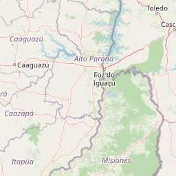
Map view of Urugua-í Provincial Park

Use this park location map to pinpoint Urugua-í Provincial Park in Argentina, understand its exact geographic position, and read its mapped placement within the surrounding landscape more clearly.

Pigeon | © OpenStreetMap contributors

Location context for Urugua-í Provincial Park

Misiones Province
Park atlas

Compare surrounding forest reserves and regional sanctuaries in northeastern Argentina

Explore Parks Near Urugua-í Provincial Park and Connected Protected Landscapes

Visitors exploring Urugua-í Provincial Park can continue browsing adjacent protected areas and connected forest reserves across the Misiones uplands. Comparing nearby parks reveals broader regional conservation patterns within the Atlantic forest ecoregion.
National parkMisiones Province
Park boundaries overlap#1 closest

Northwest

Iguazú National Park: Argentina's Misiones Province Protected Landscape Atlas

Explore mapped boundaries and regional geography.

Iguazú National Park serves as a key protected natural area situated within Misiones Province. This MoriAtlas entry details its mapped geographic boundaries, contributing essential context for understanding its landscape identity. Users can explore how this national park fits into the regional geography, providing a factual basis for detailed atlas-based study of protected lands and their unique terrain.

Area
677 km²
Established
1934
IUCN
II
Relief
Lowland
Natural monumentAlto Paraná Department
About 40 km away#2 closest

West

Moisés Bertoni Scientific Monument: Protected Atlantic Forest in Alto Paraná, Paraguay

Natural monument and historic research landscape

Explore the geographic footprint of Moisés Bertoni Scientific Monument, an essential protected area in the Alto Paraná Department. This site safeguards mature Atlantic Forest ecosystems along the Paraná River while preserving the historic research station and cultural legacy of its founder. The monument remains a pivotal landmark for understanding the biodiversity and conservation landscape of eastern Paraguay.

Area
1.99 km²
Established
1955
Relief
Lowland
Climate
Subtropical
National parkParaguay
About 44 km away#3 closest

West

Ñacunday National Park National Park: Paraguay's Protected Landscape and Mapped Boundaries

Explore its unique geography and protected terrain.

Gain a precise understanding of Ñacunday National Park, a designated national park in Paraguay. This entry focuses on its role as a protected landscape, detailing its geographic attributes and mapped boundaries. It serves as a vital resource for users seeking specific information on the park's natural terrain and its contribution to Paraguay's conservation geography, facilitating structured discovery within the atlas.

Area
20 km²
Established
1993
Relief
Mixed relief
Climate
Subtropical
Wildlife reserveAlto Paraná Department
About 59 km away#4 closest

Northwest

Tatí Yupí Refuge: Wildlife Reserve Geography and Paraná River Landscape

A 2,245 hectare protected biological forest in Alto Paraná

Tatí Yupí Refuge offers a unique perspective on protected land management within the Itaipu hydroelectric complex. Explore the mapped boundaries, basaltic stream formations, and subtropical forest habitat that define this essential ecological refuge in Paraguay's Alto Paraná Department.

Area
22.45 km²
Established
1982
Relief
Lowland
Climate
Subtropical
State or regional parkMisiones Province
About 74 km away#5 closest

South

Esmeralda Provincial Park: Protected Forest Landscapes and Geography in Misiones

A critical node in the Alto Parana Atlantic forest ecosystem

Esmeralda Provincial Park represents a significant protected area within the Misiones Province, acting as a core unit for the Yaboti Biosphere Reserve. The terrain is characterized by dense subtropical forest and rugged topography shaped by the Yaboti Guazu drainage network. This area serves as a primary site for forest biodiversity research, highlighting the ecological value of continuous, undisturbed forest tracts within the broader Argentine Mesopotamia region.

Area
316.19 km²
Established
1997
IUCN
II
Relief
Upland
A soft watercolor illustration depicting a serene landscape with rolling green hills, scattered trees, and a winding stream under a warm, light-colored sky.
Wildlife reserveCanindeyú Department
About 151 km away#6 closest

North

Refugio Carapá Wildlife Reserve: Mapping Biological Diversity in Canindeyú Department

A protected sub-tropical mosaic along the Paraná River basin

Refugio Carapá protects a dramatic stretch of mountain slopes and riverine valleys in the Department of Canindeyú. By managing a mosaic of tall forests, swamps, and open camp vegetation, the reserve maintains a crucial ecological link within the wider Itaipu reservoir landscape. The area functions as a research-focused environment dedicated to preserving native flora and threatened species in eastern Paraguay.

Area
32.5 km²
Established
1984
Relief
Mountain
Climate
Subtropical
National parkItapúa Department
About 153 km away#7 closest

Southwest

San Rafael National Park: National Park Protected Landscape & Geographic Overview

Discover the mapped boundaries and regional setting in Itapúa.

San Rafael National Park is a significant protected area designated as a national park in Paraguay's Itapúa Department. This page serves as an atlas-centric entry point, offering a detailed view of its geographic scope, mapped park boundaries, and its role as a conservation landscape. Users can explore the park's terrain and its place within the regional geography for a structured understanding of its protected status.

Area
693.04 km²
Established
1992
IUCN
II
Relief
Upland
A soft watercolor illustration of a landscape with green grassy fields in the foreground, calm water in the midground, and gentle rolling hills in the background under a pale, pinkish sky.
Nature reserveCanindeyú Department
About 218 km away#8 closest

Northwest

Mbaracayú Forest Nature Reserve: A Detailed Geographic Atlas of Paraguay's Protected Forest

Mapped terrain, forest corridors, and landscape features

Spanning over 64,000 hectares in the Canindeyú Department, Mbaracayú Forest Nature Reserve preserves the core of the Alto Paraná Atlantic forest. The area features a complex mosaic of subtropical forest, riparian corridors, and the undulating slopes of the Cordillera de Mbaracayú range. This map-focused profile details the reserve's unique topography, stream networks, and its vital role as a continuous wilderness block in eastern Paraguay.

Area
644.05 km²
Established
1991
IUCN
II
Relief
Upland

Common questions about visiting, size, designation, and location context for Urugua-í Provincial Park

Urugua-í Provincial Park FAQs for park facts, access, geography, and protected area context

Find quick answers about Urugua-í Provincial Park, including protected-area facts, park geography, trail and visitor context, and how the park fits into its surrounding country and regional landscape.
MoriAtlas Explorer

Continue Your Protected Areas Search Across the Global Atlas

Deepen your exploration by continuing the structured search for national parks and protected areas worldwide. Utilize the comprehensive filtering capabilities to compare different conservation landscapes and refine your understanding of global park geography. Discover more about the distribution and characteristics of protected natural areas.

Global natural geography