

Mori Atlas logo
Protected areaValley of the Lakes

A transitional landscape of saline lake chains, barchan dunes, and arid steppe plains between the Khangai and Gobi-Altai ranges.

Valley of the Lakes: Mapping the Intermontane Basin and Protected Wetlands of Southwestern Mongolia

(Valley of Lakes (Ramsar designation))

The Valley of the Lakes forms a vast intermontane depression spanning 500 kilometers across southwestern Mongolia. This protected area serves as a critical wetland complex where seasonal, saline lakes fluctuate across sandy and rocky plains, offering vital staging grounds for migratory waterfowl. The basin bridges the forested slopes of the Khangai Mountains to the north and the arid expanse of the Gobi-Altai to the south, creating a unique ecological transition zone.

intermontane basinsaline lakeswetlandsRamsar sitesteppesalt marsh

Valley of the Lakes

Protected area

Park overview

Structured park overview, official facts, and landscape profile for Valley of the Lakes

Valley of the Lakes park facts, protected area profile, and essential visitor context

Review the core facts for Valley of the Lakes, including designation, size, terrain, visitor scale, habitats, and operating context in one park-focused overview.

About Valley of the Lakes

The Valley of the Lakes is one of Mongolia's defining geographical features, a sweeping lowland corridor that threads between two of the country's major mountain ranges. In the north rise the Khangai Mountains, a forested, water-rich system that sends seasonal rivers southward into the valley, while to the south stand the drier ridges of the Gobi-Altai. Between these two worlds lies a 500-kilometer-long depression, around 100 kilometers wide, that functions as both a hydrological and ecological boundary.

At elevations between 1000 and 1400 meters above sea level, the valley carries the visual character of a true steppe-to-desert transition. Sandy and rocky plains dominate the surface, while solonchak, naturally salt-encrusted soils, and takir, hard-crusted clay-rich soils typical of arid Central Asia, shape the chemistry of the basin. In places along the valley margins, crescent-shaped barchan sand dunes advance across the plains, emphasizing the arid character of the southern reaches.

The hydrology of the valley is dominated by a chain of lakes that vary in size, depth, and salinity. The largest of these, Böön Tsagaan Lake and Orog Lake, are joined by several smaller water bodies, all of them generally shallow with a saucer-shaped depth profile. Water levels shift significantly with both summer evaporation and interannual climate variability, meaning that some lakes may occasionally disappear entirely in dry years. Their inflow comes almost entirely from rivers emerging from the Khangai to the north; the Gobi-Altai contributes no permanent flow.

Ecologically, the valley serves as a critical rest stop for migratory waterfowl, including Anatidae species such as geese, swans, and ducks, and various shorebirds that depend on the lakes as they move across Asia. As the lakes recede during the warm months, they expose salt marsh habitats that support feeding and staging concentrations of birds. The surrounding waters also host a distinctive fish fauna, notably Oreoleuciscus species and Thymallus brevirostris, a grayling endemic to western Mongolia, giving the valley additional ecological significance beyond its birdlife.

Quick facts and research context for Valley of the Lakes

Located in Bayankhongor Province in southwestern Mongolia, the Valley of the Lakes is a long intermontane depression separating the Khangai and Gobi-Altai mountain systems. The valley is roughly 500 kilometers long, approximately 100 kilometers wide, and lies at elevations between 1000 and 1400 meters above sea level, creating a transitional landscape between forested mountains and arid steppe.

Its terrain consists of sandy and rocky plains with characteristic solonchak and takir soils, while barchan sand dunes line parts of the valley margin. A chain of shallow saline lakes, including Böön Tsagaan Lake and Orog Lake, occupies the floor of the valley and is sustained primarily by rivers originating in the Khangai Mountains. The full valley region was designated a Ramsar Wetland of International Importance in 1998.

Protection and recognition

Documented terrestrial protection history and Ramsar site recognition

Valley of the Lakes Protection Status and International Recognition Data

Valley of the Lakes holds a terrestrial protection designation established in 1998 alongside official Ramsar wetland recognition. Exploring these records highlights the documented conservation history and administrative background associated with the protected landscape.

International recognition

Protection details

Protection scope
Terrestrial
Designated year
1998
Transboundary protection
No
Park context

Deeper park guide and search-rich context for Valley of the Lakes

Valley of the Lakes history, landscape, wildlife, and travel context

Explore Valley of the Lakes through its history, landscape character, ecosystems, wildlife, conservation priorities, cultural context, and seasonal travel timing in a structured park guide built for atlas discovery and search intent.

Why Valley of the Lakes stands out

The Valley of the Lakes is best known for its long chain of shallow, saline lakes set within a wide, arid intermontane basin. These lakes, especially Böön Tsagaan and Orog, fluctuate seasonally and from year to year, sometimes drying out completely and leaving behind broad salt marsh areas that concentrate migratory birds along the Central Asian flyway. The valley is also recognized for its distinctive combination of steppe plain, salt crust soils, and barchan sand dunes along the margins, all set between two major mountain systems. This unusual ecological transition zone, combined with its Ramsar designation, makes the valley a key regional landmark for wetland conservation in Mongolia.

Valley of the Lakes history and protected-area timeline

The Valley of the Lakes first entered the Western scientific record through the explorations of the Russian geographer Nikolay Przhevalsky, whose late nineteenth-century expeditions across Central Asia helped define the understanding of Mongolia's interior landscapes. His surveys of the valley's lakes, plains, and mountain margins contributed to early geographical knowledge of the region and remain a foundational reference point in the documentation of this area.

In modern conservation history, the defining milestone came on 6 July 1998, when the full valley region, encompassing Böön Tsagaan Lake, Taatsin Tsagaan Lake, Adgiin Tsagaan Lake, and Orog Lake, was formally designated a Ramsar Wetland of International Importance. This international recognition placed the valley within a global network of wetlands of significant ecological value and underscored its role as a habitat for migratory waterfowl in Central Asia.

The proximity of the Gobi-Altai also gives the valley a notable place in seismological history: the region experienced the 1957 Mongolia earthquake, a major event associated with this active tectonic margin. While primarily an ecological and hydrological feature, the valley thus sits within a landscape shaped by both slow geological processes and sudden earth movements.

Valley of the Lakes landscape and geographic character

The Valley of the Lakes occupies a classic intermontane basin, a long depression sandwiched between two major mountain systems. To the north, the Khangai range rises with forested, water-bearing slopes, while to the south the Gobi-Altai presents a drier, more broken mountain front. The valley floor between them stretches roughly 500 kilometers in length and around 100 kilometers in width, sitting between 1000 and 1400 meters above sea level.

The surface of the valley is composed primarily of sandy and rocky plains. The soils carry the signature of semi-arid and arid conditions, with extensive solonchak formations where salts accumulate at the surface, and takir soils forming hard, cracked crusts across clay-rich flats. These soil types give the basin its characteristic high-salinity hydrology and influence the kinds of lakes and marshes that develop within it.

The valley margins are decorated with barchan sand dunes, crescent-shaped dunes shaped by prevailing winds, which serve as a visual reminder of the region's arid, desert-adjacent character. Toward the Gobi-Altai, the landscape becomes seismically active, and the 1957 Mongolia earthquake's epicenter fell within this transition zone, marking the area as both climatically and geologically dynamic.

Valley of the Lakes ecosystems, habitats, and plant life

The ecological identity of the Valley of the Lakes is defined by its character as a saline wetland complex embedded within a semi-arid steppe basin. The lake chain along the valley floor creates a gradient from open water to salt marsh, with seasonal drying exposing broad mudflats and crusty salt flats that become biologically productive habitats in their own right.

Vegetation across the broader valley reflects the arid to semi-arid climate, with sparse steppe and shrubby cover across sandy and rocky plains, and salt-tolerant plant communities around the lake margins. The soils themselves, especially solonchak and takir types, support specialized plant assemblages adapted to high salinity and periodic moisture.

The valley's ecosystems form a transition between the forested northern Khangai slopes and the desert-steppe environment that extends toward the Gobi-Altai. This positioning makes it a meeting point of faunal ranges, a place where steppe, wetland, and semi-desert species overlap, and where migratory species intersect with resident Central Asian wildlife.

Valley of the Lakes wildlife and species highlights

The Valley of the Lakes is most widely recognized for its significance as a staging area for migratory waterfowl. Large numbers of Anatidae, the family that includes ducks, geese, and swans, pass through the valley's lakes, particularly Böön Tsagaan and Orog, while various shorebird species use the receding shorelines as feeding and resting habitat.

The dynamic nature of the lakes, which shrink and expand dramatically through the year, plays an important role in shaping the birdlife of the region. As water levels drop in the warmer months, exposed salt marsh edges concentrate feeding opportunities and make the valley a predictable stopover for birds moving along Central Asian flyways.

Beyond birds, the valley supports a regionally distinctive fish fauna. Species of Oreoleuciscus, a genus of cyprinid fish adapted to Central Asian inland waters, inhabit the lakes and connecting rivers, alongside Thymallus brevirostris, a grayling species endemic to western Mongolia. The presence of these regionally endemic fish underscores the conservation importance of the valley's aquatic systems, not just its birdlife.

Valley of the Lakes conservation status and protection priorities

The Valley of the Lakes holds formal international recognition as a Ramsar Wetland of International Importance, a designation awarded in 1998 that places it within a global framework for wetland protection. The Ramsar listing covers the full valley region, including Böön Tsagaan Lake, Taatsiin Tsagaan Lake, Adgiin Tsagaan Lake, and Orog Lake, reflecting the integrated ecological value of the entire lake chain rather than any single water body.

Its conservation importance lies in its role as a refuge and staging ground for migratory waterfowl in a part of Asia where large, ecologically functional wetlands are increasingly rare. The valley's combination of seasonal freshwater inflows from the Khangai, naturally saline lake chemistry, and salt marsh exposures creates a mosaic of habitats that supports a wide variety of bird and fish species, some of which are regionally endemic.

The dynamic and at times precarious nature of the lakes, which can dry out partially or entirely in some years, also gives the conservation context a sense of urgency. Climate variability and changing water availability across Central Asia make the valley's future hydrology a key concern for long-term wetland management in Mongolia.

Valley of the Lakes cultural meaning and human context

The Valley of the Lakes sits within a region shaped by centuries of nomadic pastoralism, where herding communities have long moved seasonally between the Khangai Mountains and the drier Gobi margins. The chain of lakes and the surrounding steppe have historically provided water and grazing resources for these traditional land uses, though the area today is best known primarily through scientific exploration and conservation recognition rather than dense human settlement.

The valley's place in geographical history is anchored by the late nineteenth-century expeditions of Nikolay Przhevalsky, whose surveys brought international scientific attention to the lakes and surrounding plains. This legacy of exploration continues to shape how the valley is referenced in both Russian and international geographic literature, alongside more recent conservation designations.

Top sights and standout views in Valley of the Lakes

The Valley of the Lakes stands out for the sheer length and ecological coherence of its lake chain, running through a 500-kilometer intermontane depression between the Khangai and Gobi-Altai ranges. Its shallow, saline lakes, particularly Böön Tsagaan and Orog, are defining landmarks in southwestern Mongolia, both visually and ecologically.

Equally notable is the valley's combination of habitats: rocky and sandy steppe plains, takir and solonchak soils, barchan sand dunes along the margins, and seasonal salt marsh exposures around the receding lakes. Together, these features make the valley a textbook example of a Central Asian intermontane wetland and a Ramsar site of acknowledged international importance.

Best time to visit Valley of the Lakes

The seasonal character of the Valley of the Lakes is shaped strongly by the behavior of its lakes and the movement of migratory birds. During the warmer months, the lakes shrink and expose extensive salt marsh edges, concentrating waterfowl and shorebirds along accessible shorelines and making this period especially notable for wildlife observation.

Cooler seasons bring higher water levels and broader lake surfaces, altering both the visual character of the valley and the distribution of birds. Spring and autumn migration periods tend to bring heightened bird activity, while the deep cold of the Mongolian winter transforms the lakes into frozen, often snow-covered plains. The most rewarding times for understanding the valley's wetland character tend to align with these transitional seasons, when bird movements and shifting water levels are most pronounced.
Monthly climate preview

Long-term temperature ranges and monthly precipitation averages for Valley of the Lakes

Valley of the Lakes Climate Normals and Annual Weather Patterns

Representative coordinate records show wide annual temperature swings alongside consistently low monthly precipitation values across the protected landscape. Examining the full twelve-month profile reveals detailed long-term averages for each seasonal phase.
Annual mean4 °C
-15 °C22 °C
Jan-15°
Feb-11°
Mar-2°
Apr
May14°
Jun20°
Jul22°
Aug20°
Sep13°
Oct
Nov-5°
Dec-14°
Warmest month
July

22.4 °C

Coolest month
January

-15.3 °C

Wettest month
July

1.2 mm/day

Driest month
January

0.1 mm/day

Park location guide

Geography guide, regional context, and park location map for Valley of the Lakes

Valley of the Lakes park geography, regions, and map view in Mongolia

Understand where Valley of the Lakes sits in Mongolia through a broader geographic reading of the surrounding landscape, nearby location context, and its mapped position within the national park landscape.

How Valley of the Lakes fits into Mongolia

Mongolia is a landlocked sovereign state in East Asia, known for its vast steppe landscapes, nomadic culture, and historical significance as the heartland of the Mongol Empire founded by Genghis Khan in 1206. The country has a population of approximately 3.5 million people and is the world's most sparsely populated sovereign state. Ulaanbaatar is the capital and largest city, home to roughly half the population.

Wider geography shaping Valley of the Lakes in Mongolia

Mongolia is located in East Asia, landlocked between Russia to the north and China to the south. The country occupies the Mongolian Plateau and features diverse terrain including grassy steppe, mountains in the north and west, and the Gobi Desert in the south. It covers 1,564,116 km2, making it the second largest landlocked country in the world.

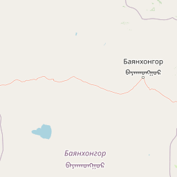
Map view of Valley of the Lakes

Use this park location map to pinpoint Valley of the Lakes in Mongolia, understand its exact geographic position, and read its mapped placement within the surrounding landscape more clearly.

Pigeon | © OpenStreetMap contributors

Location context for Valley of the Lakes

Bayankhongor Province
Park atlas

Compare surrounding regional geography and connected protected landscapes

Other Parks and Protected Areas Near Valley of the Lakes

Browse national parks and protected areas located near Valley of the Lakes to examine broader regional geography and transitional ecosystems. This comparison view helps trace intermontane wetland basins and mountain boundaries across the wider surrounding territory.
National parkMongolia
About 44 km away#1 closest

Southeast

Ikh Bogd Uul National Park: Explore Mongolia's Protected Landscape and Geography

Discover mapped terrain and protected area context.

Ikh Bogd Uul National Park offers a unique window into Mongolia's protected landscapes. This page delves into the park's specific geographic setting, its mapped boundaries, and its character as a national park. Users can explore the foundational data for understanding its natural terrain and its role within the country's conservation atlas, providing a concrete basis for geographic discovery and appreciating the scope of protected areas in the region.

Area
2,629 km²
Established
2008
IUCN
II
Relief
Mountain
Wildlife reserveÖvörkhangai Province
About 119 km away#2 closest

East

Taatsiin Tsagaan Lake Wildlife Reserve: Mapped Landscapes and Wetland Conservation in Övörkhangai Province

A critical saline wetland node within the Gobi Desert ecosystem.

Taatsiin Tsagaan Lake represents a substantial inland saline water body, defined by its role as an Important Bird Area and key wetland habitat. As part of the Valley of the Lakes, this wildlife reserve demonstrates the ecological significance of arid-land basins. Explore its geographic boundaries and position within the broader Gobi Desert landscape to understand its value in regional avian conservation.

Area
252 km²
Established
1998
Relief
Lowland
Climate
Arid
National parkÖmnögovi Province
About 212 km away#3 closest

Southeast

Gobi Gurvansaikhan National Park: National Park Protected Landscape and Geographic Atlas

Mapped terrain and regional geography of this Mongolian protected area.

Navigate the atlas-focused details of Gobi Gurvansaikhan National Park, a key protected area situated in Ömnögovi Province. This entry provides essential geographic context, detailing the park's mapped boundaries and its role within the regional landscape. Understand the distinct terrain and environmental geography that define this Mongolian national park, offering a structured foundation for atlas-based discovery and learning about conservation landscapes.

Area
27,000 km²
Established
1993
IUCN
II
Relief
Mountain
National parkMongolia
About 237 km away#4 closest

Northeast

Khangai Nuruu National Park: Discover Mongolia's Protected Mountain Landscape and Atlas Context

Explore mapped boundaries and diverse ecosystems across its terrain.

Khangai Nuruu National Park stands as a vast national park in central Mongolia, characterized by its diverse protected landscapes and significant geographic scope. Spanning the Khangai Mountains, it presents a remarkable ecological transition from alpine meadows and taiga forests to steppe and riparian environments. This park offers a rich atlas exploration opportunity, highlighting its mapped boundaries and the unique regional geography that defines its protected status, making it a key point of discovery for understanding Mongolian conservation areas.

Area
8,885 km²
Established
1996
IUCN
II
Relief
Mountain
Nature reserveÖmnögovi Province
About 247 km away#5 closest

South

Tost Tosonbumba Nature Reserve: Mapping the Protected Mountain Landscapes of the South Gobi

A rugged desert-mountain ecosystem within Ömnögovi Province

Tost Tosonbumba Nature Reserve provides a critical protected corridor of steep ravines, rocky spurs, and cliff faces set against the vast gravel plains of the South Gobi Desert. This atlas entry examines the physical boundaries and ecological terrain that define this protected landscape, illustrating its distinct position within the regional geography of Ömnögovi Province in southern Mongolia.

Area
7,284 km²
Established
2016
Relief
Mixed relief
Water
Minor water
Nature reserveMongolia
About 307 km away#6 closest

Southwest

Great Gobi A Strictly Protected Area: Geographic Map and Nature Reserve Overview

Exploring the arid Gobi Desert terrain in southwestern Mongolia

This extensive nature reserve in southwestern Mongolia acts as a cornerstone for desert conservation. Gain insight into its vast, unpopulated desert steppe, the harsh continental climate that shapes its topography, and its role as a final refuge for rare species within the broader Gobi ecosystem.

Area
46,369 km²
Established
1975
Relief
Lowland
Climate
Arid
A minimalist watercolor painting showing a soft, hazy landscape of green rolling hills and distant mountains bordering a light-colored lake.
National parkArkhangai Province
About 318 km away#7 closest

North

Khorgo-Terkhiin Tsagaan Nuur National Park: Volcanic Terrain and Lake Geography

A protected highland landscape in Arkhangai Province

Explore the distinct physical geography of Khorgo-Terkhiin Tsagaan Nuur National Park, where the extinct Khorgo volcano borders a vast freshwater lake. This protected area offers a look at the mosaic of birch forest and alpine slopes within the Khangai range. The mapping of this central Mongolian site reveals how volcanic activity and mountain hydrology converge to shape its unique natural horizon.

Relief
Mountain
Climate
Alpine
Scope
Terrestrial
Water
Water-dominated
National parkMongolia
About 321 km away#8 closest

North

Khorgo-Terkhiin Tsagaan Nuur National Park: A Volcanic Landscape and Wetland Atlas

Mapping volcanic terrain and migratory bird habitats in the Khangai Mountains.

This protected area features the dramatic remnants of the Taryatu-Chulutu volcanic field, centered on the extinct Khorgo volcano and the deep waters of Terkhiin Tsagaan Lake. The park provides an essential refuge for avian populations in its western marshlands, contrasting with the surrounding forest steppe. Explore the unique topography and ecological boundaries of this significant Mongolian conservation landscape.

Area
8 km²
Established
1965
IUCN
II
Relief
Mountain

Common questions about visiting, size, designation, and location context for Valley of the Lakes

Valley of the Lakes FAQs for park facts, access, geography, and protected area context

Find quick answers about Valley of the Lakes, including protected-area facts, park geography, trail and visitor context, and how the park fits into its surrounding country and regional landscape.
MoriAtlas Explorer

Continue Your Protected Areas Search Across the Global Atlas

Deepen your exploration by continuing the structured search for national parks and protected areas worldwide. Utilize the comprehensive filtering capabilities to compare different conservation landscapes and refine your understanding of global park geography. Discover more about the distribution and characteristics of protected natural areas.

Global natural geography