
Mori Atlas logo
Nature reserveVasière des Badamiers

Understanding the ecological boundaries, tidal mudflat terrain, and regional coastal geography

Vasière des Badamiers Nature Reserve: Mapping the Coastal Wetlands of Petite-Terre, Mayotte

Vasière des Badamiers serves as a critical intertidal ecosystem on the western edge of Petite-Terre. This protected landscape features a distinct basin of fine sediment and mangroves that filters local waters before they reach the wider lagoon. As a vital stopover for migratory waterbirds and a breeding ground for rare species, the site illustrates the complex intersection of natural wetland habitat and modern coastal infrastructure in Mayotte.

wetlandmudflatmangrovecoastal lagoonRamsar sitewaterbirds
A flat-style digital illustration of a mountain valley with steep cliffs, evergreen trees, a flowing river, and multiple waterfalls under a pale sun.

Vasière des Badamiers

Nature reserve

Park overview

Structured park overview, official facts, and landscape profile for Vasière des Badamiers

Vasière des Badamiers park facts, protected area profile, and essential visitor context

Review the core facts for Vasière des Badamiers, including designation, size, terrain, visitor scale, habitats, and operating context in one park-focused overview.

About Vasière des Badamiers

The Vasière des Badamiers occupies a narrow coastal strip on the western edge of Petite-Terre, Mayotte's smaller inhabited island. Geologically, the basin was shaped by the formation of a double tombolo linking Petite-Terre to larger neighboring landforms, creating a low-energy pocket of shallow water that accumulates fine sediments. An older reef ridge, now buried in mud, partially encloses the basin and shields it from the full force of the open lagoon, while still allowing seawater exchange through natural breaches. The result is a hybrid environment that mixes freshwater inputs from inland catchments with marine water from the lagoon, producing a brackish lagoon-mudflat complex that is rare in this part of the Indian Ocean.

Ecologically, the Vasière des Badamiers punches well above its weight. Its open water, tidal flats, and mangrove fringes together form a refuge for migratory waterbirds at a regional scale, serving as a critical node within the broader ecological corridor of the Comoros archipelago. Beyond its birdlife, the site is also an important nursery and feeding area for a wide range of marine life, including fish, crustaceans, mollusks, and sea turtles, all drawn to the rich productivity of its shallow, nutrient-rich sediments.

What makes the Vasière des Badamiers especially distinctive, however, is its location immediately adjacent to one of the most urbanized parts of Mayotte. The neighboring Badamiers industrial zone and the Petite-Terre port exert constant pressure on the wetland, yet the mudflat simultaneously acts as a natural buffer, filtering terrestrial runoff and urban effluents before they reach the open lagoon. This combination of high biodiversity, tight urban proximity, and regulatory recognition under the Ramsar Convention gives the site a special place in Mayotte's network of protected areas.

Quick facts and research context for Vasière des Badamiers

The Vasière des Badamiers is a small coastal lagoon-mudflat ecosystem on Petite-Terre in Mayotte, covering roughly 125 hectares and managed by the Conservatoire de l'espace littoral et des rivages lacustres. Classified under IUCN Category IV as a habitat and species management area, it has held Ramsar status since 2011. The site lies within the commune of Dzaoudzi, near the towns of Dzaoudzi and Labattoir, and forms part of the ecological corridor linking Mayotte to the rest of the Comoros archipelago.

Protection and recognition

Explore documented Ramsar site designations and official recognition history.

Vasière des Badamiers Protection Status and International Recognition Records

Vasière des Badamiers maintains documented recognition records through established Ramsar wetland designations originating from two thousand and two. Structured conservation data details the official protected area framework and international status assigned to this wetland ecosystem.
Park context

Deeper park guide and search-rich context for Vasière des Badamiers

Vasière des Badamiers history, landscape, wildlife, and travel context

Explore Vasière des Badamiers through its history, landscape character, ecosystems, wildlife, conservation priorities, cultural context, and seasonal travel timing in a structured park guide built for atlas discovery and search intent.

Why Vasière des Badamiers stands out

The Vasière des Badamiers is best known as a Ramsar-recognized refuge for waterbirds in an otherwise urbanized coastal setting. Its shallow, brackish waters and fringe of mangrove create a feeding and resting ground for migratory waders, terns, and other seabirds traveling along the western Indian Ocean flyway. The mudflat is also notable for hosting a breeding population of the endangered Humblot's heron and for its unusual intertidal spider fauna, giving the small site an outsized ecological importance for the Comoros region.
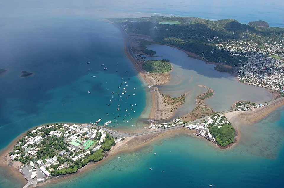
Aerial view looking down at a coastal mudflat and wetland area, bordered by a road, town structures, and the ocean with several small boats.
An aerial view of the Vasière des Badamiers mudflat and the surrounding coastline of Petite-Terre in Mayotte.

Vasière des Badamiers history and protected-area timeline

The Vasière des Badamiers was formally established as a protected area in 2002. In 2011, it was designated as a Ramsar site of international importance under the Convention on Wetlands, becoming site number 2002 in France's national Ramsar inventory. The wetland has long been used informally by local residents, but its modern protection reflects growing awareness of its regional importance for migratory waterbirds and of its role in buffering coastal water quality. In 2010, the Conservatoire du littoral created an on-site discovery trail to help local residents and visitors engage with the site, recognizing that public awareness and active local stewardship would be essential to its long-term protection given the encroaching urban and industrial pressure.

Vasière des Badamiers landscape and geographic character

The landscape of the Vasière des Badamiers is defined by the interplay between tidal flats, mangrove, and rocky shoreline. The site forms a shallow coastal basin bounded on one side by an old reef ridge, now silted up, which separates the wetland from the wider lagoon. A double tombolo, the geological link of sediment and rock that connects Petite-Terre to adjacent landmasses, frames the overall setting and concentrates the calm, shallow waters needed for mud accumulation.

At low tide, broad expanses of fine, dark sediment are exposed, while higher tides bring brackish water back across the basin and through narrow breaches into the lagoon. Patches of mangrove line parts of the shore, with their roots emerging from the soft substrate and creating structured habitat along the tidal gradient. The presence of the industrial zone and the nearby port along the water's edge introduces an unusual urban-industrial edge to what is otherwise a soft, natural coastal landscape, making the visual contrast between wetland and city a defining aspect of the site's character.

Vasière des Badamiers ecosystems, habitats, and plant life

Ecologically, the Vasière des Badamiers is a transitional environment where freshwater, seawater, and terrestrial influences converge. The basin receives freshwater from inland catchments and saline water from the surrounding lagoon, producing brackish conditions that support communities adapted to fluctuating salinity and tidal cycles. The mangrove fringe along the shore contributes organic matter to the mud, fueling a productive soft-bottom habitat beneath the shallow water.

At a broader scale, the wetland sits within the ecological corridor that links Mayotte to the rest of the Comoros archipelago, providing one of the few sheltered, food-rich stopovers for migratory species in the region. The combination of open water, exposed mudflat, and mangrove creates a layered habitat mosaic where different species can occupy feeding, roosting, and breeding niches, and where seasonal changes in tide and rainfall continually reshape the ecological balance.

Vasière des Badamiers wildlife and species highlights

The Vasière des Badamiers is best known for its abundant and diverse waterbird community. The mudflat is a refuge for numerous shorebirds and seabirds, including migratory terns, waders, and other species that follow the broader Indian Ocean flyway. It also serves as a critical breeding and feeding area for Humblot's heron, an endangered species endemic to the Comoros region whose persistence relies heavily on the conservation of sites like this one.

Beneath the water and across the tidal flats, the wetland supports a wide range of marine and intertidal fauna, including sea turtles, fish, crustaceans, and mollusks that exploit the brackish, nutrient-rich conditions. The site is also notable for hosting Idioctis intertidalis, the so-called Badamiers spider, one of only three tarantula species known from Mayotte and a striking example of the site's capacity to shelter species found nowhere else in easily accessible terms. Together, this blend of birds, marine life, and unique invertebrates makes the Vasière a regionally significant wildlife site despite its compact size.

Vasière des Badamiers conservation status and protection priorities

From a conservation perspective, the Vasière des Badamiers is one of the most significant wetlands in the Comoros archipelago. Its Ramsar designation recognizes its international value for migratory waterbirds, while its inclusion in the Mayotte Marine Natural Park extends protection across the surrounding marine environment. The site is managed by the Conservatoire du littoral, which acquired and oversees the property in order to maintain its ecological functions, and is classified as an IUCN Category IV area focused on habitat and species management.

Beyond its biodiversity role, the mudflat performs a crucial ecosystem service by filtering runoff and urban effluents before they reach the lagoon, helping reduce sedimentation and nutrient loading in the broader marine park. The site's conservation is therefore tightly linked to the management of nearby urban and industrial pressures, and to the engagement of the local population through educational trails and outreach.

Vasière des Badamiers cultural meaning and human context

The Vasière des Badamiers is deeply integrated into daily life on Petite-Terre. Local residents of Dzaoudzi and Labattoir have long used the shoreline and its margins, and the wetland continues to act as a nearby natural space for an urban community. The 2010 discovery trail built by the Conservatoire du littoral is a recognition that its long-term protection depends not only on formal legal status but also on the relationship between the population and this shared coastal landscape, which sits at the meeting point of ordinary Mahorais life and an internationally important natural area.

Top sights and standout views in Vasière des Badamiers

The standout qualities of the Vasière des Badamiers include its Ramsar-recognized status as a refuge for migratory waterbirds, its rare combination of mangrove, mudflat, and brackish lagoon habitat on Petite-Terre, and its critical role as a breeding and feeding ground for the endangered Humblot's heron. The site is also notable for its unique intertidal tarantula species, its function as a natural filter for urban runoff before it reaches the lagoon, and its unusual position as a biodiversity hotspot embedded directly within an urban and industrial setting.

Best time to visit Vasière des Badamiers

The Vasière des Badamiers is accessible throughout the year and its character changes markedly with the tides and seasons. Low tide exposes the broad mudflats and brings the greatest concentration of feeding shorebirds and waders, while higher tides push birds toward the mangrove fringes and the open water, often offering different species mixes and behaviors. Dry and wet seasons also shape water levels and sediment exposure, so any season can deliver a distinct view of the wetland, with bird activity generally strong whenever tides expose the flats during daylight hours.
Monthly climate preview

Long term average temperature and monthly precipitation patterns in Mayotte

Vasière des Badamiers Climate Normals and Weather by Month

Representative coordinate records show steady thermal ranges alongside distinct precipitation shifts across the twelve month sequence. Reviewing complete monthly climate normals provides deeper analytical context for this protected landscape.
Annual mean27 °C
25 °C28 °C
Jan28°
Feb28°
Mar28°
Apr28°
May27°
Jun26°
Jul25°
Aug25°
Sep25°
Oct26°
Nov27°
Dec28°
Warmest month
April

28.2 °C

Coolest month
August

24.9 °C

Wettest month
January

8.2 mm/day

Driest month
August

0.4 mm/day

Park location guide

Geography guide, regional context, and park location map for Vasière des Badamiers

Vasière des Badamiers park geography, regions, and map view in France

Understand where Vasière des Badamiers sits in France through a broader geographic reading of the surrounding landscape, nearby location context, and its mapped position within the national park landscape.

How Vasière des Badamiers fits into France

France is a unitary semi-presidential republic and one of the world's largest economies. It borders Belgium, Luxembourg, Germany, Switzerland, Italy, Monaco, Andorra, and Spain, with a maritime border to the United Kingdom. The country is known for its cultural influence, art, cuisine, and political history spanning centuries.

Wider geography shaping Vasière des Badamiers in France

France is located in Western Europe. Metropolitan France extends from the Rhine to the Atlantic Ocean and from the Mediterranean Sea to the English Channel and North Sea. The country borders Belgium, Luxembourg, Germany, Switzerland, Italy, Monaco, Andorra, Spain, and has a maritime border with the United Kingdom.

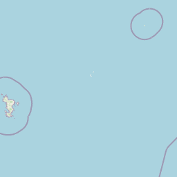
Map view of Vasière des Badamiers

Use this park location map to pinpoint Vasière des Badamiers in France, understand its exact geographic position, and read its mapped placement within the surrounding landscape more clearly.

Pigeon | © OpenStreetMap contributors

Location context for Vasière des Badamiers

Mayotte
Recorded earthquake history

View the Vasière des Badamiers Recorded Earthquake History Catalogue

Explore the historical seismic records associated with the geography of Vasière des Badamiers. This MoriAtlas catalogue provides event details, including magnitude and proximity data, for all earthquakes documented near this protected coastal wetland.

Vasière des Badamiers Earthquake History

Catalogued events

204 events

Strongest magnitude

Magnitude 5.9

Most recent event

Aug 27, 2024

This history includes earthquakes recorded inside the park or within 50 km of its borders

Visual exploration of tidal mudflats, mangrove habitats, and protected wetland terrain

Vasière des Badamiers Photos and Coastal Landscape Scenery

Visual records capture the distinctive intertidal mudflats, mangrove fringes, and brackish waters defining Vasière des Badamiers. Photographic documentation reveals the complex ecological transition zones between urbanized shorelines and protected coastal habitats.

Aerial view looking down at a coastal mudflat and wetland area, bordered by a road, town structures, and the ocean with several small boats.

A wide view of a brown mudflat at low tide, with mangroves and distant hills visible across the water under a blue sky.

Park atlas

Compare coastal wetlands, marine reserves, and regional protected areas

Exploring Parks Near Vasière des Badamiers and Surrounding Protected Landscapes

Users viewing Vasière des Badamiers can browse adjacent coastal wetlands and marine reserves across the surrounding region. Expanding the geographic scope helps connect individual mudflat habitats with broader protected landscapes.
A soft watercolor painting of a calm bay with a small island in the center, surrounded by gentle hills and green coastal land.
Wildlife reserveMayotte
About 20 km away#1 closest

Southwest

Baie de Bouéni Wildlife Reserve: Mapping Coastal Biodiversity and Volcanic Terrain

A protected bay and mangrove system on the coast of Mayotte.

Baie de Bouéni stands as a significant wildlife reserve in Mayotte, framed by the volcanic massifs of Mont Bénara and Mont Choungui. This coastal sanctuary protects the largest mangrove belt in the Comoros and offers a clear example of the meeting of intertidal mudflats and marine ecosystems within the western Indian Ocean.

Area
5.19 km²
Established
2007
IUCN
IV
Relief
Lowland
Protected areaMayotte
About 22 km away#2 closest

Southwest

Pointes et plages de Saziley et Charifou Protected Area Geography and Map Context

Coastal ridgelines, mangrove habitats, and Mayotte island terrain

Delve into the physical geography and protected area configuration of Pointes et plages de Saziley et Charifou. This site presents a striking contrast between steep, dry inland ridges and low-lying coastal mangrove systems, offering an essential look at the complex environmental layering found across the southeastern coast of Mayotte.

Area
6.65 km²
Established
1997
IUCN
IV
Relief
Upland
Watercolor illustration of a mountainous landscape with a lake and grassy fields.
National parkAnjouan
About 110 km away#3 closest

Northwest

Mount Ntringui National Park: Protected Volcanic Landscape and Highland Geography on Anjouan

Explore its dramatic peaks, crater lake, and remnant montane forests.

Mount Ntringui National Park is a significant protected area situated in the rugged volcanic highlands of Anjouan. This national park preserves the island's highest peaks, Mount Ntringui and Mount Trindrini, alongside the unique Dzialandzé crater lake and the crucial Moya Forest. It stands as a vital refuge for endemic species and represents the last substantial tract of montane forest on Anjouan, offering deep insights into the region's unique ecology and mapped natural terrain.

Area
79.14 km²
Established
2010
IUCN
II
Relief
Mountain
National parkAnjouan
About 134 km away#4 closest

Northwest

Shisiwani National Park: Anjouan's Protected Marine and Island Landscape Atlas

Coastal and terrestrial protected area mapping in Comoros.

Delve into the protected landscape of Shisiwani National Park, a critical national park situated on Anjouan's Sima Peninsula in Comoros. This atlas entry details the park's combined marine and terrestrial boundaries, highlighting its vital coral reefs, mangrove forests, and unique island geography. Understand the park's role in conservation through its mapped extent and diverse natural environments, offering a clear geographic context for protected area exploration.

Area
64.97 km²
Established
2016
IUCN
II
Climate
Tropical
National parkComoros
About 176 km away#5 closest

Northwest

Mohéli National Park: Comoros National Park and Protected Landscape Exploration

Mapped geography and protected area identity.

Mohéli National Park is a dedicated national park within the Comoros, providing a specific focus for exploring protected lands and their geographic distribution. This entry details the park's mapped boundaries and its significance as a conservation landscape. Understanding Mohéli National Park offers valuable insight into the regional geography of the Comoros archipelago and its unique natural context.

Area
643.62 km²
Established
2010
Relief
Mixed relief
Climate
Tropical
National parkComoros
About 236 km away#6 closest

Northwest

Karthala National Park: Comoros' Active Volcano and Endemic Protected Landscape

Explore mapped volcanic terrain and unique island biodiversity.

Karthala National Park, situated on Grande Comore, is defined by its active shield volcano, Mount Karthala, the highest peak in the Comoros. This protected area is celebrated for its extraordinary endemism, housing unique bird species and plant life evolved in isolation. The park's dramatic caldera system and sloping volcanic mass present a fascinating geological and ecological landscape, offering critical context for understanding island ecosystems and protected areas in the Indian Ocean.

Area
262.14 km²
Established
2010
Relief
Mountain
Climate
Tropical
National parkGrande Comore
About 242 km away#7 closest

Northwest

Coelacanth National Park: Marine Protected Landscape and Geographic Setting off Grande Comore

Explore the unique marine geography and conservation value.

Coelacanth National Park is a significant marine protected area dedicated to preserving a unique underwater ecosystem surrounding Grande Comore. Its designation as a national park highlights its importance for safeguarding the habitat of the coelacanth, a rare prehistoric fish species. The park's landscape comprises vibrant coral reefs and deep offshore waters, integral to the broader Indian Ocean geography, offering insights into marine conservation and protected areas.

Area
92.76 km²
Established
2010
IUCN
II
Scope
Marine
Watercolor painting of a coastal landscape with green trees, rolling hills, and light water reflections.
Protected areaSofia
About 254 km away#8 closest

South

Anjajavy Forest Protected Area: Landscape Geography and Regional Mapping

Tsingy karst, dry forest, and mangrove ecosystems in Sofia, Madagascar

The Anjajavy Forest protects a unique peninsula defined by the meeting of dry deciduous forest and jagged marine tsingy limestone. Spanning fifty square kilometres, this area is bordered by the Majajamba and Narinda Bays, showcasing an accessible convergence of complex karst topography and coastal mangrove corridors essential for endemic species.

Area
50 km²
Relief
Mixed relief
Climate
Tropical
Scope
Mixed

Common questions about visiting, size, designation, and location context for Vasière des Badamiers

Vasière des Badamiers FAQs for park facts, access, geography, and protected area context

Find quick answers about Vasière des Badamiers, including protected-area facts, park geography, trail and visitor context, and how the park fits into its surrounding country and regional landscape.
MoriAtlas Explorer

Continue Your Protected Areas Search Across the Global Atlas

Deepen your exploration by continuing the structured search for national parks and protected areas worldwide. Utilize the comprehensive filtering capabilities to compare different conservation landscapes and refine your understanding of global park geography. Discover more about the distribution and characteristics of protected natural areas.

Global natural geography