
Mori Atlas logo
Protected areaVembanad

A detailed look at the sprawling brackish lagoon, canal networks, and Kuttanad lowland terrain.

Vembanad Protected Area and Wetland Geography: Mapping India's Largest Inland Waterway System

(Vembanad-Kol Wetland)

Vembanad serves as the central artery for the Kerala backwaters, stretching across multiple districts as a vital wetland system fed by six major rivers. This protected area encompasses a complex mosaic of lagoons, canals, and unique rice fields that sit below sea level. Through detailed mapping, understand the ecological interplay between the Laccadive Sea and the freshwater inflows that sustain resident waterfowl and traditional agricultural landscapes.

wetlandsRamsar sitelakebackwatersKeralabirdwatching
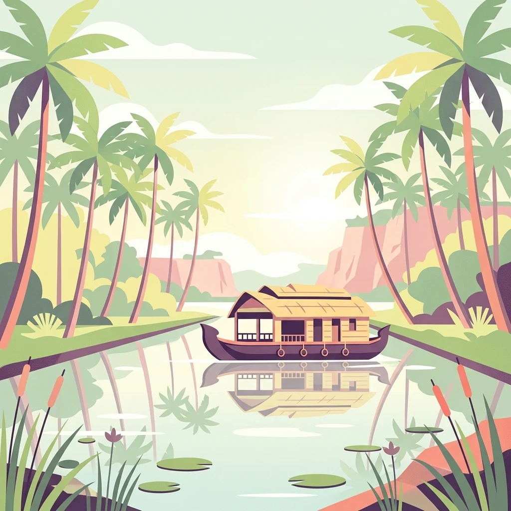
Digital vector illustration of a traditional Kerala houseboat on a canal lined with palm trees.

Vembanad

Protected area

Park overview

Structured park overview, official facts, and landscape profile for Vembanad Lake

Vembanad Lake park facts, protected area profile, and essential visitor context

Review the core facts for Vembanad Lake, including designation, size, terrain, visitor scale, habitats, and operating context in one park-focused overview.

About Vembanad Lake

Vembanad is not a typical inland lake but a vast coastal wetland system that defines the geography of central Kerala. It stretches from Alappuzha in the south to Azheekkode in the north, threading through a landscape of paddy fields, coconut palms, coconut-fringed villages, rivers, and a maze of man-made canals that together form the celebrated Kerala backwaters landscape.

The lake is intimately tied to daily life in Kerala. Its waters support traditional fishing, supply irrigation to the unique below-sea-level paddy fields of Kuttanad, and connect hundreds of villages through inland water transport. Settlements such as Kottayam, Alappuzha, Kochi, Cherthala, Vaikom, and Changanassery all relate to the lake in different ways, and the lake itself changes name and character as it travels through these communities, from Vembanad Lake in the north to Punnamada Lake near Alappuzha and Kochi Lake around the historic port city.

Vembanad's cultural footprint is equally significant. The Nehru Trophy Boat Race, featuring long snake boats or chundan vallams paddled by dozens of rowers, takes place annually on a stretch of the lake and has become a symbol of Kerala's competitive maritime heritage. Houseboats, or kettuvallams, originally used to transport rice and cargo across the backwaters, now carry visitors through this same network, blending traditional craft with one of India's signature tourism experiences.

Ecologically, the lake is among the most important wetlands in India. Designated a Ramsar site in 2002 as the Vembanad-Kol Wetland, it is the largest of Kerala's three international wetlands and supports roughly 20,000 waterfowl. It is also a productive habitat for shrimp and finfish, sustaining both artisanal fisheries and a wider aquatic food web. At the same time, the lake has been heavily modified: large portions of its original water spread have been reclaimed for polders, port expansion around Kochi, and agriculture, while invasive water hyacinth proliferation, pollution hotspots, and altered salinity regimes have all placed the lake under sustained ecological stress.

Quick facts and research context for Vembanad Lake

Vembanad is a brackish-to-fresh coastal lake and wetland system running roughly north-south through Kerala, bordered by Alappuzha, Kottayam, and Ernakulam districts. It is separated from the Arabian Sea by a narrow barrier island and connected to other coastal water bodies by an extensive canal network.

The lake is fed by the major rivers of central Kerala, including the Periyar, Pamba, Achankovil, Manimala, Meenachil, and Muvattupuzha, and drains nearly 40 percent of the state's area. It was designated as a Ramsar site in 2002, identified under India's National Wetlands Conservation Programme, and supports one of the largest waterbird gatherings in India.

Protection and recognition

Documented conservation status, designation year, and international wetland recognition records.

Vembanad Protection Status, Ramsar Wetland Designation, and Official Recognition History

Vembanad holds a mixed protection scope established in 2002 alongside official designation as the Vembanad-Kol Wetland Ramsar site. Structured records outline the documented designation history and recognized international status for the protected area.

International recognition

Protection details

Protection scope
Mixed
Designated year
2002
Transboundary protection
No
Park context

Deeper park guide and search-rich context for Vembanad Lake

Vembanad Lake history, landscape, wildlife, and travel context

Explore Vembanad Lake through its history, landscape character, ecosystems, wildlife, conservation priorities, cultural context, and seasonal travel timing in a structured park guide built for atlas discovery and search intent.

Why Vembanad Lake stands out

Vembanad is best known as the heart of the Kerala backwaters, a long, intricate network of brackish lagoons, canals, and river estuaries that has become iconic for houseboat cruises and shoreline villages. The lake is also famous for hosting the Nehru Trophy Boat Race on Punnamada Lake near Alappuzha, an event that draws attention to Kerala's centuries-old snake boat tradition. Beyond tourism, Vembanad is recognized for the unusual Kuttanad lowlands along its southern edge, one of the rare places in the world where rice cultivation takes place below sea level. The lake also supports more than 20,000 waterfowl, making it one of India's most important wetland bird habitats.
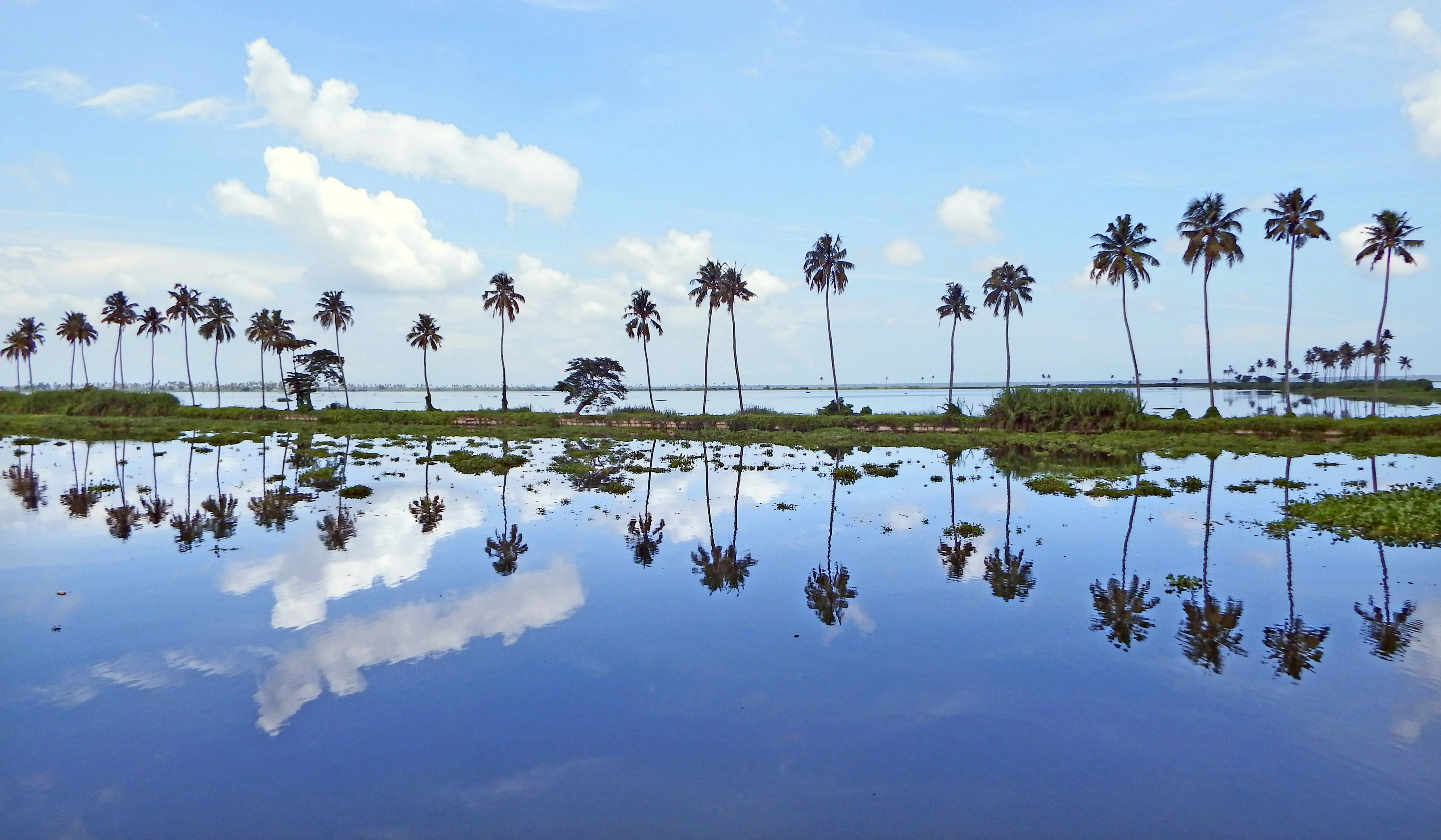
A wide landscape shot of a calm lake reflecting a row of tall palm trees and a blue sky with white clouds. Patches of green aquatic vegetation float on the water surface.
A serene view of Vembanad Lake at Kumarakom, featuring a row of palm trees reflected in the calm water.

Vembanad Lake history and protected-area timeline

Vembanad's modern history is closely tied to the long-running engineering efforts to manage Lake Kuttanad. The lake is believed to have first reached its present overflowing state in 1341, when extreme flooding permanently altered the lowlands. The 20th century brought major interventions, most notably the construction of the Thanneermukkom salt water barrier as part of the Kuttanad Development Scheme, designed to block tidal saltwater intrusion and allow an additional dry-season crop in the below-sea-level paddy fields south of the barrier.

While the barrier brought agricultural gains, it also produced unintended ecological consequences. By physically dividing the lake into a permanent freshwater side and a brackish side, the 1,252-metre Thanneermukkom bund disrupted the natural flushing of the freshwater zone, encouraging rampant water hyacinth growth and limiting the upstream migration of fish and prawns. Meanwhile, the lake steadily shrank, with the water spread area falling from roughly 290 square kilometres in 1917 to around 213 square kilometres by 1990, as polders, agricultural reclamation, and the expansion of Wellington Island for Kochi Port ate into open water.

Recognition of the lake's broader value grew alongside its shrinking. The Vembanad wetland was formally listed under India's National Wetlands Conservation Programme and, in August 2002, designated as a Ramsar Wetland of International Importance under the name Vembanad-Kol Wetland, a turning point that placed the lake within global frameworks for wetland conservation and sustainable use.

Vembanad Lake landscape and geographic character

Vembanad's landscape is shaped by the interplay of river, tide, and human cultivation. The lake sits essentially at sea level and is separated from the Laccadive Sea by a narrow barrier island, creating a long, shallow brackish lagoon whose character changes from freshwater in the south to a more saline environment near Kochi. Reed beds, mangrove patches, open water, narrow canals, and small islets punctuate the shoreline, while submerged and emergent aquatic vegetation defines much of the visible margin.

At its widest, the lake spans roughly 14 kilometres across. Several small islands rise above the water, including Pathiramanal, Perumbalam, Pallippuram, and the cluster of islands around Kochi, such as Vypin, Mulavukad, Maradu, Udayamperoor, Vallarpadam, and the artificial Willingdon Island, which was formed by dredging during the development of the port of Cochin. In the southern reaches, the landscape of the lake blends almost seamlessly with the rice paddies of Kuttanad, a flat expanse where fields, canals, and the lake interlock in a rare below-sea-level mosaic.

Coconut palms and tropical vegetation line much of the shore, giving the backwaters their characteristic look of swaying fronds reflected in still water. In places such as Kumarakom, the shoreline is gentler and more settled, framing the broad lake with small villages and resort properties, while near Alappuzha the lake narrows and flows into Punnamada, where the Nehru Trophy Boat Race is held.
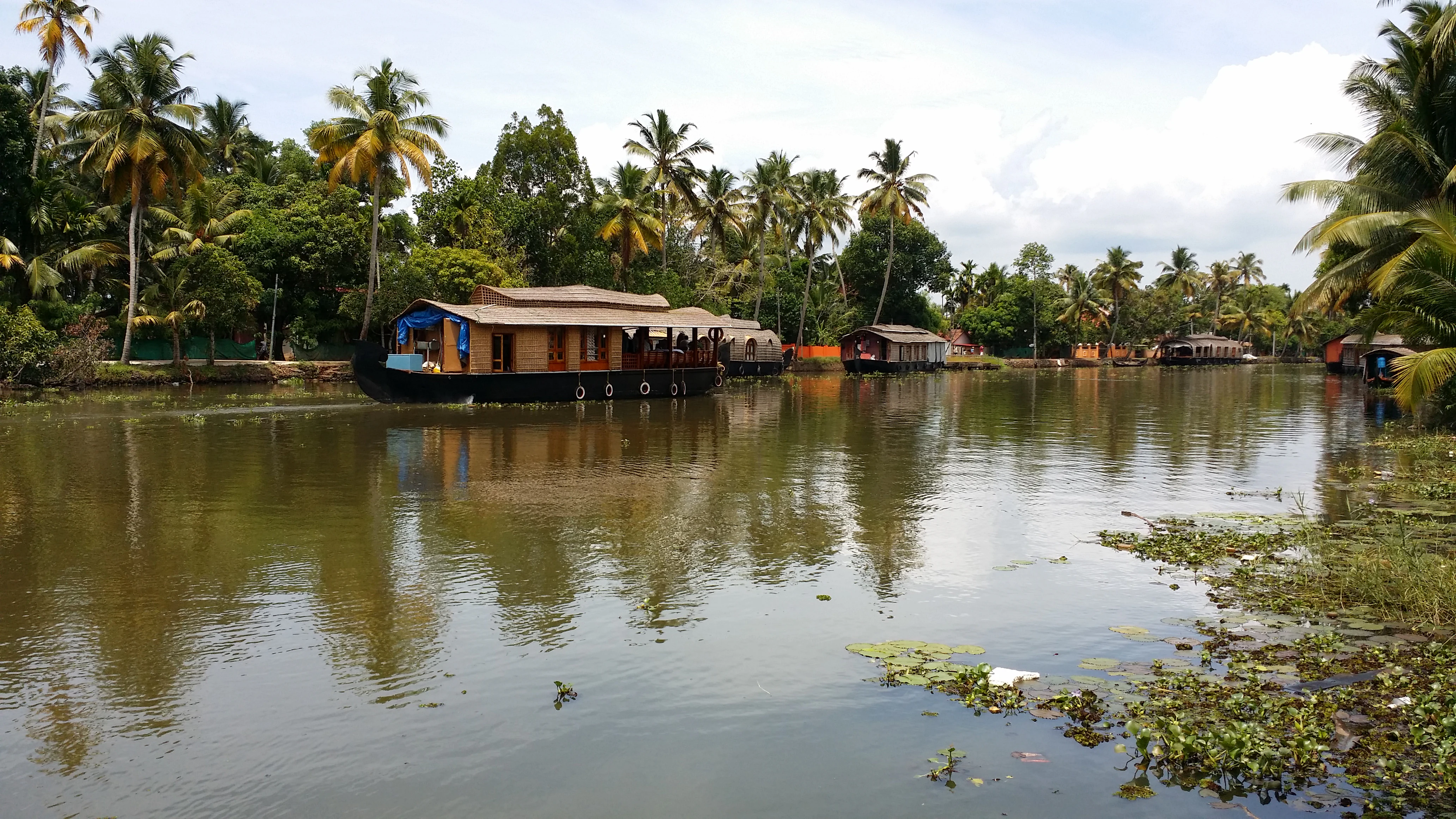
A wide landscape view of a calm lake featuring several long houseboats docked near the shore, with a dense background of coconut palm trees and aquatic plants in the foreground.
Traditional houseboats floating on the calm waters of Vembanad Lake near Kumarakom, framed by coconut palms.

Vembanad Lake ecosystems, habitats, and plant life

Vembanad represents one of the largest and most ecologically complex wetland systems in India. Its mix of brackish and freshwater habitats supports a rich mosaic of aquatic vegetation, fish, invertebrates, and birds, and its hydrology, fed by six major rivers and shaped by tidal exchange through the Kochi outlet, gives it an unusually broad range of ecological niches within a single water body.

The freshwater side of the lake, upstream of the Thanneermukkom bund, is dominated by rooted and floating aquatic plants, including extensive mats of water hyacinth. The brackish portions and tidal creeks host mangroves, salt-tolerant marsh vegetation, and the productive nursery grounds that sustain shrimp and a variety of finfish. The interaction between freshwater inflow and tidal salt flux creates transitional zones that are particularly important for wildlife, especially waterfowl, which concentrate along shallow margins and exposed shallows.

Because the lake drains almost 40 percent of Kerala's land area, it also functions as a regional sink for nutrients and sediments. This makes it both ecologically productive and ecologically vulnerable: the same biological richness that supports fisheries and birdlife can also amplify the effects of pollution and nutrient loading, especially in sheltered bays and near urban centres such as Kochi.

Vembanad Lake wildlife and species highlights

Vembanad is one of India's most significant waterbird sites, hosting more than 20,000 waterfowl, the third-largest concentration in the country. Species typical of large tropical wetlands, including various ducks, herons, egrets, terns, and waders, use the lake as a feeding, roosting, and seasonal staging area. The Kumarakom Bird Sanctuary, located along the eastern shore near Kumarakom village, is a focal point for birdwatchers and showcases part of this wider lake-wide assemblage.

Fish and aquatic invertebrates form another cornerstone of the lake's wildlife. Vembanad is an important habitat for shrimp and supports a diverse finfish community that includes both resident species and migratory visitors moving between the lake and the sea. The seasonal opening of inland waterways during the Onam period, when tradition allows more fishing activity, is closely tied to these migrations, even as modern barriers have altered the timing and scale of fish movement.

Mammals and reptiles are present along the margins, in reed beds, and on the smaller islands, while the lake's islands and shoreline thickets add habitat for a range of smaller bird, reptile, and insect life. Although the lake is not primarily famous for charismatic large mammals, its biodiversity value lies in the scale and connectivity of its wetland habitats rather than in any single flagship species.

Vembanad Lake conservation status and protection priorities

Vembanad's central conservation importance is its status as a Ramsar Wetland of International Importance, designated in 2002 under the name Vembanad-Kol Wetland. This recognition places the lake within a global framework for the conservation and sustainable use of wetlands and underscores its role for migratory and resident waterbirds, fisheries, and broader aquatic biodiversity.

Domestically, the lake has been identified by the Government of India under the National Wetlands Conservation Programme, adding an official layer of national-level attention to its protection. The lake's conservation significance also extends to its hydrological function: it stores and conveys runoff from a substantial portion of Kerala, influences local water quality, and supports a vast traditional fishery that livelihoods across multiple districts depend on.

Despite this recognition, Vembanad faces significant conservation challenges. Historically, more than 60 square kilometres of the original water spread have been reclaimed, mainly for polders and the expansion of Wellington Island for the Port of Cochin, and the lake has shrunk to roughly 37 percent of its former area. Pollution hotspots, particularly near urban and industrial areas, invasive water hyacinth proliferation in the freshwater portion, disrupted fish migration caused by the Thanneermukkom barrier, and continued pressure on lake margins together define the modern conservation agenda for the wetland.

Vembanad Lake cultural meaning and human context

Vembanad is woven deeply into the cultural identity of central Kerala. The lake and its connected backwaters have long supported traditional livelihoods centred on fishing, rice cultivation, coconut farming, and boat-based transport. The rice-growing lowlands of Kuttanad, which sit below sea level along the lake's southern edge, are emblematic of this relationship, blending human ingenuity, communal labour, and a fragile aquatic environment.

The Nehru Trophy Boat Race on Punnamada Lake is the lake's most visible cultural event, bringing together communities from across Kerala in a festival of synchronized rowing on long snake boats, a tradition with roots in the older rivalry between local kingdoms along the waterways. Houseboats, derived from the traditional kettuvallams that once ferried rice and goods, now link this heritage to contemporary tourism, allowing visitors to experience the same routes that historically carried Kerala's trade.

Local place names along the lake, Vembanad, Punnamada, and Kochi Lake, also reflect distinct regional identities within a single water body. Each stretch is associated with its own settlements, customs, dialects, and religious practices, giving the lake a layered cultural geography rather than a single uniform identity.

Top sights and standout views in Vembanad Lake

India's longest lake and the largest wetland system in the country, recognised internationally as a Ramsar site in 2002.

Central artery of the Kerala backwaters, anchoring the region's houseboat tourism, canal network, and inland waterway transport.

Home to more than 20,000 waterfowl and an important Ramsar wetland for migratory and resident birds, with Kumarakom Bird Sanctuary on its eastern shore.

Contains unique below-sea-level paddy fields in the Kuttanad region, one of the very few places in the world where rice cultivation occurs below sea level.

Site of the Nehru Trophy Boat Race on Punnamada Lake, a major cultural and sporting event featuring traditional snake boats.

A landscape under active ecological pressure, shaped by the Thanneermukkom salt water barrier, decades of reclamation, and ongoing wetland conservation efforts.

Best time to visit Vembanad Lake

Vembanad's character shifts with the monsoons and the post-monsoon months, when the lake region comes most alive. The southwest monsoon, generally arriving in June and lasting through September, refills the rivers and canals feeding the lake, intensifies green cover along the shoreline, and is also the season of the Nehru Trophy Boat Race on Punnamada Lake, held in connection with Onam. This is when boat activity, birdlife, and cultural events peak along the backwaters.

The cooler and drier months from roughly October through February bring calmer water conditions, more comfortable temperatures, and clearer skies, making it a comfortable window for houseboat cruises, birdwatching around Kumarakom, and broader sightseeing around Kochi, Alappuzha, and Kottayam. Summers are warmer and can expose more of the lake's reed beds and shallows, which may concentrate waterbirds but also bring higher humidity and slower boat traffic.

Monthly climate preview

Track representative monthly temperature averages and precipitation rhythm across the coordinate point

Vembanad Climate Normals and Long-Term Annual Temperature Patterns

Long-term data records reveal consistent temperature ranges alongside shifting precipitation rates across twelve measured intervals. Reviewing the complete monthly profile provides deeper insight into annual climatology patterns at this representative coordinate.
Annual mean27 °C
26 °C29 °C
Jan27°
Feb28°
Mar29°
Apr29°
May28°
Jun27°
Jul26°
Aug26°
Sep26°
Oct26°
Nov27°
Dec27°
Warmest month
March

29.4 °C

Coolest month
August

25.8 °C

Wettest month
June

17.4 mm/day

Driest month
January

0.5 mm/day

Park location guide

Geography guide, regional context, and park location map for Vembanad Lake

Vembanad Lake park geography, regions, and map view in India

Understand where Vembanad Lake sits in India through a broader geographic reading of the surrounding landscape, nearby location context, and its mapped position within the national park landscape.

How Vembanad Lake fits into India

India is a South Asian country bordered by the Indian Ocean, Arabian Sea, and Bay of Bengal. It shares land borders with Pakistan, China, Nepal, Bhutan, Bangladesh, and Myanmar. The country has a population of over 1.4 billion people and operates as a federal parliamentary republic with its capital in New Delhi.

Wider geography shaping Vembanad Lake in India

India occupies the Indian subcontinent in South Asia, bordered by the Arabian Sea to the southwest, the Bay of Bengal to the southeast, and the Indian Ocean to the south. It shares land borders with Pakistan to the west, China, Nepal, and Bhutan to the north, and Bangladesh and Myanmar to the east. The territory also includes the Andaman and Nicobar Islands in the Indian Ocean.

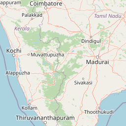
Map view of Vembanad Lake

Use this park location map to pinpoint Vembanad Lake in India, understand its exact geographic position, and read its mapped placement within the surrounding landscape more clearly.

Pigeon | © OpenStreetMap contributors

Examine mapped wetland habitats, shoreline vegetation, and regional terrain characteristics

Vembanad Photos and Protected Wetland Landscapes: Visual Guide to Scenery

Photographic collections reveal the intricate network of brackish lagoons, tidal estuaries, and below sea level agricultural mosaics shaping the protected wetland environment. Visual exploration highlights diverse waterbird habitats, mangrove fringes, and waterway geography defining the regional ecosystem.

A wide landscape shot of a calm lake reflecting a row of tall palm trees and a blue sky with white clouds. Patches of green aquatic vegetation float on the water surface.

Wide view of calm blue backwaters with houseboats and palm trees lining the banks under a clear sky

A wide landscape view of a calm lake featuring several long houseboats docked near the shore, with a dense background of coconut palm trees and aquatic plants in the foreground.

Park atlas

Compare adjacent wetland habitats, coastal lagoons, and connected regional reserves

Explore Protected Areas and Parks Near Vembanad in the Surrounding Region

Visitors exploring Vembanad can continue browsing nearby protected areas and regional wetland reserves for broader geographic comparison. Evaluating adjacent natural landscapes helps place Kerala's interconnected water systems within a wider conservation context.
National parkKerala
About 79 km away#1 closest

Northeast

Eravikulam National Park: National Park with Mapped Protected Boundaries in Kerala

Understanding its geographic setting and landscape identity.

Delve into the protected landscape of Eravikulam National Park, a significant national park located in Kerala. This detailed entry focuses on its geographic coordinates, mapped boundaries, and its role as a distinct protected area within the regional geography. It serves as a valuable resource for exploring the park's natural terrain and its importance in conservation landscapes.

Area
97 km²
Established
1978
IUCN
II
Visitors
148.4K annual
National parkIdukki
About 88 km away#2 closest

East

Mathikettan Shola National Park: National Park Exploration and Geographic Mapping

Discover its protected landscape and regional context.

Mathikettan Shola National Park, a designated national park in the Idukki region, offers a focal point for understanding protected landscapes and their geographic distribution. This entry details the park's mapped boundaries and its specific setting within the regional geography, providing an atlas-level view of its conservation value. Users can explore the structured geographic identity of this protected natural area, enriching their understanding of India's park network.

Area
12.82 km²
Established
2003
IUCN
II
Relief
Mountain
A minimalist, stylized vector art illustration of a mountain lake with a waterfall cascading down a cliff, surrounded by a coniferous forest under a soft sun.
Protected areaKerala
About 95 km away#3 closest

South

Sasthamkotta Lake Protected Area: Geography and Wetland Map Profile

Kerala's largest freshwater wetland and basin landscape

Investigate the territorial profile of Sasthamkotta Lake, an important Ramsar site in Kerala. This resource maps the lake's sheltered basin, shoreline hill contours, and connection to the alluvial plains of the Kallada River, highlighting its critical role in the regional hydrologic network.

Area
3.73 km²
Relief
Lowland
Climate
Tropical
Access
Easy access
National parkKerala
About 96 km away#4 closest

East

Periyar National Park: National Park Protected Area Atlas and Geographic Context

Mapped protected lands and regional landscape exploration in Kerala.

Discover Periyar National Park as a distinct protected landscape offering rich geographic context for atlas exploration. This entry details its mapped boundaries and its significance within the broader regional geography of Kerala. Understand the natural terrain and protected-area distribution that makes Periyar National Park a key element in India's conservation mapping.

Area
350.54 km²
Established
1982
IUCN
II
Visitors
754.3K annual
National parkKerala
About 96 km away#5 closest

Northeast

Anamudi Shola National Park: Protected Montane Forest and Wildlife Corridor in Kerala

Explore unique high-altitude ecosystems and regional landscape context.

Anamudi Shola National Park is a compact yet ecologically significant protected area situated in the Western Ghats of Kerala, India. Covering around 7.5 square kilometers, the park preserves rare montane shola forests at elevations exceeding 2,100 meters. Its identity as a critical wildlife corridor, connecting contiguous protected zones, is fundamental to its conservation value. The park's landscape, defined by its unique ecosystems and regional geographic position, offers valuable insights for atlas-driven exploration of protected natural areas.

Area
7.5 km²
Established
2003
IUCN
II
Relief
Mountain
Wildlife reserveIndia
About 100 km away#6 closest

Northeast

Anaimalai Tiger Reserve: Wildlife Reserve Park Atlas and Geographic Context in India

Mapping protected landscapes and natural terrain of this Indian wildlife reserve.

Anaimalai Tiger Reserve is a significant wildlife reserve located in India, offering rich opportunities for geographic and atlas-based discovery. This page provides detailed information on its protected area status, mapped boundaries, and the surrounding natural landscape context. Delve into the park's specific geography to understand its role as a conservation area within the broader Indian subcontinent.

A watercolor landscape painting of a calm lake with lush green vegetation on the banks and rolling hills in the background.
Wildlife reserveKerala
About 101 km away#7 closest

South

Ashtamudi Lake Wildlife Reserve: Geographic Atlas of Kerala Wetland Systems

Mapping the eight-armed estuary and coastal wetland landscape

Ashtamudi Lake is a major estuarine system in Kerala, defined by its branching topography and significant tidal influence. This atlas entry provides a clear perspective on the park's protected boundaries, including its mangrove patches, inland navigation channels, and island clusters that form the core of the regional wetland geography.

Area
61.4 km²
Established
2002
Visitors
25K annual
Relief
Lowland
National parkIndia
About 106 km away#8 closest

East

Pampadum Shola National Park: India's Protected Area Landscape Details

Explore mapped terrain and geographic context for this national park.

Gain insight into Pampadum Shola National Park, a key protected area within India's geography. This park detail provides essential information on its designation as a national park, its mapped boundaries, and its contribution to the regional landscape. It serves as a vital point for understanding the distribution and character of protected lands across India, offering a foundation for structured geographic research and atlas-based discovery of natural environments.

Common questions about visiting, size, designation, and location context for Vembanad Lake

Vembanad Lake FAQs for park facts, access, geography, and protected area context

Find quick answers about Vembanad Lake, including protected-area facts, park geography, trail and visitor context, and how the park fits into its surrounding country and regional landscape.
MoriAtlas Explorer

Continue Your Protected Areas Search Across the Global Atlas

Deepen your exploration by continuing the structured search for national parks and protected areas worldwide. Utilize the comprehensive filtering capabilities to compare different conservation landscapes and refine your understanding of global park geography. Discover more about the distribution and characteristics of protected natural areas.

Global natural geography