
Mori Atlas logo
Natural monumentVěřňovice

Mapping the river terrace ecology and protected woodland boundaries of this Czech natural site.

Věřňovice Natural Monument: A Protected Floodplain Forest Landscape in the Moravian-Silesian Region

Věřňovice Natural Monument is a four hectare protected site situated on a river terrace along the Olše river in the Moravian-Silesian Region. This area preserves a mosaic of elm-rich floodplain forest and oak-hornbeam woodland, representing a significant remnant of native habitat within the Karviná District. The terrain gently fluctuates between wet and dry pockets, providing an illustrative example of Central European riverine ecology for mapping and geographical study.

floodplain forestriparian woodlandriver terracesněženka podsněžníkdeciduous forestprotected natural monument
A flat-style digital illustration showing a winding river flowing through a forested valley toward a tall cliff face with waterfalls, under a soft pastel sky.

Věřňovice

Natural monument

Park overview

Structured park overview, official facts, and landscape profile for Věřňovice Natural Monument

Věřňovice Natural Monument park facts, protected area profile, and essential visitor context

Review the core facts for Věřňovice Natural Monument, including designation, size, terrain, visitor scale, habitats, and operating context in one park-focused overview.

About Věřňovice Natural Monument

Věřňovice Natural Monument is a compact but ecologically meaningful protected site in the northeastern corner of the Czech Republic. It sits on a clearly defined terrace of the Olše, a river that flows along the border between the Czech lands and Poland. This landscape setting, a flat raised bank above the floodplain, is exactly where natural floodplain forests once thrived, and Věřňovice preserves a representative fragment of that environment.

The reserve lies less than a kilometer from the small settlement of Věřňovice, which belongs administratively to the municipality of Dolní Lutyně in the Karviná District. Despite its location in a densely settled and historically industrialized part of the Moravian-Silesian Region, the protected area retains a notably natural forest character. The woodland is not commercial timber in feel, but a mosaic of native trees shaped by the soils and moisture conditions of the river terrace.

Visitors approaching the site encounter a landscape defined by its immediate relationship to the Olše. The terrace rises gently above the surrounding lowlands, and the forest within the reserve reflects the classic zonation of Central European floodplain woodlands. Wetter depressions support vegetation closer to elm floodplain forest, while the drier upper levels transition toward oak-hornbeam woodland, a pattern that gives the site much of its ecological interest.

Although the nature monument is small, only around four and a half hectares, it carries real conservation weight. It safeguards an example of how the original floodplain forests along the Olše functioned, it protects a notable snowdrop population, and it provides habitat for a recorded community of mammals and birds. As a 1989 designation, it also reflects the late-1980s wave of Czech small-site protections that aimed to anchor biodiversity outside the larger national parks.

Quick facts and research context for Věřňovice Natural Monument

Věřňovice was declared a natural monument on 15 May 1989 by the former District National Committee in Karviná. The site lies in the Moravian-Silesian Region, Karviná District, on the cadastral territory of Věřňovice, part of the municipality of Dolní Lutyně. It covers about 4.58 hectares at an elevation of roughly 201 to 216 meters above sea level.

The protected site centers on a prominent terrace of the Olše river and is dominated by floodplain forest, with patches of elm-rich woodland in wetter zones and oak-hornbeam forest on drier ground. Snowdrop colonies are a defining feature of the flora, while casual records document eighteen mammal species and forty bird species within the reserve.

Protection and recognition

Explore documented designation history and management scope for Věřňovice.

Věřňovice Protection Status and Terrestrial Conservation Data

Terrestrial protection records and conservation frameworks define the regulatory context surrounding Věřňovice. Structured recognition metrics and management parameters provide clear insight into its official status.

Protection details

Protection scope
Terrestrial
Transboundary protection
No
Park context

Deeper park guide and search-rich context for Věřňovice Natural Monument

Věřňovice Natural Monument history, landscape, wildlife, and travel context

Explore Věřňovice Natural Monument through its history, landscape character, ecosystems, wildlife, conservation priorities, cultural context, and seasonal travel timing in a structured park guide built for atlas discovery and search intent.

Why Věřňovice Natural Monument stands out

Věřňovice is best known for its well-preserved floodplain forest growing on the Olše river terrace and for its abundance of snowdrops (_Galanthus nivalis_), which form one of the most conspicuous features of the site in early spring. The reserve also illustrates the typical mosaic of wet and dry floodplain woodland found along the Olše, where elm-rich stands give way to oak-hornbeam forest over short distances. Beyond its botanical interest, the site reflects the broader natural heritage of the Czech-Polish border landscape in the Karviná District, where protected small patches help maintain native woodland communities and associated wildlife in a region otherwise strongly shaped by industry and settlement.
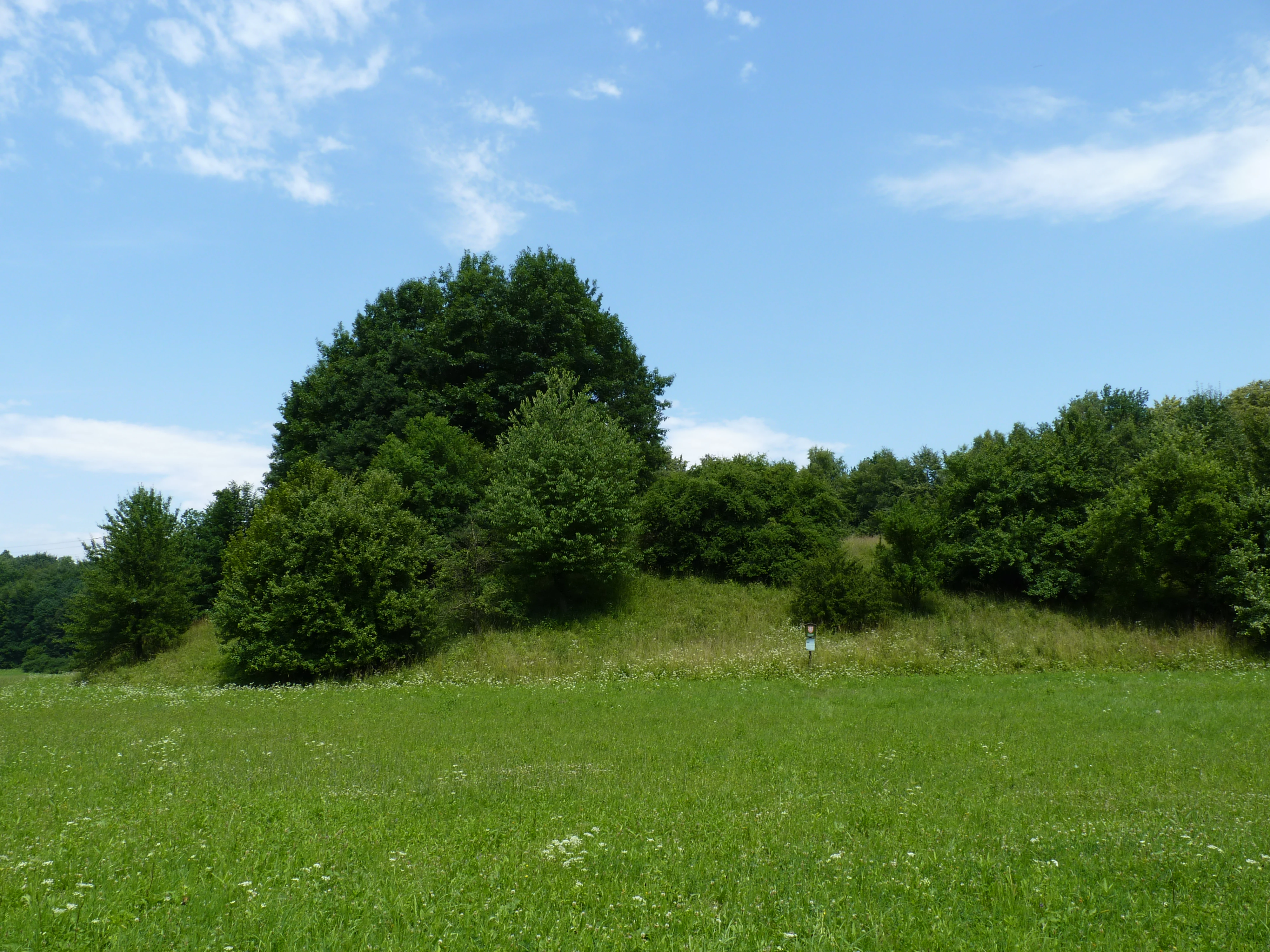
A wide view of a grassy meadow with scattered trees and a low rise of dense trees against a blue sky with light clouds.
A green meadow leading to a forested river terrace at the Věřňovice natural monument.

Věřňovice Natural Monument history and protected-area timeline

Věřňovice was officially declared a natural monument on 15 May 1989 by the District National Committee in Karviná. The designation came at a time when Czechoslovakia’s system of small protected areas was being significantly expanded to conserve locally important habitats, particularly in industrial and densely populated districts where larger reserves were impractical.

The site has since been administered by the Nature Conservation Agency of the Czech Republic, which manages the register of protected areas across the country. The natural monument registers under code 1227 in the national database, and the area remains a recognized component of the broader network of protected floodplain remnants along the Olše.

Aside from its formal establishment, the site’s history is essentially the history of the woodland itself, a long-maintained natural composition on a river terrace that escaped the more disruptive land uses that shaped much of the surrounding Karviná District landscape during the industrial twentieth century.

Věřňovice Natural Monument landscape and geographic character

The defining landscape feature of Věřňovice is a pronounced river terrace belonging to the Olše. The terrace sits a short distance from the active floodplain, elevated enough to form a distinct step in the terrain, and it carries the bulk of the protected area’s soils and woodland. Elevation across the site runs from roughly 201 to 216 meters above sea level, a small but ecologically meaningful range that helps drive the internal variation of the habitat.

Within the reserve, the land surface is gently undulating rather than dramatic. There are no cliffs, peaks, or large water bodies on the site itself; the visual interest comes instead from the texture of the woodland and the contrast between the slightly elevated terrace and the lower Olše floodplain beyond it. This quiet topography makes the natural monument feel like a careful window into the original riverine landscape, even though its surroundings have been substantially altered by human activity.

The terrain’s subtle but consistent patterns, wetter pockets alternating with better-drained ridges, are the foundation for the site’s habitat mosaic. These topographic differences translate directly into the floral communities described in the reserve’s natural history: elm-rich vegetation where the soils are heavier and more humid, and oak-hornbeam woodland where the surface dries out more readily.

Věřňovice Natural Monument ecosystems, habitats, and plant life

Věřňovice is, ecologically, a floodplain forest reserve, and the character of its vegetation reflects that single defining reality. The reserve is dominated by woodland rather than open meadow, with forest cover forming a continuous green canopy over the terrace. Within that canopy, however, two recognizable habitat types coexist side by side, reflecting moisture differences across the site.

In the wetter parts of the terrace, the forest carries the signature of elm floodplain woodland, a vegetation type historically common along lowland Central European rivers but now reduced to scattered fragments. In the drier portions, the trees shift toward a more upland composition resembling oak-hornbeam forest, a classic Central European community that thrives on better-drained but still base-rich soils. Together, these two woodland types give the small reserve an unusually rich habitat structure for its size.

The natural composition has been partially influenced by past plantings of non-native species, including northern red oak (_Quercus rubra_) and European beech (_Fagus sylvatica_), which interrupt the otherwise natural mix of native trees. Despite this, the site retains a strong natural character and an active ground flora, including a striking population of snowdrops (_Galanthus nivalis_), a species strongly associated with old, semi-natural deciduous woodland. The meadows in the southern part of the reserve are managed by regular mowing, an approach that keeps open habitats from being lost to shrub and tree encroachment and supports the broader habitat diversity of the site.

Věřňovice Natural Monument wildlife and species highlights

Wildlife records at Věřňovice document a meaningful diversity of animals for such a small reserve. Eighteen species of mammals have been recorded within the protected area, including the European badger (_Meles meles_) and the raccoon dog (_Nyctereutes procyonoides_), both species associated with mixed landscapes that combine woodland, edge habitats, and water.

The reserve also supports forty recorded bird species, a number that reflects the importance of vertical structure in the woodland and the proximity to the Olše river corridor. The combination of closed canopy, shrub layers, open meadows in the southern section, and adjacent aquatic and riparian habitats provides varied niches for forest, edge, and wetland-associated birds.

The wildlife profile of Věřňovice is therefore best understood as the result of a small but structurally rich woodland mosaic embedded within a broader working landscape. Even modest protected areas along the Olše can accumulate a respectable vertebrate list when their forest composition and management retain natural elements, and Věřňovice illustrates exactly that point.

Věřňovice Natural Monument conservation status and protection priorities

The conservation significance of Věřňovice rests on its role in preserving a representative fragment of floodplain forest along the Olše, a habitat type heavily reduced across Central Europe during the twentieth century. By protecting both the terrace’s natural woodland and its characteristic species, the reserve anchors a small but real piece of the river’s ecological heritage.

The site also has practical conservation value as a refuge for protected plant species, notably the snowdrop, and for a mammal and bird community that depends on intact native woodland structure. The presence of two distinct forest communities, elm-rich and oak-hornbeam, within a single small site makes the reserve disproportionately valuable for ecological representation: a site of just over four hectares can illustrate a habitat gradient that is now rare at landscape scale.

Management is carried out by the Nature Conservation Agency of the Czech Republic, which oversees the country’s small protected areas. Routine management includes mowing of the southern meadows, an action that maintains open ground against natural woodland succession. The site fits within the broader national framework for protecting small natural monuments, classified as IUCN Category III (natural monument or feature), and stands as a typical example of how targeted small-scale protection complements the country’s larger national parks and protected landscape areas.

Věřňovice Natural Monument cultural meaning and human context

Věřňovice’s cultural context is tied closely to the Karviná District and the border landscape of the Olše. The reserve lies near a small village of the same name, part of the municipality of Dolní Lutyně, and it sits in a region historically defined by the river as both a natural and a national boundary between the Czech lands and Poland. The broader Karviná area is widely known for its industrial past, particularly coal mining and heavy industry, which gives small natural sites like Věřňovice a special resonance as surviving green refuges within a heavily modified region.

The cultural layer is modest but real: the protected woodland is part of the local sense of place along the Olše, and its designation in 1989 reflects the late-twentieth-century shift toward recognizing small but ecologically valuable natural areas as part of regional identity and environmental heritage.

Top sights and standout views in Věřňovice Natural Monument

The standout qualities of Věřňovice lie in its combination of a clearly defined river terrace, a naturally composed floodplain forest, and an unusually rich display of snowdrops in early spring. The reserve’s mosaic of elm-rich and oak-hornbeam woodland within just a few hectares makes it a compact but illustrative example of Central European floodplain ecology.

Alongside these natural features, the reserve’s value as a small, formally protected green refuge in the Karviná District gives it additional significance. It demonstrates how even very small protected sites can preserve habitat structure, support recorded mammal and bird communities, and maintain rare woodland types that have largely vanished elsewhere along the Olše.

Best time to visit Věřňovice Natural Monument

The most rewarding time to experience Věřňovice is early spring, when the snowdrop population within the reserve comes into flower and the woodland floor brightens noticeably beneath the still-bare tree canopy. Visiting in spring also catches the contrast between wetter and drier parts of the terrace at its most visible, because the ground-level differences between elm-floodplain and oak-hornbeam woodland are easiest to read before the canopy fully closes.

Late spring and early summer are also appealing, particularly for observing the structure of the woodland and any meadow margins where mowing keeps the southern part of the reserve open. Autumn brings a quieter, more contemplative character, with forest colors and lower human activity along the Olše corridor. Winter visits are possible but offer little of the floral interest that defines the reserve’s identity.

Monthly climate preview

Long-term monthly temperature and precipitation averages recorded at Věřňovice

Věřňovice Climate Normals and Annual Temperature Rhythm

Historical climate records for Věřňovice outline a measurable annual cycle of shifting monthly temperatures and precipitation totals from representative coordinates. Comprehensive monthly normals provide deeper insight into long-term temperature ranges and precipitation patterns across the protected landscape.
Annual mean8 °C
-3 °C20 °C
Jan-3°
Feb-2°
Mar
Apr
May14°
Jun17°
Jul20°
Aug19°
Sep14°
Oct
Nov
Dec-2°
Warmest month
July

19.7 °C

Coolest month
January

-3.3 °C

Wettest month
July

3.1 mm/day

Driest month
January

1.2 mm/day

Park location guide

Geography guide, regional context, and park location map for Věřňovice Natural Monument

Věřňovice Natural Monument park geography, regions, and map view in Czechia

Understand where Věřňovice Natural Monument sits in Czechia through a broader geographic reading of the surrounding landscape, nearby location context, and its mapped position within the national park landscape.

How Věřňovice Natural Monument fits into Czechia

Czech Republic is a landlocked Central European country with a population of approximately 10.9 million people. The nation was established as an independent state on January 1, 1993, following the dissolution of Czechoslovakia. Its capital and largest city is Prague, with other major urban centers including Brno, Ostrava, Plzeň, and Liberec.

Wider geography shaping Věřňovice Natural Monument in Czechia

The Czech Republic is a landlocked country in Central Europe. It is bordered by Germany to the west, Austria to the south, Poland to the northeast, and Slovakia to the southeast. The landscape is predominantly hilly, with the territory covering 78,871 square kilometers.

Map view of Věřňovice Natural Monument

Use this park location map to pinpoint Věřňovice Natural Monument in Czechia, understand its exact geographic position, and read its mapped placement within the surrounding landscape more clearly.

Pigeon | © OpenStreetMap contributors

Location context for Věřňovice Natural Monument

Moravskoslezský kraj

Visualizing the river terrace, floodplain woodland, and natural habitats of Věřňovice.

Věřňovice Photos and Protected Landscape Scenery

Browse detailed photography capturing the distinctive river terrace and floodplain forest environments of Věřňovice. Visual documentation reveals the subtle terrain variations and native woodland mosaic that define this protected natural monument.

A wide view of a grassy meadow with scattered trees and a low rise of dense trees against a blue sky with light clouds.

Park atlas

Compare regional river terraces, floodplain forests, and nearby border landscapes

Explore Other Protected Areas and Natural Reserves Near Věřňovice

Continue investigating regional nature by browsing other protected areas surrounding Věřňovice and the Olše river valley. Examining adjacent woodland reserves and river terraces reveals broader ecological patterns across the Moravian-Silesian border landscape.
Watercolor painting of a meandering river landscape with green grasses, shrubs, and soft pink hills in the background.
Natural monumentMoravskoslezský kraj
About 18 km away#1 closest

South

Meandry Lučiny Natural Monument: Protected Riverine Geography and Floodplain Habitat Maps

Natural river meanders in the Moravian-Silesian landscape

This protected natural monument preserves a vital lowland river corridor where the Lučina River flows in an unregulated course. Through its shifting meanders and diverse floodplain habitats, the area highlights the ecological importance of maintaining natural hydrological processes in a heavily urbanized region of the Czech Republic.

Area
0.406 km²
Established
1992
IUCN
III
Relief
Lowland
Watercolor painting of a lush green landscape with trees, rolling hills, and a water feature in a soft pastel palette.
Protected landscapeSilesian Voivodeship
About 18 km away#2 closest

North

Park Krajobrazowy Cysterskie Kompozycje Krajobrazowe Rud Wielkich: A Silesian Protected Area

Riverine landscapes, forest corridors, and historic Cistercian pond networks

Situated in the Silesian Voivodeship, this protected landscape encompasses a significant portion of the Upper Oder basin. Its geography is characterized by a balance of managed forest, agricultural fields, and an intricate lattice of fishponds. These features provide critical refuge for waterbirds and preserve riparian woodland patterns that reflect centuries of deliberate landscape transformation by the Cistercian order.

Area
493.87 km²
Established
1993
Relief
Lowland
Climate
Temperate
Natural monumentMoravskoslezský kraj
About 19 km away#3 closest

South

Václavovice, pískovna Natural Monument: Mapped Geography and Protected Wetland Boundaries

Amphibian habitat and industrial site reclamation in Moravskoslezský kraj

Václavovice, pískovna represents a carefully managed natural monument where former quarrying activities have evolved into a rich mosaic of ponds, reeds, and damp woodland. Situated in the Moravian-Silesian Region, this compact site provides essential shelter for multiple amphibian species and underscores the importance of secondary natural habitats within broader regional geography.

Area
0.069 km²
Established
2013
IUCN
III
Relief
Lowland
A soft watercolor illustration depicting a green, open floodplain with rows of trees under a pale, gentle sky.
Nature reserveMoravskoslezský kraj
About 22 km away#4 closest

Southwest

Polanský les Nature Reserve: Mapped Protected Landscape and Floodplain Geography

A preserved hardwood forest relic in the Ostrava region

Polanský les maintains a critical status as a protected nature reserve, safeguarding a relic hardwood floodplain forest along the Oder River. This area is characterized by its significant botanical diversity, including established snowdrop populations and mature broadleaf woodland. Its location within the Moravskoslezský kraj highlights its role as a dense ecological fragment at the geological boundary between the Bohemian Massif and the Outer Western Carpathians.

Area
0.598 km²
Established
1970
IUCN
IV
Relief
Lowland
A horizontal watercolor painting depicting soft, layered green hills and purple-toned mountain ridges in the distance, with a foreground of stylized evergreen trees.
Protected landscapeSilesian Voivodeship
About 36 km away#5 closest

Southeast

Park Krajobrazowy Beskidu Śląskiego: Geographic Atlas of Protected Silesian Beskid Landscapes

Mapped mountain ridges, river headwaters, and protected forest reserves.

Gain insight into the ecological and structural character of Park Krajobrazowy Beskidu Śląskiego. This resource documents the park's flysch geological formations, rare cave systems, and the hydrological significance of the Vistula River headwaters within the Silesian Beskids.

Area
386.2 km²
Established
1998
Relief
Mountain
Climate
Alpine
Nature reserveSilesian Voivodeship
About 36 km away#6 closest

Southeast

Morzyk Nature Reserve: A Protected Forest Landscape in the Silesian Foothills of Southern Poland

Mapping forest communities and ravine terrain within the Silesian Voivodeship.

Morzyk Nature Reserve protects a rich mosaic of deciduous woodlands and beech-dominated stands in southern Poland. This compact forest reserve offers deep insight into the ecological character of the Silesian Foothills, featuring well-preserved ravines and old-growth trees that anchor the regional geography.

Area
0.103 km²
Established
1996
Relief
Upland
Climate
Temperate
Nature reservePoland
About 36 km away#7 closest

Southeast

Kościół w Górkach Wielkich: Nature Reserve and Protected Habitat in Silesian Voivodeship

Mapping cultural heritage and ecological sanctuary boundaries

Explore the geography of Kościół w Górkach Wielkich, a specialized Natura 2000 protected site situated within the Brenna commune. This entry provides context on the church architecture and the local protected terrain that creates a essential roost for regional bat populations in the Silesian Beskids foothills.

Relief
Lowland
Scope
Terrestrial
Water
Minor water
Natural monumentMoravskoslezský kraj
About 41 km away#8 closest

South

Vodopády Satiny Natural Monument: Mapped Geography and Protected Carpathian Landscapes

Regional geomorphology in the Moravskoslezský kraj

The Vodopády Satiny natural monument protects one of the most clearly exposed rock channels in the Czech Carpathians. Located in the Moravskoslezský kraj, the site demonstrates the impact of flysch geology on stream formation, where cascading waters have carved a distinct, long-exposure path through local mountain forests.

Area
0.09 km²
Established
2006
IUCN
III
Relief
Mountain

Common questions about visiting, size, designation, and location context for Věřňovice Natural Monument

Věřňovice Natural Monument FAQs for park facts, access, geography, and protected area context

Find quick answers about Věřňovice Natural Monument, including protected-area facts, park geography, trail and visitor context, and how the park fits into its surrounding country and regional landscape.
MoriAtlas Explorer

Continue Your Protected Areas Search Across the Global Atlas

Deepen your exploration by continuing the structured search for national parks and protected areas worldwide. Utilize the comprehensive filtering capabilities to compare different conservation landscapes and refine your understanding of global park geography. Discover more about the distribution and characteristics of protected natural areas.

Global natural geography