

Mori Atlas logo
Regional parkWaitawa Regional Park

Tracing the mapped boundaries and unique land use history of this Auckland regional park.

Waitawa Regional Park: Coastal Geography and Recreation Landscapes on the Tāmaki Strait

Waitawa Regional Park occupies a distinctive coastal setting along the western shore of the Firth of Thames, defined by its position on the Tāmaki Strait within the Auckland Region. Unlike traditional protected landscapes, this area reflects a complex transition from a former dynamite factory and agricultural site into a purpose-built space for active recreation. The open grassy terrain and beach-front accessibility provide a clear view of how public land use can transform coastal geography.

regional parkcoastal parkactive recreationmountain bikinghorse ridingkayaking

Waitawa Regional Park

Regional park

Park overview

Structured park overview, official facts, and landscape profile for Waitawa Regional Park

Waitawa Regional Park park facts, protected area profile, and essential visitor context

Review the core facts for Waitawa Regional Park, including designation, size, terrain, visitor scale, habitats, and operating context in one park-focused overview.

About Waitawa Regional Park

Waitawa Regional Park sits on the western edge of the Firth of Thames coastline on the Tāmaki Strait, southeast of Auckland's urban area, and forms part of the Auckland Council regional parks network. Its position near Kawakawa Bay and Clevedon places it within a transition zone between the rural landscapes of the Franklin district and the rapidly urbanizing Auckland Region, giving the park an important role as accessible open space for both nearby coastal communities and visitors from central Auckland.

The park covers roughly 188 hectares of coastal and near-coastal terrain. Its setting combines open grassy areas, planted and regenerating vegetation, and direct frontage onto tidal waters of the Tāmaki Strait. These coastal views and beach access points define much of Waitawa's everyday visitor experience and also underpin its strong emphasis on water-based recreation, particularly kayaking along and beyond the park's shoreline.

Waitawa is notable within the Auckland regional parks system for the way it was conceived and developed. Rather than evolving gradually from older forest or scenic reserves, it was deliberately established as a recreation-oriented park in 2013, with tracks, trails, and activity areas designed in from the outset to support mountain biking, horse riding, kayaking, and disc golf. Its formal integration with regional networks such as the Te Ara Moana Kayak Trail and plans for marine education at one of its beaches show how the park has been planned as a node within wider coastal recreation and learning routes.

Beyond its recreational role, Waitawa also carries a tangible layer of industrial and rural history. The land it occupies was previously used as a dynamite factory by Orica Explosives and, before that, as farmland. A surviving commercial wharf and ablutions building from the factory era remain on site as reminders of the area's working past. This combination of industrial heritage, coastal scenery, and modern recreation infrastructure gives the park a layered identity that distinguishes it from more conventionally scenic regional parks in the Auckland network.

Quick facts and research context for Waitawa Regional Park

Waitawa Regional Park is located in the Franklin local board area of the Auckland Region, on the coast of the Tāmaki Strait east of Auckland city. The park covers approximately 188 hectares (around 460 acres) and was established in 2013, with Auckland Council taking over its management in 2014 following the reorganization of Auckland's local government.

It is one of the first regional parks in the Auckland network to be designed primarily around active recreation, with formal provision for mountain biking, horse riding, kayaking, and disc golf. A section of the Te Ara Moana Kayak Trail runs along one of the park's beaches, and another beach area has been earmarked as a base for marine education activities.

Protection and recognition

Examine terrestrial protected area designations and management scope.

Waitawa Regional Park Protection Status and International Recognition

Waitawa Regional Park maintains documented terrestrial protection status within its regional landscape. Structured records outline the governing management framework and international recognition details.

Protection details

Protection scope
Terrestrial
Transboundary protection
No
Park context

Deeper park guide and search-rich context for Waitawa Regional Park

Waitawa Regional Park history, landscape, wildlife, and travel context

Explore Waitawa Regional Park through its history, landscape character, ecosystems, wildlife, conservation priorities, cultural context, and seasonal travel timing in a structured park guide built for atlas discovery and search intent.

Why Waitawa Regional Park stands out

Waitawa Regional Park is best known as one of Auckland's first regional parks purpose-built for active outdoor recreation. Its defining identity lies in the combination of a coastal Tāmaki Strait location with developed facilities for mountain biking, horse riding, kayaking, and disc golf, rather than the more passive nature-based experiences typical of older regional parks. The park also stands out for its unusual origin. It was converted from a former Orica Explosives dynamite factory site, with farmland worked in earlier decades, into a publicly accessible coastal park. This transition from heavy industrial and agricultural land to a recreation-focused public space gives Waitawa a distinctive story compared with other parks in the regional network.
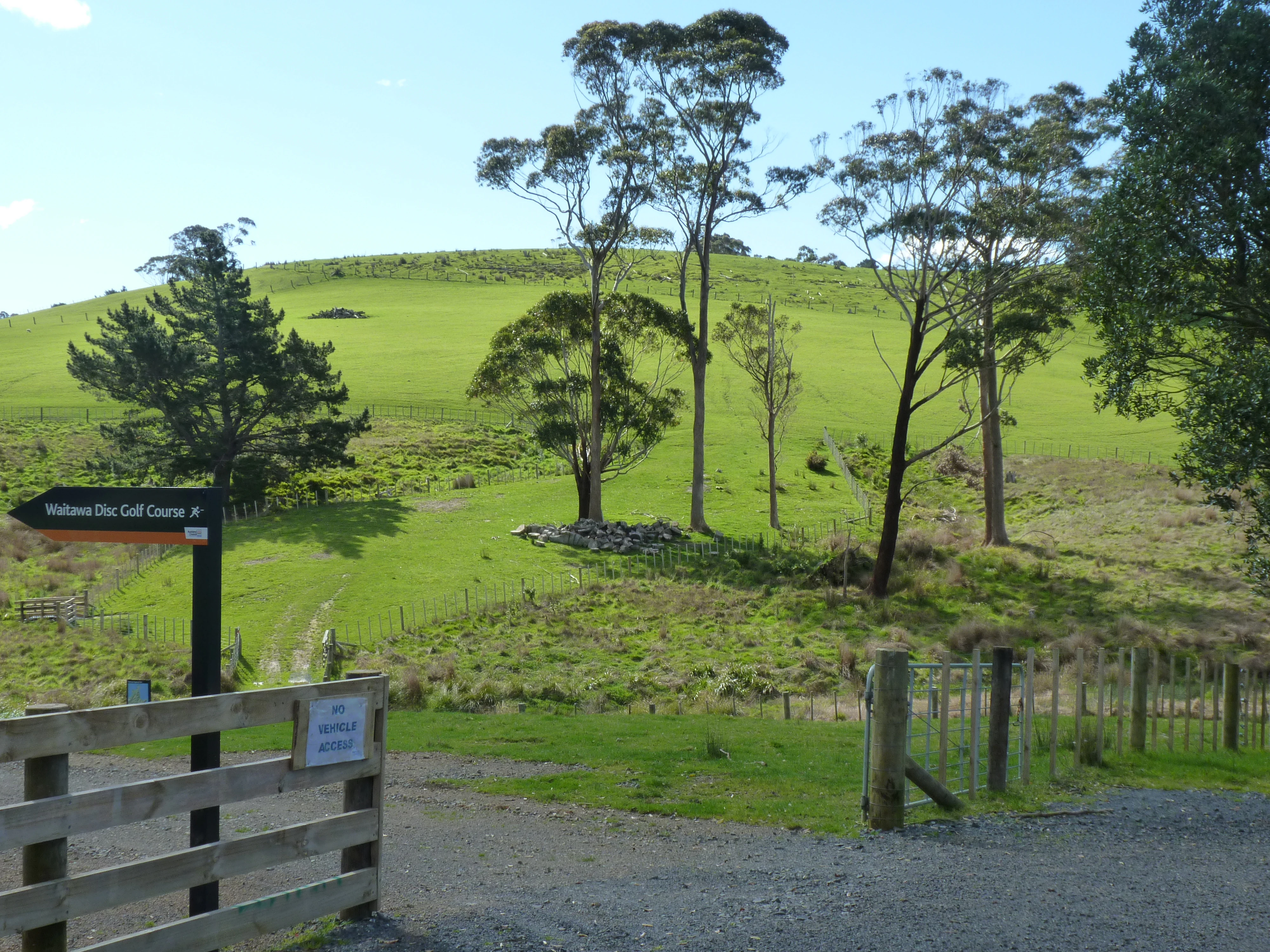
Waitawa Regional Park landscape
View of the coastline and terrain at Waitawa Regional Park in New Zealand

Waitawa Regional Park history and protected-area timeline

The land that now forms Waitawa Regional Park was once part of the rural hinterland east of Auckland and was worked as farmland before undergoing a more industrial phase. During the twentieth century the site was used by Orica Explosives as a dynamite factory, a use shaped by the coastal location and the presence of a working wharf that could accommodate shipping. A commercial wharf and an ablutions building from this era are still present within the park.

Following the end of its industrial use, the site was purchased in 2004 by the former Auckland Regional Council as part of a broader move to expand publicly accessible open space in the Auckland region. The land was then progressively developed into a regional park, with Waitawa Regional Park formally created in 2013.

Management of the park transitioned to Auckland Council in 2014, when the new unitary authority took over responsibility for regional parks following Auckland's local government amalgamation. Under Auckland Council, the park has continued to be developed around its central role as an active recreation destination, integrated with regional networks such as the Te Ara Moana Kayak Trail.

Waitawa Regional Park landscape and geographic character

Waitawa Regional Park occupies a coastal and near-coastal landscape on the shore of the Tāmaki Strait, the broad tidal inlet that marks the western margin of the Firth of Thames. The terrain is predominantly low-lying and open, shaped by its position along the edge of the sea, with grassy areas, coastal margins, and stretches that were historically cleared for farming or industrial use.

The park's beach frontage is one of its defining physical features. Beaches along the Tāmaki Strait shoreline provide both recreational access to the water and scenic outlooks across the strait toward the Coromandel Peninsula side of the firth. An older commercial wharf, surviving from the dynamite factory era, extends into this coastal zone and remains a recognizable feature of the park's shoreline.

Inland from the beaches, the landscape is characterized by relatively open country rather than dense native forest, reflecting both the agricultural and industrial history of the site and the deliberate planning of the park for active recreation. Trails, open riding areas, and coastal vantage points are nested into this gently rolling coastal land, giving the park an accessible, open-air character distinct from busier forested regional parks in the Auckland network.

Waitawa Regional Park ecosystems, habitats, and plant life

The ecological character of Waitawa Regional Park reflects its coastal position on the Tāmaki Strait and its history of clearance for agriculture and industry. Much of the park's land has been shaped by past human use, and the vegetation that visitors encounter today is a mix of open grassy areas, regenerating coastal vegetation, and planted landscape elements rather than mature native forest.

The park's coastal edge supports habitat typical of sheltered Tāmaki Strait shores, including intertidal zones along its beaches and margins. These areas provide foraging conditions for seabirds and shorebirds associated with the firth, and the calm waters of the strait offer conditions favorable for paddling-based recreation and observation. Plans to develop one of the park's beaches as a marine education base reflect growing recognition of these coastal and marine values.

Because the park was designed primarily for active recreation rather than as a nature reserve in the traditional sense, its nature experience is closely tied to the coastal scenery, tidal waters, and open-air landscape of the Tāmaki Strait shore, rather than to intact native habitat blocks. This gives Waitawa a coastal-recreation ecological identity that complements, rather than duplicates, the more forest- or mountain-oriented parks elsewhere in the Auckland regional system.

Waitawa Regional Park wildlife and species highlights

Waitawa Regional Park is situated on the Tāmaki Strait, an inlet known for its sheltered waters and its importance for coastal and estuarine birdlife. Its beaches and tidal margins provide habitat for shore species associated with the Firth of Thames coastline, and the open coastal and grassy environments of the park are used by a range of common New Zealand coastal birds.

The park's role as a coastal recreation and education site also brings visitors into regular contact with marine life in the adjacent waters. Plans to use one of the park's beaches as a base for marine education suggest an increasing focus on connecting visitors with the marine species and ecosystems of the Tāmaki Strait, even though the park itself is primarily built around active land-based recreation.

Because the park's land has been historically cleared and used for farming and industry, large native fauna are not the main draw. The wildlife experience here is shaped more by coastal and shoreline species, marine life in the adjacent strait, and the general open-country birdlife typical of New Zealand's coastal pastures and regenerating coastal vegetation.

Waitawa Regional Park conservation status and protection priorities

As a regional park within the Auckland Council network, Waitawa contributes to the broader goal of preserving publicly accessible green and coastal space in a region experiencing rapid urban growth. Its conversion from a former industrial and agricultural site into permanently protected public land represents a significant long-term conservation and land-use outcome, locking the site into open-space use rather than further development.

The park also plays a part in protecting and managing coastal margin habitat along the Tāmaki Strait. Although much of the terrestrial vegetation has been shaped by past land uses, the shoreline itself, including the intertidal areas along the park's beaches, is part of the ecologically important Firth of Thames coastal environment. By retaining this land in public ownership and incorporating marine education functions, the park contributes to awareness and stewardship of the wider coastal ecosystem.

Within the Auckland regional parks network, Waitawa exemplifies an approach to conservation that pairs ecosystem and coastal preservation with high-quality recreation access. Its creation in 2013 and transfer to Auckland Council management in 2014 marked a consolidation of this dual role, ensuring that the site's ecological, scenic, and recreational values are managed together under a single public authority.

Waitawa Regional Park cultural meaning and human context

The land on which Waitawa Regional Park sits carries a layered human history. Before its modern recreational role, the area was part of the rural working landscape east of Auckland, used as farmland before taking on a more heavy-industrial role as the site of a dynamite factory operated by Orica Explosives.

The dynamite factory period left a distinctive mark on the park. The presence of a coastal commercial wharf and surviving ablutions building from that era ties the site to New Zealand's twentieth-century industrial and infrastructural history, particularly around the storage, manufacture, and shipping of explosives along sheltered tidal waters.

More broadly, the park's location near Kawakawa Bay and Clevedon places it within coastal Franklin communities with their own strong identities tied to the sea, rural hinterland, and the broader Auckland region. Waitawa's emergence as a regional park in 2013 reinforced this regional sense of place, providing a new focal point for outdoor activity in an area long associated with farming, small-scale industry, and the tidal waters of the Tāmaki Strait.

Top sights and standout views in Waitawa Regional Park

One of Auckland's first regional parks designed from the outset around active recreation, with dedicated trail networks and facilities for mountain biking, horse riding, kayaking, and disc golf. Direct coastal frontage on the Tāmaki Strait, with beaches that link into regional networks such as the Te Ara Moana Kayak Trail. A distinctive land-use story built on the conversion of a former Orica Explosives dynamite factory and surrounding farmland into a publicly owned regional park in 2013. Open grassy terrain combined with coastal scenery and surviving industrial-era structures such as the old commercial wharf and ablutions building, giving the park a unique character within the Auckland regional parks system.

Best time to visit Waitawa Regional Park

As a coastal park on the Tāmaki Strait, Waitawa's appeal shifts with the seasons in ways typical of Auckland's eastern coastlines. Warmer months tend to bring the best conditions for beach-based activity, kayaking on the sheltered strait, and active outdoor recreation such as mountain biking and horse riding, while cooler and wetter periods produce greener landscapes and a quieter, more contemplative atmosphere along the coastal tracks. Daylight hours also influence the experience, since the park's vehicle-access hours vary between daylight saving and non-daylight saving periods, with pedestrian access available around the clock.

Monthly climate preview

Long-term representative point measurements tracking monthly temperature and precipitation cycles

Waitawa Regional Park Climate Normals, Annual Temperature and Precipitation Rhythm

Historical NASA Power climatology records outline the measured monthly temperature range and precipitation averages at a representative coordinate within Waitawa Regional Park. Reviewing twelve-month averages provides precise long-term baseline data for studying regional environmental patterns across the terrain.
Annual mean16 °C
11 °C20 °C
Jan20°
Feb20°
Mar19°
Apr17°
May15°
Jun12°
Jul11°
Aug12°
Sep13°
Oct14°
Nov16°
Dec18°
Warmest month
February

20.3 °C

Coolest month
July

11.4 °C

Wettest month
July

3.7 mm/day

Driest month
January

1.8 mm/day

Park location guide

Geography guide, regional context, and park location map for Waitawa Regional Park

Waitawa Regional Park park geography, regions, and map view in New Zealand

Understand where Waitawa Regional Park sits in New Zealand through a broader geographic reading of the surrounding landscape, nearby location context, and its mapped position within the national park landscape.

How Waitawa Regional Park fits into New Zealand

New Zealand is an island nation in the southwestern Pacific Ocean comprising two main islands and numerous smaller islands. Located east of Australia across the Tasman Sea, it features varied topography with the Southern Alps running along the South Island and volcanic terrain on the North Island. The country was settled by Maori people between 1280 and 1350, followed by European exploration beginning in 1642, and became a Dominion in 1907 before gaining full independence in 1947.

Wider geography shaping Waitawa Regional Park in New Zealand

New Zealand lies in the southwestern Pacific Ocean, east of Australia across the Tasman Sea. The country consists of two main islands, the North Island and South Island, plus over 600 smaller islands. The North Island features volcanic plateaus and hills while the South Island is dominated by the Southern Alps mountain range. The country has a long coastline and is surrounded by the Pacific Ocean.

Map view of Waitawa Regional Park

Use this park location map to pinpoint Waitawa Regional Park in New Zealand, understand its exact geographic position, and read its mapped placement within the surrounding landscape more clearly.

Pigeon | © OpenStreetMap contributors

Location context for Waitawa Regional Park

Auckland Region
Recorded earthquake history

Review Recorded Earthquake History Associated With Waitawa Regional Park

Explore historical seismic data documented near Waitawa Regional Park. This collection presents a factual record of nearby events, allowing for a clearer understanding of regional seismic activity through structured, data-driven entries for every tracked epicentre.

Waitawa Regional Park Earthquake History

Catalogued events

3 events

Strongest magnitude

Magnitude 4.5

Most recent event

Mar 13, 2007

This history includes earthquakes recorded inside the park or within 50 km of its borders

Visualizing open terrain, coastal margins, and protected park environments

Waitawa Regional Park Photos and Coastal Landscape Scenery

Browse detailed imagery documenting the open grassy terrain and coastal vistas of Waitawa Regional Park along the Tāmaki Strait. Visual documentation reveals the unique combination of active recreation trails and industrial heritage that defines the protected landscape.

Waitawa Regional Park landscape

Park atlas

Compare coastal terrain and regional protected areas across the Auckland coastline.

Explore Parks Near Waitawa Regional Park and Surrounding Protected Landscapes

Browsing other parks near Waitawa Regional Park reveals the diverse geography of the Tāmaki Strait coastline and nearby regional reserves. Analyzing adjacent protected landscapes provides valuable context for comparing coastal recreation and open terrain across the wider region.
Regional parkAuckland Region
12 km away#1 closest

Northwest

Whakanewha Regional Park: Mapping the Protected Landscapes and Wetlands of Waiheke Island

Coastal forest and wetland geography in the Auckland Region

Whakanewha Regional Park serves as a vital protected area on Waiheke Island, known for its mature broadleaf forests and significant freshwater wetlands. The park provides a compact yet varied landscape of stream valleys and coastal ridgelines, representing a key component of the regional geography within the Hauraki Gulf, sheltered from broader environmental pressures.

Area
2.7 km²
Established
2007
Relief
Upland
Climate
Temperate
Nature reserveAuckland Region
About 13 km away#2 closest

North

Rotoroa Island Nature Reserve: Mapping the Geography of this Hauraki Gulf Sanctuary

A vital protected island terrain for native species and reforestation

Rotoroa Island serves as a managed conservation landscape within the Hauraki Gulf, defined by its role as a pest-free sanctuary for threatened bird populations and intensive native forest restoration. The island offers a distinct geography that combines maritime coastal terrain with a rich history of social welfare, preserved through intentional land management and active environmental rehabilitation efforts near the Auckland coast.

Area
0.82 km²
Established
2011
Relief
Lowland
Scope
Terrestrial
Regional parkWaikato Region
15 km away#3 closest

Southeast

Waharau Regional Park: Protected Coastal Forest and Hunua Ranges Gateway

Geographic landscape transition in the Waikato region

This protected area offers a deep look into the transition from native forest hill country to estuarine environments along the Firth of Thames. Spanning 170 hectares, it serves as a functional geographic corridor between the Hunua Ranges and the Hauraki Gulf, showcasing layered history and varied topography within the Waikato region.

Area
1.7 km²
Established
1979
Relief
Upland
Climate
Temperate
Wildlife reserveAuckland
About 22 km away#4 closest

Northwest

Motuihe Island Wildlife Reserve: Protected Landscapes and Hauraki Gulf Geography

Ecological restoration and coastal island history near Auckland

Motuihe Island represents a significant case study in island conservation, featuring intensive native forest regeneration and successful wildlife reintroduction. The mapped landscape details an elongated island geography defined by coastal beaches, sandstone terrain, and rich archaeological layers, serving as a prominent protected reserve for the Auckland region.

Area
1.79 km²
Relief
Lowland
Climate
Subtropical
Access
Moderate access
Nature reserveAuckland
About 27 km away#5 closest

West

Puhinui Reserve: Protected Nature Reserve and Volcanic Geography in Auckland, New Zealand

Coastal wetlands, maar craters, and working agricultural lands

Explore the physical geography of Puhinui Reserve, a protected nature reserve in South Auckland. This site encompasses rare saltmarsh habitat, active volcanic maar features, and estuarine environments situated on the shores of the Manukau Harbour. Gain insight into the volcanic ash, alluvium, and peat soil structures that define this unique transitional landscape.

Area
1.99 km²
Established
1991
Relief
Lowland
Climate
Temperate
Protected areaAuckland Region
About 42 km away#6 closest

West

Motumānawa / Pollen Island: Protected Marine Reserve and Scientific Landscape in Auckland

A coastal shellbank island refuge within the Waitematā Harbour.

Motumānawa / Pollen Island is an essential protected area near the Rosebank Peninsula, serving as a sanctuary for native bird populations and estuarine vegetation. Its status as both a scientific and marine reserve highlights the importance of small-scale coastal conservation within a major metropolitan harbour landscape in New Zealand.

Established
2006
Relief
Lowland
Scope
Marine
Water
Water-dominated
Protected areaWaikato Region
About 47 km away#7 closest

East

Coromandel Forest Park: Geography and Protected Area Overview in Waikato, NZ

Native bushland, valley systems, and conservation geography.

Coromandel Forest Park comprises an expansive system of forested hills and valleys covering the heart of the Coromandel Peninsula. This protected area features dense native ecosystems, ranging from the accessible Kauaeranga Valley to the ecologically significant southern blocks. Use this atlas perspective to understand the terrain, boundaries, and conservation value of this essential Waikato Region landscape.

Area
718.99 km²
Established
1971
Relief
Upland
Climate
Temperate
Regional parkAuckland Region
About 55 km away#8 closest

West

Waitākere Ranges Regional Park: Geographic Mapping of Auckland's Protected Coastal Forest

Volcanic terrain and expansive coastal wilderness boundaries

Examine the rugged geography of the Waitākere Ranges, spanning from sheer western sea cliffs to lush, regenerating forest valleys. This overview details the protected land, including volcanic rock formations, black sand surf beaches, and the inland reservoirs serving the Auckland region, highlighting its status as an ecologically critical heritage area.

Area
277.2 km²
Established
1895
Relief
Mountain
Climate
Subtropical

Common questions about visiting, size, designation, and location context for Waitawa Regional Park

Waitawa Regional Park FAQs for park facts, access, geography, and protected area context

Find quick answers about Waitawa Regional Park, including protected-area facts, park geography, trail and visitor context, and how the park fits into its surrounding country and regional landscape.
MoriAtlas Explorer

Continue Your Protected Areas Search Across the Global Atlas

Deepen your exploration by continuing the structured search for national parks and protected areas worldwide. Utilize the comprehensive filtering capabilities to compare different conservation landscapes and refine your understanding of global park geography. Discover more about the distribution and characteristics of protected natural areas.

Global natural geography