

Mori Atlas logo
National parkWalpole-Nornalup National Park

Explore the mapped boundaries and regional geography of this significant Western Australian protected area.

Walpole-Nornalup National Park: Protected Landscape Identity and Geographic Atlas Context

Walpole-Nornalup National Park stands as a key protected area within the diverse landscapes of Western Australia. This page offers an atlas-driven exploration of its distinct geographic identity, focusing on the park's mapped boundaries and its role within the broader regional context. Understand the natural terrain and landscape features that define this significant national park.

Ancient forestKarri forestTingle treesValley of the GiantsSouth West AustraliaTree Top Walk

Walpole-Nornalup National Park

National park

Park overview

Structured park overview, official facts, and landscape profile for Walpole-Nornalup National Park

Walpole-Nornalup National Park park facts, protected area profile, and essential visitor context
Review the core facts for Walpole-Nornalup National Park, including designation, size, terrain, visitor scale, habitats, and operating context in one park-focused overview.

About Walpole-Nornalup National Park

Walpole-Nornalup National Park represents one of Western Australia's most significant protected forest areas, encompassing a diverse range of habitats from towering inland karri and tingle forests to coastal heathland and the Walpole-Nornalup Inlets system. The park's establishment as a conservation area dates back to 1910 when the Minister of Lands and Agriculture, James Mitchell, was so impressed by the region's beauty during a visit that he set aside 370 hectares as an A-class reserve. Additional areas were added in 1912, and the park was formally declared in 1957. In 2004, the park became part of the broader Walpole Wilderness Area, recognizing its significance within an international biodiversity hotspot. The Valley of the Giants remains the park's signature attraction, offering visitors the opportunity to walk among giants through the Tree Top Walk structure and explore the Ancient Empire walkway beneath the canopy. The park provides habitat for diverse flora and fauna adapted to the fire-prone southern forests, with species having evolved remarkable strategies for surviving periodic bushfires that characterize the region.

Quick facts and research context for Walpole-Nornalup National Park

Located in Western Australia's South West region, Walpole-Nornalup National Park covers 194.48 square kilometres and was first reserved in 1910 before being formally declared a national park in 1957. The park is managed by the Department of Environment and Conservation and features the iconic Tree Top Walk, a 40-metre-high walkway through the canopy of the Valley of the Giants. The Bibbulmun Track traverses the park, connecting inland forest to the coast. Conspicuous Cliff provides one of the few coastal access points within the park and serves as a whale watching vantage point during migration seasons. The park received approximately 158,000 visitors annually as of 2008-2009.

Park context

Deeper park guide and search-rich context for Walpole-Nornalup National Park

Walpole-Nornalup National Park history, landscape, wildlife, and travel context
Explore Walpole-Nornalup National Park through its history, landscape character, ecosystems, wildlife, conservation priorities, cultural context, and seasonal travel timing in a structured park guide built for atlas discovery and search intent.

Why Walpole-Nornalup National Park stands out

Walpole-Nornalup is renowned for its extraordinary ancient forests dominated by red tingle trees that are found nowhere else on Earth. The Valley of the Giants contains some of the largest and oldest tingle trees in the world, with the Tree Top Walk providing visitors with a unique elevated perspective through the forest canopy 40 metres above ground. The park's karri forests add to its botanical significance, with both species reaching impressive heights. The combination of inland old-growth forest, coastal heathland, river inlets, and accessibility through structures like the Tree Top Walk makes this park a flagship destination for experiencing Western Australia's southern forest ecosystems.

Walpole-Nornalup National Park history and protected-area timeline

The traditional owners of Walpole-Nornalup National Park are the Murrum of the Minang peoples within the larger Noongar group, who have inhabited the region for over 30,000 years. The Noongar peoples know the area as Nor-Nor-Nup, meaning 'the place of the black snake,' a name that was later anglicized to Nornalup. European discovery began with explorer William Nairne Clark in 1841, who sailed up the Frankland River, followed by botanist Ferdinand von Mueller in 1877. The Bellanger family became the first European settlers in 1910, establishing a homestead along the Frankland River in 1914. The park is named after the nearby town of Walpole, which in turn honors William Walpole, who served alongside James Stirling on HMS Warspite in 1809. The conservation significance of the area was recognized early, with the first reservation in 1910 inspired by the region's exceptional natural beauty. The park has since grown to encompass its present 194.48 square kilometres and became integrated into the Walpole Wilderness Area in 2004.

Walpole-Nornalup National Park landscape and geographic character

Walpole-Nornalup National Park features a dramatic transition from dense inland forest to coastal environments. The park's interior is characterized by towering karri and red tingle trees, with the Valley of the Giants containing some of the most impressive specimens. The red tingle is endemic to the Walpole area and represents a distinctive element of the landscape found nowhere else in the world. The forest floor supports a diverse understory adapted to the periodic fire regime of the region. Near the coast, the landscape shifts to coastal heathland featuring swamp paperbark and endemic red flowering gums. The Walpole-Nornalup Inlets, fed by the Deep and Frankland rivers, create estuarine environments where freshwater meets the Southern Ocean. Conspicuous Cliff provides one of the few accessible coastal points within the park, offering dramatic ocean views and exposure to the Southern Ocean's limestone cliffs. The Bibbulmun Track winds through the park's varied terrain, connecting these distinct landscape types.

Walpole-Nornalup National Park ecosystems, habitats, and plant life

The ecological character of Walpole-Nornalup National Park is defined by its southern Australian forest ecosystems, which form part of the Southwest Australia Floristic Region recognized as a global biodiversity hotspot. The park protects old-growth forests dominated by karri (Eucalyptus diversicolor) and red tingle (Eucalyptus jacksonii), with the latter species being endemic to the Walpole region. The forest understory contains diverse heath species, sedges, and ferns adapted to the nutrient-poor soils and Mediterranean climate of the region. The tingle trees have evolved remarkable adaptations to fire, capable of surviving low-level burns and regenerating from beneath their bark even when appearing severely damaged. The park's coastal habitats include heathland with swamp paperbark and endemic red flowering gums, while the inlets support wetland and estuarine communities. The integration of forest, heath, and aquatic environments creates a mosaic of habitats that supports considerable biodiversity within a relatively compact protected area.

Walpole-Nornalup National Park wildlife and species highlights

The forests and coastal environments of Walpole-Nornalup provide habitat for diverse wildlife adapted to the southern Australian landscape. Birdlife includes various parrot species, honeyeaters, and birds of prey that utilize the forest canopy and edges. The coastal areas and inlets support marine mammals including dolphins, with the nearby waters serving as migration routes for humpback and southern right whales. The forest floor and understory provide habitat for various marsupials, reptiles, and invertebrates adapted to the fire-prone ecosystem. The old-growth trees themselves support hollow-dependent species including birds and mammals that require mature trees for nesting and shelter. The Bibbulmun Track passes through the park, offering opportunities to observe wildlife in relatively intact natural habitats.

Walpole-Nornalup National Park conservation status and protection priorities

Walpole-Nornalup National Park represents significant conservation value within Australia's protected area network, particularly as part of the Walpole Wilderness Area established in 2004 within a global biodiversity hotspot. The park protects endemic species including the red tingle, which occurs naturally only in the Walpole area. The old-growth forest communities represent some of the last remaining examples of these ecosystems in the region. The Department of Parks and Wildlife manages the park through controlled burning programs for fuel reduction, aimed at reducing the risk of catastrophic bushfire while allowing natural fire-adapted species to persist. The integration of forest, coastal, and wetland habitats within a single protected area preserves ecological connections that might otherwise be lost in fragmented landscapes. The Tree Top Walk and other visitor infrastructure also serve an educational function, connecting people with the forest environment and supporting conservation awareness.

Walpole-Nornalup National Park cultural meaning and human context

Walpole-Nornalup holds deep significance for the Noongar peoples, whose traditional territory spans the South West region of Western Australia. The area is known to the Murrum of the Minang peoples as Nor-Nor-Nup, meaning 'the place of the black snake,' reflecting the long human presence in this landscape over at least 30,000 years. The naming of the park after Walpole connects to colonial history, with the town named after William Walpole who served aboard HMS Warspite. The Bellanger family represented early European settlement, establishing the first European homestead in the area in 1914. The park thus represents a meeting point of Aboriginal heritage spanning millennia and more recent European exploration and settlement history, all within a landscape that retains much of its natural character.

Top sights and standout views in Walpole-Nornalup National Park

The Valley of the Giants stands as the park's signature attraction, featuring the Tree Top Walk, a 40-metre-high steel walkway that allows visitors to experience the forest canopy up close. The Ancient Empire walkway at ground level provides complementary access to the base of the giant tingle trees. Conspicuous Cliff offers one of the park's few coastal access points and serves as an excellent whale watching location during migration seasons when humpback and southern right whales pass the coastline. The Bibbulmun Track traverses the park, providing hikers with a multi-day opportunity to experience the transition from inland forest to coast. The park's unique red tingle trees, found nowhere else on Earth, represent a living heritage of ancient forest ecosystems.

Best time to visit Walpole-Nornalup National Park

The park can be visited throughout the year, though autumn and spring typically offer comfortable conditions for outdoor activities. The summer months (December to February) bring warmer temperatures suitable for the beach and coastal sections, while winter (June to August) provides a different character with increased rainfall and damper forest conditions. The whale watching season at Conspicuous Beach peaks during the winter and spring migration periods. The Tree Top Walk remains accessible year-round, though some visitors prefer the clearer visibility and comfortable temperatures of the shoulder seasons. Fire risk typically increases during the hot summer months, which may affect some trail access.
Park location guide

Geography guide, regional context, and park location map for Walpole-Nornalup National Park

Walpole-Nornalup National Park park geography, regions, and map view in Australia
Understand where Walpole-Nornalup National Park sits in Australia through a broader geographic reading of the surrounding landscape, nearby location context, and its mapped position within the national park landscape.

How Walpole-Nornalup National Park fits into Australia

Australia is a constitutional monarchy and federal parliamentary democracy comprising six states and ten territories. With a population of nearly 28 million, it is one of the world's most urbanised countries, with most people concentrated on the eastern seaboard. The country has a high Human Development Index and is known for its cultural diversity, ancient Aboriginal heritage, and unique wildlife.

Wider geography shaping Walpole-Nornalup National Park in Australia

Australia occupies the entire Australian continent, the island of Tasmania, and numerous smaller islands. It is the world's flattest and driest inhabited continent, featuring vast deserts in the interior (the Outback), tropical rainforests along the eastern coast, and a coastline bordering the Indian and Pacific Oceans.

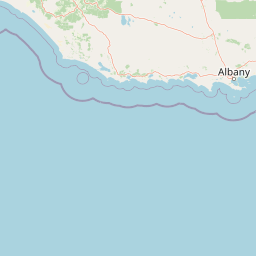
Map view of Walpole-Nornalup National Park

Use this park location map to pinpoint Walpole-Nornalup National Park in Australia, understand its exact geographic position, and read its mapped placement within the surrounding landscape more clearly.

Pigeon | © OpenStreetMap contributors

Location context for Walpole-Nornalup National Park

Western Australia
Park atlas

Trace the regional spread of diverse conservation landscapes in Western Australia.

Compare Protected Areas and National Parks Near Walpole-Nornalup National Park, Western Australia
Browse an atlas of national parks and protected areas geographically adjacent to Walpole-Nornalup National Park, revealing comparable forest ecosystems, coastal features, and biodiversity hotspots across Western Australia. Gain geographic context to compare diverse protected landscapes, understand regional conservation efforts, and trace the spread of unique tingle and karri forests beyond a single park boundary.
National parkWestern Australia

Mount Frankland South National Park: Western Australia's Protected Natural Landscape

Explore its mapped boundaries and regional geographic context.

Mount Frankland South National Park is a critical protected area defined by its unique natural landscape and mapped boundaries within Western Australia. This entry provides detailed insights into its geographic setting and the protected land it encompasses, offering a focused view for atlas exploration. Understand the park's significance as a protected natural reserve and its contribution to the regional geography of Western Australia, with a clear emphasis on mapped terrain and conservation landscapes.

Area
422.99 km²
Established
2004
IUCN
II
Relief
Mixed relief
National parkWestern Australia

Mount Frankland National Park: Explore Western Australia's Old-Growth Forested Landscape

Granite peaks and unique regional geography within a protected wilderness area.

Mount Frankland National Park in Western Australia is a protected area renowned for its exceptional old-growth karri and red tingle forests, some of the world's tallest tree species. The park's landscape is shaped by low granite hills and dramatic peaks, including the 411-meter Mount Frankland, offering expansive views across the wilderness. As a key component of the Walpole Wilderness Area, this national park provides a rich geographical context for understanding conservation and mapped natural landscapes in Southwest Australia.

Area
373.59 km²
Established
1988
IUCN
II
Relief
Upland
National parkGreat Southern

Mount Roe National Park: Detailed Protected Landscape and Geographic Exploration

Mapped boundaries and natural terrain of this national park.

Mount Roe National Park offers a distinct protected landscape for atlas exploration, situated within the geographic scope of the Great Southern region. This detail page provides a structured view of the park's mapped boundaries and its natural terrain. Understand how Mount Roe National Park contributes to the regional geography and the overall map of protected areas in Australia.

Area
1,278 km²
Established
2004
IUCN
II
Scope
Terrestrial
National park

Mount Frankland North National Park: Protected Jarrah Forest Landscape Exploration

Explore mapped boundaries and regional geography of this Western Australian national park.

Mount Frankland North National Park offers an immersive exploration of one of Western Australia's most significant Jarrah forest ecosystems. As a protected national park and integral part of the Walpole Wilderness Area, it showcases the unique character of the Southwest Australia woodlands. The park's landscape is defined by its tall Jarrah trees and undulating terrain, providing critical habitat and representing a vital conservation effort in a globally recognized biodiversity hotspot. Discover its geographic spread and protected land identity.

Area
220.69 km²
Established
2004
IUCN
II
Relief
Mountain
Watercolor illustration of a coastal landscape with green vegetation, pink rock formations, and a calm body of water
National parkWestern Australia

William Bay National Park: Mapped Protected Area in Western Australia's Geography

Explore its national park boundaries and regional landscape context.

Delve into the protected landscape of William Bay National Park, a designated national park situated within the diverse geography of Western Australia. This resource provides critical information on its mapped boundaries and its role as a protected natural area. Understand the park's specific geographic setting and its contribution to the regional atlas of conservation landscapes, essential for detailed park and landscape discovery.

Area
17.34 km²
Established
1971
IUCN
II
Visitors
238K annual
National parkWestern Australia

Shannon National Park: A Protected Landscape in Western Australia's Geography

Discover the mapped boundaries and regional park context.

Shannon National Park represents a key protected area within the vast geographic expanse of Western Australia. This entry focuses on understanding its identity as a national park, highlighting its specific landscape character and its contribution to the regional atlas. Through detailed mapping and geographic context, users can explore the protected boundaries and natural setting of Shannon National Park.

Area
525.98 km²
Established
1988
IUCN
II
Relief
Mixed relief
National parkGreat Southern

Mount Lindesay National Park: Australian National Park Protected Landscape Details

Explore mapped boundaries and regional geographic context in Great Southern.

Gain a structured understanding of Mount Lindesay National Park, a designated national park in Australia's Great Southern region. This detail view focuses on its protected landscape identity, mapped geographic features, and its place within the nation's network of conservation areas. Discover the specific terrain and regional atlas context that makes this park a distinct element of Australia's natural geography.

Area
395.73 km²
Established
2004
IUCN
II
Relief
Mountain
National parkWestern Australia

Lake Muir National Park: A Ramsar-Listed Wetland National Park in Western Australia

Explore mapped boundaries and the unique paperbark woodland landscapes.

Lake Muir National Park protects a significant portion of the Muir-Byenup System, a Ramsar-designated wetland complex in Western Australia's south-west. This national park serves as a vital habitat for waterbirds and features characteristic paperbark woodlands surrounding the large inland Lake Muir. Understanding its protected area status and mapped geographic features provides crucial insight into the region's ecological importance.

Area
96.36 km²
Established
2004
IUCN
II
Access
Access unknown

Common questions about visiting, size, designation, and location context for Walpole-Nornalup National Park

Walpole-Nornalup National Park FAQs for park facts, access, geography, and protected area context
Find quick answers about Walpole-Nornalup National Park, including protected-area facts, park geography, trail and visitor context, and how the park fits into its surrounding country and regional landscape.
MoriAtlas Explorer

Continue Your Protected Areas Search Across the Global Atlas

Deepen your exploration by continuing the structured search for national parks and protected areas worldwide. Utilize the comprehensive filtering capabilities to compare different conservation landscapes and refine your understanding of global park geography. Discover more about the distribution and characteristics of protected natural areas.

Global natural geography