

Mori Atlas logo
National parkWarrabah National Park

Discover the geographic identity and protected landscape of Warrabah National Park.

Warrabah National Park: A National Park in New South Wales with Mapped Protected Boundaries

Warrabah National Park represents a distinct protected area within the diverse geography of New South Wales, Australia. As a designated national park, its mapped boundaries are integral to understanding its role in the regional landscape. This page serves as a gateway to exploring the park's geographic context, natural terrain, and its significance as a protected landmass, offering a foundation for atlas-style discovery.

River gorgeNew South WalesBirdwatchingNational parkInland AustraliaCanoeing

Warrabah National Park

National park

Park overview

Structured park overview, official facts, and landscape profile for Warrabah National Park

Warrabah National Park park facts, protected area profile, and essential visitor context
Review the core facts for Warrabah National Park, including designation, size, terrain, visitor scale, habitats, and operating context in one park-focused overview.

About Warrabah National Park

Warrabah National Park protects a significant portion of the Namoi River as it traverses the New England region of New South Wales. The park's defining landscape feature is the spectacular gorge that the river has carved through ancient sandstone terrain, creating a deep canyon that drops 245 metres from the surrounding plateau to the river below. This dramatic topography defines the park's character and provides the context for most visitor activities and ecological diversity. The park lies approximately 371 kilometres north of Sydney, positioned between the small community of Kingstown to the east and Split Rock Dam to the west. The average elevation of the terrain stands at 759 metres, reflecting the park's position on the New England tablelands where the landscape transitions from rolling pastoral country to more rugged sandstone formations. The permanent flow of the Namoi River through the park provides a reliable water source that sustains distinctive riparian communities and creates opportunities for water-based recreation that would not be possible in the region's more ephemeral drainage systems.

Quick facts and research context for Warrabah National Park

Warrabah National Park covers 34.71 square kilometres in northern New South Wales, located west of Kingstown and east of Split Rock Dam. The terrain averages 759 metres in elevation, with the Namoi River carving a dramatic gorge through sandstone country. The park was established in 1984 under management by the NSW National Parks and Wildlife Service. Over 120 bird species have been recorded within the park boundaries.

Park context

Deeper park guide and search-rich context for Warrabah National Park

Warrabah National Park history, landscape, wildlife, and travel context
Explore Warrabah National Park through its history, landscape character, ecosystems, wildlife, conservation priorities, cultural context, and seasonal travel timing in a structured park guide built for atlas discovery and search intent.

Why Warrabah National Park stands out

Warrabah National Park is best known for the spectacular Namoi River gorge, a 15-kilometre canyon that drops 245 metres through the park's interior. This river-carved landscape creates the park's primary scenic feature and forms the heart of the visitor experience. The gorge supports distinct ecological communities adapted to the river corridor, while the surrounding ridgelines and woodland areas provide habitat for a remarkable diversity of birdlife. The combination of dramatic topography, permanent water flow, and relatively accessible wilderness makes Warrabah distinctive among New South Wales inland protected areas.

Warrabah National Park history and protected-area timeline

Warrabah National Park was established in 1984, representing a formalisation of protection for the Namoi River gorge and surrounding lands in the New England region. The creation of the park reflected growing recognition during the 1970s and early 1980s of the ecological and scenic values of New South Wales inland river systems and the need to provide formal conservation status to representative examples of the state's natural landscapes. The NSW National Parks and Wildlife Service assumed management responsibility at establishment, continuing the state government's role in protected area management that had expanded significantly throughout the twentieth century. The park's establishment protected a landscape that had historically been used for grazing and other rural activities, transitioning these lands to conservation-focused management that emphasises the preservation of natural values while providing for appropriate visitor use.

Warrabah National Park landscape and geographic character

The landscape of Warrabah National Park is defined by the dramatic gorge carved by the Namoi River through sandstone terrain. The river has incised a deep canyon that extends for approximately 15 kilometres within the park, with the gorge walls rising steeply from the water's edge to create a landscape of considerable visual impact. The underlying geology consists primarily of sandstone formations that contribute to the distinctive colouring and character of the cliff faces and ridgelines throughout the park. The terrain surrounding the gorge consists of undulating hills and ridges that form the broader catchment of the Namoi River system. The average elevation of 759 metres places the park in an elevated position within the New England region, contributing to the landscape's temperate character and seasonal weather patterns. The combination of steep gorge walls, forest-clothed slopes, and the perennial river creates a landscape of strong contrast and visual diversity.

Warrabah National Park ecosystems, habitats, and plant life

The ecological character of Warrabah National Park reflects the park's position in the New England region, where the landscape supports a mix of eucalypt woodland, riparian forest, and rocky outcrop communities. The Namoi River corridor forms the ecological heart of the park, providing permanent water that supports denser vegetation and distinct species assemblages compared to the surrounding drier woodlands. The riparian zone along the river supports trees and understorey species adapted to regular moisture availability, creating a green corridor through the more open terrain. The surrounding hills and ridges carry eucalypt-dominated woodland that grades into more open woodland on exposed ridgelines. The park's elevation and location support biodiversity values that include both temperate and semi-arid influences, creating a transitional ecological character.

Warrabah National Park wildlife and species highlights

Warrabah National Park supports remarkable bird diversity, with over 120 species recorded within its boundaries. The birdlife reflects the diverse habitats present, from the river corridor to the woodland-covered slopes and rocky ridgelines. Notable species recorded in the park include various robins, rosellas, and cockatoos, representing the characteristic bird communities of eastern Australian woodlands. Raptors are well represented, with wedge-tailed eagles frequently observed soaring above the gorge and surrounding terrain. The wren family is also present, including species that inhabit the understorey and ground layers of the woodland areas. The permanent water of the Namoi River attracts waterbirds and supports aquatic ecosystems that contribute to the overall biodiversity of the park. The combination of diverse habitats, water availability, and relatively intact vegetation communities creates conditions that support this significant bird species count.

Warrabah National Park conservation status and protection priorities

Warrabah National Park contributes to the conservation of New South Wales inland natural landscapes, protecting a representative example of the Namoi River system and associated ecosystems. The park's designation as an IUCN Category II protected area reflects its primary objective of preserving natural landscapes while allowing for appropriate visitor use and enjoyment. The protection of the Namoi River corridor is particularly significant, as permanent river systems in the New England region are relatively limited and face various pressures from agricultural and pastoral development. By protecting a substantial stretch of the river and its gorge, the park preserves riparian corridors that provide habitat connectivity and serve as biodiversity refuges. The park also contributes to the conservation of New England's woodland bird communities, with the documented presence of over 120 bird species indicating the ecological health and diversity of the protected landscape.

Warrabah National Park cultural meaning and human context

Warrabah National Park is situated in the traditional country of Aboriginal peoples, though detailed information about specific Indigenous associations with this landscape is limited in the available source material. The broader New England region contains numerous sites of Aboriginal cultural significance, and the Namoi River system would have supported traditional activities and provided resources for Indigenous communities over millennia. The park's establishment in 1984 occurred during a period of increasing recognition of Aboriginal cultural values in protected area management, though detailed documentation of cultural heritage within the park boundaries is not prominent in available sources.

Top sights and standout views in Warrabah National Park

The Namoi River gorge stands as the primary highlight of Warrabah National Park, a dramatic 15-kilometre canyon that drops 245 metres and provides spectacular scenery from various vantage points throughout the park. The river itself offers excellent opportunities for canoeing and tubing, allowing visitors to experience the gorge from water level while drifting through the canyon. Rock climbing on the sandstone cliffs provides another way to engage with the landscape, while the extensive network of walking tracks allows exploration of both the gorge floor and the ridgelines above. The exceptional bird diversity, with over 120 species recorded, makes Warrabah particularly significant for birdwatching and nature observation. The combination of dramatic topography, permanent river access, and relatively accessible wilderness creates a park that offers multiple ways to experience the New England landscape.

Best time to visit Warrabah National Park

Warrabah National Park can be visited throughout the year, though different seasons offer distinct experiences and conditions. The cooler months from autumn through to spring generally provide more comfortable conditions for active pursuits such as walking and rock climbing, while the river corridor remains accessible for canoeing during these periods. Summer months can bring hot conditions to the New England region, though the gorge may offer some shade and the river provides a refreshing element to a visit. The park's elevation at around 759 metres means that conditions are generally cooler than lower-lying areas to the west, moderating summer temperatures somewhat. Wildlife viewing opportunities are present year-round, though bird activity may be more pronounced during spring and summer months when breeding activity peaks. Visitors should check current conditions and any park alerts before planning trips, particularly during periods of flooding or park closures.
Park location guide

Geography guide, regional context, and park location map for Warrabah National Park

Warrabah National Park park geography, regions, and map view in Australia
Understand where Warrabah National Park sits in Australia through a broader geographic reading of the surrounding landscape, nearby location context, and its mapped position within the national park landscape.

How Warrabah National Park fits into Australia

Australia is a constitutional monarchy and federal parliamentary democracy comprising six states and ten territories. With a population of nearly 28 million, it is one of the world's most urbanised countries, with most people concentrated on the eastern seaboard. The country has a high Human Development Index and is known for its cultural diversity, ancient Aboriginal heritage, and unique wildlife.

Wider geography shaping Warrabah National Park in Australia

Australia occupies the entire Australian continent, the island of Tasmania, and numerous smaller islands. It is the world's flattest and driest inhabited continent, featuring vast deserts in the interior (the Outback), tropical rainforests along the eastern coast, and a coastline bordering the Indian and Pacific Oceans.

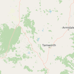
Map view of Warrabah National Park

Use this park location map to pinpoint Warrabah National Park in Australia, understand its exact geographic position, and read its mapped placement within the surrounding landscape more clearly.

Pigeon | © OpenStreetMap contributors

Location context for Warrabah National Park

New South Wales
Park atlas

Compare surrounding protected areas, mapped landscapes, and conservation zones across the New England region.

Discover Other National Parks Near Warrabah National Park and the Namoi River Gorge Region
Browse additional national parks and protected areas located near Warrabah National Park, tracing the regional spread of conservation landscapes in northern New South Wales, Australia. Compare different protected area types, geographic features, and conservation priorities to gain a comprehensive atlas view of the New England region's diverse natural terrain and river ecosystems.
National parkNew South Wales

Indwarra National Park: New South Wales National Park Protected Landscape and Geographic Context

Explore mapped park boundaries and regional geography.

Indwarra National Park is identified as a significant protected area within New South Wales, Australia, offering a unique focus for geographic exploration. As a national park, its mapped boundaries define a distinct natural landscape. This page provides detailed atlas-style information, enabling a deeper understanding of its terrain, regional context, and protected-area significance for structured discovery.

Area
9 km²
Established
1999
IUCN
Ia
Relief
Mountain
National parkNew South Wales

Single National Park National Park: A Protected Landscape within New South Wales

Explore mapped boundaries and regional geography.

Single National Park represents a vital protected area, contributing significantly to the natural landscape of New South Wales. This entry offers a deep dive into its geographic scope, detailing mapped park boundaries and the surrounding regional context. It serves as a foundational piece for understanding the park's identity as a protected natural asset and its place within Australia's broader conservation geography.

Area
25.63 km²
Established
1999
IUCN
II
Relief
Mixed relief
National parkNew South Wales

Mount Kaputar National Park: New South Wales Volcanic National Park Atlas

Explore mapped volcanic terrain and ecological diversity.

Mount Kaputar National Park offers a compelling study in protected landscape geology and ecology. Situated in New South Wales, this national park preserves the significant geological features of ancient volcanic remnants, including prominent plugs and lava terraces. Its high-elevation position supports a variety of ecosystems, making it a critical area for understanding inland Australia's natural geography and protected land patterns. Browse its mapped boundaries and discover the unique character of this volcanic wilderness.

Area
502.25 km²
Established
1959
IUCN
II
Relief
Mountain
National parkNew South Wales

Oxley Wild Rivers National Park: National Park Protected Landscape and Regional Geography

Explore mapped boundaries and natural terrain.

Oxley Wild Rivers National Park is a key protected area in New South Wales, Australia, designated as a national park. This entity provides essential geographic context, allowing for detailed exploration of its mapped boundaries and the surrounding natural landscape. Understand the park's role within the region and its contribution to a broader atlas of protected lands. Discover the specific landscape character and geographic identity that define this Australian national park.

Area
1,452.33 km²
Established
1986
IUCN
Ib
Relief
Mixed relief
National parkNew South Wales

Kings Plains National Park: National Park Protected Area and Geographic Context

Explore mapped boundaries and landscape details for this New South Wales park.

Kings Plains National Park represents a distinct protected area entity within New South Wales, Australia. This national park serves as a focal point for understanding specific geographic features and its mapped boundaries. Users engaging with this park profile can uncover its regional landscape context and explore its significance as part of a larger atlas of protected natural areas. The focus remains on its geographic identity and atlas-based discovery value.

Area
57 km²
Established
1988
IUCN
II
Access
Moderate access
National parkNew South Wales

Mummel Gulf National Park: New South Wales Protected Area & Mapped Gorge Landscape

Rugged escarpment terrain with diverse forest ecosystems.

Mummel Gulf National Park is a protected area in New South Wales, Australia, renowned for its dramatic V-shaped gorge carved by the Mummel River, reaching depths over 400 metres. This rugged escarpment landscape hosts a variety of vegetation communities, including tall open eucalypt, wet sclerophyll, snow gum forests, and subtropical rainforest patches. The park's geography is central to its ecological significance, providing habitat for numerous species and showcasing a distinct natural terrain within the New England region, ideal for geographic exploration.

Area
122 km²
Established
1999
IUCN
II
Relief
Mountain
National parkNew South Wales

Ben Halls Gap National Park: Ancient Eucalyptus Forest Protected Landscape in New South Wales

Explore mapped boundaries of old-growth woodland terrain.

Ben Halls Gap National Park represents an ecologically vital strict nature reserve within New South Wales, Australia. It is distinguished by its extensive ancient eucalyptus forests, which are among the most ecologically significant old-growth woodland environments in eastern Australia. Managed primarily for conservation and research, the park's rugged terrain provides a critical habitat refuge and a key reference ecosystem for understanding undisturbed woodland dynamics and biodiversity.

Area
30.18 km²
Established
1995
IUCN
Ia
Scope
Terrestrial
National parkNew South Wales

Cunnawarra National Park: Exploring Its Protected Landscape and Mapped Geography

New South Wales National Park Atlas Entry

Cunnawarra National Park offers a specific lens through which to understand Australia's protected areas and regional geography. This detailed entry focuses on the park's identity as a designated national park, highlighting its mapped boundaries and its place within the broader landscape of New South Wales. Users can investigate the park's natural terrain and its contribution to conservation, making it a valuable point for structured geographic discovery.

Area
158 km²
Established
1999
IUCN
II
Scope
Terrestrial

Common questions about visiting, size, designation, and location context for Warrabah National Park

Warrabah National Park FAQs for park facts, access, geography, and protected area context
Find quick answers about Warrabah National Park, including protected-area facts, park geography, trail and visitor context, and how the park fits into its surrounding country and regional landscape.
MoriAtlas Explorer

Continue Your Protected Areas Search Across the Global Atlas

Deepen your exploration by continuing the structured search for national parks and protected areas worldwide. Utilize the comprehensive filtering capabilities to compare different conservation landscapes and refine your understanding of global park geography. Discover more about the distribution and characteristics of protected natural areas.

Global natural geography