Why Waza National Park stands out
Waza National Park is best known for its substantial elephant populations that congregate at the famous Mare aux Éléphants watering hole, as well as its remaining lion population that represents one of the last viable groups in the region. The park serves as a refuge for Kordofan giraffe, a subspecies of giraffe with limited global populations, and supports significant herds of kob antelope, red-fronted gazelle, and korrigum. The Yaéré floodplain provides critical habitat for over 20,000 waterfowl throughout the year, while the diverse avifauna includes species such as the marbled duck, greater spotted eagle, and black crowned-crane. The park's position in the Sahel-Sudan transition zone creates a unique savanna ecosystem that supports species from both ecological regions.
Waza National Park history and protected-area timeline
Waza National Park traces its origins to 1934 when it was established as a hunting reserve, reflecting the colonial-era approach to wildlife management that focused on game preservation for sustainable hunting. The park underwent significant transformation in 1968 when it achieved full national park status, transitioning from a resource extraction model to one emphasizing conservation and protection. This evolution represented Cameroon\'s growing commitment to establishing a meaningful network of protected areas.
The year 1979 marked a milestone with Waza\'s designation as a UNESCO Biosphere Reserve, recognition that underscored the park\'s dual role in biodiversity conservation and ecological research. This designation came during a period of increased environmental awareness and international cooperation on conservation matters. The development of a Management Master Plan in 1997 represented another significant chapter, being the first such comprehensive management document created for any Cameroon protected area. This plan provided systematic guidance for conservation activities, resource management, and visitor use.
Management challenges have evolved substantially since the park\'s establishment. Initial staffing levels in 1983 included twenty-five rangers, but by 2005 this number had declined to just seven, creating significant vulnerabilities to poaching activities. External threats from poachers originating in Chad, Nigeria, and Cameroon itself intensified during this period. International support emerged through the Netherlands World Conservation Union Committee\'s agreement in 2005 to fund additional eco-rangers, addressing the critical shortfall in enforcement capacity. The IUCN\'s Waza-Logone Project, launched in 1994 in collaboration with Cameroon\'s Ministry of Environment, has provided ongoing support for habitat rehabilitation and management improvement.
Waza National Park landscape and geographic character
The physical geography of Waza National Park reflects its position within the Chad depression, a vast geological basin originally formed by the ancient presence of Lake Chad. The terrain is predominantly flat, with average elevations ranging between 300 and 320 meters, though the highest ground reaches approximately 500 meters near Waza village in the western portion of the park. Sand dunes scattered throughout the western areas provide visible evidence of the region\'s more arid past, remnants of desert conditions that have since given way to the current semi-arid environment.
The Yaéré floodplain represents one of the park\'s most distinctive landscape features, extending along the eastern and northeastern boundaries. This seasonally-inundated area creates a dynamic wetland environment that fills during the rainy season and supports specialized vegetation adapted to periodic flooding. The floodplain\'s hydrological cycle has been significantly altered by human activities, particularly the construction of the Maga Dam approximately 25 kilometers south of the park, which has reduced water flow to the depressions within the protected area.
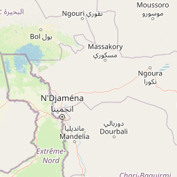
The park\'s soil formations reflect the geological history of the Chad depression, primarily consisting of tropical ferruginous soils arranged in characteristic catenas, along with hydromorphic soils in lower-lying areas and vertisols in specific zones. Heavy clays dominate the soil composition, particularly in areas subject to seasonal flooding. Land classification within the park divides the territory into terrestrial landscapes comprising 88% of the area, with shrub land at 7% and grassland at 5%. The accessibility of the park is facilitated by its proximity to Maroua, approximately 120 kilometers to the south, and Kousséri at 135 kilometers distance, both connected by paved roads.
Waza National Park ecosystems, habitats, and plant life
The ecological character of Waza National Park is defined by its position in the transition zone between the Sahel and Sudan savanna biomes, creating a unique vegetation mosaic that supports diverse habitats. The park contains five principal vegetation types, each occupying distinct ecological niches and supporting associated wildlife communities. Combretaceous shrub savanna dominates much of the park, featuring Sclerocarya birrea trees alongside Combretum and Terminalia shrubs, with the distinctive doum palm Hyphaene thebaica scattered throughout. This vegetation type provides crucial browse for elephant populations and shelter for numerous smaller species.
The Anogeissus leiocarpus woodland occurs primarily in sandy soil areas, often with Mitragyna inermis growing in pockets near temporary water bodies. The Lannea humilis open grass savanna represents another distinct habitat type, combining this species with short annual grasses across broader landscapes. The Acacia seyal tree savanna occupies areas with black clay soils that become highly saturated during the rainy season, creating challenging conditions for many plant species. Finally, the Yaéré floodplains support perennial grasses including Vetiveria nigritana, Oryza barthii, Echinochloa pyramidalis, and Echinochloa stagnina, representing critical dry-season foraging grounds for large herbivores.
The park\'s location within the Chad basin creates a semi-arid climate with average annual precipitation of approximately 700 millimeters, though rainfall is erratic in its timing and distribution. The rainy season extends from June through October, while the dry season dominates from November to May. Mean annual temperature stands at 28°C, with December minimum temperatures around 16°C and April maximum temperatures reaching 41°C just before the rains begin. These climatic conditions shape the vegetation dynamics and create the seasonal patterns of wildlife movement and congregation that characterize the park.
Waza National Park wildlife and species highlights
Waza National Park supports one of the largest mammal populations in central West Africa, with approximately 30 species documented within its boundaries. The African bush elephant represents perhaps the most iconic species, with herds regularly congregating at the famous Mare aux Éléphants watering hole. These elephants feed extensively in the Vachellia seyal shrublands, creating localized vegetation impacts that require monitoring. The elephant population occasionally creates conflicts with farmers located far from the park boundaries as they venture beyond protected areas in search of forage.
The lion population represents a significant conservation concern, with estimates of only 14 to 21 individuals surviving as of 2010, placing the species at risk of local extinction. The park has been designated a Lion Conservation Unit since 2005, recognizing its importance for regional lion conservation despite the small population. Waza also hosts one of the last remaining populations of Kordofan giraffe, a subspecies with limited global distribution, adding significant conservation value to the protected area.
Large ungulates include kob antelope, whose populations recovered to approximately 5,000 individuals by the 1990s following declines in the 1980s, as well as hartebeest, roan antelope, waterbuck, reedbuck, and various gazelle species. The red-fronted gazelle, listed as Vulnerable, has shown population increases, while the korrigum, also Vulnerable, maintains stable numbers. Smaller mammals include warthog, olive baboon, patas monkey, vervet monkey, leopard, cheetah, and the nocturnal aardvark.
The avian community is exceptionally diverse, with 379 bird species recorded including the contiguous Logone floodplain. Waterfowl populations exceed 20,000 individuals throughout the year, representing a significant regional concentration. Notable species include marbled duck, ferruginous duck, greater spotted eagle, scissor-tailed kite, lesser kestrel, Nubian bustard, quail-plover, Arabian bustard, various stork species, and the North African ostrich. Several species of global conservation concern have been recorded, including the marbled duck, ferruginous duck, greater spotted eagle, lesser kestrel, and Nubian bustard. Two amphibian species bear the park\'s name: Kassina wazae and Bufo wazae, now included in Sclerophrys xeros, reflecting the site\'s significance for endemic biodiversity.
Waza National Park conservation status and protection priorities
Waza National Park faces significant conservation challenges stemming from both historical management issues and landscape-scale environmental changes. The construction of the Maga Dam approximately 25 kilometers south of the park has fundamentally altered the hydrological regime of the Yaéré floodplain, reducing water availability in depressions critical for wildlife. This infrastructure project, designed primarily for irrigated rice agriculture, has had cascading effects on grassland quality, fisheries, and the overall carrying capacity of the floodplain ecosystem. The elimination of natural flooding cycles has particularly impacted the large herbivore populations that depend on seasonal forage opportunities.
Poaching pressure remains a persistent threat to flagship species, particularly lions, which have declined to critically low numbers. Field studies indicate that inadequate patrolling capacity has contributed to continued persecution, with estimates suggesting only approximately 40 lions may remain in the broader landscape. While IUCN standards recommend one guard per 5,000 hectares, actual staffing levels have fallen far short of this target. International support in the form of funding for additional eco-rangers has helped address some capacity gaps.
Conservation responses have focused on habitat rehabilitation through the IUCN Waza-Logone Project, which began in 1994. This initiative has created seasonal watercourses connecting the Logone River with the Logomatya River, facilitating water flows to the floodplains. Results have been encouraging, with waterfowl numbers increasing from 59,000 in 1993 to 87,000 by 1997, and fish production reaching approximately 2,000 tonnes in the late 1990s. The project has also supported improved grazing lands for local communities, creating incentives for conservation engagement.
Waza National Park cultural meaning and human context
The cultural context of Waza National Park reflects the human dimensions of conservation in a region where traditional land use practices and wildlife populations have long coexisted. Prior to the park\'s establishment, forest dwellers maintained villages within what became the protected area. The creation of the park necessitated the resettlement of these communities to the park\'s borders, an approach designed to create a social buffer against poaching while acknowledging the potential for human-wildlife conflict.
The local population maintains strong connections to the floodplain resources, having historically depended on grazing lands, fisheries, and natural product harvesting. The Waza-Logone Project has sought to incorporate these traditional uses into sustainable management frameworks, with controlled harvesting of straw and gum arabic under field trials. Approximately 100,000 livestock units utilize the floodplain pastures during the dry season, representing the integration of pastoral activities with conservation objectives.
The park\'s transboundary location places it within a broader regional context of movement and land use across Cameroon, Nigeria, and Chad. Poaching threats from all three countries reflect the challenges of managing protected areas in regions where wildlife resources span international boundaries and where economic pressures can drive illegal extraction. The management approach has increasingly recognized the need to engage local communities as stakeholders in conservation rather than simply as subjects of protection regimes.
Top sights and standout views in Waza National Park
Waza National Park offers exceptional wildlife viewing opportunities in a Sahelian savanna setting that differs dramatically from the forest parks more common in Central Africa. The elephant herds at Mare aux Éléphants provide reliable sightings of these magnificent animals, particularly during the dry season when water becomes scarce outside the managed watering points. The Kordofan giraffe population represents a rare opportunity to observe this subspecies, found in only a handful of locations across West and Central Africa. The Yaéré floodplain, especially during the dry season, concentrates vast numbers of waterfowl, creating spectacular birdwatching opportunities with species diversity exceeding 370 in the broader Waza-Logone area. The park\'s position as a transboundary protected area connecting with Nigeria\'s Chad Basin National Park creates one of the largest conservation landscapes in the Sahel region.
Best time to visit Waza National Park
The optimal time to visit Waza National Park is during the dry season from November through mid-June, when the park is open to visitors. This period coincides with the dry season when wildlife congregates around remaining water sources, making animal sightings more predictable. The months of December through April represent the peak period for wildlife viewing, as vegetation is minimal and animals must visit waterholes regularly. However, visitors should be prepared for high temperatures, with April maximum temperatures often reaching 41°C. The transition period in November and early December offers a comfortable compromise between manageable temperatures and good wildlife visibility. The rainy season from June to October makes access difficult and wildlife viewing challenging, as water becomes more widely available and animals disperse across the landscape. The park\'s operational season from November 15 to June 15 aligns with the most favorable conditions for visitors.