
Mori Atlas logo
Nature reserveWerrahänge von Frankenroda bis Falken

A canyon-like nature reserve defined by Muschelkalk cliffs and central Werra river meanders.

Werrahänge von Frankenroda bis Falken Protected Landscape and Regional River Geography

The Werrahänge von Frankenroda bis Falken stands as a significant protected area within the Thuringian district of Wartburgkreis. This nature reserve maps a dramatic river-cut valley where the Werra flows through Muschelkalk bedrock, creating steep slopes, limestone outcrops, and a diverse mosaic of forest and grassland habitats. Our atlas data details the three-dimensional terrain, from the narrow meander loops to the orchid-rich meadows and near-natural beech forests that define this regional landscape.

Werra valleyMuschelkalk cliffsbeech forestorchid-rich grasslandFFH siteNatura 2000
A stylized vector illustration of a forested limestone cliff with a small waterfall flowing into a river, set against a soft sunset sky.

Werrahänge von Frankenroda bis Falken

Nature reserve

Park overview

Structured park overview, official facts, and landscape profile for Werrahänge von Frankenroda bis Falken

Werrahänge von Frankenroda bis Falken park facts, protected area profile, and essential visitor context

Review the core facts for Werrahänge von Frankenroda bis Falken, including designation, size, terrain, visitor scale, habitats, and operating context in one park-focused overview.

About Werrahänge von Frankenroda bis Falken

The Werrahänge von Frankenroda bis Falken occupy a geologically expressive section of the Werra valley in northwestern Thuringia. The Werra river, one of the two headwater streams later forming the Weser, has here cut through the Muschelkalk edge of the Thuringian Basin, producing a compact, canyon-like reach marked by tight meanders, steep undercut slopes, gentler slip-off slopes, and prominent limestone cliffs. The protected area covers the eastern slopes of this valley from the area around Frankenroda in the south to Falken, a district of the town of Treffurt, in the north. It lies close to the border with Hesse and forms an integral part of the Eichsfeld-Hainich-Werratal Nature Park.

Administratively, the site is split between the Verwaltungsgemeinschaft Hainich-Werratal and the city of Treffurt, with only minor portions in the municipalities of Ebenshausen and Nazza. The largest share of the area, around 460 hectares or 81 percent of the total, lies within the Gemarkung of Frankenroda. Topographically it extends between roughly 209 and 382 meters in elevation and includes the ridges of the Kahn (321.7 m), Goldberg (379.8 m), Eselskopf (365.7 m), and Fuchsberg (350.2 m), whose deeply incised valleys, flatter shelves, and abrupt edges give the area its strong local relief.

The defining ecological signature of the site is a finely woven mosaic of forest and open land. Large areas are covered by near-natural beech and mixed forests dominated by European beech, while smaller but ecologically crucial areas of dry grassland, juniper heath, species-rich meadow, and rocky limestone outcrop add botanical diversity. Periodic streams descend toward the Werra at Probsteizella and in the northern part of the area, and a strongly fluctuating karst spring, the Dudelbrunnen, is present in the northeast. Cave occurrences on the Kahn and Goldberg hills are noted as geological highlights of the area. The composition of forests, cliffs, and grassland mosaics is the foundation of both the area's biodiversity and its Natura 2000 designation.

Quick facts and research context for Werrahänge von Frankenroda bis Falken

Werrahänge von Frankenroda bis Falken is a 569-hectare Natura 2000 Fauna-Flora-Habitat site (FFH code 34) located in the Wartburgkreis district of Thuringia, on the eastern slopes of the Werra valley between Frankenroda and Falken, close to Treffurt and the Hessian border. It was designated in 1999 as part of the European network established under the Habitats Directive (92/43/EEC), proposed to the European Commission by the Thuringian Ministry for the Environment in September 2000, and formally adopted as a Site of Community Importance in December 2004. The area lies between approximately 209 and 382 meters in elevation, spans the Falkener Platte and Creuzburger Werradurchbruch natural regions, and is wholly contained within the Eichsfeld-Hainich-Werratal Nature Park. It also encompasses the Probsteizella Nature Reserve, established in 1961, which protects steep Werratal limestone cliffs and light-rich orchid beech forests.

Protection and recognition

Documented protection history, terrestrial scope, and Natura 2000 records

Werrahänge von Frankenroda bis Falken Protection Status and Recognition

Terrestrial protection status for Werrahänge von Frankenroda bis Falken establishes a formal designation baseline recorded since 2008. Official records aggregate documented Natura 2000 recognition sources to provide transparent administrative context for the protected landscape.

International recognition

Protection details

Protection scope
Terrestrial
Designated year
2008
Transboundary protection
No
WDPA ID
555520195
Park context

Deeper park guide and search-rich context for Werrahänge von Frankenroda bis Falken

Werrahänge von Frankenroda bis Falken history, landscape, wildlife, and travel context

Explore Werrahänge von Frankenroda bis Falken through its history, landscape character, ecosystems, wildlife, conservation priorities, cultural context, and seasonal travel timing in a structured park guide built for atlas discovery and search intent.

Why Werrahänge von Frankenroda bis Falken stands out

The protected area is best known for its steep, canyon-like stretch of the Werra valley, where the river has cut deeply into Muschelkalk bedrock to form dramatic cliff faces, meander loops, and a mosaic of forest and open habitats. Within this setting it is particularly valued for its extensive Waldmeister beech forests, its limestone cliff and pioneer grassland vegetation, and its orchid-rich dry and semi-dry grasslands (including a notable population of the Lady's Slipper orchid). The site is also recognized for an unusually rich bat fauna and a small, regionally endemic rowan species, the pointed-leaved whitebeam, that occurs only in the Middle Werra area. Equally distinctive is the layered conservation framework, in which a European FFH site, a long-standing German Naturschutzgebiet covering the Probsteizella cliffs, and a broader Thuringian nature park all overlap, reflecting the area's importance for habitat connectivity between the Ringgau plateau, the Hainich hills, and the Werra valley.
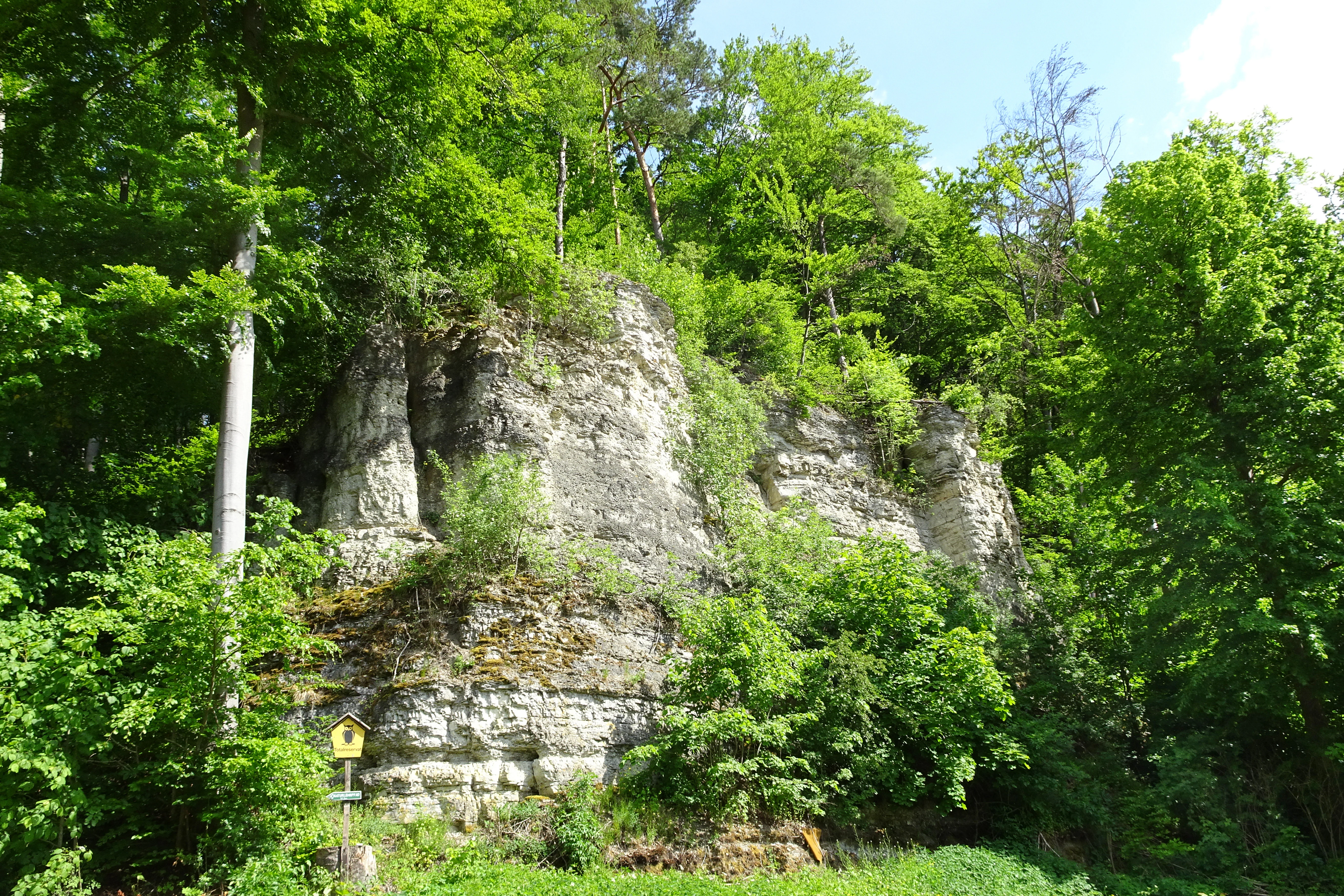
A steep, weathered limestone rock cliff face partially obscured by dense green forest foliage, with a small yellow trail sign visible near the base.
Limestone rock formation within the Probsteizella Nature Reserve, part of the Werrahänge von Frankenroda bis Falken protected area.

Werrahänge von Frankenroda bis Falken history and protected-area timeline

The conservation story of the Werrahänge began earlier than its European designation. The core of the area, the Probsteizella cliffs and slopes along the Werra, was first provisionally secured as a nature reserve between 1957 and 1961, then formally declared a Naturschutzgebiet by the GDR Minister for Agriculture and Forestry on 30 March 1961, with the definitive protection taking effect on 1 May 1961. The original purpose was to preserve the striking Werra cliffs and the light-rich orchid beech forests with their notable species inventory.

The broader valley stretch received European attention after the EU member states unanimously adopted the Habitats Directive (92/43/EEC) in 1992 to safeguard wild species and their habitats. In 1999, after years of national preparation, the Werrahänge was designated as one of Germany's nominated FFH sites. The Thuringian Ministry for the Environment proposed the area to the European Commission in September 2000 through the Federal Ministry for the Environment. The European Union confirmed its importance as a Site of Community Importance in December 2004 and incorporated it into the continental Natura 2000 network in July 2008. In Germany, the formal protection decree followed with the Thuringian Natura 2000 Conservation Objectives Ordinance of 29 May 2008. Management planning for the area was undertaken between 2016 and 2018, surveying open land under the Thuringian environment agency and forests through ThüringenForst, including the designation of two total reserves in the forest that since 2018 have been left entirely to natural development.

The wider landscape context was also given structured protection when the Eichsfeld-Hainich-Werratal Nature Park, which wholly contains the FFH site, was provisionally secured in 1990 under the GDR National Park Programme and definitively established in 2011.

Werrahänge von Frankenroda bis Falken landscape and geographic character

The Werrahänge are a textbook example of a river cutting through the Muschelkalk rim of the Thuringian Basin. The Werra has here formed a narrow, canyon-like valley squeezed between the plateau of the Ringgau to the west and the uplands of the Oberes Eichsfeld. Tight meanders alternate with steep, rocky undercut slopes and gentler slip-off slopes, producing dramatic changes over short distances. Above the river, the ridges of Kahn, Goldberg, Eselskopf, and Fuchsberg rise to between roughly 320 and 380 meters, separated by deeply incised valleys and partly walled by steep cliff edges.

Geologically, the slopes are shaped by erosion and karst processes, leaving clear geomorphological relics. Periodically dry streams run from east to west toward the Werra at Probsteizella and in the northern part of the area. In the northeast, the Dudelbrunnen is a karst spring whose flow varies considerably and sometimes ceases altogether. Caves on the Kahn and Goldberg hills are regarded as a geological highlight of the area. Together, the rock walls, narrow meander loops, forested slopes, and isolated dry grassland patches give the Werrahänge a strongly three-dimensional, almost sculptural landscape character.

Werrahänge von Frankenroda bis Falken ecosystems, habitats, and plant life

Ecologically, the Werrahänge is defined by a finely balanced mix of woodland, dry open ground, and rocky habitats. Forests cover the majority of the area, with the Waldmeister beech forest, in which European beech dominates, occupying around 300 hectares as the single largest habitat type. Smaller but ecologically significant areas include orchid-rich limestone beech forest, a small presence of mixed oak-hornbeam woodland, and relict slope and ravine mixed forest. According to Thuringia Forest data, deciduous mixed forests grow on about a third of the woodland area, with pure deciduous stands and mixed deciduous-coniferous stands making up most of the remainder. Of the woodland, 69 percent is owned by the municipality, 18 percent is state forest, and 13 percent is in private hands.

The open land component is small in extent but ecologically critical. Surveys for the management plan found about 40 hectares, roughly 6.9 percent of the protected area, covered by open habitat types. Nutrient-poor lowland hay meadows, often enriched with orchard trees, dominate the open ground and contain typical grasses such as tall oat-grass, soft brome, downy oat-grass, meadow grass, and golden oat-grass. Lime-rich rock faces above the Werra, pioneer grasslands on shallow limestone soils, juniper heath, and orchid-rich dry and semi-dry grasslands form the remaining open habitats.

Many of the dry grassland and heath patches are thought to have arisen only over the last century, after former arable fields were abandoned or after centuries of grazing on steep slopes gave way to scrub encroachment and species loss. They are therefore best understood as cultural relics of long-standing traditional land use, while the forests and cliffs reflect older natural processes.

Werrahänge von Frankenroda bis Falken wildlife and species highlights

The protected area is most notable for its bat fauna. Old, thick-trunked trees with cavities and crevices provide roosting and foraging habitat for an unusually diverse community of bat species. The Bechstein's bat, the greater mouse-eared bat, the lesser horseshoe bat, and the western barbastelle, all listed under Annex IV of the Habitats Directive and considered threatened across Europe, are confirmed residents. The site also supports the serotine bat, Brandt's bat, Natterer's bat, and the brown long-eared bat, all of which are protected under Germany's federal nature conservation law.

Beyond bats, the forests and cliffs host species that are considered characteristic and qualifying for the area's conservation value. The European wildcat is present, along with buzzards, peregrine and hobby falcons, red and black kites, black and grey-headed woodpeckers, tawny owls, the sand lizard, and the smooth snake. Among the flora, the forested and open habitats harbor numerous orchid species, most importantly rich populations of the Lady's Slipper orchid, an Annex II species of the Habitats Directive receiving special European protection. Other orchids present include the narrow-leaved helleborine, the common spotted orchid, the small-leaved helleborine, the bee orchid, several Orchis species, and the lesser butterfly-orchid. A particularly distinctive botanical element is the pointed-leaved whitebeam, a small tree endemic to northwestern Thuringia and known only from the Middle Werra region.

Werrahänge von Frankenroda bis Falken conservation status and protection priorities

The central conservation idea behind the Werrahänge is the long-term protection of a structurally rich Werra valley segment within the European Natura 2000 network. As an FFH site, the area is managed to maintain and, where necessary, restore the extensive Waldmeister beech forests, the orchid-rich limestone beech forests, the oak-hornbeam forests, and the bat species they support, alongside the pioneer grasslands of the limestone cliffs and the dry and semi-dry grasslands with their characteristic orchid populations.

The site's conservation framework is deliberately layered. At the European level, the FFH designation connects it to a continental network aimed at preserving biological diversity. At the national level, the older Probsteizella Nature Reserve, originally declared in 1961 to protect the dramatic Werra cliffs and the light-rich orchid beech forests, anchors protection in German nature conservation law. Two total forest reserves within the area have not been actively managed since 2018, allowing natural forest development. At the regional level, the entire site sits within the Eichsfeld-Hainich-Werratal Nature Park, whose broader goal is to preserve culturally shaped land-use habitats that originated through centuries of small-scale farming. This combination of habitat, species, and landscape protection gives the Werrahänge both local and European conservation significance.

Werrahänge von Frankenroda bis Falken cultural meaning and human context

Although Werrahänge is fundamentally a natural-area designation, its character cannot be separated from centuries of human land use. Many of the open habitats that contribute most of the area's botanical value, including dry and semi-dry grasslands and juniper heath, are thought to have originated only within roughly the last hundred years, after former fields were abandoned on gentler slopes. On steeper terrain, long-standing grazing pressure shaped the land for centuries before being released, allowing scrub to encroach and reducing species richness in some places. The surviving open patches are therefore best understood as cultural relics of traditional Thuringian agriculture, even where the broader landscape is shaped by the older geological history of the Werra.

Top sights and standout views in Werrahänge von Frankenroda bis Falken

The Werrahänge's strongest points of distinction are its compact juxtaposition of three things in one place: a dramatic limestone-meander landscape of the middle Werra, exceptionally well-structured beech-dominated forests, and a small but ecologically intense mosaic of dry grasslands, juniper heath, pioneer limestone grasslands, and orchid-rich meadows. Within this setting, the area combines European-level species protection (bats and the Lady's Slipper orchid), a regionally endemic tree species, and a layered protection framework in which a Natura 2000 site, an older national nature reserve, and a regional nature park reinforce one another.

Best time to visit Werrahänge von Frankenroda bis Falken

The Werrahänge can be visited year-round through its network of marked hiking trails, forest tracks, and the Werratal long-distance cycling route, both of which pass close to or through the area. Spring and early summer are the most rewarding periods for visitors interested in the meadows and dry grasslands, when the orchid-rich openings, juniper heath, and limestone pioneer grasslands display their full floral diversity. Late spring and early summer also suit bat watchers and birders, since the wooded slopes and cliff areas are most active in these months. Summer brings green, fully leafed forest cover along the meander loops, while autumn highlights the beech forests' color palette and the visual structure of the cliff-and-meander landscape. Winter visits offer clear views of the valley's geomorphology but may be limited by shorter daylight and typical Thuringian winter conditions; access is generally via the public road network and marked paths.

Monthly climate preview

Long-term representative temperature and precipitation patterns across the year

Werrahänge von Frankenroda bis Falken Climate Normals and Weather by Month

Recorded monthly climate data for Werrahänge von Frankenroda bis Falken documents a measured annual range from subzero winter minimums to warm summer maximums alongside steady daily precipitation rates. Examining the complete twelve-month record provides deeper analytical insight into the long-term meteorological baseline for this protected area.
Annual mean8 °C
-1 °C18 °C
Jan-1°
Feb
Mar
Apr
May12°
Jun16°
Jul18°
Aug18°
Sep14°
Oct
Nov
Dec
Warmest month
July

18.3 °C

Coolest month
January

-1.1 °C

Wettest month
July

2.6 mm/day

Driest month
April

1.4 mm/day

Park location guide

Geography guide, regional context, and park location map for Werrahänge von Frankenroda bis Falken

Werrahänge von Frankenroda bis Falken park geography, regions, and map view in Germany

Understand where Werrahänge von Frankenroda bis Falken sits in Germany through a broader geographic reading of the surrounding landscape, nearby location context, and its mapped position within the national park landscape.

How Werrahänge von Frankenroda bis Falken fits into Germany

Germany is a federal republic in Western and Central Europe with a population of over 83 million across sixteen constituent states. It is Europe's largest economy by nominal GDP and a major global exporter and importer. The capital is Berlin, and the country borders Denmark, Poland, Czech Republic, Austria, Switzerland, France, Luxembourg, Belgium, and the Netherlands.

Wider geography shaping Werrahänge von Frankenroda bis Falken in Germany

Germany is located in Western and Central Europe, spanning 357,022 km². It borders Denmark to the north, Poland and the Czech Republic to the east, Austria and Switzerland to the south, and France, Luxembourg, Belgium, and the Netherlands to the west. The country has coastlines on the Baltic Sea and North Sea to the north, with the Alps located in the southern region.

Map view of Werrahänge von Frankenroda bis Falken

Use this park location map to pinpoint Werrahänge von Frankenroda bis Falken in Germany, understand its exact geographic position, and read its mapped placement within the surrounding landscape more clearly.

Pigeon | © OpenStreetMap contributors

Location context for Werrahänge von Frankenroda bis Falken

Thuringia
Recorded earthquake history

Explore Historical Earthquake Records for Werrahänge von Frankenroda bis Falken

Access a documented catalogue of seismic activity identified in the vicinity of Werrahänge von Frankenroda bis Falken. This structured resource provided by MoriAtlas allows researchers and visitors to trace historical earthquake occurrences and their relative proximity to the park boundary.

Werrahänge von Frankenroda bis Falken Earthquake History

Catalogued events

4 events

Strongest magnitude

Magnitude 3.6

Most recent event

Oct 25, 2006

This history includes earthquakes recorded inside the park or within 50 km of its borders

Visualizing limestone cliffs, beech forests, and river valley habitats

Werrahänge von Frankenroda bis Falken Landscape Photography and Scenery

Photographic records illustrate the steep limestone canyons and meandering river terrain defining Werrahänge von Frankenroda bis Falken. Visual exploration reveals the complex mosaic of protected habitats, exposed rock faces, and forest canopies shaping the valley environment.

A steep, weathered limestone rock cliff face partially obscured by dense green forest foliage, with a small yellow trail sign visible near the base.

A steep, light-colored limestone cliff face rises from a lush green slope under a bright blue sky filled with scattered white clouds.

Park atlas

Compare adjacent river valleys, limestone formations, and regional nature reserves

Explore Other Parks Near Werrahänge von Frankenroda bis Falken and Surrounding Protected Landscapes

Visitors exploring Werrahänge von Frankenroda bis Falken can discover nearby protected areas and adjacent regional river valley landscapes. Examining these connected habitats provides broader geographic context for the central Werra valley ecosystem.
A wide watercolor painting depicting a landscape with green and purple trees and pale hills in the background.
Nature reserveGermany
Mapped location lies within the park boundary#1 closest

Southeast

Probsteizella Nature Reserve: A Geographical Overview of Limestone Cliffs and Forested Valleys in Germany

Mapping the Muschelkalk sequences and woodland habitats of the Werra valley.

Probsteizella is a distinctive nature reserve in Germany that showcases the dramatic geomorphology of the Werra valley. The site features the Falkener Klippen, an exposed limestone cliff face showing a full stratigraphic sequence, and the historic Bauernkanzel outcrop. This area supports a rich diversity of beech-woodland communities, providing a focused example of central German river valley protected terrain.

Area
0.269 km²
Established
1961
Relief
Upland
Climate
Temperate
Nature reserveThuringia
0 km away#2 closest

Southeast

Werra bis Treffurt mit Zuflüssen: Protected River and Floodplain Network in Thuringia

Mapping an extensive 191 kilometer Natura 2000 river corridor.

The Werra bis Treffurt mit Zuflüssen protected area serves as a vital ecological corridor in Thuringia. This site encompasses a complex mosaic of fast-flowing highland brooks, expansive floodplain meadows, inland salt sites, and rare dissolution lakes. Its geography bridges high-altitude source regions with lower river valleys, creating a distinctive landscape transect that supports essential freshwater habitats and rare aquatic species across the state.

Area
22.6 km²
Established
2008
IUCN
IV
Relief
Mixed relief
A horizontal watercolor painting depicting a soft-toned, layered landscape of rolling hills and forests in shades of green and pale yellow.
Nature reserveThuringia
0.3 km away#3 closest

West

Adolfsburg, Bornberg, Sülzenberg: A Protected Muschelkalk Landscape in Thuringia

Geographic map and protected-area atlas context

This nature reserve stands as a prominent geological feature in the Werrabergland region, where steep Muschelkalk hills and plateaus meet the Werra valley. The site protects a rare assembly of habitats including juniper heathland, scree slopes, and old-growth orchards, offering a dense case study for regional botanical diversity and limestone-terrain mapping in central Germany.

A horizontal watercolor illustration showing a landscape with rolling, misty purple hills in the background and a line of stylized green and pink trees in the foreground, with a meandering river winding through the scene.
Nature reserveThuringia
2.2 km away#4 closest

South

Creuzburger Werratal-Hänge Nature Reserve: Geography and Protected Landscape Analysis

Muschelkalk cliffs and calcareous dry grasslands in Thuringia

Located in western Thuringia, the Creuzburger Werratal-Hänge nature reserve features an intricate mosaic of cliff faces, ravine forests, and nutrient-poor dry grasslands. This protected area stands out for its high density of orchid species and mosses, all sculpted by the erosional force of the river Werra through the regional limestone bedrock.

Area
1.47 km²
Established
2000
IUCN
IV
Relief
Mountain
Nature reserveWartburgkreis
About 3.9 km away#5 closest

West

Werraaue Treffurt Nature Reserve: Geographic Overview and Protected Floodplain Map

Wartburgkreis wetland refuge and Green Belt stepping stone

Werraaue Treffurt comprises a complex riverine landscape where sediment-rich floodplain soils and restored gravel-pit lakes create a diverse sanctuary. Located near the Thuringia-Hessia state border, this nature reserve integrates into the broader Green Belt, offering significant habitat continuity for species dependent on transition zones. Its position in the Werra valley floor highlights the intersection of hydrological change, historical land-use exclusion, and modern ecological protection in Germany.

Area
0.685 km²
Established
1995
IUCN
IV
Relief
Lowland
Watercolor illustration showing a wide landscape with green rolling hills in the background, a line of trees in the midground, and a pinkish meadow with grasses in the foreground
Nature reserveHesse
3.9 km away#6 closest

Southwest

Frankenloch bei Heldra Nature Reserve: Mapped Protected Landscapes in Hesse, Germany

A rare, near-natural Werra river oxbow and wetland floodplain sanctuary.

Discover the geographic layout of Frankenloch bei Heldra, a protected nature reserve located along the River Werra. This site offers insight into floodplain dynamics, reed-bed ecology, and the restoration of natural river channels within the Werra-Meissner-Kreis district of Hesse, Germany.

Area
0.089 km²
Established
1995
Relief
Lowland
Climate
Temperate
A soft watercolor painting of a river landscape with rolling green hills and gentle slopes.
Nature reserveWartburgkreis
About 4.3 km away#7 closest

South

Lienig Nature Reserve: Protected Karst Forest Landscapes in the Wartburgkreis Region

A study of steep forested slopes and limestone gullies

Lienig acts as a crucial protected sanctuary for deciduous forest communities situated on the steep, north-facing slopes of the Werra valley. The terrain presents a complex geological profile defined by shell limestone bedrock, small-scale karst features, and deeply incised erosion ravines that support a rare assembly of spring geophytes and old-growth forest characteristics.

Area
0.225 km²
Established
1961
IUCN
IV
Relief
Upland
A soft watercolor painting showing a green landscape with a winding river and a prominent cliff face on the left, set against a white background.
Nature reserveWartburgkreis
About 4.3 km away#8 closest

South

Ebenauer Köpfe und Wisch Protected Landscape Map and Regional Geography

Nature reserve featuring Muschelkalk cliffs in the Wartburgkreis district

Analyze the geological formation and ecological importance of Ebenauer Köpfe und Wisch. This nature reserve encompasses steep canyon slopes, rare calcareous dry grasslands, and ancient rock communities essential to the Werra valley network.

Area
0.797 km²
Established
1996
IUCN
IV
Relief
Upland

Common questions about visiting, size, designation, and location context for Werrahänge von Frankenroda bis Falken

Werrahänge von Frankenroda bis Falken FAQs for park facts, access, geography, and protected area context

Find quick answers about Werrahänge von Frankenroda bis Falken, including protected-area facts, park geography, trail and visitor context, and how the park fits into its surrounding country and regional landscape.
MoriAtlas Explorer

Continue Your Protected Areas Search Across the Global Atlas

Deepen your exploration by continuing the structured search for national parks and protected areas worldwide. Utilize the comprehensive filtering capabilities to compare different conservation landscapes and refine your understanding of global park geography. Discover more about the distribution and characteristics of protected natural areas.

Global natural geography