Mori Atlas logo
National parkWild Cattle Island National Park

Discover the mapped boundaries and geographic context of this Australian national park.

Wild Cattle Island National Park: Queensland National Park and Protected Landscape Explorer

Wild Cattle Island National Park represents a significant protected area within Queensland, Australia's diverse northeastern region. As a designated national park, its mapped boundaries and geographic setting offer valuable insights for atlas-driven exploration of natural landscapes. Understanding this park's place within the Queensland geography provides critical context for appreciating Australia's protected land network and its distinct environmental character.

island national parkQueensland protected areacoastal islandAustralian national parkIUCN Category IIsubtropical island

Wild Cattle Island National Park

National park

Park overview

Structured park overview, official facts, and landscape profile for Wild Cattle Island National Park

Wild Cattle Island National Park park facts, protected area profile, and essential visitor context
Review the core facts for Wild Cattle Island National Park, including designation, size, terrain, visitor scale, habitats, and operating context in one park-focused overview.

About Wild Cattle Island National Park

Wild Cattle Island National Park protects a small island along the Queensland coast southeast of Gladstone. Established in 1992, the park spans approximately 5.8 square kilometers and is managed by the Queensland Parks and Wildlife Service under IUCN Category II designation as a national park. The island's position off the coast near Tannum Sands places it within a coastal marine context that contributes to Queensland's network of island-based protected areas. As a relatively small national park, it represents a focused conservation effort targeting the island's natural values within the broader Gladstone coastal region. The park contributes to the state's protected area coverage while providing a representative example of island conservation management in subtropical Queensland.

Quick facts and research context for Wild Cattle Island National Park

Wild Cattle Island National Park covers approximately 5.8 square kilometers (2.2 square miles) of protected island terrain in Queensland, Australia. The park is situated roughly 25 kilometers southeast of Gladstone, with the nearest accessible town being Tannum Sands on the mainland coast. Established in 1992, the park is managed by the Queensland Parks and Wildlife Service and holds IUCN Category II designation as a national park. The island's coastal position places it within a region characterized by subtropical marine environments and proximity to the Great Barrier Reef marine ecosystem.

Park context

Deeper park guide and search-rich context for Wild Cattle Island National Park

Wild Cattle Island National Park history, landscape, wildlife, and travel context
Explore Wild Cattle Island National Park through its history, landscape character, ecosystems, wildlife, conservation priorities, cultural context, and seasonal travel timing in a structured park guide built for atlas discovery and search intent.

Why Wild Cattle Island National Park stands out

Wild Cattle Island National Park is best known as a coastal island protected area in Queensland's southern coastal region. While smaller than many Australian national parks, it represents an important island conservation example within the state's protected area network. The park's island setting distinguishes it from mainland protected areas, offering a distinct coastal and potentially marine-focused conservation context within the Gladstone region.

Wild Cattle Island National Park history and protected-area timeline

Wild Cattle Island National Park was established in 1992, designated as a national park under Queensland's protected area framework. The creation of this protected area reflected a commitment to preserving the island's natural values within the state's conservation estate. Management responsibility was assigned to the Queensland Parks and Wildlife Service, which continues to oversee the park's protection and administration. The establishment of the park added a small but meaningful island component to Queensland's national park system, particularly within the coastal region near Gladstone.

Wild Cattle Island National Park landscape and geographic character

Wild Cattle Island presents a coastal island landscape characterized by its island terrain and proximity to the Queensland mainland. The island's relatively compact 5.8-square-kilometer area encompasses typical coastal island topography including shoreline features, coastal vegetation zones, and potentially interior habitats depending on the island's specific geography. The park's location approximately 25 kilometers southeast of Gladstone places it within a coastal region influenced by subtropical marine conditions. The surrounding marine environment connects to the broader Great Barrier Reef ecosystem region, though the island itself sits within more nearshore waters near Tannum Sands.

Wild Cattle Island National Park ecosystems, habitats, and plant life

As a coastal island protected area in subtropical Queensland, Wild Cattle Island National Park encompasses island-based natural systems including coastal vegetation communities, shoreline habitats, and potentially interior forest or shrubland depending on the island's specific ecological character. The park's island setting creates distinct ecological conditions influenced by marine proximity, salt exposure, and the limited area typical of island environments. Queensland's coastal islands often support specialized plant communities adapted to island conditions, including coastal dune vegetation, beach communities, and inland forest or woodland types. The surrounding marine environment adds another dimension to the park's natural values.

Wild Cattle Island National Park wildlife and species highlights

Wild Cattle Island National Park likely supports coastal and island-adapted wildlife species typical of Queensland's nearshore islands. Coastal islands in this region commonly provide habitat for seabirds, shorebirds, and marine-influenced faunal communities. The island's protected status helps preserve these wildlife values within a conservation context. While specific species details are limited in available sources, the park's coastal island position suggests it serves as important habitat for bird species utilizing coastal and marine environments, as well as any island-dwelling fauna present on the landmass.

Wild Cattle Island National Park conservation status and protection priorities

Wild Cattle Island National Park holds IUCN Category II designation as a national park, reflecting its status as a protected area managed primarily for ecosystem conservation and protection. The park's establishment in 1992 contributed to Queensland's protected area network by preserving a coastal island within the state's conservation estate. The island's relatively small size makes it a focused conservation unit, targeting the preservation of island-specific natural values within the Gladstone coastal region. This protected area contributes to the broader Queensland strategy of maintaining representative examples of diverse landscape types, including coastal island environments.

Wild Cattle Island National Park cultural meaning and human context

No specific cultural heritage information is available for Wild Cattle Island in the source material. The park's cultural context therefore remains unsupported by available documentation, and this field is left null to avoid speculation.

Top sights and standout views in Wild Cattle Island National Park

Wild Cattle Island National Park stands as a small but distinctive coastal island protected area in Queensland's southern coastal region. Its establishment in 1992 added an island conservation component to the state's national park system near Gladstone. The park protects approximately 5.8 square kilometers of island terrain within a coastal marine context. As an IUCN Category II protected area, it represents formal recognition of the island's natural values and contributes to Queensland's protected area coverage across diverse landscape types including coastal island environments.

Best time to visit Wild Cattle Island National Park

Visitors to Wild Cattle Island National Park would typically consider Queensland's subtropical climate when planning trips. The region's warm temperatures and seasonal rainfall patterns influence visitor conditions throughout the year. Generally, the cooler winter months from May to September offer more comfortable conditions for outdoor activities in Queensland's coastal areas, while summer months from November to March bring warmer temperatures and higher rainfall. The park's island setting and coastal position mean that weather conditions can include coastal breezes and typical Queensland weather patterns. Visitors seeking to explore the island should consider seasonal factors appropriate to the Gladstone region's subtropical coastal environment.

Park location guide

Geography guide, regional context, and park location map for Wild Cattle Island National Park

Wild Cattle Island National Park park geography, regions, and map view in Australia
Understand where Wild Cattle Island National Park sits in Australia through a broader geographic reading of the surrounding landscape, nearby location context, and its mapped position within the national park landscape.

How Wild Cattle Island National Park fits into Australia

Australia is a constitutional monarchy and federal parliamentary democracy comprising six states and ten territories. With a population of nearly 28 million, it is one of the world's most urbanised countries, with most people concentrated on the eastern seaboard. The country has a high Human Development Index and is known for its cultural diversity, ancient Aboriginal heritage, and unique wildlife.

Wider geography shaping Wild Cattle Island National Park in Australia

Australia occupies the entire Australian continent, the island of Tasmania, and numerous smaller islands. It is the world's flattest and driest inhabited continent, featuring vast deserts in the interior (the Outback), tropical rainforests along the eastern coast, and a coastline bordering the Indian and Pacific Oceans.

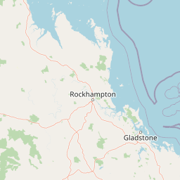
Map view of Wild Cattle Island National Park

Use this park location map to pinpoint Wild Cattle Island National Park in Australia, understand its exact geographic position, and read its mapped placement within the surrounding landscape more clearly.

Pigeon | © OpenStreetMap contributors

Location context for Wild Cattle Island National Park

Queensland
Park atlas

Trace adjacent coastal protected areas and explore broader Queensland conservation landscapes by mapping parks in the region.

Discover Other National Parks and Protected Areas Near Wild Cattle Island National Park
Browse other national parks and protected areas near Wild Cattle Island National Park, exploring the diverse coastal and island landscapes of Queensland. Comparing these protected areas offers insights into regional conservation efforts and the varied geographic terrain surrounding this notable island park.
National parkQueensland

Castle Tower National Park: Queensland National Park with Granite Peaks and Woodland

Mapped terrain and protected landscape in the Gladstone Region.

Castle Tower National Park in Queensland represents a significant protected natural area characterized by striking granite peak formations and expansive eucalypt woodlands. Established in 1932, the park's rugged terrain, including Mount Stanley, offers a unique geographic perspective within Central Queensland. This national park provides an opportunity to explore its mapped boundaries and distinctive landscape context, distinguishing it as a notable protected area in the Gladstone Region.

Area
49.8 km²
Established
1932
IUCN
II
Relief
Mountain
Watercolor illustration showing green trees and distant hills under a pastel sky
National parkQueensland

Eurimbula National Park: Central Queensland's Diverse Coastal Protected Landscape

Explore mapped terrain and protected ecosystem boundaries.

Eurimbula National Park in Queensland is an exceptional example of a protected coastal wilderness, featuring a remarkable array of habitats including mangroves, littoral rainforests, and extensive paperbark wetlands. Its diverse landscape supports significant biodiversity and offers a clear representation of central Queensland's natural heritage. Understanding Eurimbula National Park's geography through its mapped protected area helps situate its ecological importance within the broader Australian atlas.

Area
125 km²
Established
1977
IUCN
II
Relief
Lowland
National parkQueensland

Curtis Island National Park: National Park Protected Area in Queensland, Australia

Explore its mapped landscape and regional geography.

Curtis Island National Park is a designated national park offering a distinct protected landscape within Queensland, Australia. This atlas-focused entry details its geographic setting and mapped boundaries, providing essential context for understanding its place within the natural terrain of northeastern Australia. It serves as a key reference for exploring the park's specific regional geography and protected-area identity.

Area
15.5 km²
Established
1909
IUCN
II
Relief
Lowland
National parkQueensland

Rundle Range National Park: Queensland's National Park Protected Landscape Exploration

Explore its mapped boundaries and regional geographic context.

Delve into the protected landscape of Rundle Range National Park, a designated national park situated within Queensland, Australia. This entry provides focused insights into its geographic setting, mapped park boundaries, and its significance as a protected area. It is designed to aid in understanding the park's specific natural context and its place within the broader Queensland regional geography for detailed atlas discovery.

Area
21.7 km²
Established
1993
IUCN
II
Scope
Terrestrial
National parkQueensland

Mount Colosseum National Park: Queensland's Premier Protected Landscape Discovery

Mapped natural terrain and regional geographic context.

Mount Colosseum National Park offers a detailed view into Australia's protected natural areas, specifically within the state of Queensland. This entry focuses on its identity as a national park, providing essential context for its mapped boundaries, surrounding regional geography, and the unique character of its natural landscape. It serves as a key reference for understanding the park's protected status and geographic significance.

Area
8.4 km²
Established
1977
IUCN
II
Relief
Mountain
National parkQueensland

Deepwater National Park: Queensland National Park Geography and Protected Landscape

Explore mapped boundaries and regional geographic context.

Deepwater National Park represents a vital point of discovery within Queensland's extensive geography. As a designated national park, it provides crucial insights into protected landscape identity and mapped features. This page serves as a focused entry for understanding the park's specific geographic setting and its contribution to the atlas of Australian protected areas, offering a clear view of its distinct regional context.

Area
43.9 km²
Established
1988
IUCN
II
Relief
Lowland
National parkQueensland

Kroombit Tops National Park: Protected Landscape and Queensland Geography Atlas

Explore mapped terrain and regional park context in Australia.

This entry for Kroombit Tops National Park details its role as a protected natural area within Queensland, Australia. Users can engage with its geographic setting, understand its mapped boundaries, and explore its place within the regional landscape. This resource supports discovery through an atlas lens, focusing on the park's specific terrain and its contribution to the broader protected areas of northeastern Australia. It is designed for users interested in the geographic identity and mapped context of natural conservation areas.

Area
74.6 km²
Established
1974
IUCN
II
Relief
Upland
National parkQueensland

Bulburin National Park: Central Queensland's Significant Subtropical Rainforest Preserve

Mapped protected landscape and ecological refuge.

Bulburin National Park represents the most substantial remaining area of subtropical rainforest in central Queensland, established as a protected national park. Its dense forest ecosystem provides crucial habitat for numerous species, including endangered marsupials and notable birdlife. Exploring Bulburin National Park reveals a distinct natural landscape within Queensland, offering insights into regional conservation and the geographic distribution of vital protected areas.

Established
2015
IUCN
II
Relief
Lowland
Climate
Subtropical

Common questions about visiting, size, designation, and location context for Wild Cattle Island National Park

Wild Cattle Island National Park FAQs for park facts, access, geography, and protected area context
Find quick answers about Wild Cattle Island National Park, including protected-area facts, park geography, trail and visitor context, and how the park fits into its surrounding country and regional landscape.
MoriAtlas Explorer

Continue Your Protected Areas Search Across the Global Atlas

Deepen your exploration by continuing the structured search for national parks and protected areas worldwide. Utilize the comprehensive filtering capabilities to compare different conservation landscapes and refine your understanding of global park geography. Discover more about the distribution and characteristics of protected natural areas.

Global natural geography