

Mori Atlas logo
National parkWilderness National Park

Understand the mapped boundaries and regional context of this national park.

Wilderness National Park: Protected Landscape and Geography in South Africa's Western Cape

Wilderness National Park is a key protected area situated within the diverse geography of South Africa's Western Cape province. This page offers an atlas-style view of the park, detailing its precise protected boundaries and situating it within the broader regional landscape. Explore the geographic significance of Wilderness National Park as a designated national park contributing to the conservation of natural terrains.

Coastal Protected AreaWetlandsIndigenous ForestFynbosRamsar SiteBirdwatching

Wilderness National Park

National park

Park overview

Structured park overview, official facts, and landscape profile for Wilderness National Park

Wilderness National Park park facts, protected area profile, and essential visitor context
Review the core facts for Wilderness National Park, including designation, size, terrain, visitor scale, habitats, and operating context in one park-focused overview.

About Wilderness National Park

Wilderness National Park occupies a distinctive position along South Africa's southern coastline, where the mountainous interior of the Cape meets the Indian Ocean. The protected area creates a缓冲区 around the town of Wilderness, linking coastal dunes and beaches with inland forest and wetland systems. The park's geography is defined by water, with the Touws River flowing from the mountains through a series of lakes before reaching the sea at the Wilderness estuary. This hydrological corridor supports a remarkable variety of habitats within a relatively compact area, from fynbos-covered slopes to silent forest groves and productive wetlands. The park forms part of the greater Garden Route, a region renowned for its natural beauty and ecological diversity, and functions as a critical conservation node within this broader landscape. Visitors experience a landscape where dense indigenous forest coexists with open fynbos, where still lakes mirror the sky, and where the calls of endemic birds echo through the trees.

Quick facts and research context for Wilderness National Park

Wilderness National Park covers approximately 1,210 square kilometers along South Africa's southern coast. The protected area encompasses three major zones of indigenous forest, four distinct types of fynbos vegetation, and a system of interconnected lakes including Eilandvlei, Langvlei, and Rondevlei. These lakes, together with the Touws River estuary, have been designated as a Ramsar site, recognizing their international importance as wetlands. The park was officially proclaimed in 1987 and became part of the Garden Route National Park in 2008.

Park context

Deeper park guide and search-rich context for Wilderness National Park

Wilderness National Park history, landscape, wildlife, and travel context
Explore Wilderness National Park through its history, landscape character, ecosystems, wildlife, conservation priorities, cultural context, and seasonal travel timing in a structured park guide built for atlas discovery and search intent.

Why Wilderness National Park stands out

Wilderness National Park is best known for its exceptional coastal wetland system and the rare Knysna seahorse, one of the world's most endangered seahorse species. The park protects critical habitat for this endemic species within its estuarine environments. The interconnected lake system formed by the Touws River, featuring Eilandvlei, Langvlei, and Rondevlei, represents a unique hydrological system that supports diverse aquatic life and migratory waterbirds. The ancient Woodville Big Tree, estimated to be over 800 years old, stands as a living landmark within the park's forest zones.

Wilderness National Park history and protected-area timeline

The conservation history of the Wilderness area began in 1968 when authorities recognized the ecological importance of the lakes system and initiated protection measures. At that time, approximately 450 hectares around the Touws River mouth, including two lakes and the Duiwerivier Kloof, were identified for conservation. The Lake Areas Development Board managed these protected lands until 1985, when responsibility transferred to the National Parks Board. This transition marked a new era for the region's protection. Wilderness National Park was officially proclaimed in 1987, establishing formal national park status for the area. In 2008, the park was integrated into the newly established Garden Route National Park, becoming part of a larger coordinated conservation effort spanning the entire Garden Route region.

Wilderness National Park landscape and geographic character

The physical landscape of Wilderness National Park presents a varied terrain shaped by the interaction of river systems, coastal processes, and mountainous terrain. The Touws River descends from the inland mountains to create a series of three interconnected lakes: Eilandvlei, Langvlei, and Rondevlei, each with distinct characters and ecological functions. These water bodies drain through wetlands before reaching the Eilandvlei estuary and eventually the Indian Ocean. The park protects three major zones of indigenous forest, where tall trees create cathedral-like canopies over the forest floor. Between the forest zones, patches of fynbos cover the slopes, representing four distinct types of this uniquely Cape vegetation characterized by fine-leaved shrubs and seasonal wildflower displays. The coastal margin features estuary environments where fresh and salt water mix, creating productive brackish habitats supporting specialized species.

Wilderness National Park ecosystems, habitats, and plant life

The ecological character of Wilderness National Park reflects its position within the Cape Floristic Region, one of the world's six floral kingdoms and the smallest and most threatened. The park protects four types of fynbos vegetation, the distinctive Cape scrubland vegetation adapted to the region's Mediterranean climate and nutrient-poor soils. These fynbos communities support remarkable plant diversity, including numerous endemic species found nowhere else on Earth. The indigenous forests within the park represent some of the last remaining patches of this once-extensive forest type along the southern coast. The lake system, designated as a Ramsar site of international importance, forms the ecological heart of the park. These wetlands serve as critical habitat for waterbirds, support aquatic species, and function as natural water filters and flood buffers. The estuarine environments where rivers meet the sea create unique brackish conditions that harbor specialized species adapted to varying salinity levels.

Wilderness National Park wildlife and species highlights

The wildlife of Wilderness National Park reflects the park's diverse habitats, from forest canopies to wetland margins and coastal waters. The Knysna seahorse represents the park's most celebrated resident, an endangered species found only in this region and dependent on the estuary and lake environments for its survival. The pansy shell, a distinctive sea urchin with vibrant coloring, inhabits the coastal waters. Birdlife is particularly abundant, with the pied kingfisher a common sight along waterways, the Knysna lourie (also known as the knysna turaco) haunting the forest canopy with its striking plumage and haunting calls, while grey herons and little egrets stalk the wetland margins. This avifauna community includes both forest-dwelling species and water-associated birds, making the park a rewarding destination for birdwatchers.

Wilderness National Park conservation status and protection priorities

Wilderness National Park plays a significant role in South Africa's conservation landscape, protecting critical habitat for several endangered and endemic species. The designation of the lake system as a Ramsar site acknowledges the international importance of these wetlands under the Ramsar Convention on Wetlands, committing South Africa to their wise use and conservation. The park protects the Knysna seahorse, ranked among the world's most threatened seahorse species, within its protected boundaries. By joining the Garden Route National Park in 2008, Wilderness became part of a larger integrated conservation initiative that coordinates management across the broader Garden Route region, connecting fragmented habitats and strengthening conservation outcomes across landscape scales.

Wilderness National Park cultural meaning and human context

The cultural landscape of Wilderness National Park includes traces of human history that predate formal protection. The Goudveld area within the park preserves remnants of an old mining town, evidence of early European settlement and resource extraction in the forest regions. The Woodville Big Tree, believed to be over 800 years old, stands as a natural monument connecting the present to centuries of history, having witnessed the changes that transformed this landscape from indigenous occupation through colonial settlement to modern conservation. These cultural elements add depth to the park's identity, showing how human communities have interacted with this landscape over time.

Top sights and standout views in Wilderness National Park

The interconnected lake system of Eilandvlei, Langvlei, and Rondevlei forms the centerpiece of the park, offering paddling opportunities through tranquil waters surrounded by forest and fynbos. The ancient Woodville Big Tree provides a tangible connection to the park's deep past, its massive trunk a reminder of the ancient forests that once covered this region. The estuary and coastal waters support the endangered Knysna seahorse, a conservation priority that makes this park globally significant for marine biodiversity. The blend of indigenous forest, fynbos, wetlands, and coast creates a compact but remarkably diverse landscape where visitors can experience multiple ecosystems within a single protected area.

Best time to visit Wilderness National Park

The park can be visited throughout the year, with each season offering different experiences. The summer months from November to March bring warmer temperatures and longer days ideal for paddling, hiking, and outdoor activities on the water. The fynbos typically blooms during spring and early summer, displaying colorful wildflower displays across the shrubland areas. Winter months from June to August bring cooler conditions and increased rainfall, which sustains the lake system and creates lush green landscapes. Birdwatching is rewarding year-round, though migratory waterbirds are most present during the southern hemisphere summer.
Park location guide

Geography guide, regional context, and park location map for Wilderness National Park

Wilderness National Park park geography, regions, and map view in South Africa
Understand where Wilderness National Park sits in South Africa through a broader geographic reading of the surrounding landscape, nearby location context, and its mapped position within the national park landscape.

How Wilderness National Park fits into South Africa

South Africa is the southernmost country in Africa, spanning 1.22 million km² with a population of over 63 million. The country operates with three capital cities, Pretoria (executive), Cape Town (legislative), and Bloemfontein (judicial), and is renowned for its biodiversity, national parks, and multicultural society.

Wider geography shaping Wilderness National Park in South Africa

South Africa occupies the southernmost region of Africa, with coastline along both the Atlantic Ocean to the west and the Indian Ocean to the east. The interior features elevated plateaus including the Highveld, with the Drakensberg escarpment marking the eastern highlands. The country shares borders with Namibia, Botswana, Zimbabwe, Mozambique, Eswatini, and Lesotho.

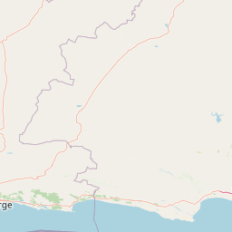
Map view of Wilderness National Park

Use this park location map to pinpoint Wilderness National Park in South Africa, understand its exact geographic position, and read its mapped placement within the surrounding landscape more clearly.

Pigeon | © OpenStreetMap contributors

Location context for Wilderness National Park

Western Cape
Park atlas

Trace the geographic spread of protected areas in South Africa's Western Cape, focusing on the Garden Route's diverse ecosystems.

Compare Nearby National Parks, Protected Areas, and Connected Landscapes Around Wilderness National Park
After exploring Wilderness National Park, discover other national parks and protected areas located throughout South Africa's Western Cape province. Compare diverse coastal protected landscapes and trace the geographic spread of conservation efforts within the broader Garden Route region.
National parkSouth Africa

Garden Route National Park: South Africa's Protected Landscape and Forest Atlas

Explore indigenous forests, coastal cliffs, and lake systems.

Garden Route National Park is a key national park in South Africa, celebrated for its rich indigenous forests and dramatic coastline. As a protected landscape, it offers a unique geographic profile, blending ancient woodlands with rugged coastal terrain and interconnected lake systems. This page serves as an atlas entry, detailing the park's spatial extent and its significance as a conservation area within the broader geography of South Africa.

Area
1,210 km²
Established
2009
IUCN
II
Relief
Mixed relief
National parkSouth Africa

Tsitsikamma National Park: South Africa's Protected Coastal Forest and Terrain

Explore the unique mapped landscape and protected area boundaries.

Tsitsikamma National Park in South Africa is defined by its striking coastal geography, where ancient indigenous forests descend towards rugged shores. This national park is a prime example of a protected landscape that showcases the dynamic interface between land and sea, featuring dramatic cliffs and iconic river mouths. Understanding its mapped boundaries and diverse terrain provides critical context for regional geographic exploration and the study of conservation areas within South Africa.

Established
2009
IUCN
II
Relief
Mixed relief
Climate
Mediterranean
Wildlife reserveWestern Cape

Karoo National Park Wildlife Reserve: Mapped Boundaries and Geographic Context

Explore the protected landscape of this Western Cape wildlife reserve.

Karoo National Park stands as a protected wildlife reserve, offering insights into the natural geography of South Africa's Western Cape. This detail page provides an atlas view of its protected landscape, mapping its boundaries and situating it within its regional context. Engage with the park's identity as a conservation area and understand its geographic significance for dedicated exploration.

Area
767.9 km²
Established
1979
Relief
Mountain
Climate
Arid
National parkEastern Cape

Camdeboo National Park: Protected Landscape Atlas and Eastern Cape Geographic Context

Discover the mapped geography and protected area identity of this Eastern Cape national park.

Camdeboo National Park represents a key protected landscape within the Eastern Cape province of South Africa. This entry provides essential details for understanding its protected-area status, geographic footprint, and its role within the regional atlas. Examine its mapped boundaries and explore the unique natural terrain it encompasses, gaining specific insight into its protected landscape characteristics.

Area
194.05 km²
Established
2005
Relief
Mountain
Climate
Arid
National parkEastern Cape

Addo Elephant National Park: South African National Park with Diverse Protected Landscapes

Explore its geographic context and unique Big Seven megafauna habitats.

Addo Elephant National Park is a crucial protected landscape within South Africa's Eastern Cape, covering approximately 1,640 square kilometers of varied terrain including karoo plains, coastal dunes, and marine protected areas. Its identity is deeply tied to the successful recovery of elephant populations and its distinction as the only African national park where all Big Seven megafauna can be observed in their natural surroundings. Discover the park's geographic spread, landscape diversity, and its role as a premier conservation area.

Area
1,640 km²
Established
1931
IUCN
II
Visitors
305.5K annual
National parkWestern Cape

Bontebok National Park: A Unique Protected Landscape in South Africa's Western Cape

Mapping the endemic bontebok's habitat and diverse fynbos.

Bontebok National Park represents a singular achievement in conservation, dedicated to protecting the rare bontebok antelope and showcasing the extraordinary biodiversity of the Cape Floristic Region. Located in the Western Cape, this smallest of South Africa's national parks features a landscape of fynbos-covered foothills beneath the Langeberg Mountains, with the Breede River defining its southern edge. Explore its mapped boundaries and unique ecosystems, offering a concentrated natural discovery experience within a UNESCO World Heritage Site.

Area
27.86 km²
Established
1931
IUCN
II
Relief
Mixed relief
National parkEastern Cape

Mountain Zebra National Park: A National Park within Eastern Cape's Geography

Explore its mapped protected boundaries and regional landscape context.

Mountain Zebra National Park serves as a key protected area within South Africa's Eastern Cape region. This page offers an atlas-driven perspective, detailing the park's geographic scope and mapped boundaries. Understand its role as a national park and its contribution to the regional landscape context, providing structured data for those interested in protected land distribution and natural terrain.

Area
284 km²
Established
1937
IUCN
II
Visitors
31.2K annual
National parkWestern Cape

Agulhas National Park: National Park Protected Landscape and Geographic Atlas

Mapped boundaries and regional geography in Western Cape.

Agulhas National Park is a protected national park in South Africa's Western Cape, vital for understanding regional geography and mapped landscape features. This entry focuses on its identity as a conservation area, detailing its protected landscape context and geographic setting within the broader atlas of Southern Africa. Explore the specific park boundaries and the unique terrain that defines this significant natural area.

Area
209.59 km²
Established
1998
IUCN
II
Relief
Lowland

Common questions about visiting, size, designation, and location context for Wilderness National Park

Wilderness National Park FAQs for park facts, access, geography, and protected area context
Find quick answers about Wilderness National Park, including protected-area facts, park geography, trail and visitor context, and how the park fits into its surrounding country and regional landscape.
MoriAtlas Explorer

Continue Your Protected Areas Search Across the Global Atlas

Deepen your exploration by continuing the structured search for national parks and protected areas worldwide. Utilize the comprehensive filtering capabilities to compare different conservation landscapes and refine your understanding of global park geography. Discover more about the distribution and characteristics of protected natural areas.

Global natural geography