Mori Atlas logo
Nature reserveWildpferdebahn

A mosaic of heath, moor, and forest preserving unique horse populations in Germany

Wildpferdebahn Nature Reserve and the Protected Landscapes of the Merfelder Bruch Region

The Wildpferdebahn serves as a significant nature protection area in the Münsterland region of Nordrhein-Westfalen, Germany. This reserve safeguards a complex mosaic of moor, dry heath, and alder woodland habitats, providing an enclosed range for a historic herd of semi-feral Dülmener horses. As the last surviving site of the traditional Westphalian Wildbahn in Central Europe, the protected terrain offers rare insight into a landscape managed through both private stewardship and formal ecological conservation.

wild horse reservesemi-feral horsesDülmener WildpferdWestphalian WildbahnMünsterlandMerfelder Bruch

Wildpferdebahn

Nature reserve

Park overview

Structured park overview, official facts, and landscape profile for Wildpferdebahn im Merfelder Bruch

Wildpferdebahn im Merfelder Bruch park facts, protected area profile, and essential visitor context

Review the core facts for Wildpferdebahn im Merfelder Bruch, including designation, size, terrain, visitor scale, habitats, and operating context in one park-focused overview.

About Wildpferdebahn im Merfelder Bruch

The Wildpferdebahn in the Merfelder Bruch is a privately owned semi-feral horse reserve set within an officially protected landscape near Dülmen in the Münsterland region of North Rhine-Westphalia. Although it functions as a nature reserve and a registered Naturschutzgebiet, its central focus is not a population of truly wild equids but rather a managed population of Dülmener Wildpferde, a hardy German pony breed kept under conditions that closely mimic a wild existence.

The protected landscape combines open pasture, moorland, dry heath, birch scrub, and patches of mature forest dominated by oak and conifers. Within this varied environment, the horses live outside throughout the year, develop a thick winter coat, find natural shelter in the woodlands, and survive largely without human veterinary or feeding intervention. Only during severe frost and snow is supplementary hay provided at a few feeding points, and the herd is otherwise left to natural selection.

Visitors encounter the reserve as both a working landscape and a cultural institution. In addition to observing the horses grazing in their natural setting, guests can witness the annual roundup, the Wildpferdefang, which has become one of the most recognizable traditional events associated with the reserve. Together, the dual identity of ecological protection area and hereditary living tradition of the Dukes of Croÿ gives the Wildpferdebahn a distinctive profile that sets it apart from typical national park destinations.

Quick facts and research context for Wildpferdebahn im Merfelder Bruch

The Wildpferdebahn lies in the Merfelder Bruch near Dülmen in the Münsterland, North Rhine-Westphalia, in northwestern Germany. The fenced reserve covers roughly 360 hectares of the larger former Merfelder Bruch landscape, while the surrounding nature protection area established in 1956 covers about 291 hectares between the villages of Maria Veen and Merfeld. A separate historical fenced grazing area within the Bruch extends over roughly 500 hectares in total and supports an average herd of around 400 Dülmener horses including foals.

The reserve is the only surviving Wildbahn of its kind in Central Europe, having been saved from the decline that wiped out other Westphalian wild horse areas in the early twentieth century through the action of the Dukes of Croÿ. It is also a working cultural institution, hosting the annual Wildpferdefang on the last Saturday in May, when yearling stallions are rounded up by hand for chipping, lottery, and auction.

Protection and recognition

Examine the verified protection scope and official designation records for Wildpferdebahn.

Wildpferdebahn Protection Status and Terrestrial Conservation Recognition

Wildpferdebahn maintains a documented terrestrial protection scope within established conservation frameworks. Official records aggregate available international designations and management parameters to outline the legal status.

Protection details

Protection scope
Terrestrial
Park context

Deeper park guide and search-rich context for Wildpferdebahn im Merfelder Bruch

Wildpferdebahn im Merfelder Bruch history, landscape, wildlife, and travel context

Explore Wildpferdebahn im Merfelder Bruch through its history, landscape character, ecosystems, wildlife, conservation priorities, cultural context, and seasonal travel timing in a structured park guide built for atlas discovery and search intent.

Why Wildpferdebahn im Merfelder Bruch stands out

The Wildpferdebahn is best known as the home of the Dülmener Wildpferd, a small, primitive-looking horse breed whose herd has been maintained in a semi-feral state in the Merfelder Bruch for generations. It is celebrated as the last true wild horse range in Central Europe, attracting visitors and horse enthusiasts who come to see the animals grazing freely across pasture, moor, heath, and forest. Equally distinctive is the annual Wildpferdefang, a traditional roundup held every last Saturday in May in which experienced catchers separate the yearling stallions from the herd by hand. This event is one of the reserve's most recognizable traditions and a defining element of the park's identity, combining conservation management of the herd with a long-standing cultural spectacle.
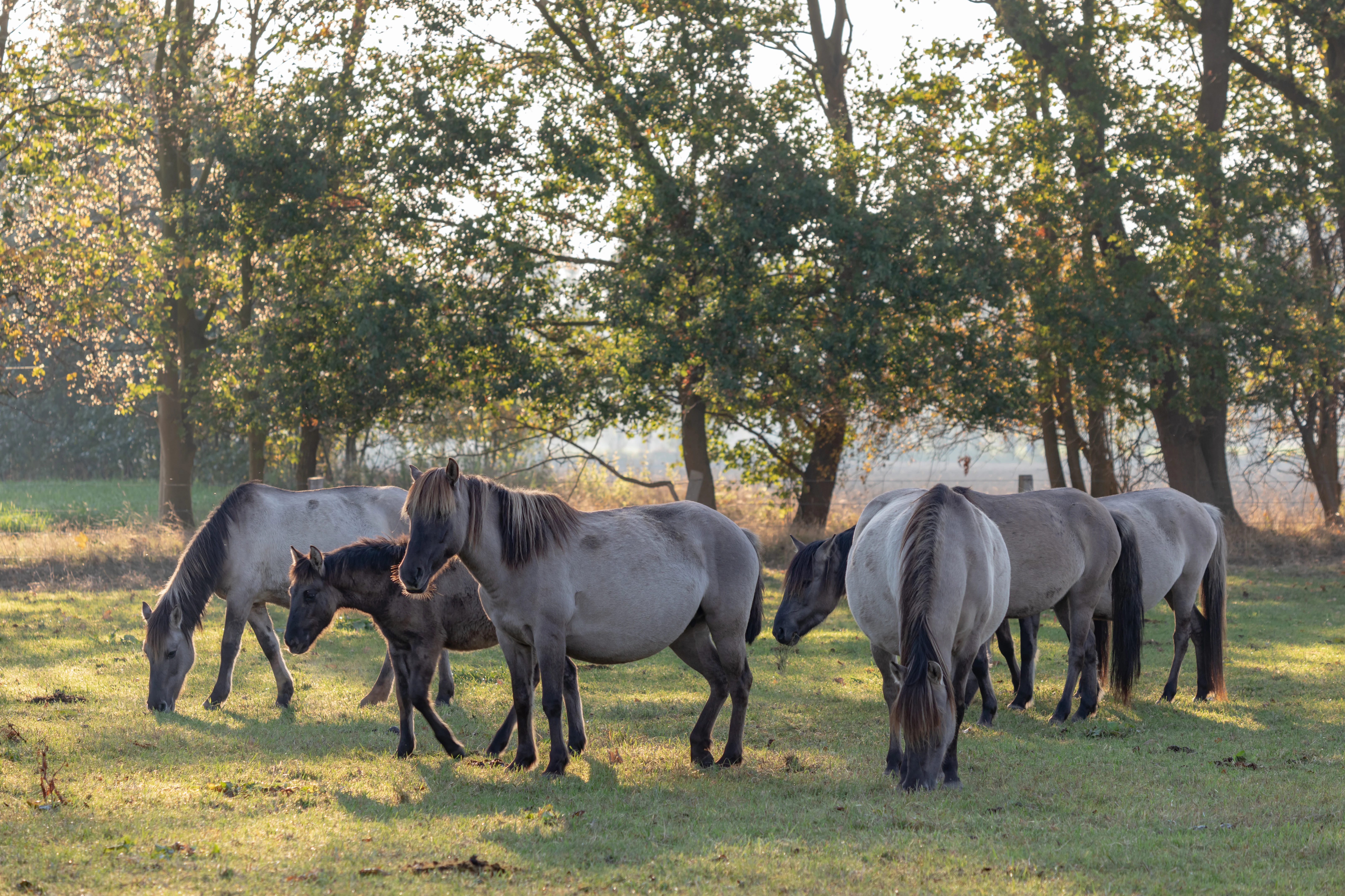
A group of light-colored horses with dark manes grazing in a meadow backed by a grove of trees.
A herd of Dülmen ponies grazing in the Merfelder Bruch nature reserve.

Wildpferdebahn im Merfelder Bruch history and protected-area timeline

The horse population that gives the Wildpferdebahn its identity was first documented in 1316, when the lord of Merfeld claimed rights over the wild horses of the area alongside fishing and hunting. At that time the Merfelder Bruch covered around 4,000 hectares of shared land whose use and management were divided between the local lord and the farmers of Merfeld.

By the early twentieth century, the Westphalian Wildbahnen, meaning traditional open ranges where horses lived without human control, were disappearing due to the division of common lands and the expansion of settlements. The Merfelder Bruch itself was partitioned between roughly 1840 and 1850, threatening the survival of its horse herd. In 1847, Duke Alfred of Croÿ acted to preserve the remaining animals, reportedly catching the last 40 horses and relocating them to a fenced portion of the Bruch, effectively creating the modern reserve. The name Wildpferdebahn derives from the older term Wildbahn, referring to the open wildlife range, and the area is also sometimes called the Wildpferdefangbahn because of its capture facilities.

Since that founding moment, the Dukes of Croÿ have continuously maintained the fence, the herd, and the management tradition that defines the reserve. The annual roundup of yearling stallions, the Wildpferdefang, has been documented since 1907 and remains a defining feature of the site's history. In 1956 a portion of the broader landscape extending east of Maria Veen and southwest of Merfeld was officially placed under nature protection, formalizing the site's conservation significance alongside its long-standing cultural role.

Wildpferdebahn im Merfelder Bruch landscape and geographic character

The Wildpferdebahn sits within the Merfelder Bruch, a tract of traditionally open, wet-influenced land in the Münsterland that originally covered several thousand hectares. Today the actively managed, fenced reserve occupies on the order of 500 hectares, while the more strictly regulated Naturschutzgebiet covers roughly 291 hectares. The terrain is gentle and low-lying, shaped less by dramatic relief than by contrasts between open and wooded land.

The landscape is a mosaic of pasture, moor remnants, dry heath, birch scrub, and denser woodland. Higher ground supports patches of mature high forest with conifer stands and oak-dominated sections, while lower and damper areas retain open moor and meadow vegetation. The mixture gives the reserve both abundant grazing and ample cover, allowing the horses to range freely across the full spectrum of habitat types while still finding shelter in wooded edges during bad weather.

This varied land cover is what allows the herd to live almost entirely off the landscape itself. Dry grassland, heath, and rough pasture supply forage; woodland edges and scrub provide protection from weather; and the open moor-influenced areas give the reserve its characteristic visual identity. The combination of these landscape elements is central to both the ecological interest of the site and the experience of walking or driving through the reserve.
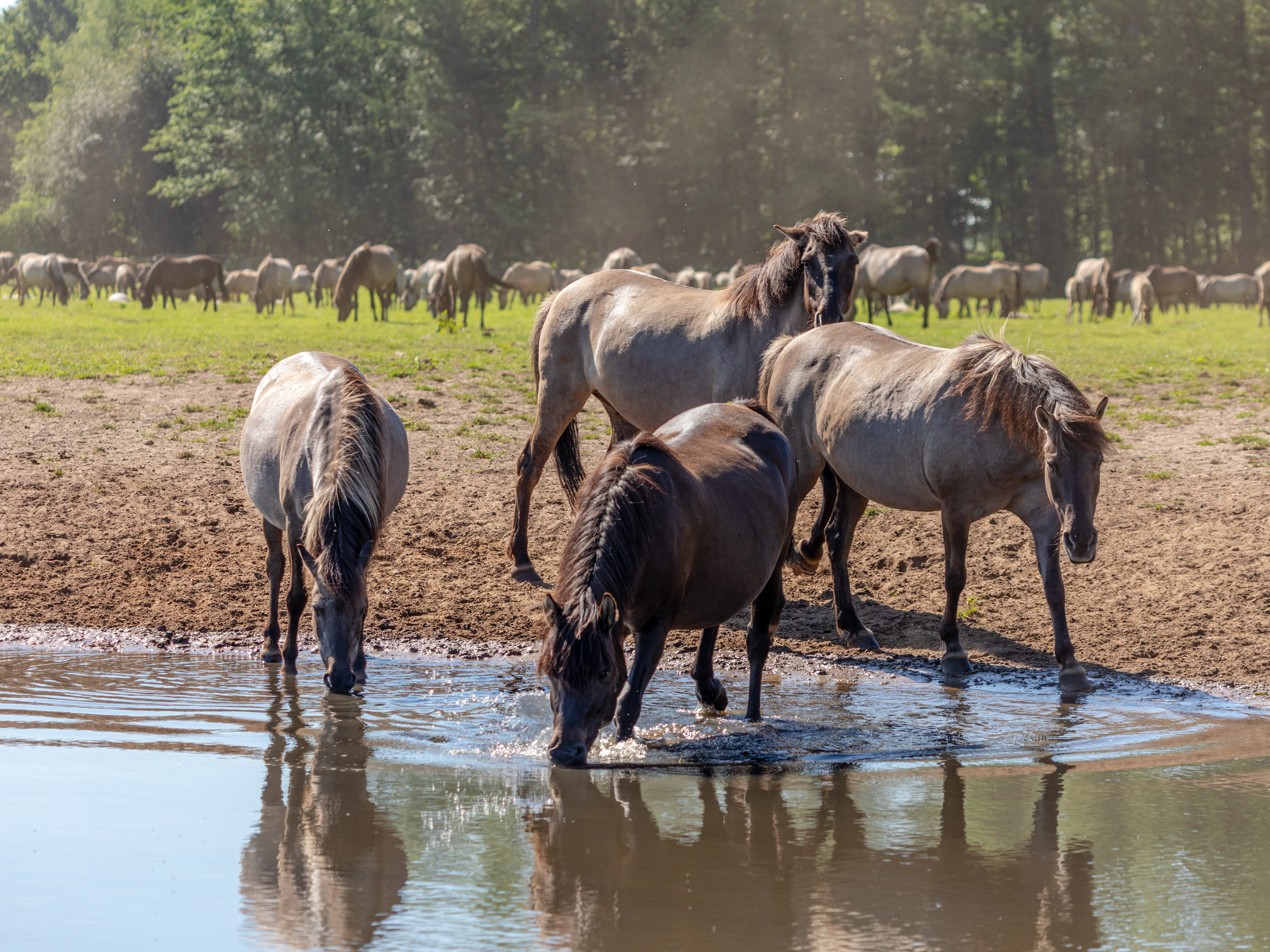
A group of Dülmen ponies, with three individuals in the foreground drinking from a shallow pool of water; a larger herd of horses grazes in the sunlit meadow in the background against a treeline.
A herd of Dülmen wild horses gathered at a waterhole in the Merfelder Bruch nature reserve.

Wildpferdebahn im Merfelder Bruch ecosystems, habitats, and plant life

Ecologically, the Merfelder Bruch is significant because it preserves a habitat mosaic that has become rare in the intensively farmed Münsterland. The reserve retains open and semi-open vegetation types maintained in part by the grazing of the horse herd, which suppresses woody encroachment and keeps dry grassland and heath in good condition. This grazing-driven landscape is explicitly cited as one of the values worth protecting in the reserve's official designation.

The woodland component of the reserve includes both coniferous high forest and stands of oak, together with areas of rare and threatened mature alder. The protection notice for the reserve highlights the preservation and support of near-natural broadleaf forest, and especially of these older alder populations. Heath and dry grassland communities shaped by the long presence of the horses form another ecological core of the site, and their preservation is closely tied to the continued presence of the herd.

The protected landscape also reflects its past as common grazing land. The legacy of centuries of low-intensity use, followed by formal protection in 1956, has produced a site where woodland, heath, open pasture, and moor remnants exist in close association. This ecological diversity within a relatively compact area is one of the defining reasons the reserve has both national park-style conservation value and cultural-historical importance.
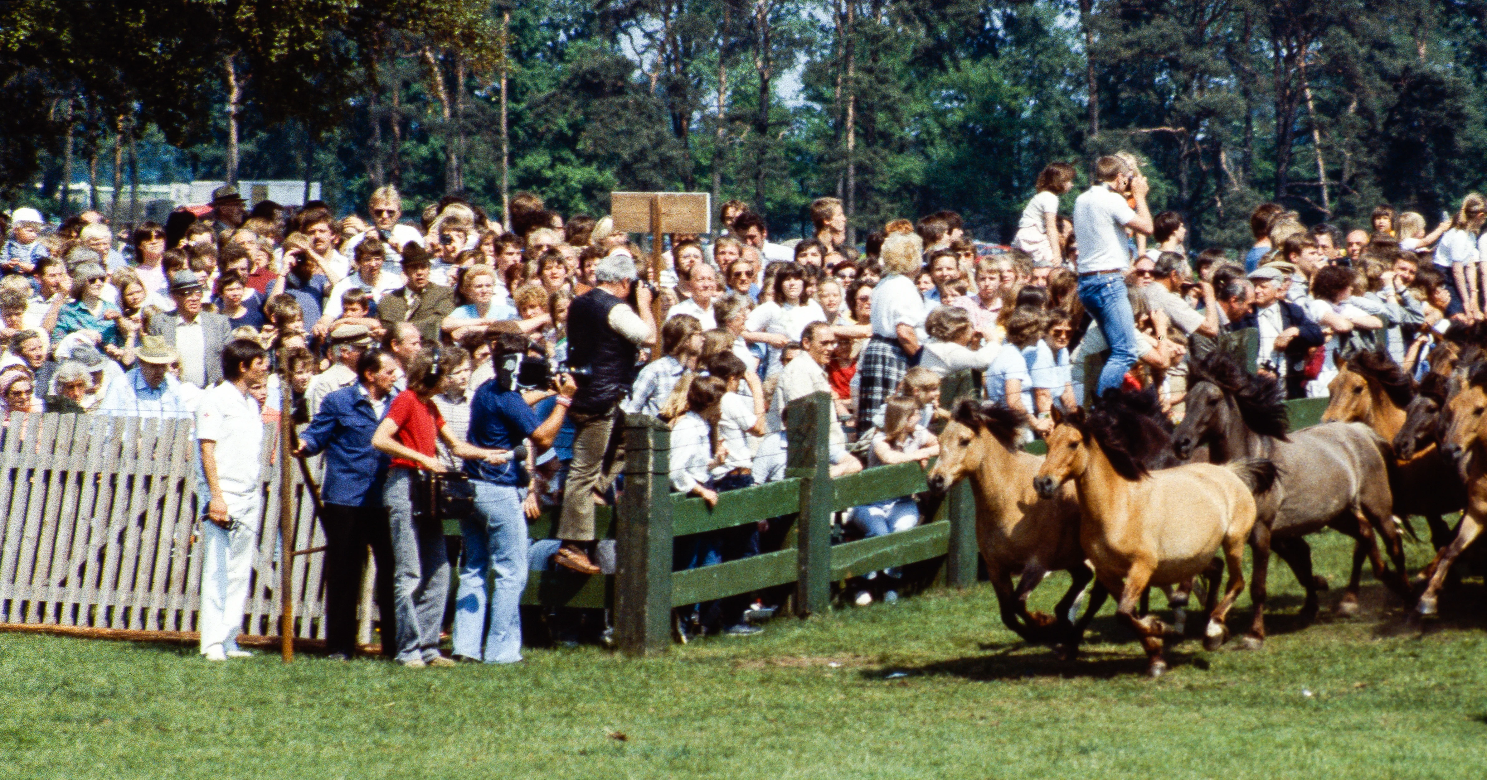
A crowd of spectators watches as several brown wild horses run past a wooden fence in a field, captured during an annual herd regulation event.
A historical photograph showing the annual wild horse capture at Merfelder Bruch in 1982.

Wildpferdebahn im Merfelder Bruch wildlife and species highlights

The dominant wildlife focus of the reserve is not a typical large mammal community but a single species population: the Dülmener Wildpferd. Live population figures vary somewhat across the reserve's management, but the herd inside the fenced area averages roughly 400 animals including foals, with figures of around 300 to 400 individuals commonly cited. Outside the roundup period the herd lives essentially free of human control, regulated by natural selection, climate, and food availability.

Yearling stallions removed in the annual Wildpferdefang are subsequently chipped, registered as Dülmener Wildpferde of the Duke of Croÿ, and placed through lottery and auction to private owners. Once removed from the reserve they are described as quickly losing their wariness of people and are widely regarded as calm, intelligent, and undemanding horses, popular as children's riding horses and as carriage horses. Within the reserve, however, the herd is otherwise left to manage itself, and only one stallion typically remains with the mares after the roundup.

The reserve's grassland, heath, and woodland mosaic also supports the wider fauna typical of Münsterland wet and dry habitats, although the source material focuses primarily on the horses as the central wildlife subject. It is this unusual concentration on a single iconic breed population, combined with its near-natural living conditions, that gives the site's wildlife character its distinctive profile.

Wildpferdebahn im Merfelder Bruch conservation status and protection priorities

The Wildpferdebahn has formal conservation status through its designation as a Naturschutzgebiet, established in 1956. Protection of the 291-hectare area between Maria Veen and Merfeld was specifically justified by the need to preserve pasture for the wild horses and their population, to maintain and promote near-natural broadleaf forest including rare and threatened mature alder, and to preserve and optimize the dry grassland communities that have developed under long-term grazing pressure.

Beyond this formal designation, the reserve's broader conservation significance lies in its function as a refuge for traditional Westphalian open-range grazing. Once a common practice across the region, the Wildbahn system of free-ranging horse herds on undivided common land has largely vanished from Central Europe, making the Merfelder Bruch both the last surviving example and a living experiment in maintaining grazing-driven habitat mosaics. The continued grazing of the horses is itself a conservation tool that shapes the heath and dry grassland communities the reserve was set up to protect.

Management combines minimal direct intervention with one critical annual action: the removal of yearling stallions during the Wildpferdefang, which is framed as a substitute for natural selection that would otherwise struggle to operate effectively in such a confined population. This approach, together with the absence of routine veterinary care and the requirement that animals survive the regional climate on their own, gives the reserve a conservation philosophy that emphasizes natural processes within carefully defined limits.

Wildpferdebahn im Merfelder Bruch cultural meaning and human context

The Wildpferdebahn is deeply embedded in the cultural heritage of Westphalia and the Münsterland. The historical Wildbahn, an open communal range used for grazing and other subsistence activities, shaped the regional landscape and the legal customs of shared land use for centuries, and documentation of the Merfeld horses goes back to 1316. By maintaining a working Wildbahn in the twenty-first century, the reserve preserves a cultural form that has effectively disappeared elsewhere in Central Europe.

The reserve's foundation as the Merfelder Bruch was being divided, and its survival through the foresight of Duke Alfred of Croÿ in 1847, ties it closely to the aristocratic land-management traditions of the region. Continuing ownership by the Dukes of Croÿ reinforces this connection. The annual roundup, the Wildpferdefang, originated in 1907 and has since become a major cultural event for the local community and a tourist attraction for visitors interested in traditional horse culture.

Beyond the roundup, the reserve's Dülmener horses carry regional identity beyond Merfeld. Animals sold at the auction are celebrated as representatives of a regional breed and are popular as family and working horses across Germany. The reserve is therefore not only a piece of natural heritage but also a living reminder of older relationships between people, horses, and the Westphalian countryside.

Top sights and standout views in Wildpferdebahn im Merfelder Bruch

The Wildpferdebahn's strongest highlights are concentrated in the combination of a still-functioning traditional Wildbahn with a population of several hundred Dülmener Wildpferde living in near-natural conditions, the reserve's status as the last surviving open horse range of its kind in Central Europe, the diversity of its habitat mosaic including pasture, moor, heath, birch scrub, and mixed woodland with rare mature alder, and the annual Wildpferdefang held on the last Saturday in May, which has been running since 1907 and remains culturally and ecologically central to the site.

Equally notable is the reserve's formal protection as a Naturschutzgebiet since 1956, which recognizes both the herd's habitat needs and the conservation value of its woodland and grassland communities. The continuity of private stewardship by the Dukes of Croÿ since 1847 gives the site an unusually stable and well-documented history, and the integration of long-running cultural tradition with modern nature protection makes the Wildpferdebahn a distinctive example of how a single protected area can hold both ecological and heritage significance at once.

Best time to visit Wildpferdebahn im Merfelder Bruch

The reserve is open to visitors on weekends and public holidays in North Rhine-Westphalia from around mid-March to early November between 10:00 and 18:00 in good weather, so the visiting season spans spring, summer, and much of autumn. The most distinctive time to plan a visit is late May, when the annual Wildpferdefang is held on the last Saturday of the month and the herd, the roundup, and the cultural atmosphere all converge in one event; tickets for that day are typically sold out months in advance.

Outside the roundup, late spring and early summer are good for seeing foals on the open pasture, while late summer and early autumn can offer calmer conditions and stable weather for observing the herd grazing across the full extent of the reserve. Winter brings a different atmosphere: the horses develop thick winter coats and remain outside, and visiting is generally not possible because the reserve is closed during that period.

Monthly climate preview

Measured temperature ranges and precipitation averages across twelve months

Wildpferdebahn Climate Normals and Long-Term Monthly Weather Patterns

Representative coordinate records show average monthly temperatures peaking in mid-year alongside consistent daily precipitation distribution throughout the annual cycle. Detailed monthly breakdowns provide deeper comparative metrics for long-term temperature ranges and precipitation normals across the terrain.
Annual mean10 °C
2 °C18 °C
Jan
Feb
Mar
Apr
May13°
Jun16°
Jul18°
Aug18°
Sep15°
Oct10°
Nov
Dec
Warmest month
July

18.4 °C

Coolest month
January

1.6 °C

Wettest month
December

2.5 mm/day

Driest month
April

1.5 mm/day

Park location guide

Geography guide, regional context, and park location map for Wildpferdebahn im Merfelder Bruch

Wildpferdebahn im Merfelder Bruch park geography, regions, and map view in Germany

Understand where Wildpferdebahn im Merfelder Bruch sits in Germany through a broader geographic reading of the surrounding landscape, nearby location context, and its mapped position within the national park landscape.

How Wildpferdebahn im Merfelder Bruch fits into Germany

Germany is a federal republic in Western and Central Europe with a population of over 83 million across sixteen constituent states. It is Europe's largest economy by nominal GDP and a major global exporter and importer. The capital is Berlin, and the country borders Denmark, Poland, Czech Republic, Austria, Switzerland, France, Luxembourg, Belgium, and the Netherlands.

Wider geography shaping Wildpferdebahn im Merfelder Bruch in Germany

Germany is located in Western and Central Europe, spanning 357,022 km². It borders Denmark to the north, Poland and the Czech Republic to the east, Austria and Switzerland to the south, and France, Luxembourg, Belgium, and the Netherlands to the west. The country has coastlines on the Baltic Sea and North Sea to the north, with the Alps located in the southern region.

Map view of Wildpferdebahn im Merfelder Bruch

Use this park location map to pinpoint Wildpferdebahn im Merfelder Bruch in Germany, understand its exact geographic position, and read its mapped placement within the surrounding landscape more clearly.

Pigeon | © OpenStreetMap contributors

Location context for Wildpferdebahn im Merfelder Bruch

Nordrhein-Westfalen

Explore photographic records of pasture, moor, heath, and the semi-feral Dülmener horse herd.

Wildpferdebahn Photos and Landscape Imagery: Visualising Central Europe's Last Wild Horse Reserve

Wildpferdebahn imagery documents the diverse habitat mosaic of the Merfelder Bruch, capturing open pastures, damp moorlands, birch scrub, and mixed woodlands where semi-feral horses roam freely. Visual documentation reveals the terrain and environmental conditions shaping this rare Central European nature reserve.

A group of light-colored horses with dark manes grazing in a meadow backed by a grove of trees.

A group of young light-colored Dülmen horses in the foreground standing on dry grass, with a larger herd grazing in the background against a line of green trees.

A group of Dülmen ponies, with three individuals in the foreground drinking from a shallow pool of water; a larger herd of horses grazes in the sunlit meadow in the background against a treeline.

A crowd of spectators watches as several brown wild horses run past a wooden fence in a field, captured during an annual herd regulation event.

Park atlas

Compare adjacent nature reserves and regional protected landscapes across the Münsterland

Exploring Other Parks Near Wildpferdebahn and Surrounding Protected Areas

Continuing beyond Wildpferdebahn leads to adjacent nature reserves and regional protected landscapes sharing similar lowland terrain. Comparing these surrounding habitats offers deeper perspective on Central European wildlife conservation and regional ecology.
Watercolor painting of a green wetland area with a stream, soft hills in the background, and sparse trees.
Nature reserveNordrhein-Westfalen
About 1.1 km away#1 closest

West

Heubachwiesen (BOR) Nature Reserve: Exploring the Heubach Stream Floodplain Geography

Wetland ecosystems and protected lowland terrain in western Münsterland.

This nature reserve in Nordrhein-Westfalen consists of four separate parcels characterized by flat wet meadows and shallow water features. As a protected area integrated into the EU Birds Directive, Heubachwiesen (BOR) serves as a vital refuge for threatened bird species and rare plant communities within the open, low-lying landscape of the Heubach floodplain.

Area
4.66 km²
Established
1982
IUCN
IV
Watercolor illustration of a pond in a moorland landscape with soft green hills and trees in the background.
Nature reserveNorth Rhine-Westphalia
About 9.8 km away#2 closest

North

Heidesee Nature Reserve: A Protected Heathland and Bog Mosaic in North Rhine-Westphalia

Geographic landscape mapping of the Coesfelder Heide

Heidesee preserves a compact, high-value ecosystem featuring acidic water, sphagnum moss cushions, and rare carnivorous plants. Located within the glacial-sandy terrain of the Coesfelder Heide, this nature reserve offers a look at preserved wetland habitats and regional biodiversity management in western Germany.

Area
0.052 km²
Established
1985
IUCN
IV
Access
Moderate access
A watercolor painting showing a soft, pastoral landscape with green rolling hills, distant pinkish-hued mountains, and small clusters of trees.
Nature reserveNordrhein-Westfalen
About 10 km away#3 closest

Northwest

Kuhlenvenn Nature Reserve: Geographic Insights and Wetland Protection in Germany

A vital bird refuge within the Münsterland landscape

Kuhlenvenn is a 67 hectare nature reserve situated in the western Münsterland. Originally formed through industrial sand extraction, this area now features a rich habitat mosaic of meadows, wet grasslands, and shallow pools. It serves as a key regional center for migratory and breeding bird species, demonstrating how restored landscapes provide essential refuge in the broader North Rhine-Westphalia geography.

Area
0.67 km²
Established
1988
IUCN
IV
Relief
Lowland
Watercolor painting of a tranquil pond at Kranenmeer, showing reflective water, distant tree lines, and foreground foliage hanging from the upper right corner.
Nature reserveNordrhein-Westfalen
About 13 km away#4 closest

Southwest

Kranenmeer Nature Reserve: Mapped Geography and Protected Wetland Boundaries

A preserved moorland enclave in the Westmünsterland region.

Kranenmeer preserves a fragile mosaic of open water, bog vegetation, and alder carr woodland in a compact site within Nordrhein-Westfalen. Study the mapped protected boundaries and subtle terrain transitions of this significant nature reserve that serves as a vital habitat for rare amphibians and specialized wetland species in the lowland northwest of Germany.

Area
1.4 km²
Established
1950
Relief
Lowland
Climate
Temperate
A watercolor painting showing a soft green rolling landscape, a winding stream in the foreground, and distant hills under a white background.
Protected landscapeGermany
About 19 km away#5 closest

Southwest

Naturpark Hohe Mark: Protected Landscape and Regional Geography Overview

Mapped terrain in North Rhine-Westphalia, Germany.

Gain insight into the complex topography of Naturpark Hohe Mark, an expansive protected area characterized by its transition from sandy upland forests to wetland-rich river valleys. This detailed overview covers the essential landscape features, regional boundaries, and ecological diversity that distinguish the park as a key geographical entity in Germany.

Area
1,978 km²
Established
1963
Relief
Mixed relief
Climate
Temperate
A pale, soft watercolor illustration showing rolling hills, sparse trees, and gentle inland dune slopes under a light sky.
Protected landscapeBerlin
About 22 km away#6 closest

East

Baumberge Protected Landscape: Mapping Berlin's Glacial Sand Dunes and Rare Grassland Habitats

A vital protected ecosystem within the Tegeler Forst region

The Baumberge stand as one of the last remaining open inland dune sites in Berlin, encompassing a fragile 47 hectare mosaic of sand heath and dry grassland. These parabolic dunes provide a critical refuge for warmth-loving invertebrate species and rare flora, anchored by glacial sand deposits dating back to the last ice age. The area offers a significant window into the historical landscape evolution of the northern Berlin glacial valley.

Area
0.47 km²
Relief
Lowland
Climate
Temperate
Access
Easy access
Nature reserveNorth Rhine-Westphalia
About 24 km away#7 closest

Southwest

Lichtenhagen Nature Reserve: Protected Lowland Landscapes and Habitat Geography in Wesel

A critical habitat mosaic for regional reptile and amphibian populations.

Lichtenhagen constitutes a distinct protected site within the Lower Rhine region, showcasing a unique ecological transition between heathland, still-water basins, and oak-dominated woodland. This former industrial site provides a protected refuge for the common European adder, smooth snake, and grass snake, representing a crucial case study in landscape restoration and regional conservation within North Rhine-Westphalia.

Area
1.1 km²
Established
1981
IUCN
IV
Nature reserveNetherlands
About 27 km away#8 closest

West

Wooldse Veen Nature Reserve: Mapped Geography and Protected Bog Landscapes in the Netherlands

A transboundary peatland system in Gelderland.

Wooldse Veen preserves a rare fragment of raised bog and peatland habitat in the Dutch-German borderlands. The reserve features restored bog pools, historic smugglers paths, and a mosaic of heathland and birch woodland that reflects the regional geography of the Winterswijk National Landscape.

Area
1.5 km²
Established
1949
Relief
Lowland
Climate
Temperate

Common questions about visiting, size, designation, and location context for Wildpferdebahn im Merfelder Bruch

Wildpferdebahn im Merfelder Bruch FAQs for park facts, access, geography, and protected area context

Find quick answers about Wildpferdebahn im Merfelder Bruch, including protected-area facts, park geography, trail and visitor context, and how the park fits into its surrounding country and regional landscape.
MoriAtlas Explorer

Continue Your Protected Areas Search Across the Global Atlas

Deepen your exploration by continuing the structured search for national parks and protected areas worldwide. Utilize the comprehensive filtering capabilities to compare different conservation landscapes and refine your understanding of global park geography. Discover more about the distribution and characteristics of protected natural areas.

Global natural geography