

Mori Atlas logo
Wildlife reserveRéserve de Wonga Wongué

Exploring the diverse lowland terrain, Ramsar wetlands, and Atlantic coastal geography

Réserve de Wonga Wongué: Mapped Coastal Wildlife Reserve and Protected Landscape in Gabon

Réserve de Wonga Wongué stands as a significant protected natural area along the Atlantic coast of Gabon, defined by its complex mosaic of lowland forests, dissected plateaus, and extensive wetland basins. This reserve encompasses a unique geographic profile where coastal lagoons and marshes support central African wildlife, including elephants and great apes, within a landscape that recently transitioned toward broader ecological research and conservation. The terrain, shaped by river systems flowing into the Atlantic, offers a profound look at one of the country's most expansive and historically protected coastal zones.

coastal reserveRamsar wetlandlowland foresttropical wetlandmangrove and marshpresidential reserve

Réserve de Wonga Wongué

Wildlife reserve

Park overview

Structured park overview, official facts, and landscape profile for Réserve de Wonga Wongué

Réserve de Wonga Wongué park facts, protected area profile, and essential visitor context

Review the core facts for Réserve de Wonga Wongué, including designation, size, terrain, visitor scale, habitats, and operating context in one park-focused overview.

About Réserve de Wonga Wongué

Réserve de Wonga Wongué occupies a significant stretch of Gabon's western coast and immediate hinterland, positioned between the Estuaire province to the north and Ogooué-Maritime province to the south, with the regional hub of Port-Gentil as the nearest major city. The protected area is unusually large for a coastal reserve, covering thousands of square kilometres of land that rises only modestly, from sea level to around two hundred metres in elevation. Its physical geography is defined by the meeting of forest, freshwater wetlands, and the Atlantic Ocean, producing a transitional environment where terrestrial and marine-influenced ecosystems overlap.

Historically, the reserve's trajectory has been unusual. It began as a fauna reserve, was converted into a national park, and then in 1972 was redesignated as a presidential reserve reserved for the use of the Gabonese head of state and their guests. This long closure effectively shielded the area from the kind of tourism and settlement pressures that affect many other African protected landscapes, and helped preserve populations of emblematic species including elephants, chimpanzees, gorillas, buffalo, and hippopotamus.

At the same time, the reserve has not been untouched. Even within its protected status, it has experienced poaching, particularly for elephant ivory, as well as illegal logging, hunting, and fishing. Its Ramsar designation in 1986 drew international attention to its wetland value, but wide public access remained off-limits for decades. The reserve's modern significance lies precisely in this tension: a biodiverse, internationally recognised wetland that has been ecologically preserved by restriction but is now being repositioned as a publicly accessible conservation and tourism asset.

Quick facts and research context for Réserve de Wonga Wongué

Réserve de Wonga Wongué spans roughly 4,281 square kilometres of coastal and inland terrain in western Gabon, between the Estuaire and Ogooué-Maritime provinces. It has been a Ramsar-listed wetland since 1986 and has operated since 1972 as a presidential reserve, closed to ordinary visitors for over fifty years. The landscape combines lowland plains, dissected plateaus, coastal swamps, and marshes fed by small coastal river systems, supporting both terrestrial mammals and marine-influenced birdlife.

Protection and recognition

Documented protected area designation and official Ramsar wetland status records

Réserve de Wonga Wongué Protection Status and International Recognition

Protected area records for Réserve de Wonga Wongué compile official designation data and international Ramsar wetland recognition sources. Structured database entries outline documented conservation frameworks and administrative recognition details for the reserve.
Park context

Deeper park guide and search-rich context for Réserve de Wonga Wongué

Réserve de Wonga Wongué history, landscape, wildlife, and travel context

Explore Réserve de Wonga Wongué through its history, landscape character, ecosystems, wildlife, conservation priorities, cultural context, and seasonal travel timing in a structured park guide built for atlas discovery and search intent.

Why Réserve de Wonga Wongué stands out

The reserve is best known for combining a large tract of Atlantic coastal and wetland habitat with a rich central African mammal fauna, all under an unusually restrictive long-term presidential protection regime. It is recognised for hosting elephants, chimpanzees, gorillas, buffalo, and hippopotamus in a lowland setting that also supports sea birds such as the white pelican along its lagoons and shoreline. Its Ramsar status adds a wetland dimension to what is otherwise often perceived simply as a private hunting reserve.

Réserve de Wonga Wongué history and protected-area timeline

The reserve originated as a fauna reserve in Gabon before being upgraded to national park status, reflecting early recognition of its exceptional mammal and wetland values. In 1972, however, its character changed markedly when it was reclassified as a presidential reserve dedicated to the use of the head of state of Gabon and invited guests, a designation that closed it to the general public for more than fifty years.

International recognition of its wetland importance came in 1986, when the site known under the Ramsar spelling Wongha-Wonghé was listed under the Ramsar Convention, placing it among Gabon's globally significant wetland areas. This designation underscored the ecological weight of its swamps, marshes, and coastal features, even as on-the-ground access remained tightly restricted.

The most recent chapter opened in 2024, when the transitional authorities of Gabon, under President Brice Oligui Nguema, announced the opening of the reserve to the public. Conservation stakeholders, including the site's conservator, welcomed the decision as an opportunity to develop scientific research, education, and sustainable tourism. By 2026, the reserve had been identified as one of the protected areas being showcased to international partners in support of stronger conservation investment.

Réserve de Wonga Wongué landscape and geographic character

The landscape of Wonga Wongué is shaped by its position along Gabon's Atlantic coast, where the land rises only gently from the shoreline. Altitudes range from sea level up to roughly two hundred metres, giving the reserve an overall lowland character. Within this broad coastal band, the terrain shifts between flat plains, low hills, and dissected plateaus cut through by numerous small coastal river systems.

Water defines much of the scenery. The hills and plateaus are drained by a network of short rivers flowing toward the Atlantic, and between them lie extensive swamps and marshes that mark the transition from dry land to sea. This mosaic of dryland ridges, river valleys, and wetland basins creates a varied coastal topography in which open water, reed beds, and forested ridges can lie close together.

Réserve de Wonga Wongué ecosystems, habitats, and plant life

The ecology of Wonga Wongué blends lowland coastal forest with extensive freshwater wetlands, producing a habitat mosaic that supports both forest-dependent mammals and species associated with water and shore. Small coastal rivers feed marshes and swamps that fringe the Atlantic coastline, and these wet zones grade back into more dissected terrain with plateaus and low hills supporting dense vegetation types typical of Gabon's western lowlands.

This convergence of forest and wetland gives the reserve an unusually broad habitat profile for a coastal site. Forested intervals provide refuge for great apes and large herbivores, while the swamps, marshes, and lagoons add a wetland component that links terrestrial fauna to migratory and resident waterbirds along the Atlantic flyway.

Réserve de Wonga Wongué wildlife and species highlights

The reserve is notable for retaining a mammal fauna typical of central African forests despite its coastal setting. Habitats here continue to support elephants, forest buffalo, hippopotamus, chimpanzees, and gorillas, a combination that illustrates the reserve's structural and ecological integrity rather than a single dominant species.

Alongside these mammals, the wetlands and coastal stretches host birdlife that includes sea birds and waterbirds, with the white pelican prominently cited among the reserve's characteristic species. Together, the mix of forest megafauna and water-associated avifauna gives Wonga Wongué a distinctive wildlife profile shared by very few other coastal protected areas in the region.

Réserve de Wonga Wongué conservation status and protection priorities

Conservations at Wonga Wongué has long depended on the site's exceptional legal status. From 1972 onward, its designation as a presidential reserve restricted human access to a small circle of state guests, a situation that produced decades of limited disturbance but also limited scientific study and public engagement. International recognition came through the 1986 Ramsar listing, which formally acknowledged the wetland values of the area.

Nonetheless, the reserve has not been immune to pressure. Poaching, particularly of elephants for ivory, has affected populations, and illegal logging, hunting, and fishing have all been documented within its boundaries. The opening of the reserve to the public announced in 2024 marked a turning point, framing the site not only as a refuge for wildlife but also as a platform for research, ecological tourism, and international conservation partnerships from 2026 onward.

Top sights and standout views in Réserve de Wonga Wongué

Réserve de Wonga Wongué stands out among Gabon's protected areas for the unusual combination of presidential-level protection, Ramsar-recognised wetlands, and central African megafauna along an Atlantic coastline. It is distinguished by the long shadow of its 1972 designation as a private reserve, which preserved species such as elephants, gorillas, chimpanzees, buffalo, and hippopotamus, while its marshes, lagoons, and coastal fringes secured it a place among internationally important wetlands.

Recent policy shifts have elevated its profile further, with the 2024 decision to open the reserve to the public, and by 2026 its inclusion among protected areas positioned for international partnership and investment. The result is a site that moves from being a closed enclave for heads of state to a new-generation destination for ecotourism, research, and conservation in Gabon.

Best time to visit Réserve de Wonga Wongué

Given the reserve's coastal position and lowland equatorial setting, climatic conditions are governed more by wet and dry phases than by traditional four-season calendars. The most favourable atmosphere for exploring marshes, plateaus, and small coastal rivers tends to align with seasonally drier windows, when tracks and visibility improve across plains and hills. Wet phases bring higher water levels in the swamps and marshes, enhancing wetland bird presence but also complicating movement across low-lying ground.
Monthly climate preview

Long term representative temperature and precipitation rhythms across the coordinate

Réserve de Wonga Wongué Climate Normals and Monthly Temperature Patterns

Representative coordinate records show mean monthly temperatures ranging from 23.75 to 26.58 degrees Celsius alongside marked shifts in daily precipitation levels throughout the annual cycle. Reviewing the complete twelve month data profile provides detailed numerical context for long term temperature and moisture patterns at this protected location.
Annual mean25 °C
24 °C27 °C
Jan26°
Feb26°
Mar27°
Apr26°
May26°
Jun25°
Jul24°
Aug24°
Sep25°
Oct25°
Nov26°
Dec26°
Warmest month
March

26.6 °C

Coolest month
July

23.8 °C

Wettest month
November

11.6 mm/day

Driest month
July

0.2 mm/day

Park location guide

Geography guide, regional context, and park location map for Réserve de Wonga Wongué

Réserve de Wonga Wongué park geography, regions, and map view in Gabon

Understand where Réserve de Wonga Wongué sits in Gabon through a broader geographic reading of the surrounding landscape, nearby location context, and its mapped position within the national park landscape.

How Réserve de Wonga Wongué fits into Gabon

Gabon is a Central African country on the Atlantic coast, positioned on the equator. It gained independence from France in 1960 and is governed as a unitary presidential republic. The country has significant oil wealth and one of the highest Human Development Index rankings in Africa, though wealth distribution remains uneven.

Wider geography shaping Réserve de Wonga Wongué in Gabon

Gabon is situated on the Atlantic coast of Central Africa, positioned along the equator. It borders Equatorial Guinea to the northwest, Cameroon to the north, and the Republic of the Congo to the east and south. The terrain includes coastal plains along the Atlantic, mountain ranges in the center (the Cristal Mountains and Chaillu Massif), and savanna zones in the east.

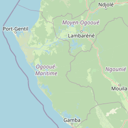
Map view of Réserve de Wonga Wongué

Use this park location map to pinpoint Réserve de Wonga Wongué in Gabon, understand its exact geographic position, and read its mapped placement within the surrounding landscape more clearly.

Pigeon | © OpenStreetMap contributors

Location context for Réserve de Wonga Wongué

EstuaireOgooué-Maritime
Park atlas

Compare adjacent coastal lowland reserves and regional wetland habitats

Explore Protected Areas and Parks Near Réserve de Wonga Wongué in Gabon

Browsing other protected natural areas near Réserve de Wonga Wongué reveals broader ecological patterns across the Atlantic coastal zone and surrounding river basins. Expanding the geographic comparison highlights similar lowland forests, tropical wetlands, and conservation landscapes throughout the region.
National parkGabon
22 km away#1 closest

North

Pongara National Park: Protected Landscape and Geographic Exploration in Gabon

Mapped boundaries and regional natural context.

Pongara National Park is a designated national park within Gabon, offering a unique opportunity for structured exploration of protected lands. Users can investigate its specific geographic setting, understand its mapped boundaries, and appreciate its place within the regional landscape context. This entry provides a factual foundation for understanding the park's identity as a protected natural area and its contribution to Gabon's geography.

Area
929 km²
Established
2002
IUCN
II
Relief
Lowland
National parkGabon
71 km away#2 closest

North

Akanda National Park: A Key Protected Landscape on Gabon's Atlantic Coast

Explore Gabon's vital mangrove ecosystems and coastal protected areas.

Akanda National Park in Gabon is a significant protected area celebrated for its expansive mangrove forests and critical role in supporting migratory bird populations. Located along the Atlantic coast, this park's unique landscape at the nexus of tidal waters and coastal terrain makes it a valuable site for understanding regional ecology and mapped protected lands. It serves as a primary destination for exploring the natural geography and conservation significance of West African coastal environments.

Area
540 km²
Established
2002
IUCN
II
Relief
Lowland
National parkWoleu-Ntem Province
93 km away#3 closest

Northeast

Crystal Mountains National Park: National Park Protected Area and Geographic Context in Woleu-Ntem Province

Explore its mapped boundaries and regional landscape.

Crystal Mountains National Park is a designated national park offering critical insights into its protected landscape and geographic setting. Users can explore the mapped boundaries of this protected area, understand its regional terrain, and gain context within Woleu-Ntem Province through structured geographic data. This page provides the foundational atlas information for comprehending the park's conservation significance and natural features.

Area
1,200 km²
Established
2002
IUCN
II
Relief
Mountain
National parkGabon
109 km away#4 closest

South

Loango National Park: Gabon's Coastal Wilderness and Unique Protected Landscape

Explore savanna, forest, beach, and lagoon ecosystems in this vital national park.

Loango National Park in Gabon is a significant protected area recognized for its remarkable geographic diversity. This national park encompasses over 100 kilometers of pristine, uninhabited Atlantic coastline, rare mangrove systems, and expansive savanna plains transitioning into dense tropical forests. Its unique landscape, particularly the Iguéla Lagoon, offers rich opportunities for atlas-style exploration of coastal ecosystems and protected areas. Understanding the park's mapped boundaries and regional setting is key to appreciating its ecological importance.

Area
1,550 km²
Established
2002
IUCN
II
Relief
Lowland
National parkGabon
125 km away#5 closest

Southeast

Waka National Park: A Mapped Protected Landscape in Gabon's Geography

Explore the natural terrain and park boundaries of this national park.

Waka National Park in Gabon represents a vital protected landscape for geographic exploration. This dedicated detail page offers insight into the park's specific mapped area and its place within the country's broader natural terrain. Understand its context as a national park, contributing to the atlas of protected areas in Central Africa. Discover the geographic identity of this significant natural reserve.

Area
1,060 km²
Established
2002
IUCN
II
Relief
Mountain
Watercolor painting of a landscape with grassy areas, a lake, and distant hills under a light sky
National parkGabon
140 km away#6 closest

East

Lopé National Park: Gabon's Protected Landscape and National Park Geography

Explore mapped boundaries and natural terrain in Central Africa.

Delve into Lopé National Park, a designated national park situated in Gabon. This protected area serves as a crucial point for understanding the nation's geography and the distribution of its conservation landscapes. As an entry in the MoriAtlas, it offers a detailed view of its mapped territory and its contribution to the broader regional context of Central Africa, emphasizing its role in protected area atlas exploration.

Area
4,910 km²
Established
2002
IUCN
II
Relief
Mixed relief
Wildlife reserveOgooué-Maritime
About 164 km away#7 closest

South

Zone humide de Petit Loango Wildlife Reserve: Regional Atlas and Protected Area Context

Extensive coastal wetland complex in Ogooué-Maritime, Gabon

Examine the geographic boundaries and landscape composition of Zone humide de Petit Loango. This Ramsar-recognized site in Ogooué-Maritime encompasses the Petit Loango Fauna Reserve alongside associated hunting domains, creating a unique coastal environment defined by dense mangrove networks, river estuaries, and inland freshwater swamps.

Area
4,800 km²
Established
1986
Relief
Lowland
Scope
Mixed
National parkGabon
About 200 km away#8 closest

Southeast

Moukalaba-Doudou National Park: Protected Forest and Savanna Mosaic in Southeastern Gabon

Geographic overview of a key Central African protected area.

Moukalaba-Doudou National Park represents a significant protected area in southeastern Gabon, covering 4,500 square kilometers of diverse terrain. The park is defined by its unusual interaction between humid tropical rainforest and expansive savanna grasslands, marking it as a critical ecological transition zone in the Congo Basin region.

Area
4,500 km²
IUCN
II
Scope
Terrestrial
Water
Minor water

Common questions about visiting, size, designation, and location context for Réserve de Wonga Wongué

Réserve de Wonga Wongué FAQs for park facts, access, geography, and protected area context

Find quick answers about Réserve de Wonga Wongué, including protected-area facts, park geography, trail and visitor context, and how the park fits into its surrounding country and regional landscape.
MoriAtlas Explorer

Continue Your Protected Areas Search Across the Global Atlas

Deepen your exploration by continuing the structured search for national parks and protected areas worldwide. Utilize the comprehensive filtering capabilities to compare different conservation landscapes and refine your understanding of global park geography. Discover more about the distribution and characteristics of protected natural areas.

Global natural geography