
Mori Atlas logo
Nature reserveWulmstorfer Heide mit Bornberg

Mapping the protected heathland and forest mosaic at the Hamburg state border in Landkreis Harburg

Wulmstorfer Heide mit Bornberg Nature Reserve: A Detailed Geographic and Landscape Atlas Profile

(Naturschutzgebiet "Wulmstorfer Heide mit Bornberg" (NSG LÜ 379))

Wulmstorfer Heide mit Bornberg represents a 272-hectare nature reserve defined by its striking transition between sandy heathland, moist moor forests, and old-growth deciduous stands. Positioned in the northern Harburger Berge, this protected area preserves a unique mosaic of habitats that were shaped by both glacial topography and a twentieth-century military history. The site serves as a vital component of a cross-border biotope network, offering a window into the varied microtopography and ecological corridors of northern Lower Saxony.

heathlanddwarf-shrub heathheathermoor forestdeciduous forestwetland
A flat-style digital illustration showing a waterfall cascading over rocky cliffs into a winding river that flows through a landscape of birch trees, pine trees, and heathland under a sunlit sky.

Wulmstorfer Heide mit Bornberg

Nature reserve

Park overview

Structured park overview, official facts, and landscape profile for Wulmstorfer Heide mit Bornberg

Wulmstorfer Heide mit Bornberg park facts, protected area profile, and essential visitor context

Review the core facts for Wulmstorfer Heide mit Bornberg, including designation, size, terrain, visitor scale, habitats, and operating context in one park-focused overview.

About Wulmstorfer Heide mit Bornberg

Wulmstorfer Heide mit Bornberg is a nature reserve of moderate size and considerable ecological interest in the northwestern Harburg district, on the very edge of the Hamburg conurbation. Although only formally designated as a Naturschutzgebiet in 2024, the character of the land has been shaped for decades by its previous use as a Standortübungsplatz; the absence of intensive agricultural conversion, combined with deliberate disturbance of the surface, has produced a landscape that today resembles a semi-natural North German heath and woodland mosaic.

The reserve sits on the northern fringe of the Harburger Berge, where the rolling glacial terrain of the Geest drops down toward the broad Elbe Urstromtal. This position gives the area a distinct landscape gradient: higher, drier sandy ridges support heather, dry grassland, and relict oak or oak-birch woodland, while lower, flatter ground holds wet heath and moor forest. Around the Bornberg, a prominent hill inside the area, viewpoints open up toward the preserved tank ring road from the military era.

The reserve connects directly to the Hamburg Fischbeker Heide along its eastern edge, and together the two areas form one of the larger contiguous open-land complexes in this part of the Hamburg Metropolitan Region. On its southeastern side, the protected area abuts the larger landscape protection area Rosengarten and Kiekeberg and Stuvenwald, extending a network of protected open and semi-open habitats across the state boundary. The result is a reserve whose significance extends well beyond its official boundary.

Wulmstorfer Heide mit Bornberg is also an example of modern nature reserve management in Lower Saxony. Dry heath is maintained by grazing and active scrub control, conifer stands from past afforestation are being converted into near-natural broadleaf and mixed woodland, and selected, less ecologically valuable forest areas have been cleared to allow new heath surfaces to develop. A network of paths, including a preserved Panzerringstraße from the military era, makes much of the area accessible on foot for quiet recreation and nature observation.

Quick facts and research context for Wulmstorfer Heide mit Bornberg

Wulmstorfer Heide mit Bornberg is a Lower Saxon nature reserve of about 272 hectares, established on 1 July 2024 under the designation NSG LÜ 379. It is located in Neu Wulmstorf, Landkreis Harburg, directly at the border with Hamburg. The reserve covers much of a former military training area (Standortübungsplatz) in the northern Harburger Berge and reaches from about 23 metres up to about 83 metres in elevation. IUCN category IV applies, indicating a habitat and species management area, and the responsible authority is the NLWKN, with the Landkreis Harburg acting as the lower nature conservation authority.

Protection and recognition

Review documented terrestrial protection scope and international recognition records

Wulmstorfer Heide mit Bornberg Protection Status and Area Recognition

Wulmstorfer Heide mit Bornberg features a documented terrestrial protection scope without imported international recognition sources. Reviewing these verified administrative records clarifies the official conservation status and management framework governing the territory.

Protection details

Protection scope
Terrestrial
Transboundary protection
No
Park context

Deeper park guide and search-rich context for Wulmstorfer Heide mit Bornberg

Wulmstorfer Heide mit Bornberg history, landscape, wildlife, and travel context

Explore Wulmstorfer Heide mit Bornberg through its history, landscape character, ecosystems, wildlife, conservation priorities, cultural context, and seasonal travel timing in a structured park guide built for atlas discovery and search intent.

Why Wulmstorfer Heide mit Bornberg stands out

The reserve is best known for its heather-dominated open landscape, which has developed on the sandy, sun-exposed soils of a former military training ground, and for the unusually rich mixture of dry heath, near-natural broadleaf forest, and wet biotopes within a compact 272-hectare area. It is also recognized for its role as part of a cross-border biotope network with the Hamburg Fischbeker Heide and for its value as habitat for reptiles, amphibians, and heathland birds that have become rare elsewhere in the intensively used landscape of the Hamburg metropolitan region.
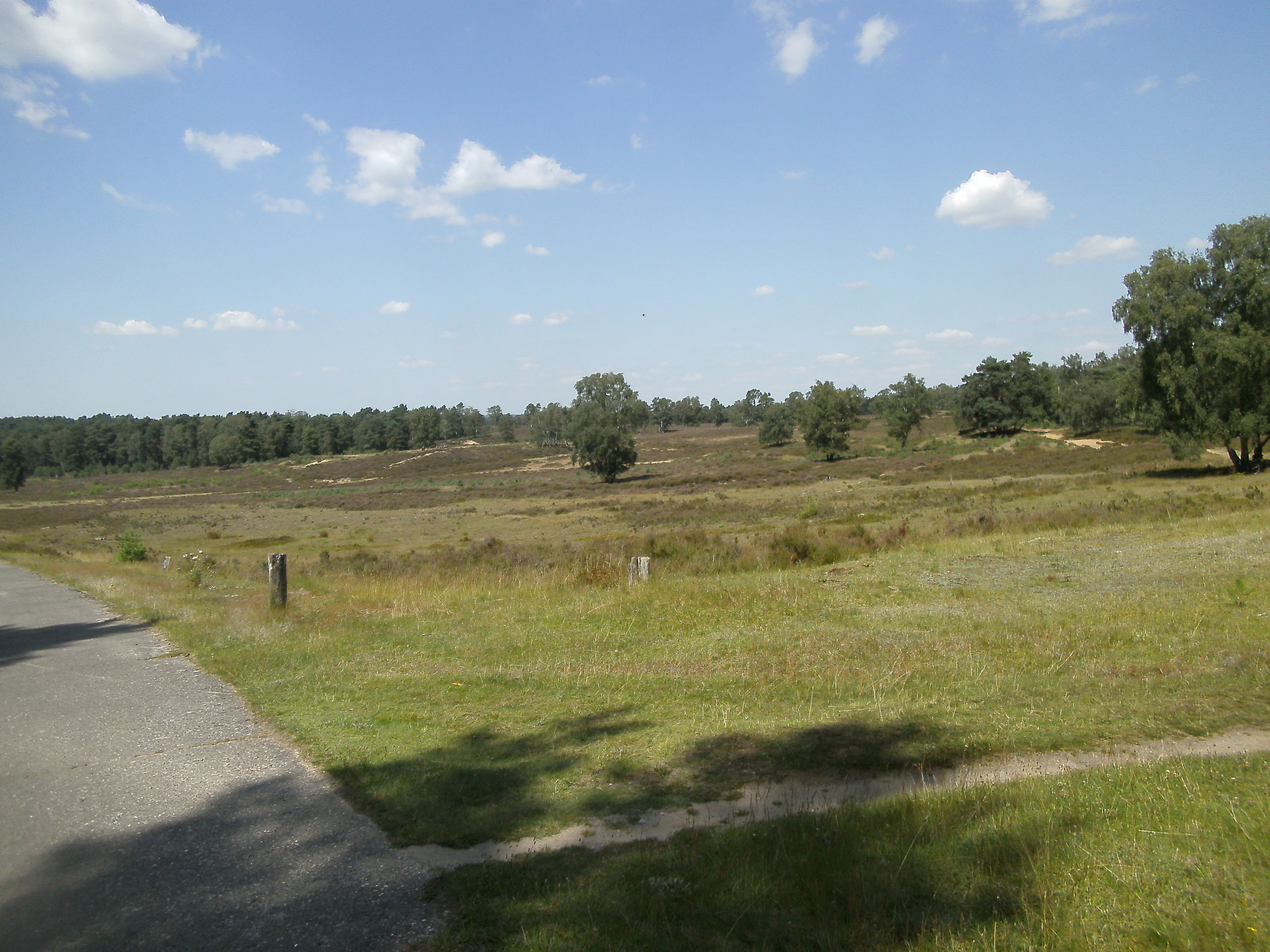
A wide angle view of an open, grassy heathland landscape under a blue sky with scattered clouds, with a paved road visible in the bottom left corner.
A view across the open heathland of Wulmstorfer Heide in the Harburger Berge area.

Wulmstorfer Heide mit Bornberg history and protected-area timeline

The contemporary nature reserve is very young: Wulmstorfer Heide mit Bornberg was formally placed under protection by the Landkreis Harburg on 1 July 2024, under the identifier NSG LÜ 379. Its legal status as a Naturschutzgebiet follows the standard German framework, with the NLWKN acting as the responsible higher authority and the district acting as the lower nature conservation authority.

The landscape itself, however, is much older than its designation. For decades before protection, the core of the present reserve was used as a Standortübungsplatz, a military training ground. This long period of restricted civilian use prevented the area from being converted to intensive agriculture or forestry, while the repeated mechanical disturbance of vehicles and foot traffic produced the bare, sandy, open conditions that heathland species depend on. The visible traces of this era, including a preserved Panzerringstraße, are now part of the reserve's cultural and recreational character.

The protection of the area must also be understood in the context of a broader regional effort. The reserve borders the Hamburg Fischbeker Heide, a long-established protected area on the other side of the state line, and is connected through that adjacency to decades of cross-border cooperation on heath conservation in the Hamburg-Harburg transition zone. Both the relatively recent designation date and the active management measures, including conifer removal and heath expansion, reflect the standard Lower Saxon approach of restoring formerly open, formerly military landscapes into resilient habitat complexes.

Wulmstorfer Heide mit Bornberg landscape and geographic character

Wulmstorfer Heide mit Bornberg lies in the northern Harburger Berge, a low ridge of glacial sandy terrain that rises gently above the flat Elbe Urstromtal to the north. The reserve's elevation range runs from about 23 metres in its lower edges up to roughly 83 metres around the Bornberg, the local high point that gives the protected area half of its name. From the Bornberg, panoramas open across the surrounding forest and heath, and on clear days the underlying Elbe lowland becomes visible beyond the woodland.

The terrain inside the reserve is shaped by its glacial origin and its military past. Old vehicle tracks and tank paths cut through the sandy soil, and the preserved Panzerringstraße forms a striking linear feature across the landscape, now softened by encroaching vegetation but still clearly readable as a piece of twentieth century history. Slight depressions and level stretches alternate with low ridges, producing a small-scale mosaic of dry and slightly moister conditions within a relatively compact area.

To the west and south, the broader Harburger Berge continue as forested countryside; to the northeast, the protected area steps down toward the open Elbe lowland. This transitional position between higher Geest and the flat marshland gives the reserve a varied microtopography despite its modest size and explains why such a wide range of dry, mesic, and wet habitats can exist within a single 272-hectare footprint.

Wulmstorfer Heide mit Bornberg ecosystems, habitats, and plant life

The nature reserve protects a particularly rich heath and woodland mosaic for its size. Open areas are dominated by low-growing Zwergstrauchheide, or dwarf-shrub heath, built from common heather (Besenheide), bell heather (Glockenheide), bilberry and lingonberry. Between the heath patches are areas of Magerrasen, or nutrient-poor grassland, and Borstgrasrasen, mat-grass swards typical of acid sandy soils that have escaped fertilisation. Together these open and semi-open habitats make up the reserve's character-defining layer.

The woodland areas are near-natural deciduous forests, locally with a notably high share of old trees and standing or fallen dead wood. There are old oak stands and old beech stands, both of which are increasingly rare in the intensively used surrounding landscape. Some forested sections originated as 20th century conifer plantations on former heath, and these are now being converted by active management into more natural broadleaf and mixed woodland, gradually restoring the originally intended forest character of the higher ground.

Wet habitats are an equally important part of the reserve's ecological identity. Feuchtbiotope, including Feuchtheide and Moorwald, or moor forests, occupy the flatter and lower parts of the area. These wet zones are biologically distinct from the dry heath and host different plant communities and animal groups, while also serving as ecological bridges between the dry plateau and the Elbe lowland. The combination of dry heath, deciduous forest, and wet peat-edge habitats within a single protected area is one of the reserve's strongest ecological features.

Wulmstorfer Heide mit Bornberg wildlife and species highlights

The combination of dry heath, rank vegetation, dead wood, and wet hollows makes the reserve valuable for reptile species that have become scarce in much of western Lower Saxony. The area holds the adder, the smooth snake, the slow worm, the sand lizard, and the forest lizard, all of which depend on warm, structurally varied open ground. The presence of the adder and the smooth snake in particular gives the reserve regional significance for reptile conservation.

Amphibians are well represented in the wetter zones. Common toad, natterjack toad, common frog, moor frog, and smooth newt all occur, taking advantage of the standing water and moist heath transitions. The natterjack toad is notable as a species with strong affinities to open sandy habitats, and its presence underlines the continuing ecological value of the former training ground environment.

The open heath and woodland edge provide habitat for breeding birds typical of these transitional landscapes, including the woodlark and the tree pipit. The wooded parts host a range of woodpeckers and bats, both groups that benefit from the reserve's emphasis on old trees and dead wood. Among invertebrates, the heath grasshopper is characteristic of the dry heather, while the sandy soils support distinctive communities of ground beetles and sand wasps, small but ecologically meaningful indicators of habitat quality. The amphibians are protected across all four of the frog species mentioned.

Wulmstorfer Heide mit Bornberg conservation status and protection priorities

Wulmstorfer Heide mit Bornberg plays an important role in the regional conservation of open and semi-open landscapes that have been heavily reduced by agriculture, forestry, and urbanisation across the Hamburg Metropolitan Region. The reserve functions as a habitat protection area under IUCN Category IV, with explicit management goals rather than purely passive protection. Its conservation value rests on the combination of dry heath, old broadleaf woodland, and wet biotopes within a relatively small but ecologically coherent footprint.

The reserve's significance is greatly increased by its position at the Hamburg state boundary. It adjoins the Hamburg Fischbeker Heide, and together the two areas form a cross-border biotope network (Biotopverbund) that maintains habitat continuity across an intensively used metropolitan edge. This link is strategically important because many heathland species depend on sufficiently large, connected open-land complexes to sustain viable populations. The reserve is also flanked to the southeast by the larger Rosengarten landscape protection area, embedding it in a multi-tier system of protected open countryside.

Management combines traditional heath care with active restoration. Heath is maintained by grazing and repeated removal of invasive shrubs, while conifer stands from past afforestation are being converted into near-natural broadleaf forests. Some less ecologically valuable woodland edges have been deliberately cleared to allow new open-heath surfaces to develop. In this way the reserve functions as both a refuge for existing heath and woodland biodiversity and as an active restoration project rebuilding habitat that had been simplified by 20th century land use.

Wulmstorfer Heide mit Bornberg cultural meaning and human context

Although Wulmstorfer Heide mit Bornberg is primarily an ecological site, its recent history is inseparably linked to military use. For decades, the area was a Standortübungsplatz, and the visible infrastructure of that period, above all the preserved Panzerringstraße, has become a defining cultural and recreational feature of the landscape. The tank ring road now serves hikers and nature observers rather than vehicles, marking a quiet but significant shift in the area's meaning from a training ground to a place of nature experience.

The reserve also sits within a wider regional identity shaped by the Lüneburg Heath and the broader Lower Saxon tradition of heath preservation. Protecting large stretches of dry heath against reforestation and agricultural intensification is part of the long-established cultural and conservation narrative of northern Germany, and Wulmstorfer Heide mit Bornberg is a small but meaningful continuation of that tradition in the densely populated Hamburg-Harburg transition zone.

Top sights and standout views in Wulmstorfer Heide mit Bornberg

Wulmstorfer Heide mit Bornberg stands out for the unusually complete heath, woodland, and wetland mosaic packed into a 272-hectare reserve directly on the Hamburg border. Its former use as a military training area produced the open sandy conditions that today support reptiles like the adder and the smooth snake, plus heath-breeding birds such as the woodlark and the tree pipit, all in a metropolitan context where such species are otherwise scarce. The reserve's combination with the adjacent Hamburg Fischbeker Heide, its dead-wood-rich old oak and beech stands, and active restoration of conifer plantations give it a conservation profile uncommon for a nature reserve only formally designated in 2024.

Best time to visit Wulmstorfer Heide mit Bornberg

The reserve is an open landscape of heather, woodland edge, and wet hollows, and the character of a visit shifts with the seasons. Late summer and early autumn are generally the most expressive time to experience the area, when heather comes into flower and the open heath surfaces become visually dominant; spring can be rewarding for bird song along the woodland edge, while winter and early spring offer clearer views through the deciduous woodland toward the Bornberg. Because the reserve is a working nature protection area, visitors should plan walks along the established paths, including the preserved tank ring road from the military era.

Monthly climate preview

Long-term representative monthly temperature and precipitation patterns across the protected landscape

Wulmstorfer Heide mit Bornberg Climate Normals and Annual Temperature Rhythm

Representative coordinates record mean monthly temperatures from 0.53 degrees Celsius to 17.99 degrees Celsius alongside daily precipitation rates between 1.41 mm and 2.56 mm. Examining the complete twelve-month record reveals detailed baseline fluctuations across the protected area.
Annual mean9 °C
1 °C18 °C
Jan
Feb
Mar
Apr
May13°
Jun16°
Jul18°
Aug18°
Sep14°
Oct
Nov
Dec
Warmest month
July

18 °C

Coolest month
January

0.5 °C

Wettest month
July

2.6 mm/day

Driest month
April

1.4 mm/day

Park location guide

Geography guide, regional context, and park location map for Wulmstorfer Heide mit Bornberg

Wulmstorfer Heide mit Bornberg park geography, regions, and map view in Germany

Understand where Wulmstorfer Heide mit Bornberg sits in Germany through a broader geographic reading of the surrounding landscape, nearby location context, and its mapped position within the national park landscape.

How Wulmstorfer Heide mit Bornberg fits into Germany

Germany is a federal republic in Western and Central Europe with a population of over 83 million across sixteen constituent states. It is Europe's largest economy by nominal GDP and a major global exporter and importer. The capital is Berlin, and the country borders Denmark, Poland, Czech Republic, Austria, Switzerland, France, Luxembourg, Belgium, and the Netherlands.

Wider geography shaping Wulmstorfer Heide mit Bornberg in Germany

Germany is located in Western and Central Europe, spanning 357,022 km². It borders Denmark to the north, Poland and the Czech Republic to the east, Austria and Switzerland to the south, and France, Luxembourg, Belgium, and the Netherlands to the west. The country has coastlines on the Baltic Sea and North Sea to the north, with the Alps located in the southern region.

Map view of Wulmstorfer Heide mit Bornberg

Use this park location map to pinpoint Wulmstorfer Heide mit Bornberg in Germany, understand its exact geographic position, and read its mapped placement within the surrounding landscape more clearly.

Pigeon | © OpenStreetMap contributors

Location context for Wulmstorfer Heide mit Bornberg

Landkreis HarburgNiedersachsen
Recorded earthquake history

Examine Recorded Earthquake History Near Wulmstorfer Heide mit Bornberg

Explore a historical catalogue of recorded seismic events associated with the location of the Wulmstorfer Heide mit Bornberg nature reserve. MoriAtlas provides these records to support geographic research and understanding of seismic history within this specific protected area of the Harburg district.

Wulmstorfer Heide mit Bornberg Earthquake History

Catalogued events

1 event

Strongest magnitude

Magnitude 3.8

Most recent event

Jun 2, 1977

This history includes earthquakes recorded inside the park or within 50 km of its borders

Explore photographic records of dry heath, broadleaf woodland, and glacial terrain within the reserve.

Wulmstorfer Heide mit Bornberg Photos and Landscapes: Visualizing the Protected Area Scenery

Visual documentation of Wulmstorfer Heide mit Bornberg reveals the complex mosaic of open heather biotopes, sandy ridges, and wet moor forests defining the protected landscape. Examining high-resolution habitat photography provides deeper insight into the ecological character and varied topography of the Harburger Berge reserve.

A wide angle view of an open, grassy heathland landscape under a blue sky with scattered clouds, with a paved road visible in the bottom left corner.

Park atlas

Compare surrounding regional reserves and connected northern German habitats

Parks Near Wulmstorfer Heide mit Bornberg and Related Protected Landscapes

Browsing other protected areas near Wulmstorfer Heide mit Bornberg reveals shared glacial terrain and interconnected heathland ecosystems across the region. Extending the geographic comparison helps trace broader conservation networks and regional landscape patterns beyond a single reserve boundary.
A watercolor painting showing a panoramic view of a calm river with a small, vegetated island in the center and pink wildflowers in the foreground.
Nature reserveHamburg
About 12 km away#1 closest

East

Schweenssand Nature Reserve: Protected Elbe Floodplain Geography in Hamburg Germany

Tidal freshwater wetlands, reedbeds, and riverine forest mosaics

Spanning 35 hectares along the Süderelbe, Schweenssand acts as a vital protected area within the Hamburg city boundary. Its geography consists of freshwater tidal flats, mudflats, and ancient-looking floodplain forests that are continuously shaped by the Elbe river tide. This site offers a clear view into the ecological complexity of urban-fringe river landscapes and European Natura 2000 protected zones.

Area
0.4 km²
Established
1993
IUCN
IV
Relief
Lowland
Nature reserveLower Saxony
16 km away#2 closest

Southeast

Stemmbruch Nature Reserve: Protected Lowland Bog Geography in Lower Saxony, Germany

A resilient moorland habitat near the Seeve floodplain

Stemmbruch serves as a vital nature reserve in the Harburg district, protecting a rare hanging spring bog system. This compact protected area features a mosaic of bog pools, heath, and swamp woodland, demonstrating the complex hydrologic connectivity between the sandy geest ridge and the surrounding northern German lowland plains.

Area
0.56 km²
Established
1989
IUCN
IV
Relief
Lowland
Nature reserveLandkreis Stade
About 17 km away#3 closest

West

Steinbeckforst Nature Reserve: Geography and Protected Area Context in Landkreis Stade

Ancient beech forests and lowland brook valley landscapes.

Steinbeckforst serves as a critical nature reserve in Lower Saxony, characterized by century-old beech stands and sandy ground moraine topography. This geographic profile examines how the forest and Steinbeck brook valley function as a protected habitat corridor within the wider district of Stade.

Area
0.7 km²
Established
2018
IUCN
IV
Nature reserveHamburg
About 24 km away#4 closest

East

Zollenspieker Nature Reserve: Geographic Overview and Protected Riverine Landscapes

Tidal Elbe floodplain and inland brack wetland ecology

Located in the Hamburg borough of Bergedorf, Zollenspieker protects a significant stretch of the tidal Elbe. This nature reserve contains approximately 80 hectares of diverse terrain, from freshwater mudflats exposed at low tide to sheltered oak-dominated forests and old brack wetlands known as Carlsbrack and Riepenburger Brack.

Area
0.8 km²
Established
1988
IUCN
IV
Relief
Lowland
Nature reserveLandkreis Rotenburg (Wümme)
26 km away#5 closest

Southwest

Wümmeniederung mit Rodau, Wiedau und Trochelbach: Protected Wetland and Heath Landscape

Regional geography and floodplain connectivity in Landkreis Rotenburg

This nature reserve protects a sprawling lowland landscape characterized by the Wümme, Rodau, Wiedau, and Trochelbach rivers. The terrain features a mosaic of near-natural meandering streams, species-rich wet meadows, and rare raised bog remnants, providing a comprehensive overview of northern German lowland ecology.

Area
28.96 km²
Established
2020
IUCN
IV
Relief
Lowland
A horizontal watercolor painting depicting a rolling heathland landscape with purple heather, evergreen trees, and a central water feature under a soft sky.
Protected landscapeLower Saxony
About 31 km away#6 closest

South

Naturpark Lüneburger Heide: Protected Landscape Map and Regional Geography

An expansive cultural landscape in northern Lower Saxony

Spanning over 1,000 square kilometers, Naturpark Lüneburger Heide preserves the largest contiguous inland heathlands in Central Europe. Use this atlas resource to understand the park's glacial terrain, including karst sinkholes and natural springs, as well as its status as a model region for sustainable conservation and traditional land management practices.

Area
1,097.85 km²
Established
1922
IUCN
V
Relief
Lowland
Watercolor painting showing a wide, panoramic view of a marshy landscape with green fields, winding water channels, and faint pink clouds in the sky.
Nature reservePinneberg
About 31 km away#7 closest

North

Himmelmoor Nature Reserve and Mapped Peatland Landscape in Pinneberg, Germany

Detailed geography of a restored raised bog

Trace the extensive bog terrain of Himmelmoor in Pinneberg, Germany. This former raised bog is now a focal point for large-scale wetland rewetting. Explore the site's flat, waterlogged geography, industrial heritage, and its protected status as a crucial natural mosaic within the broader regional landscape.

Established
2022
Relief
Lowland
Climate
Temperate
Access
Easy access
Nature reserveLower Saxony
About 33 km away#8 closest

Southeast

Wittsaal Nature Reserve: Mapped Wetland Geography and Protected Landscape in Lower Saxony

A rare mosaic of moor ponds and swamp woodland

Wittsaal is a specialized nature reserve in the Lüneburg region of Lower Saxony, Germany. The area protects a peat-cut moor pond currently undergoing natural silting, surrounded by willow-dominated swamp woodland, reedbeds, and sedge marshes. This compact site provides a critical, quiet refuge for wetland ecology within a wider landscape of agricultural fields and transitional glacial terrain.

Area
0.13 km²
Established
1985
IUCN
IV
Relief
Lowland

Common questions about visiting, size, designation, and location context for Wulmstorfer Heide mit Bornberg

Wulmstorfer Heide mit Bornberg FAQs for park facts, access, geography, and protected area context

Find quick answers about Wulmstorfer Heide mit Bornberg, including protected-area facts, park geography, trail and visitor context, and how the park fits into its surrounding country and regional landscape.
MoriAtlas Explorer

Continue Your Protected Areas Search Across the Global Atlas

Deepen your exploration by continuing the structured search for national parks and protected areas worldwide. Utilize the comprehensive filtering capabilities to compare different conservation landscapes and refine your understanding of global park geography. Discover more about the distribution and characteristics of protected natural areas.

Global natural geography