Mori Atlas logo
Nature reserve新疆甘家湖梭梭林国家级自然保护区

Mapping the extensive haloxylon forests and wind-sculpted terrain of the southwestern Junggar Basin

新疆甘家湖梭梭林国家级自然保护区: A Comprehensive Geographic Atlas of Protected Desert Landscapes

(Xinjiang Ganjiahu Haloxylon National Nature Reserve)

The Xinjiang Ganjiahu Haloxylon National Nature Reserve preserves one of the most significant saxaul forest ecosystems in China, spanning a diverse desert landscape on the edge of the Junggar Basin. Situated near the shores of Lake Ebinur, this protected area features a mosaic of sand dunes, riparian woodland, and ancient river terraces formed by meltwater from the northern slopes of the Tien Shan. Visitors can examine the complex distribution of desert vegetation and the geomorphology of a protected arid region defined by extreme continental climate patterns and shifting sand ridges.

deserthaloxylon forestsaxaul woodlandJunggar BasinEbinur Basinarid landscape

新疆甘家湖梭梭林国家级自然保护区

Nature reserve

Park overview

Structured park overview, official facts, and landscape profile for Xinjiang Ganjiahu Haloxylon National Nature Reserve

Xinjiang Ganjiahu Haloxylon National Nature Reserve park facts, protected area profile, and essential visitor context

Review the core facts for Xinjiang Ganjiahu Haloxylon National Nature Reserve, including designation, size, terrain, visitor scale, habitats, and operating context in one park-focused overview.

About Xinjiang Ganjiahu Haloxylon National Nature Reserve

Xinjiang Ganjiahu Haloxylon National Nature Reserve is one of the most important desert vegetation reserves in northwestern China, dedicated to the protection of haloxylon forests and their associated arid-land habitats. Located in the southwestern part of the Junggar Basin, it forms part of the broader Ebinur Basin ecosystem and shares a boundary with Lake Ebinur, one of the region's most important inland wetlands. The reserve's landscape is defined by gravel pediments descending from surrounding mountains, gentle alluvial plains, drift sand dunes, and the dry beds of rivers that once drained meltwater from the northern slopes of the Tien Shan.

The reserve is physically divided between Wusu City, in the Tacheng Prefecture area, and Jinghe County, in the Bortala Mongol Autonomous Prefecture, and lies within the strongly continental climate zone that characterizes much of Central Asia. Hot summers, cold winters, intense sunshine, prolonged frost-free periods, and persistent strong winds combine with very low rainfall to create the dry conditions that shape the local vegetation. These same winds have also built up extensive sand dune systems, particularly in the western and eastern parts of the protected area, where dune crests and inter-dune hollows support characteristic haloxylon communities.

Three former rivers, the Kuytun, Sikeshu, and Gurtu rivers, historically flowed through and around the reserve on their way to Lake Ebinur. Today many of these channels only carry water during snowmelt floods and seasonal high flows, and large stretches of the former floodplain now support dense haloxylon and desert poplar woodland. The combination of relict riverine features, desert dunes, gravelly desert plains, and saline soils gives the reserve a distinctive ecological mosaic that is unusual within China's protected-area network and explains its long-standing conservation significance.

Quick facts and research context for Xinjiang Ganjiahu Haloxylon National Nature Reserve

Xinjiang Ganjiahu Haloxylon National Nature Reserve was first established in 1983 as a provincial reserve and was elevated to national status in 2001. It covers a total area of about 546.67 square kilometers and spans the border between Wusu City in Tacheng Prefecture and Jinghe County in the Bortala Mongol Autonomous Prefecture in northwestern Xinjiang. The reserve lies at roughly 240 to 260 meters in elevation on the southwestern edge of the Junggar Basin, adjacent to Lake Ebinur, with the Alashankou mountain pass and the northern foothills of the Tien Shan marking parts of its boundary.

The reserve is managed with a zoned structure that includes a strictly protected core area, a buffer zone, and an experimental zone, and its primary purpose is the protection of haloxylon (saxaul) forest and its associated desert habitat. Haloxylon woodland extends across more than 360 square kilometers of the reserve, while the broader flora also includes desert poplar, bell-thorn shrubs, and a range of medicinal plants such as cistanche and cynomorium. The climate is strongly continental, with hot summers, cold winters, frequent strong winds, and evaporation far exceeding precipitation.

Protection and recognition

Documented terrestrial protection scope and 2001 establishment records

新疆甘家湖梭梭林国家级自然保护区 Protection Status and Designation History

新疆甘家湖梭梭林国家级自然保护区 maintains a documented terrestrial protection status established in the year 2001. Official records outline the baseline designation history and administrative scope without imported international recognition sources.

Protection details

Protection scope
Terrestrial
Designated year
2001
Transboundary protection
No
Core area
64.55 km²
Buffer area
259.35 km²
Park context

Deeper park guide and search-rich context for Xinjiang Ganjiahu Haloxylon National Nature Reserve

Xinjiang Ganjiahu Haloxylon National Nature Reserve history, landscape, wildlife, and travel context

Explore Xinjiang Ganjiahu Haloxylon National Nature Reserve through its history, landscape character, ecosystems, wildlife, conservation priorities, cultural context, and seasonal travel timing in a structured park guide built for atlas discovery and search intent.

Why Xinjiang Ganjiahu Haloxylon National Nature Reserve stands out

The reserve is best known for harboring one of the largest and most ecologically significant haloxylon (saxaul) forests in China, a hardy desert shrub community that dominates the arid landscape of the southwestern Junggar Basin. More than 360 square kilometers of the reserve are covered by haloxylon woodland, in places reaching canopy coverage above 30 percent, with individual plants of notable size recorded along former river corridors. The reserve is also notable for hosting a major inland population of white haloxylon, which grows on sand ridges and dune crests across the protected area. Together with adjacent tracts of desert poplar along former river channels, scattered dunes, and desert-steppe vegetation, the reserve forms a representative example of the protected desert ecosystems of the Ebinur Basin and supports an unusual mix of temperate, Mediterranean, Central Asian, and East Asian floristic elements.

Xinjiang Ganjiahu Haloxylon National Nature Reserve history and protected-area timeline

The reserve's history dates to 1983, when the Ganjiahu Haloxylon Nature Reserve was established under the approval of the Xinjiang Uyghur Autonomous Region government in recognition of the importance of the local haloxylon forests and the threats they faced from grazing, cultivation, and fuelwood harvesting. Eighteen years later, in 2001, the area was upgraded to a national nature reserve, placing it under China's higher-level protected-area framework and aligning its management with national conservation priorities for desert ecosystems.

Governance is exercised through a dedicated management bureau headquartered within the reserve, with separate sub-bureaus responsible for the Wusu and Jinghe sections. These sub-bureaus oversee routine tasks such as resource protection, monitoring, public outreach, and coordination of research, and in recent years have combined traditional ground patrols with modern tools, including communication towers, surveillance equipment, and unmanned aerial vehicles, to monitor vegetation, wildlife, and human activity across the large and remote landscape.

Since its designation, the reserve has been managed along a standard zoned structure, with a strictly protected core area of about 64.55 square kilometers, a buffer zone of roughly 259.35 square kilometers, and an experimental zone of around 222.77 square kilometers. The core area is closed to general access and reserved for approved scientific research, ecological monitoring, and survey work, while the buffer and experimental zones accommodate regulated resource use and experimental management activities.

Xinjiang Ganjiahu Haloxylon National Nature Reserve landscape and geographic character

The landscape of Xinjiang Ganjiahu Haloxylon National Nature Reserve is shaped by its position on the southwestern edge of the Junggar Basin, where mountains, basin floor, and lake come together. The western side of the reserve meets the shores of Lake Ebinur, while the northern boundary extends toward the Alashankou pass and the southern slopes of the Junggar marginal ranges. To the south and southeast, the reserve transitions into the Wusu oasis and the cultivated lands of the Kuytun reclamation area, and further south into the northern foothills of the Tien Shan.

Elevation across the reserve is relatively flat, sitting between roughly 240 and 260 meters above sea level, but the surface itself is geologically varied. Mountain-front gravelly alluvial fans grade into finer alluvial plains across the middle of the reserve, which in turn give way to wind-built sand dunes and modern river terraces. The strong winds that sweep through the Alashankou corridor have piled up sand into elongated dunes and oval-shaped mounds, particularly in the western and eastern parts of the reserve, where dune crests and flanks support distinctive white haloxylon stands.

The hydrological landscape reflects a system in transition. Three rivers originating on the Tien Shan, the Kuytun, Sikeshu, and Gurtu rivers, once converged east of the reserve and then flowed westward through it toward Lake Ebinur. Today, many stretches of these channels run dry for much of the year, flowing only during snowmelt and summer flood events. Their former floodplains now carry belts of desert poplar and dense haloxylon, while abandoned channels, inter-dune depressions, and patches of meadow and saline soil add further variety to the terrain.

Xinjiang Ganjiahu Haloxylon National Nature Reserve ecosystems, habitats, and plant life

Ecologically, the reserve is defined by its temperate desert character and the dominance of haloxylon woodland, which forms the most extensive and widely distributed plant community across the protected area. The flora reflects a confluence of temperate, Mediterranean, Central Asian, and East Asian floristic elements, with dominant plant families including Chenopodiaceae, Asteraceae, Poaceae, Brassicaceae, and Fabaceae. The vegetation can be grouped into roughly seven major types, ranging from desert and steppe communities through thickets and meadow, marsh, and aquatic vegetation, and into around forty distinct plant formations.

Vegetation cover in the haloxylon woodlands is generally above 30 percent and in some areas exceeds 50 percent, with the tallest individuals reaching more than six meters in height. Along the banks and terraces of the former river courses, haloxylon grows alongside desert poplar, bell-thorn shrubs, and other woody plants, producing some of the densest and tallest stands in the reserve. The dry sand ridges and oval dunes of the western and northwestern sectors support particularly important populations of white haloxylon, whose age structure shows a stable, growing population.

Although the reserve's biodiversity is described as relatively modest in overall species richness and structural complexity, it includes several nationally protected and ecologically significant plants. These include rhodiola, cistanche, licorice, cynomorium, and fukang ferula, the last of which is listed among China's second-class nationally protected wild plants. Together with the broader desert flora, these species give the reserve a distinctive arid-land botanical character that supports both ecological function and traditional uses.

Xinjiang Ganjiahu Haloxylon National Nature Reserve wildlife and species highlights

The wildlife of Xinjiang Ganjiahu Haloxylon National Nature Reserve reflects the desert and semi-desert conditions of the Ebinur Basin, and is shaped by birds of prey and ground-dwelling mammals adapted to open, arid landscapes. Recorded fauna includes reptiles, more than three dozen breeding and visiting bird species, a small number of mammals, and a substantial insect community, with rodents making up a particularly important part of the local food web.

Among the protected species, the reserve supports national first-class protected animals such as the Pallas's cat, the black stork, and the MacQueen's bustard, along with a set of nationally protected second-class species that include the goitered gazelle, red fox, corsac fox, steppe eagle, long-eared owl, whooper swan, and saker falcon. Large numbers of rodents, including great gerbils, midday gerbils, and three-toed jerboas, are present throughout the reserve; over time, the relative dominance of the great gerbil has shifted as midday gerbils have become more prevalent, reshaping the local rodent community structure.

The reserve's birdlife is shaped by the juxtaposition of desert, dune, and former riverine wetland habitats near Lake Ebinur, which together attract both resident arid-land species and migratory waterbirds. Raptors and steppe-associated species are particularly characteristic, taking advantage of the open terrain, while seasonal flows along the old river channels can create temporary wetland conditions that further enhance habitat diversity.

Xinjiang Ganjiahu Haloxylon National Nature Reserve conservation status and protection priorities

The conservation significance of the reserve lies in its role as a major stronghold for haloxylon and white haloxylon forests in China, ecosystems that are otherwise under severe pressure across much of Central Asia. Haloxylon woodland here stabilizes shifting sands, buffers the agricultural oases to the east and south against desertification, and supports a suite of protected plants and animals. The reserve's protected status, combined with its zoned management framework, is intended to maintain these functions while allowing regulated research and monitoring within the core area.

Haloxylon forests in and around the reserve have nonetheless experienced long-term degradation. Since the 1970s, a combination of large temperature swings, high evaporation, reduced surface water availability, and direct human pressures has driven widespread thinning and die-back of haloxylon stands. Grazing has been concentrated mainly in the experimental and buffer zones, cultivation has affected the buffer areas, and fuelwood cutting has exerted scattered impacts across the reserve. The intensive and sometimes illegal collection of wild cistanche has also damaged haloxylon root systems and soil structure, leaving large unfilled pits that further disrupt the desert surface.

Beyond these pressures, rodent activity, particularly the burrowing and bark-feeding behavior of gerbils, contributes to ongoing stress on the haloxylon woodland. Haloxylon and white haloxylon are also vulnerable to a range of fungal diseases, including powdery mildew, black blight, branch dieback, root rot, and rust, as well as to a broad community of insect pests. The reserve's management bureau has responded with modern monitoring tools, controlled access arrangements, and targeted protection of the core area, aiming to stabilize the haloxylon population and the ecological functions it supports.

Top sights and standout views in Xinjiang Ganjiahu Haloxylon National Nature Reserve

The reserve's standout features include its position as one of China's most important protected haloxylon forests, covering more than 360 square kilometers of ancient saxaul woodland on the edge of the Junggar Basin. Its location adjacent to Lake Ebinur and along former meltwater rivers from the Tien Shan gives it unusually varied habitat structure for a desert reserve, including dune systems, riparian woodland, and floodplain corridors.

Distinctive conservation points include the protected white haloxylon stands on sand dunes, nationally protected wildlife such as Pallas's cat, black stork, and MacQueen's bustard, and a zoned management framework that protects a strict core area while accommodating research and monitoring across the broader landscape. The reserve also preserves a notable mix of temperate, Central Asian, Mediterranean, and East Asian plant lineages, making it a representative site for the desert flora of the Ebinur Basin.

Best time to visit Xinjiang Ganjiahu Haloxylon National Nature Reserve

As an arid desert reserve in a strongly continental climate, the area experiences hot summers and cold winters, with very strong winds throughout much of the year. Conditions are most comfortable for fieldwork and exploration during the cooler shoulder seasons, when daytime temperatures are moderate and the extreme summer heat is avoided. Spring and early summer, before the hottest months, can also bring brief periods of biological activity after snowmelt, when annual plants germinate along the old river channels and migratory birds are present near Lake Ebinur. Winter visits are possible but require preparation for low temperatures and high winds, particularly near the Alashankou corridor.

Monthly climate preview

Long-term representative point measurements and monthly climate patterns across Xinjiang

新疆甘家湖梭梭林国家级自然保护区 Climate Normals, Annual Temperature and Precipitation Rhythm

Representative coordinate records show substantial annual temperature swings alongside low monthly precipitation levels across Xinjiang甘家湖梭梭林国家级自然保护区. Complete twelve-month climate normals provide detailed historical temperature bounds and precipitation averages for deeper study.
Annual mean11 °C
-9 °C28 °C
Jan-9°
Feb-5°
Mar
Apr13°
May20°
Jun26°
Jul28°
Aug26°
Sep20°
Oct11°
Nov
Dec-6°
Warmest month
July

28.3 °C

Coolest month
January

-9 °C

Wettest month
July

0.9 mm/day

Driest month
January

0.2 mm/day

Park location guide

Geography guide, regional context, and park location map for Xinjiang Ganjiahu Haloxylon National Nature Reserve

Xinjiang Ganjiahu Haloxylon National Nature Reserve park geography, regions, and map view in China

Understand where Xinjiang Ganjiahu Haloxylon National Nature Reserve sits in China through a broader geographic reading of the surrounding landscape, nearby location context, and its mapped position within the national park landscape.

How Xinjiang Ganjiahu Haloxylon National Nature Reserve fits into China

China is a unitary communist state in East Asia, governed by the Chinese Communist Party. The country's capital is Beijing, while Shanghai is the largest city by urban population. China has 33 province-level divisions including provinces, autonomous regions, municipalities, and special administrative regions. The nation has a long history spanning thousands of years, with achievements including the invention of gunpowder, paper, printing, and the compass.

Wider geography shaping Xinjiang Ganjiahu Haloxylon National Nature Reserve in China

China is located in East Asia, bordering fourteen countries: Russia, North Korea, Vietnam, Laos, Myanmar, India, Bhutan, Nepal, Pakistan, Afghanistan, Tajikistan, Kyrgyzstan, Kazakhstan, and Mongolia. The country spans diverse terrain including deserts, mountains, plateaus, and river valleys. Major river systems include the Yellow River and Yangtze River. The coastline stretches along the East China Sea, South China Sea, and Yellow Sea.

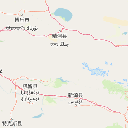
Map view of Xinjiang Ganjiahu Haloxylon National Nature Reserve

Use this park location map to pinpoint Xinjiang Ganjiahu Haloxylon National Nature Reserve in China, understand its exact geographic position, and read its mapped placement within the surrounding landscape more clearly.

Pigeon | © OpenStreetMap contributors

Location context for Xinjiang Ganjiahu Haloxylon National Nature Reserve

Xinjiang
Park atlas

Compare nearby protected areas and related desert reserves across the regional terrain

Exploring Parks Near 新疆甘家湖梭梭林国家级自然保护区 and Surrounding Desert Landscapes

Browsing other protected areas near 新疆甘家湖梭梭林国家级自然保护区 reveals connected desert ecosystems, ancient river corridors, and wind-shaped basin terrain. Extending the search across surrounding regional landscapes helps place individual saxaul woodlands into a broader conservation context.
Nature reserveTacheng Prefecture
About 127 km away#1 closest

Northwest

Xinjiang Barkol Mountain National Nature Reserve: Protected Terrain and Regional Geography

Mountain forest sanctuary in Tacheng Prefecture, Xinjiang

The Xinjiang Barkol Mountain National Nature Reserve protects a diverse mountain environment where the Barkol range captures moisture-bearing winds. Known for its globally significant stands of wild almond and Xinjiang wild apple, the reserve features a complex landscape of rocky ridges, forested slopes, and deep river valleys that sustain rare montane species and resilient endemic flora.

Area
1,150.37 km²
Established
1980
Relief
Mountain
Climate
Temperate
Nature reserveXinjiang Uyghur Autonomous Region
About 186 km away#2 closest

West

新疆霍城四爪陆龟国家级自然保护区: Mapped Landscape and Tianshan Foothills Geography

Nature reserve boundaries within the Xinjiang Uyghur Autonomous Region

Located in the Xinjiang Uyghur Autonomous Region, the 新疆霍城四爪陆龟国家级自然保护区 represents a unique loess hill ecosystem. This atlas profile details the protected boundaries, erosion-carved terrain, and the semi-arid sagebrush steppe habitat essential for the four-clawed tortoise population, providing deep geographic context for this national nature reserve.

Area
350 km²
Established
1983
Relief
Upland
Climate
Arid
Nature reserveXinjiang
About 188 km away#3 closest

Southwest

新疆伊犁小叶白蜡国家级自然保护区: Regional Protected Landscape and Tianshan Mountain Geography

Conservation focus on rare riparian ash forest ecosystems in Xinjiang

Spanning the alluvial floodplains of the Kashi and Ili Rivers, this nature reserve is a scientific stronghold for the narrow-leaved ash. The protected area showcases multi-generational forest structures and diverse ancient plant lineages, shaped by a sheltered Tianshan valley microclimate that remains unusually humid for the arid landscapes of inland Xinjiang.

Area
91.03 km²
Established
1983
Relief
Mixed relief
Climate
Temperate
National parkEast Kazakhstan Region
About 193 km away#4 closest

Northwest

Tarbagatai National Park: Protected Landscape and Wild Fruit Tree Forests in East Kazakhstan Region

Explore the mapped boundaries and ecosystem of this national park.

Tarbagatai National Park is a protected area in East Kazakhstan recognized for its unique role in conserving wild fruit tree forests that have maintained genetic isolation. This national park provides a detailed view of a mountain-steppe ecosystem across the Tarbagatai mountain range, Karabas Mountains, and Arkaly Mountains, along with the Urzhar and Emel river valleys. Its establishment in 2018 highlights its importance for biodiversity and the study of natural forest genetics, offering significant geographic context for regional protected land exploration.

Area
1,364 km²
Established
2018
IUCN
II
Relief
Mountain
Nature reserveGongliu County
About 195 km away#5 closest

South

Xinjiang West Tianshan National Nature Reserve: Protected Landscape and Mountain Terrain Map

A high-altitude forest and mountain nature reserve in Gongliu County.

This nature reserve encompasses a vast altitudinal range and complex river drainage systems in the western Tianshan. It is defined by its deep river gorges, glaciated peaks, and ancient spruce stands, functioning as a moist island for diverse Central Asian flora and fauna within an otherwise arid regional geography.

Area
312.17 km²
Established
1983
Relief
Mountain
Climate
Temperate
A soft watercolor illustration depicting a landscape of rolling green hills meeting a large body of water under a light sky.
Nature reserveKazakhstan
About 201 km away#6 closest

Northwest

Alakol Nature Reserve: Mapped Protected Landscapes and Wetland Geography in Kazakhstan

Protected lake basin and avian flyway conservation site.

Alakol Nature Reserve offers a deep look into the desert-wetland interface of southeastern Kazakhstan. Centered on the Tentek River delta and Lake Alakol islands, the reserve safeguards rare colonial bird habitats within a striking arid tectonic basin. Discover the geographic interplay between saline flats, riparian vegetation, and expansive lake environments that define this international conservation site.

Area
656.72 km²
Established
1998
IUCN
Ia
Relief
Lowland
Nature reserveXinjiang
About 241 km away#7 closest

West

Xinjiang Wenquan Xinjiang Salamander National Nature Reserve Protected Landscape and Atlas Geography

A vital montane spring and alpine grassland protected area in the Western Tianshan.

The Xinjiang Wenquan Xinjiang Salamander National Nature Reserve serves as a dedicated refuge for relict amphibian populations within the Tianshan mountain system. Its small footprint concentrates on preserving the integrity of cold-water spring brooks and snowmelt-driven seepage zones that form the backbone of this regional ecosystem. The reserve provides a clear example of targeted habitat management within the diverse topography of northwestern China.

Area
6.95 km²
Established
1997
Relief
Mountain
Climate
Arid
Watercolor painting depicting a mountain range, lake, and grassy foreground under a pale sky
National parkAlmaty Region
About 280 km away#8 closest

West

Zhongar-Alatau National Park: Protected Mountain Landscape and Genetic Heritage Atlas

Almaty Region's critical wild apple forest and glaciated terrain.

Zhongar-Alatau National Park in Kazakhstan's Almaty Region is a significant protected landscape renowned for its role in conserving the genetic origins of cultivated apples. The park encompasses dramatic glaciated mountain ranges, deep canyons, and diverse ecosystems within the Dzungarian Alatau. Its mapped boundaries define an area vital for protecting unique wild fruit tree species, including the Sievers apple, and preserving the distinctive alpine terrain of southeastern Kazakhstan, offering rich context for geographic exploration.

Area
36 km²
Established
2010
IUCN
II
Relief
Mountain

Common questions about visiting, size, designation, and location context for Xinjiang Ganjiahu Haloxylon National Nature Reserve

Xinjiang Ganjiahu Haloxylon National Nature Reserve FAQs for park facts, access, geography, and protected area context

Find quick answers about Xinjiang Ganjiahu Haloxylon National Nature Reserve, including protected-area facts, park geography, trail and visitor context, and how the park fits into its surrounding country and regional landscape.
MoriAtlas Explorer

Continue Your Protected Areas Search Across the Global Atlas

Deepen your exploration by continuing the structured search for national parks and protected areas worldwide. Utilize the comprehensive filtering capabilities to compare different conservation landscapes and refine your understanding of global park geography. Discover more about the distribution and characteristics of protected natural areas.

Global natural geography