Mori Atlas logo
Wildlife reserveÁrea de Protección de Flora y Fauna Yum Balam

Explore the geographic mosaic of mangrove channels, tropical forests, and inland lagoons near the Yucatan coast.

Área de Protección de Flora y Fauna Yum Balam: Mapping the Protected Landscapes of Northern Quintana Roo

(Area de Proteccion de Flora y Fauna Yum Balam)

Área de Protección de Flora y Fauna Yum Balam represents a vital ecological corridor located at the northeastern tip of the Yucatan Peninsula in Quintana Roo. This wildlife reserve protects a diverse terrain of semideciduous forests, freshwater wetlands, and the extensive Laguna de Yalahau lagoon system. Mapping these protected boundaries reveals a unique convergence where northern Yucatan tropical forests transition into Caribbean coastal ecosystems.

mangroveswetlandstropical forestlagoonflamingosCaribbean coast

Área de Protección de Flora y Fauna Yum Balam

Wildlife reserve

Park overview

Structured park overview, official facts, and landscape profile for Area de Proteccion de Flora y Fauna Yum Balam

Area de Proteccion de Flora y Fauna Yum Balam park facts, protected area profile, and essential visitor context

Review the core facts for Area de Proteccion de Flora y Fauna Yum Balam, including designation, size, terrain, visitor scale, habitats, and operating context in one park-focused overview.

About Area de Proteccion de Flora y Fauna Yum Balam

Yum Balam is a federal Mexican protected natural area located at the northern tip of the Yucatan Peninsula, occupying a strategic position in northern Quintana Roo that bridges mainland tropical ecosystems with the Caribbean islands of the region. Created in 1994, it reflects Mexico's approach to conserving areas of high biodiversity value through the Area de Proteccion de Flora y Fauna category, which allows regulated use alongside conservation objectives.

The protected area is defined by the Laguna de Yalahau and the surrounding natural systems that make this corner of the Yucatan ecologically distinctive. Mangroves fringe the lagoons and coastal stretches, while freshwater wetlands and seasonal marshes, locally known as tulares, add layers of aquatic habitat. Inland, the landscape transitions into low and medium semideciduous tropical forests that characterize the northern Yucatan, shaped by the region's flat karst geology, shallow soils, and seasonal rainfall.

The climate of Yum Balam is warm and humid, with rainfall distributed throughout the year, supporting both evergreen forest patches and seasonal wetland dynamics. These conditions sustain an unusually high concentration of species for a relatively compact area, including more than 1,100 recorded plants and animals according to Mexico's national biodiversity inventory. The protected area is also an important refuge for emblematic Yucatan species such as the ocellated turkey, spider monkey, jaguar, puma, and ocelot, alongside coastal and aquatic wildlife including manatees, sea turtles, and large flocks of flamingos and other waterbirds.

Yum Balam sits adjacent to and partly overlaps the territory of Holbox Island, one of the most recognizable destinations of northern Quintana Roo. The relationship between the reserve and the island region reinforces its ecological importance, since the wetlands, mangroves, and shallow coastal waters that surround the area are vital for migratory birds, fish, and marine fauna. As a result, Yum Balam is both a terrestrial stronghold for Yucatan forest biodiversity and a coastal and wetland sanctuary at the edge of the Caribbean Sea.

Quick facts and research context for Area de Proteccion de Flora y Fauna Yum Balam

Yum Balam was established as a federal Area de Proteccion de Flora y Fauna on June 6, 1994. It lies at the far northeastern end of the Yucatan Peninsula, in the northern part of Quintana Roo, covering areas within the municipalities of Lazaro Cardenas and Isla Mujeres. The protected zone incorporates the Laguna de Yalahau, surrounding mangroves, freshwater wetlands, and the low and medium tropical forests typical of the northern Yucatan.

According to Mexico's national biodiversity information system, the area hosts more than 1,100 recorded plant and animal species, among which a notable share fall within risk categories under Mexican environmental norms. The landscape blends karstic Yucatan forests, brackish mangrove systems, inland lagoons, and Caribbean coastal habitats, making it an important convergence zone for freshwater, estuarine, and marine biodiversity in the region.

Protection and recognition

Documented protection scope and international Ramsar recognition records for Yum Balam

Área de Protección de Flora y Fauna Yum Balam Protection Status and International Recognition

Protected area designation details for Área de Protección de Flora y Fauna Yum Balam include a mixed management scope and verified Ramsar recognition sources. Structured conservation records outline the international status and administrative framework associated with this natural reserve.

International recognition

Protection details

Protection scope
Mixed
Transboundary protection
No
Park context

Deeper park guide and search-rich context for Area de Proteccion de Flora y Fauna Yum Balam

Area de Proteccion de Flora y Fauna Yum Balam history, landscape, wildlife, and travel context

Explore Area de Proteccion de Flora y Fauna Yum Balam through its history, landscape character, ecosystems, wildlife, conservation priorities, cultural context, and seasonal travel timing in a structured park guide built for atlas discovery and search intent.

Why Area de Proteccion de Flora y Fauna Yum Balam stands out

Yum Balam is especially known for the Laguna de Yalahau and its surrounding mangrove and wetland systems, which support large colonies of flamingos and a broad community of wading birds, waterfowl, raptors, and migratory species. The protected area is also recognized for its northern Yucatan tropical forests and their characteristic tree species, such as the chicle tree, Campeche wood, Ramon, and native cedars. Beyond its wetlands and forests, Yum Balam is valued as one of the key protected landscapes at the northern tip of the Yucatan Peninsula, where marine and terrestrial ecosystems meet near Holbox Island and the offshore Caribbean islands. This combination of inland lagoon, mangrove, forest, and coastal sea creates one of the most biologically diverse protected mosaics in Quintana Roo.
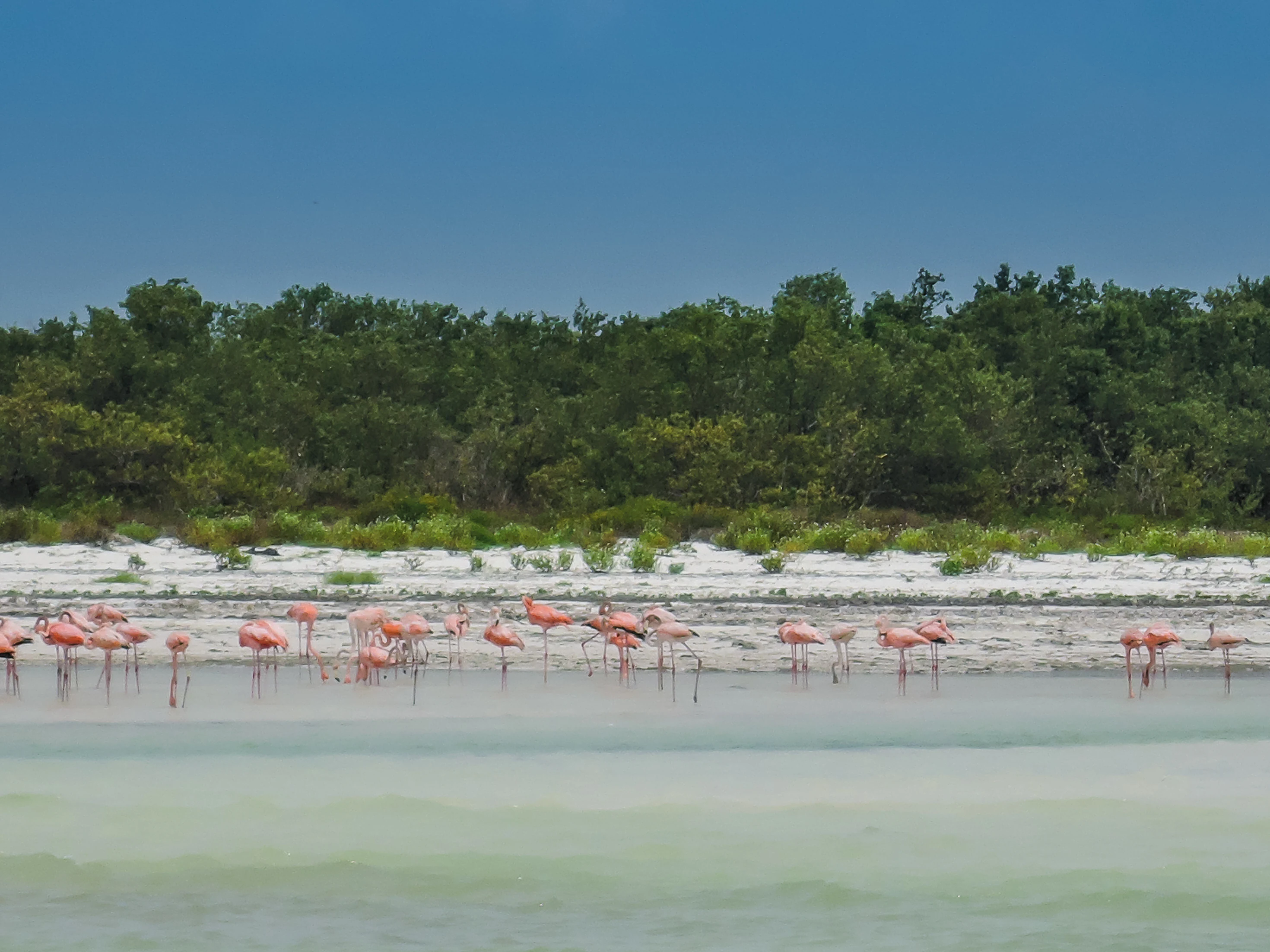
A group of pink flamingos wading in calm, shallow water in front of a sandy shoreline backed by dense green vegetation under a clear blue sky.
A flock of flamingos congregating in the shallow coastal waters of Holbox Island within the Yum Balam protected area.

Area de Proteccion de Flora y Fauna Yum Balam history and protected-area timeline

Yum Balam was established as a federal Area de Proteccion de Flora y Fauna on June 6, 1994, as part of Mexico's national program to safeguard representative and ecologically important ecosystems. Its creation recognized the exceptional concentration of tropical forest, mangrove, and wetland habitats at the northeastern tip of the Yucatan Peninsula, combined with the presence of culturally and economically significant plant species like the chicle tree.

The area's protection history is closely linked to the broader identity of northern Quintana Roo, where traditional extraction of chicle, hardwoods, and coastal fisheries has long shaped the relationship between local communities and the landscape. Designating Yum Balam allowed federal authorities to regulate land use in this transition zone between terrestrial ecosystems and the Caribbean Sea, ensuring that forestry, fishing, and tourism activities could continue under a conservation framework.

Since its establishment, the protected area has also been recognized as an important site for scientific documentation. National biodiversity institutions, including Mexico's commission for biodiversity knowledge and use, have catalogued more than a thousand species within its boundaries, reinforcing its role as a reference area for understanding the flora and fauna of the northern Yucatan.

Area de Proteccion de Flora y Fauna Yum Balam landscape and geographic character

The landscape of Yum Balam is shaped by the characteristic flat topography of the northern Yucatan Peninsula. Karstic limestone bedrock lies close to the surface, supporting shallow soils that sustain low and medium semideciduous tropical forests rather than tall dense jungle. These forests create a distinctive open-canopy environment dotted with hardwoods, palms, and useful species such as the chicle tree, Ramon, and Campeche wood.

A central feature of the protected area is the Laguna de Yalahau, a broad inland lagoon system surrounded by mangroves and freshwater wetlands. Around the lagoon, extensive zones of tule and other emergent aquatic vegetation create a mosaic of open water, marshland, and swamp forest typical of Yucatan lowlands. To the north and west, the landscape transitions gradually into coastal flats and the mangrove channels that fringe the Caribbean shoreline.

The overall scenery combines inland lagoons, dense mangrove corridors, marshy wetlands, and gently undulating forested plains. The proximity to the Caribbean Sea and to barrier islands such as Holbox and Contoy adds a marine dimension to the landscape, with shallow bays, sandy cays, and tidal flats forming part of the broader visual and ecological character of the protected area.

Area de Proteccion de Flora y Fauna Yum Balam ecosystems, habitats, and plant life

Yum Balam protects a remarkably compact convergence of three major ecosystem types from the northern Yucatan Peninsula: low and medium tropical forests, extensive mangrove systems, and freshwater wetlands. This combination of terrestrial and aquatic habitats within a relatively small geographical footprint gives the reserve unusually high ecological diversity for the region.

The forests of Yum Balam are typical of northern Quintana Roo, with semideciduous canopy species adapted to the shallow, rocky soils and seasonal rainfall of the karstic peninsula. Important native trees include the chicle tree, Campeche wood, local cedar, Ramon, and wetland-edge palms, while freshwater marsh habitats are dominated by dense stands of tule. Mangrove forests fringe the lagoons, estuaries, and coastal channels, providing critical nursery habitat for fish, crustaceans, and birds.

The wetlands and lagoons create the reserve's signature ecological profile. Inland waters like the Laguna de Yalahau, combined with tidal mangroves and coastal marshes, form a connected hydrological system that supports a wide variety of aquatic birds, fish, and other wildlife. This mosaic of forest, mangrove, marsh, and open water also makes the area an important refuge during seasonal changes, when water levels shift and different habitats become more or less accessible to local fauna.

Area de Proteccion de Flora y Fauna Yum Balam wildlife and species highlights

The wildlife of Yum Balam reflects the diversity of its forest, mangrove, and wetland habitats. Documented fauna within the protected area includes both terrestrial mammals and an exceptionally rich bird community. Iconic mammals such as the jaguar, puma, ocelot, and spider monkey inhabit the forested interior, while aquatic and semi-aquatic species like the manatee and various crocodile relatives are present in the lagoons, mangroves, and coastal waters.

The wetlands and lagoons support one of the most visible wildlife features of the reserve: large colonies of flamingos, alongside herons, storks, pelicans, gulls, ducks, and a wide variety of shorebirds. Raptors such as the peregrine falcon and other bird species like the Great Curassow (hocofaisán) also use the area, taking advantage of the mosaic of open water, marshland, and forest edge.

Marine and coastal wildlife is equally important to the reserve's identity. Sea turtles inhabit the coastal waters and nesting beaches, while the mangrove channels and shallow sea grass areas provide feeding grounds for manatees and juvenile fish. The combination of these terrestrial, freshwater, estuarine, and marine faunas makes Yum Balam a key site for understanding wildlife in the northern Yucatan.

Area de Proteccion de Flora y Fauna Yum Balam conservation status and protection priorities

Yum Balam is a cornerstone of biodiversity conservation in northern Quintana Roo, designated as a federal protected area to safeguard a representative sample of northern Yucatan ecosystems. Its importance lies in protecting not just a single habitat, but an interconnected mosaic of forest, wetland, mangrove, and coastal marine environments, which together sustain regional ecological processes such as water filtration, fish breeding, and migratory bird cycles.

The reserve also has cultural and economic conservation significance, since it protects tree species of long-standing regional importance, including the chicle tree, Campeche wood, and local cedar. By regulating forestry and extractive activities within its boundaries, Yum Balam helps maintain sustainable use of these resources while preserving forest cover and watershed integrity.

National biodiversity assessments have documented more than 1,100 species within the area, with a notable proportion of them falling under Mexican risk categories, which highlights the conservation importance of the reserve. The convergence of rare, endemic, and threatened species across such a compact area makes Yum Balam a critical node for broader conservation strategies in the Yucatan Peninsula and the Caribbean coastal region of Mexico.

Area de Proteccion de Flora y Fauna Yum Balam cultural meaning and human context

Yum Balam sits within a region with deep cultural and historical ties to the tropical forests of northern Quintana Roo. The forests of this area have long supported the traditional extraction of chicle for chewing gum production, along with hardwoods and other non-timber forest products that have shaped local livelihoods for generations. The presence of culturally significant species like the chicle tree, Ramon, and Campeche wood reflects this long-standing relationship between communities and the forest.

The northern Yucatan coastline and its islands, including Holbox and the area around Isla Mujeres, also have strong fisher and coastal community traditions. The protection of Yum Balam integrates these traditional activities, recognizing that the same wetlands, mangroves, and coastal waters that sustain wildlife also sustain local economies through small-scale fishing, ecotourism, and forest-based activities. This blend of conservation and regional identity is central to how the protected area is understood locally.

Top sights and standout views in Area de Proteccion de Flora y Fauna Yum Balam

Yum Balam stands out for the way it compresses an entire cross-section of northern Yucatan ecosystems into a single protected area, from semideciduous tropical forest and hardwood-rich woodland to mangroves, freshwater wetlands, and Caribbean coastal waters.

Its signature attraction is the Laguna de Yalahau and its flamingo-rich wetlands, framed by extensive mangrove corridors and forest patches that together form one of the most diverse bird habitats in northern Quintana Roo. Combined with the protected area's role as a refuge for jaguars, spider monkeys, manatees, and sea turtles, Yum Balam offers a uniquely balanced portrait of Yucatan nature, where terrestrial, aquatic, and marine worlds meet at the edge of the peninsula.

Best time to visit Area de Proteccion de Flora y Fauna Yum Balam

The climate of Yum Balam is warm and humid year-round, with rainfall distributed across all seasons, so the protected area can be appreciated in any period. Wildlife viewing, particularly of flamingos and other waterbirds around the Laguna de Yalahau and the coastal wetlands, is often strongest in the drier months, when water levels concentrate birds in more predictable areas and forest trails are easier to traverse.

The wetter months bring lusher vegetation and active forest growth, which can enhance the scenic quality of the tropical forests and make freshwater wetlands more expansive. Because the reserve lies at the convergence of lagoon, mangrove, forest, and sea, seasonal shifts change the visual and ecological character of each habitat rather than closing access to the area, which makes the timing of a visit a matter of preference for scenery, bird conditions, or forest atmosphere.
Monthly climate preview

Long term representative temperature and precipitation averages across the annual cycle

Climate Normals and Monthly Weather Patterns in Área de Protección de Flora y Fauna Yum Balam

Representative coordinate records show mean monthly temperatures ranging from 24.08 to 28.46 degrees Celsius alongside varied precipitation totals from 1.17 to 6.08 mm per day. Analyzing the complete twelve month profile provides deeper insight into long term thermal and moisture baselines for this protected area.
Annual mean26 °C
24 °C28 °C
Jan24°
Feb24°
Mar25°
Apr26°
May27°
Jun28°
Jul28°
Aug28°
Sep28°
Oct27°
Nov26°
Dec25°
Warmest month
August

28.5 °C

Coolest month
January

24.1 °C

Wettest month
October

6.1 mm/day

Driest month
March

1.2 mm/day

Park location guide

Geography guide, regional context, and park location map for Area de Proteccion de Flora y Fauna Yum Balam

Area de Proteccion de Flora y Fauna Yum Balam park geography, regions, and map view in Mexico

Understand where Area de Proteccion de Flora y Fauna Yum Balam sits in Mexico through a broader geographic reading of the surrounding landscape, nearby location context, and its mapped position within the national park landscape.

How Area de Proteccion de Flora y Fauna Yum Balam fits into Mexico

Mexico, officially the United Mexican States, is a country in North America spanning the Sierra Madre mountain ranges, coastal plains, and tropical regions. It borders the United States to the north, Guatemala and Belize to the southeast, and has coastlines along the Pacific Ocean, Gulf of Mexico, and Caribbean Sea. With a population exceeding 130 million, Mexico is home to one of the world's most significant concentrations of Indigenous languages alongside Spanish.

Wider geography shaping Area de Proteccion de Flora y Fauna Yum Balam in Mexico

Mexico occupies a land area of 1,972,550 km2, making it the thirteenth-largest country in the world. The terrain is highly diverse, featuring the Sierra Madre Occidental and Sierra Madre Oriental mountain ranges, the Mexican Plateau, coastal lowlands along the Pacific and Gulf/Caribbean margins, and the Yucatan Peninsula. The country spans multiple climate zones from desert in the north to tropical rainforest in the south.

Map view of Area de Proteccion de Flora y Fauna Yum Balam

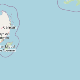
Use this park location map to pinpoint Area de Proteccion de Flora y Fauna Yum Balam in Mexico, understand its exact geographic position, and read its mapped placement within the surrounding landscape more clearly.

Pigeon | © OpenStreetMap contributors

Location context for Area de Proteccion de Flora y Fauna Yum Balam

Quintana Roo

Visual reference guide featuring northern Yucatan tropical forests, coastal lagoons, and mangrove habitats

Área de Protección de Flora y Fauna Yum Balam Photos and Protected Landscape Scenery

Visual documentation captures the diverse protected environments of Área de Protección de Flora y Fauna Yum Balam, including extensive mangrove corridors, inland lagoons, and coastal wetlands. Detailed photographic records help researchers and travelers examine the distinct topography and ecological character of this northern Yucatan natural reserve.

A group of pink flamingos wading in calm, shallow water in front of a sandy shoreline backed by dense green vegetation under a clear blue sky.

Park atlas

Compare surrounding coastal reserves, mangrove networks, and tropical forest sanctuaries

Parks Near Área de Protección de Flora y Fauna Yum Balam and Regional Protected Areas

Browse protected areas adjacent to Área de Protección de Flora y Fauna Yum Balam to evaluate regional ecosystems and coastal wildlife habitats. Examining these neighboring reserves provides deeper geographic context for the northern Yucatan Peninsula.
Watercolor painting showing layered mountains, green valleys, and a river
National parkQuintana Roo
About 102 km away#1 closest

South

Arrecifes de Cozumel National Park: National Park Protected Landscape and Map Exploration

Discover the geographic boundaries and regional context.

Arrecifes de Cozumel National Park represents a significant protected national park within the Quintana Roo region. This page provides detailed atlas-style information about its protected landscape, enabling users to explore its defined boundaries and understand its place in the broader geographic context of Mexico. Discover the mapped terrain and the structured facts that illuminate this vital conservation area.

Area
120 km²
Established
1996
IUCN
II
Climate
Tropical
Watercolor illustration of a coastal mangrove ecosystem with calm water, green vegetation, and soft pink and green tones.
Biosphere reserveQuintana Roo
About 146 km away#2 closest

South

Sian Ka'an Biosphere Reserve: Geographic Map and Protected Landscape Overview

Quintana Roo, Mexico coastal wetland and reef geography

Sian Ka'an Biosphere Reserve protects a diverse coastal environment in Quintana Roo, characterized by low-relief limestone terrain, flooded savannas, and the expansive Mesoamerican Barrier Reef. This entry provides a structured look at the reserve's protected land boundaries, petenes ecosystems, and integrated Maya archaeological corridors found throughout this tropical territory.

Area
5,281.47 km²
Established
1986
Relief
Lowland
Climate
Tropical
National parkMexico
About 259 km away#3 closest

West

Dzibilchantún National Park: Protected Landscape in Mexico's Atlas

Mapped boundaries and regional geography for this national park.

Delve into the protected landscape of Dzibilchantún National Park, a significant national park situated within Mexico. This entry offers a detailed look at its geographic positioning, mapped park boundaries, and its role within the national atlas of protected areas. Understand the specific landscape context and regional geography that define Dzibilchantún National Park for comprehensive exploration.

Area
5.39 km²
IUCN
II
Relief
Lowland
Climate
Tropical
A watercolor painting showing soft, rolling hills in the distance with a marshy wetland and patches of greenery in the foreground.
Nature reserveYucatán
About 268 km away#4 closest

West

Cuxtal Ecological Reserve: Mapping the Protected Landscape and Geography of Yucatán

Nature reserve featuring critical groundwater recharge and historic cultural sites.

Cuxtal Ecological Reserve represents a significant protected area in Yucatán, Mexico, known for its strategic role in supplying water to Mérida. The landscape encompasses a vast expanse of seasonally dry low deciduous forest, interspersed with limestone karst formations, historic hacienda complexes, and archaeological remnants. This unique reserve provides essential habitats for migratory birds and local fauna while demonstrating the integration of environmental research, cultural heritage, and sustainable land management in a rapidly developing region.

Area
107.57 km²
Established
1993
Relief
Lowland
Climate
Tropical
National parkMexico
About 287 km away#5 closest

Northwest

Arrecife Alacranes National Park: Protected Marine National Park Geography

Explore its mapped boundaries and regional significance.

Arrecife Alacranes National Park stands as a critical protected marine area within Mexico's national park system. This entity offers detailed geographic context for understanding protected landscapes, focusing on its mapped boundaries and the unique marine environment it encompasses. For those exploring national parks and their atlas representation, Arrecife Alacranes National Park provides a specific case study in marine conservation geography, highlighting its role within the broader Mexican landscape.

IUCN
II
Relief
Lowland
Scope
Marine
Water
Water-dominated
National parkAmbergris Caye
About 370 km away#6 closest

South

Bacalar Chico National Park and Marine Reserve: Belize National Park & Marine Reserve Atlas

Explore Ambergris Caye's unique barrier island and reef geography.

Discover the extensive protected territory of Bacalar Chico National Park and Marine Reserve, a critical national park and marine reserve situated on Ambergris Caye, Belize. This protected area showcases a rich diversity of landscapes, from rare littoral forests and inland wetlands to vital coral reefs and sea grass beds integral to the Mesoamerican Barrier Reef System. Its unique geographic position and ecological significance make it a key destination for understanding Belize's conservation landscapes and mapped marine environments.

Area
62.8 km²
Established
1996
IUCN
IV
Relief
Lowland
A stylized vector illustration of tiered Mayan pyramid structures rising above a dense green jungle landscape under a soft pastel sky.
Biosphere reservePetén Department
About 451 km away#7 closest

Southwest

Maya Biosphere Reserve: Geographic Overview and Protected Landscapes in Petén

Tropical forest ecosystems and ancient archaeological mapping

Covering roughly one-fifth of Guatemala, the Maya Biosphere Reserve represents a pioneering model of zoned conservation. The landscape features a complex mosaic of lowland rainforests, savanna patches, and seasonal wetlands formed over a weathered limestone platform. This atlas summary examines the reserve's ecological boundaries, its vital role in protecting Mesoamerican biodiversity, and the concentration of pre-Columbian cities located across the Petén Department.

Area
21,602 km²
Established
1990
Relief
Mixed relief
Climate
Tropical
National parkCayo District
About 490 km away#8 closest

South

Guanacaste National Park National Park: Explore its Protected Landscape and Geographic Setting

Mapped natural terrain and regional context within Cayo District.

Delve into the specifics of Guanacaste National Park, a protected national park located in the Cayo District of Belize. This detail page is designed for atlas exploration, offering insights into the park's geographic boundaries and its significance as a defined natural landscape. Understand how this protected area fits into the regional geography and contributes to the mapped natural heritage of Belize.

Area
0.2 km²
Established
1973
IUCN
II
Climate
Tropical

Common questions about visiting, size, designation, and location context for Area de Proteccion de Flora y Fauna Yum Balam

Area de Proteccion de Flora y Fauna Yum Balam FAQs for park facts, access, geography, and protected area context

Find quick answers about Area de Proteccion de Flora y Fauna Yum Balam, including protected-area facts, park geography, trail and visitor context, and how the park fits into its surrounding country and regional landscape.
MoriAtlas Explorer

Continue Your Protected Areas Search Across the Global Atlas

Deepen your exploration by continuing the structured search for national parks and protected areas worldwide. Utilize the comprehensive filtering capabilities to compare different conservation landscapes and refine your understanding of global park geography. Discover more about the distribution and characteristics of protected natural areas.

Global natural geography