
Mori Atlas logo
Protected landscape郑州黄河风景名胜区

Tracing the transition from loess highland ridges to the expansive alluvial river floodplain

郑州黄河风景名胜区: A Definitive Protected Landscape Mapping the Yellow River Basin in Henan

The 郑州黄河风景名胜区 serves as a critical geographic marker in Henan, where the distinct loess highlands of Mang Mountain overlook the broad, slow-moving stretches of the Yellow River. This protected landscape captures the intersection of monumental heritage and natural riverine terrain, offering a unique vantage point to understand the regional geography of the Central Plains. Through its elevation changes and river-facing ridges, the area provides a layered perspective on how natural features and historical river crossings define the character of the surrounding landscape.

yellow riverriver valleyloess highlandsmountain ridgesnational geoparkcultural landscape
An illustration in a flat design style depicting a river with lily pads, a waterfall, a bridge, a forest, and a mountain range with two large, carved human faces resembling mountain monuments.

郑州黄河风景名胜区

Protected landscape

Park overview

Structured park overview, official facts, and landscape profile for Zhengzhou Yellow River Scenic Area

Zhengzhou Yellow River Scenic Area park facts, protected area profile, and essential visitor context

Review the core facts for Zhengzhou Yellow River Scenic Area, including designation, size, terrain, visitor scale, habitats, and operating context in one park-focused overview.

About Zhengzhou Yellow River Scenic Area

The Zhengzhou Yellow River Scenic Area is a major integrated cultural-natural site in northern Zhengzhou, situated where the loess highlands of Mang and Yue mountains descend toward the Yellow River. Originally a barren stretch of the Mang range, the area was transformed after Mao Zedong's 1952 inspection of the Yellow River, when local authorities initiated large-scale afforestation and the construction of pavilions, sculptures, and recreational facilities. Over the following decades the site evolved from a simple river outlook into a comprehensive scenic zone blending riverine landscape, reclaimed green hillsides, and a series of monumental cultural artworks.

The park is structured around several principal zones, each expressing a different facet of the Yellow River cultural narrative. Wulong Peak, at the heart of the scenic area, gathers five ridges around a central valley and houses the famous white marble Yellow River Mother sculpture, symbolizing the nourishment of Chinese civilization by the river. Nearby, Camel Ridge is named for the silhouette of its mountain and topped by a monumental statue of Great Yu, the legendary flood-taming founder of Xia dynasty order, gazing eastward across the river toward the plains. Higher up, Yueshan Temple and its small peak provide one of the most commanding panoramic viewpoints over both the Yellow River and the original Peking-Hankou railway bridge, anchoring the site to a deeper modern history.

Cultural symbolism is central to the site's identity. The Yan-Huang Emperors sculpture, carved from real Taihang Mountain stone and completed in 2007 after two decades of planning, embodies the mythic founders of the Chinese nation. The accompanying Yan-Huang Ding bronze cauldron carries inscriptions from senior Chinese leaders and reinforces the site's role as a statement of civilizational heritage. Together with later commemorative features like the Baoguo Pavilion, built to honor the sacrifices of Chinese Nationalist soldiers during the Second Sino-Japanese War, the scenic area functions less as a wilderness park and more as a curated cultural landscape along one of China's most symbolically important rivers.

Quick facts and research context for Zhengzhou Yellow River Scenic Area

The Zhengzhou Yellow River Scenic Area lies in Huiji District of Zhengzhou, Henan Province, spanning roughly 20 square kilometers along the southern bank of the Yellow River at the foot of Mang Mountain. It combines natural scenery of the Yellow River basin with extensive cultural monuments and sits adjacent to the historic site of Mao Zedong's 1952 inspection of the Yellow River. The area is classified as a national-grade scenic zone, a National AAAA tourist attraction, and a National Geopark.

Protection and recognition

Terrestrial protection metrics and international recognition records for 郑州黄河风景名胜区

郑州黄河风景名胜区 Protection Status and Documented Conservation Scope

Examine the verified protection status, management scope, and official designation history established for 郑州黄河风景名胜区. Structured conservation records provide clear insight into terrestrial boundaries and international recognition frameworks.

Protection details

Protection scope
Terrestrial
Transboundary protection
No
Park context

Deeper park guide and search-rich context for Zhengzhou Yellow River Scenic Area

Zhengzhou Yellow River Scenic Area history, landscape, wildlife, and travel context

Explore Zhengzhou Yellow River Scenic Area through its history, landscape character, ecosystems, wildlife, conservation priorities, cultural context, and seasonal travel timing in a structured park guide built for atlas discovery and search intent.

Why Zhengzhou Yellow River Scenic Area stands out

The area is best known for the colossal Yan and Huang Emperors sculpture, one of the largest figurative monuments in the world, rising 106 meters above the surrounding hill. It is also recognized for the Yellow River Mother statue at Wulong Peak, the Great Yu statue overlooking Camel Ridge, and high vantage points offering sweeping views of the Yellow River and the historic Zhengzhou Yellow River Railway Bridge.
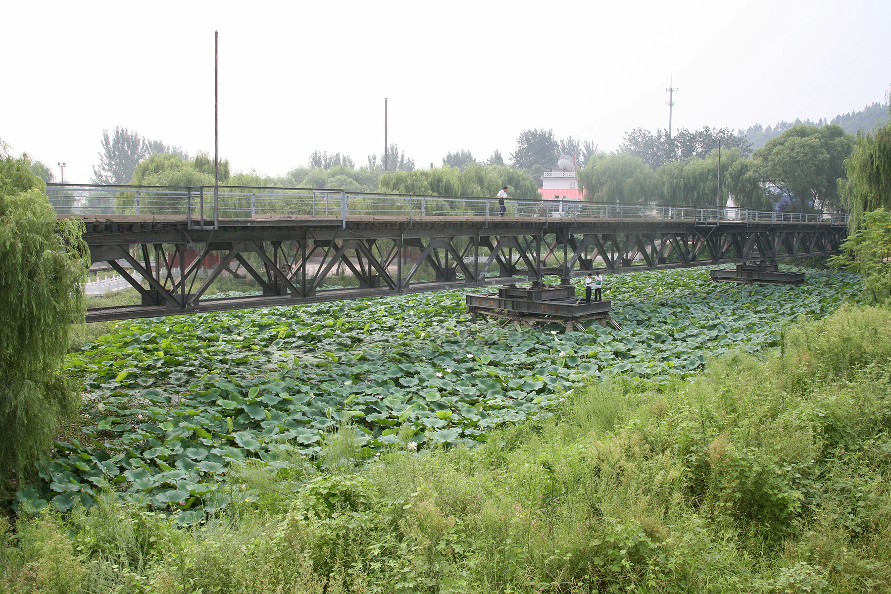
An old steel truss railway bridge crosses over a pond filled with lily pads, surrounded by lush green trees and vegetation.
Historical remains of the Peking-Hankow Railway bridge situated within the Zhengzhou Yellow River Scenic Area.

Zhengzhou Yellow River Scenic Area history and protected-area timeline

The history of the Zhengzhou Yellow River Scenic Area begins on October 31, 1952, when Mao Zedong ascended Xiaodingshan to observe the eastward flow of the Yellow River and declared that the problems of the Yellow River must be handled well. A photograph taken during that visit of Mao looking out at the Zhengzhou Yellow River Bridge became an iconic image of the site. In 1985, a standing statue of Mao was installed at the viewpoint, and in 2004, a heavier seated bronze statue replaced it to more faithfully recreate the moment of his inspection.

Parallel to this symbolic history, the region underwent significant infrastructural transformation. In 1970, in order to address Zhengzhou's chronic water shortages, construction began on the Mang Mountain Pumping Station, mobilizing roughly 100,000 workers and finishing in 1972. In 1974, the pumping station's party secretary Wang Renmin proposed developing the area into a scenic zone, leading to the creation of the Yellow River Mother sculpture and other early attractions. In 1981, the Zhengzhou municipal government officially redesignated the site as the Zhengzhou Yellow River Tourist Area, and by 1985 it was already welcoming over a million visitors annually.

In 1988, the site became one of the first provincial-level scenic areas in Henan, and in 2002 it was upgraded to National AAAA tourist attraction status and renamed the Zhengzhou Yellow River Scenic Area. Geological and earth-science recognition followed in 2005, when the Ministry of Land and Resources designated it a National Geopark, and in 2011 it was further recognized as a Ministry of Land and Resources science popularization base, cementing its status as a hybrid cultural-natural destination.

Zhengzhou Yellow River Scenic Area landscape and geographic character

The landscape of the scenic area is defined by the sharp transition between the Yellow River floodplain and the elevated loess highlands of Mang Mountain and Yueshan. From the riverbank, the terrain rises in a series of ridges and modest peaks, with Wulong Peak forming a multi-ridged central massif and Camel Ridge standing out for its distinctive camel-shaped silhouette. The hillsides, once described as barren, were extensively replanted, turning the area into a sustained green belt overlooking the river.

The river itself anchors the scenery. Wide, slow-moving stretches of the Yellow River pass along the northern edge of the park, and elevated lookout points, particularly near Yueshan Temple and Xiaodingshan, provide unobstructed views across the water. The presence of the historic Zhengzhou Yellow River Railway Bridge below the cliffs adds a strong industrial-historical layer to the otherwise natural horizon, where riverine flats meet cultivated plains stretching toward the east.

Zhengzhou Yellow River Scenic Area conservation status and protection priorities

The Zhengzhou Yellow River Scenic Area plays a dual conservation role. As a National Geopark, it protects a representative section of the Yellow River valley where loess uplands, river terraces, and bedrock ridges meet, offering documented geological exposures of the region's transitional landscape between the North China Plain and the western highlands. The park's reclamation of thousands of mu of formerly barren Mang Mountain hillsides into forested green slopes also represents a long-term ecological rehabilitation effort along the Yellow River corridor.

Beyond geology and reforestation, the area's protected status as a national-grade scenic zone and AAAA tourist attraction has helped frame the Yellow River itself here as a conserved landscape rather than merely an industrial waterway. The combination of geological, scenic, and cultural protection ensures that the riverbank environment around Zhengzhou is preserved as a coherent cultural-natural zone for future research, education, and public enjoyment.

Zhengzhou Yellow River Scenic Area cultural meaning and human context

The scenic area is deeply embedded in the cultural imagination of the Yellow River as the cradle of Chinese civilization. Sculptures of the Yan and Huang Emperors, the Yellow River Mother, and Great Yu connect the site to foundational myths of the Chinese nation, while the Yan-Huang Ding bronze cauldron reinforces this narrative through inscriptions from major modern Chinese leaders. The site's association with Mao Zedong's 1952 inspection further links it to the political symbolism of the People's Republic.

A more somber dimension of the site's cultural memory is preserved at the Baoguo Pavilion, erected in 1990 to commemorate Nationalist soldiers of the 38th Army who died fighting Japanese forces. The surviving piers of the original Peking-Hankou railway bridge beneath Yueshan Temple also serve as a reminder of early Republican-era engineering and wartime damage along the Yellow River, embedding modern Chinese history within the scenic landscape.

Top sights and standout views in Zhengzhou Yellow River Scenic Area

Key highlights of the Zhengzhou Yellow River Scenic Area include the towering Yan and Huang Emperors stone sculpture overlooking the hills, the symbolic Yan-Huang Ding bronze cauldron, the serene marble Yellow River Mother statue at Wulong Peak, and the commanding Great Yu statue atop Camel Ridge. Visitors also come for panoramic Yellow River views from Yueshan Temple and Xiaodingshan, the historic remains of the first railway bridge across the Yellow River, and the layered cultural symbolism that connects the site to both ancient myth and twentieth-century Chinese history.

Best time to visit Zhengzhou Yellow River Scenic Area

Spring and autumn are generally the most rewarding seasons to experience the Yellow River scenery at this site, when mild temperatures make long walks along the ridges and riverbank viewpoints comfortable and when the greenery of the reclaimed Mang Mountain hillsides is most visible. Summer can be hot and hazy along the river plain, while winter brings colder winds off the open Yellow River basin, reducing the appeal of the exposed viewing platforms. Visitors interested in the cultural events and ceremonies associated with the Yan-Huang sculpture will find the broader spring and early autumn windows particularly favorable.
Monthly climate preview

Measured annual temperature variation and monthly precipitation patterns at a representative coordinate in Henan

郑州黄河风景名胜区 Climate Normals and Long Term Weather by Month

Long term climatology records reveal marked temperature swings and distinct precipitation shifts across the twelve month cycle at the sampled coordinate. Examining the complete monthly normals provides deeper insight into the historical baseline conditions defining the local environment.
Annual mean15 °C
0 °C29 °C
Jan
Feb
Mar
Apr17°
May23°
Jun28°
Jul29°
Aug27°
Sep22°
Oct16°
Nov
Dec
Warmest month
July

29 °C

Coolest month
January

0.2 °C

Wettest month
July

4.5 mm/day

Driest month
December

0.2 mm/day

Park location guide

Geography guide, regional context, and park location map for Zhengzhou Yellow River Scenic Area

Zhengzhou Yellow River Scenic Area park geography, regions, and map view in China

Understand where Zhengzhou Yellow River Scenic Area sits in China through a broader geographic reading of the surrounding landscape, nearby location context, and its mapped position within the national park landscape.

How Zhengzhou Yellow River Scenic Area fits into China

China is a unitary communist state in East Asia, governed by the Chinese Communist Party. The country's capital is Beijing, while Shanghai is the largest city by urban population. China has 33 province-level divisions including provinces, autonomous regions, municipalities, and special administrative regions. The nation has a long history spanning thousands of years, with achievements including the invention of gunpowder, paper, printing, and the compass.

Wider geography shaping Zhengzhou Yellow River Scenic Area in China

China is located in East Asia, bordering fourteen countries: Russia, North Korea, Vietnam, Laos, Myanmar, India, Bhutan, Nepal, Pakistan, Afghanistan, Tajikistan, Kyrgyzstan, Kazakhstan, and Mongolia. The country spans diverse terrain including deserts, mountains, plateaus, and river valleys. Major river systems include the Yellow River and Yangtze River. The coastline stretches along the East China Sea, South China Sea, and Yellow Sea.

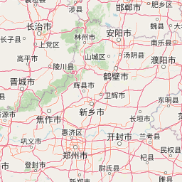
Map view of Zhengzhou Yellow River Scenic Area

Use this park location map to pinpoint Zhengzhou Yellow River Scenic Area in China, understand its exact geographic position, and read its mapped placement within the surrounding landscape more clearly.

Pigeon | © OpenStreetMap contributors

Location context for Zhengzhou Yellow River Scenic Area

Henan

Visual exploration of loess highlands, river valleys, and monument terrain

郑州黄河风景名胜区 Photos, Landscapes, and Protected Area Scenery

Visual records capture the striking transition where loess highlands meet broad river plains across 郑州黄河风景名胜区. Field photography reveals elevated ridge topography, monumental sculpture landmarks, and sweeping protected area vistas.

An old steel truss railway bridge crosses over a pond filled with lily pads, surrounded by lush green trees and vegetation.

A wide angle shot of the massive stone sculptures depicting two large human faces carved into the top of a hill, overlooking a tiered plaza at the Yellow River Scenic Area.

Park atlas

Compare regional river valleys, loess highlands, and connected natural terrain.

Explore Other Parks Near 郑州黄河风景名胜区 and Surrounding Protected Landscapes

Trace regional geography by comparing protected areas and national parks near 郑州黄河风景名胜区. Broader atlas navigation connects river valley reserves and upland terrain for comprehensive regional park discovery.
National parkChina
About 484 km away#1 closest

Southwest

Giant Panda National Park: China's Premier Panda Habitat and Protected Landscape

Mapped terrain and conservation significance in the mountains of western China.

Giant Panda National Park is a critically important protected area in China, established to conserve the primary habitat for the giant panda. This national park, spanning a vast mountainous region across Sichuan, Gansu, and Shaanxi, integrates numerous former reserves into a unified landscape. It serves as a vital sanctuary, protecting approximately 80 percent of the world's wild panda population and offering deep insights into the geographic distribution and ecological requirements of these endangered animals.

Area
27,134 km²
Established
2020
IUCN
II
Relief
Mountain
Nature reserveChina
About 562 km away#2 closest

West

Changqing Nature Reserve: Mountain Forest Geography and Conservation Mapping

A vital Qinling Range protected area in Shaanxi Province, China

This reserve provides a deep look at the biodiversity of the Qinling Mountains, featuring steep terrain, bamboo-rich slopes, and vital forest river corridors. It serves as a globally recognized model for protected area management and provides a habitat for rare species within its vertical landscape.

Area
300 km²
Established
1995
Relief
Mountain
Access
Access unknown
State or regional parkBeijing
About 611 km away#3 closest

North

Beijing Xishan National Forest Park: Atlas and Geographic Landscape Overview

Mapping the Western Hills forest and cultural landscape

Beijing Xishan National Forest Park offers a unique study of peri-urban conservation, featuring planted woodlands and rocky ridge terrain at the doorstep of the Chinese capital. This protected area bridges the metropolitan edge of Beijing with the eastern reaches of the Taihang Mountains, integrating historical sites with diverse seasonal forest flora. The park remains a primary example of how regional geography and cultural memory converge within a state-designated national forest zone.

Area
53.33 km²
Established
1992
Visitors
1.5M annual
Relief
Mountain
Protected areaHunan
About 678 km away#4 closest

Southwest

Wulingyuan Scenic and Historic Interest Area: Quartz-Sandstone Peak Forest and Protected Geography

Explore the tectonic landscape and forest-covered plateau in Hunan Province.

Wulingyuan Scenic and Historic Interest Area represents a massive protected landscape in Hunan, China, defined by its extraordinary density of quartz-sandstone pillars. This atlas record documents the geological signature of these vertical rock formations, the surrounding gorge networks, and the high-canopy forest environment that characterizes this significant regional landform.

Area
264 km²
Established
1982
Relief
Mountain
Climate
Subtropical
A watercolor illustration of rolling hills with scattered trees under a soft, light-filled sky.
Protected landscapeDalian
About 883 km away#5 closest

Northeast

Jinshitan National Resort: Exploring the Coastal Geopark and Protected Landscapes of Dalian

Ancient sedimentary rock formations and coastal terrain mapping

Investigate the complex geography of Jinshitan National Resort, a prominent coastal area in Dalian, China. This protected landscape combines natural heritage, including unique stone forest formations shaped by millions of years of erosion, with long, sloping golden beaches that define the regional coastline along the Yellow Sea.

Area
120 km²
Established
1984
Relief
Lowland
Climate
Temperate
A horizontal watercolor illustration depicting a soft, rolling landscape with green fields, a winding stream, a line of trees, and distant hills against a plain background.
National parkSichuan
About 893 km away#6 closest

West

Jiuzhaigou National Park: Mapped Geography and Protected Area Overview in Sichuan, China

Travertine terrace systems and high mountain forest landscapes

Located on the edge of the Qinghai-Tibet Plateau, Jiuzhaigou is a protected landscape characterized by a network of clear alpine lakes known as haizi and extensive coniferous forest blocks. The park showcases a rare interplay of water and mineral-rich rock, creating expansive travertine dams and cascading waterfalls across its three main gullies. This atlas entry focuses on the regional geography, habitat distribution, and natural terrain that constitute the essential character of this prominent conservation area within the Min Mountains.

Area
720 km²
Established
1978
Relief
Mountain
Climate
Alpine
Protected landscapeFujian
About 894 km away#7 closest

Southeast

Wuyi Mountains Protected Landscape: A Geographic Atlas of Subtropical Forests and Danxia Terrain

Mapped boundaries, regional geography, and ancient landscape context.

The Wuyi Mountains in Fujian, China, are a crucial protected landscape, recognized for their exceptional subtropical forest biodiversity and iconic Danxia landforms. This destination offers a detailed exploration of its mapped geography, including the striking red sandstone cliffs, meandering river valleys, and significant cave systems. Understand the park's protected boundaries and its role as a vital natural and cultural heritage site within China's regional geography, perfect for atlas-based discovery.

Area
1,278.63 km²
Established
1999
IUCN
II
Relief
Mountain
A soft, watercolor painting of a terraced landscape with shallow pools, grassy slopes, and distant tree-lined hills.
Protected areaSichuan
About 900 km away#8 closest

West

Huanglong Scenic and Historic Interest Area: Protected Alpine Landscapes and Travertine Map

High-altitude karst geography in the Minshan Mountains of Sichuan

Huanglong Scenic and Historic Interest Area presents a unique geological profile centered on a long valley of stepped travertine pools that cascade through alpine forests and meadows. This protected area offers a distinct look at the high-mountain geography of Sichuan, providing a clear view of how mineral-rich springs, deep canyons, and glaciated summits create a layered and ecologically significant environment for rare wildlife.

Area
600 km²
Established
1992

Common questions about visiting, size, designation, and location context for Zhengzhou Yellow River Scenic Area

Zhengzhou Yellow River Scenic Area FAQs for park facts, access, geography, and protected area context

Find quick answers about Zhengzhou Yellow River Scenic Area, including protected-area facts, park geography, trail and visitor context, and how the park fits into its surrounding country and regional landscape.
MoriAtlas Explorer

Continue Your Protected Areas Search Across the Global Atlas

Deepen your exploration by continuing the structured search for national parks and protected areas worldwide. Utilize the comprehensive filtering capabilities to compare different conservation landscapes and refine your understanding of global park geography. Discover more about the distribution and characteristics of protected natural areas.

Global natural geography