

Mori Atlas logo
National parkAo Siam National Park

Explore the mapped boundaries and regional natural context of this Thai national park.

Ao Siam National Park: Protected Landscape Geography in Prachuap Khiri Khan Province

Ao Siam National Park represents a distinct protected landscape within Thailand's Prachuap Khiri Khan Province. This page serves as a canonical entry point for understanding the park's geographic identity, its mapped natural terrain, and its role within the broader regional atlas of protected areas. Discover the core geographic features that define Ao Siam National Park and its setting on the Kra Isthmus.

Coastal National ParkGulf of ThailandIsland EcosystemsForest ParksSouthern ThailandPrachuap Khiri Khan

Ao Siam National Park

National park

Park overview

Structured park overview, official facts, and landscape profile for Ao Siam National Park

Ao Siam National Park park facts, protected area profile, and essential visitor context
Review the core facts for Ao Siam National Park, including designation, size, terrain, visitor scale, habitats, and operating context in one park-focused overview.

About Ao Siam National Park

Ao Siam National Park represents Thailand's effort to consolidate and elevate coastal protection status in a region of the Gulf of Thailand that has historically received less national park coverage than other parts of the country. The park is located in the southern-central portion of the western Gulf coast, within Prachuap Khiri Khan Province, one of Thailand's coastal provinces stretching along the upper Gulf. The territory includes both mainland forest areas that were previously designated under forest park status and a group of three small islands lying offshore in the gulf waters. The park's establishment represents a consolidation of multiple earlier protected area designations, specifically the former Pa Klang Ao Forest Park and Mae Ramphueng Forest Park, which have been incorporated into the broader national park framework. The governing body overseeing the park is Thailand's Department of National Parks, Wildlife and Plant Conservation, the central agency responsible for managing the nation's protected area network. The park's geographical position places it within a cluster of protected areas in the Phetchaburi branch of Thailand's regional park administration, connecting it to a broader network of coastal and mountain protected zones extending northward toward the Phetchaburi region.

Quick facts and research context for Ao Siam National Park

Ao Siam National Park is situated in Bang Saphan District, Prachuap Khiri Khan Province, approximately 77140 in postal code terms. The park covers roughly 31.94 square kilometers (about 19,960 rai) and occupies a strategic position along Thailand's western Gulf coastline. The territory includes three named islands, with Koh Talu located 8 kilometers offshore, Koh Sing at 6 kilometers distance, and Koh Sangkh roughly 5 kilometers from the mainland coast. The park's administrative footprint also extends into draft environmental protection zones covering portions of Thap Sakae District, Kui Buri District, Sam Roi Yot District, Mueang Prachuap Khiri Khan District, and Bang Saphan Noi District. The area is classified under IUCN protected area category II as a national park.

Park context

Deeper park guide and search-rich context for Ao Siam National Park

Ao Siam National Park history, landscape, wildlife, and travel context
Explore Ao Siam National Park through its history, landscape character, ecosystems, wildlife, conservation priorities, cultural context, and seasonal travel timing in a structured park guide built for atlas discovery and search intent.

Why Ao Siam National Park stands out

Ao Siam National Park is notable for its combination of coastal forest ecosystems and offshore island environments within a relatively compact protected area. The three islands under the park's jurisdiction, particularly Koh Talu, represent significant coastal marine and terrestrial interfaces in this section of the Gulf of Thailand. The park's territory bridges multiple former protected area designations, creating a unified coastal-to-island conservation corridor that connects with several adjacent protected zones including Hat Wanakon National Park, Kaeng Krachan National Park, and Khao Sam Roi Yot National Park to the north. The area represents a less-visited portion of Thailand's national park system compared to more famous coastal parks, offering a quieter conservation landscape.

Ao Siam National Park history and protected-area timeline

The park's current configuration represents a relatively recent consolidation of previously separate protected area designations. The areas now comprising Ao Siam National Park were previously managed under separate forest park statuses, specifically the Pa Klang Ao Forest Park and Mae Ramphueng Forest Park, which were governed under Thailand's forest park classification system. The transition to national park status reflects an upgrading of the area's protected designation, providing stronger conservation framework and integration into Thailand's national park system. The IUCN category II classification indicates formal recognition of the area's national-level conservation significance. The park is currently in a preparatory phase pending official reopening, suggesting ongoing administrative and operational preparations for full public access and management implementation.

Ao Siam National Park landscape and geographic character

The Ao Siam National Park landscape is defined by its coastal-to-offshore character, combining mainland forest areas along the western Gulf of Thailand with a trio of islands positioned in the gulf's waters. The mainland portion encompasses forested terrain within the Bang Saphan coastal region, characterized by tropical vegetation typical of Thailand's gulf coast forest ecosystems. The three islands, Koh Talu, Koh Sing, and Koh Sangkh, are positioned at varying distances from the mainland coastline, ranging from 5 to 8 kilometers offshore. These islands represent distinct coastal landforms rising from the gulf waters, each offering shoreline and terrestrial environments different from the mainland coastal zone. The broader region encompasses coastal lowland areas transitioning into marine environments, with the park's administrative boundaries also touching on areas within adjacent districts that maintain protected status as part of broader regional conservation planning.

Ao Siam National Park ecosystems, habitats, and plant life

The natural environment of Ao Siam National Park reflects the biodiversity character of Thailand's western Gulf coast, a region that supports both tropical forest species and marine coastal ecosystems. The mainland forest areas contain vegetation typical of coastal forest habitats in this part of Thailand, while the islands provide additional habitat diversity through their separate terrestrial and shoreline environments. The marine waters surrounding the three islands include coral and reef communities typical of Gulf of Thailand coastal ecosystems, supporting fish species and other marine organisms that inhabit the gulf's warm tropical waters. The broader Prachuap Khiri Khan Province coastline is known for its mix of sandy beaches, rocky shores, and forested coastal zones, and the park's consolidated territory captures a representative portion of these varied coastal habitats within a unified protected area framework.

Ao Siam National Park wildlife and species highlights

While specific wildlife species are not detailed in the available source material, the Ao Siam National Park region supports the biodiversity typical of Thailand's Gulf coast ecosystems. The mainland forest areas likely contain various tropical bird species, small mammals, and reptile populations common to coastal forest habitats in this region. The marine environment surrounding the islands provides habitat for reef fish species, crustaceans, and other Gulf of Thailand marine life. The park's connection to the broader protected area network in the region, including Kaeng Krachan National Park to the north with its more extensive forest ecosystems, suggests that the coastal and island environments here contribute to a regional conservation corridor supporting both terrestrial and marine biodiversity. The three islands, particularly their shoreline and surrounding waters, serve as important habitats for seabirds and coastal marine species.

Ao Siam National Park conservation status and protection priorities

The designation of Ao Siam National Park under IUCN category II reflects formal recognition of the area's conservation value at the national level. The consolidation of former forest park areas into a national park framework provides enhanced protection mechanisms and management resources compared to the previous designation. The park's inclusion within Thailand's broader network of coastal protected areas, connecting to Hat Wanakon, Kaeng Krachan, Khao Sam Roi Yot, and Kui Buri national parks in the surrounding region, creates a conservation corridor along the western Gulf coast. The park also falls within areas designated for environmental protection consideration by the Ministry of Natural Resources and Environment, indicating alignment with broader regional environmental planning. The transition from forest park to national park status signifies an elevation of conservation priority for this coastal and island landscape.

Ao Siam National Park cultural meaning and human context

The Ao Siam National Park is located in Prachuap Khiri Khan Province, a coastal region with its own local identity and relationship to the sea. The park area in Bang Saphan District includes coastal communities whose traditional livelihoods have been tied to fishing and marine activities in the Gulf of Thailand. The local toponym Ao Siam, meaning Siam Bay in Thai, reflects the historical significance of this coastal area within the broader Gulf of Thailand maritime context. The area's location along what has historically been a less-trafficked portion of the Thai coast has meant that this region has maintained a more traditional character compared to more heavily developed coastal areas to the east and south. The park's islands have likely held local significance as part of the coastal navigation and fishing landscape for local communities.

Top sights and standout views in Ao Siam National Park

Ao Siam National Park offers a combination of mainland coastal forest and offshore island environments within a single protected area designation. The three islands, with Koh Talu being the most distant at 8 kilometers from the coast, provide distinct marine-to-terrestrial habitats that are less commonly found together within a single national park boundary. The park occupies a strategic location along the western Gulf of Thailand, connecting to a sequence of protected areas running northward through Prachuap Khiri Khan Province toward the Phetchaburi region. As a consolidating protected area that brings together former forest parks under national park status, it represents a recent evolution in Thailand's coastal conservation approach. The park's location away from major tourism centers gives it a more remote character compared to many other Thai national parks, offering a quieter conservation experience.

Best time to visit Ao Siam National Park

The park's location on the western Gulf of Thailand places it within a tropical climate zone characterized by distinct wet and dry seasons. The optimal period for visiting would typically correspond to the cooler, drier months from November through February, when temperatures are more moderate and rainfall is reduced compared to the wet season months. The Gulf of Thailand generally experiences its calmest sea conditions during the dry season, which would provide better conditions for accessing the offshore islands. However, as the park is currently in a preparatory phase for reopening, visitors should consult with the Department of National Parks regarding current access conditions and any seasonal operational considerations before planning a trip.

Park location guide

Geography guide, regional context, and park location map for Ao Siam National Park

Ao Siam National Park park geography, regions, and map view in Thailand
Understand where Ao Siam National Park sits in Thailand through a broader geographic reading of the surrounding landscape, nearby location context, and its mapped position within the national park landscape.

How Ao Siam National Park fits into Thailand

Thailand is a Southeast Asian nation formerly called Siam, located in mainland Southeast Asia. It operates as a unitary parliamentary constitutional monarchy under King Vajiralongkorn. The country borders Myanmar, Laos, Cambodia, and Malaysia, with maritime boundaries involving Vietnam, Indonesia, and India. Thailand has a population of nearly 66 million and covers approximately 513,120 km². Historically, the Sukhothai Kingdom marks the beginning of Thai history, followed by the powerful Ayutthaya Kingdom.

Wider geography shaping Ao Siam National Park in Thailand

Thailand occupies mainland Southeast Asia with borders to Myanmar (west/northwest), Laos (east/northeast), Cambodia (southeast), and Malaysia (south). The country has coastline along the Gulf of Thailand to the southeast and the Andaman Sea to the southwest. The territory covers approximately 513,120 km².

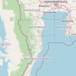
Map view of Ao Siam National Park

Use this park location map to pinpoint Ao Siam National Park in Thailand, understand its exact geographic position, and read its mapped placement within the surrounding landscape more clearly.

Pigeon | © OpenStreetMap contributors

Location context for Ao Siam National Park

Prachuap Khiri Khan Province
Park atlas

Explore the surrounding coastal landscapes and Gulf of Thailand island ecosystems, comparing regional conservation efforts in Prachuap Khiri Khan Province.

Discover Other National Parks and Protected Areas Near Ao Siam National Park
Discover other national parks and protected areas sharing Ao Siam National Park's unique coastal forest and island ecosystems, tracing connected conservation landscapes across the western Gulf of Thailand. Compare diverse protected landscapes within Prachuap Khiri Khan Province and adjacent regions, gaining insight into the broader spread of regional conservation efforts.
National parkPrachuap Khiri Khan Province

Hat Wanakon National Park: Mapped Protected Area within Prachuap Khiri Khan's Geography

Explore protected national park boundaries and regional landscape context.

Hat Wanakon National Park serves as a significant protected landscape entity within the Prachuap Khiri Khan Province region of Thailand. This national park's mapped boundaries offer insight into its territorial extent and its role within the country's network of conservation areas. Exploring this park provides a concrete example of protected land within the varied geography of the Kra Isthmus, enriching your atlas-based understanding of Thailand's natural reserves.

Area
38 km²
Established
1992
IUCN
II
Visitors
43.3K annual
National parkPrachuap Khiri Khan Province

Namtok Huai Yang National Park: Protected Mountain Terrain and Waterfall Atlas

Discover Prachuap Khiri Khan Province's significant natural landscape.

Namtok Huai Yang National Park is a key protected area in Thailand's Prachuap Khiri Khan Province, renowned for its distinctive montane geography shaped by the Tenasserim Hills. This national park offers a detailed view of forest ecosystems, watershed importance, and cascading waterfalls, all presented within a structured atlas framework. Users can explore the park's mapped boundaries and terrain characteristics, gaining a concrete understanding of its geographic significance and natural protected landscape.

Area
161 km²
Established
1991
IUCN
II
Visitors
26.9K annual
National parkPrachuap Khiri Khan Province

Khao Sam Roi Yot National Park: A National Park within Prachuap Khiri Khan Province's Geography

Explore the mapped protected landscape and regional context.

Investigate Khao Sam Roi Yot National Park as a distinct protected area and national park entity within the geographic framework of Prachuap Khiri Khan Province. This dedicated page offers insights into its mapped boundaries, regional landscape character, and its contribution to the atlas of protected lands in western Thailand. Understand the park's environmental geography and its specific place within the broader national conservation efforts.

Area
98 km²
Established
1966
IUCN
II
Visitors
164.7K annual
National parkTanintharyi Region

Lampi Island Marine National Park National Park: Geographic Atlas and Protected Landscape Overview

Discover mapped boundaries and regional park geography.

Lampi Island Marine National Park is a designated national park offering a focused lens on protected landscapes and regional geography. Explore its precise mapped boundaries and understand its place within the Tanintharyi Region's natural terrain. This profile is designed for atlas-based discovery, providing essential geographic context for the park and its role as a conservation area.

Area
204.8 km²
Established
1996
IUCN
II
Relief
Mixed relief
National parkSurat Thani Province

Than Sadet, Ko Pha-ngan National Park: A Royal Heritage Protected Landscape in Surat Thani

Island geography, royal rivers, and mountain terrain exploration.

Delve into Than Sadet, Ko Pha-ngan National Park, a protected area in Surat Thani Province renowned for its fusion of natural beauty and historical significance. This park protects diverse ecosystems, including dense forests, the famous Than Sadet waterfall and river system, and mountainous interiors, culminating in views from Khao Ra. As a key protected landscape, its mapped boundaries reveal a vital natural sanctuary with deep royal connections, inviting exploration of its unique geographic context and heritage within the Thai atlas.

Area
43 km²
Established
2018
IUCN
II
Visitors
158.1K annual
National parkPhetchaburi Province

Kaeng Krachan National Park: Thailand National Park Atlas and Protected Landscape

Mapped boundaries and regional geography of this national park.

Access detailed geographic information for Kaeng Krachan National Park, a protected national park located in Phetchaburi Province, Thailand. Understand its specific landscape context and explore its mapped boundaries within the regional geography. This resource is designed for structured atlas-driven discovery of protected natural areas.

Area
2,915 km²
Established
1981
IUCN
II
Visitors
103.5K annual
National parkSurat Thani Province

Mu Ko Ang Thong National Park: National Park with Distinct Protected Landscape and Geographic Context

Explore mapped boundaries within Surat Thani Province, Thailand.

Mu Ko Ang Thong National Park serves as a key protected area, offering a focused study of its specific geography and landscape features within the broader atlas of Surat Thani Province. As a national park, its mapped boundaries are crucial for understanding conservation landscapes in this part of southern Thailand. Users exploring this destination will find detailed context on its natural terrain and regional geographic placement.

Area
102 km²
Established
1980
IUCN
II
Visitors
134.3K annual
National parkRanong

Laem Son National Park: A Protected National Park in Ranong's Geographic Landscape

Explore the mapped natural terrain and protected area boundaries.

Laem Son National Park is a key protected area within Thailand's Ranong province, offering valuable insights into regional geography and landscape preservation. This entry focuses on its status as a national park, providing a structured view of its protected boundaries and environmental context. Understand its unique position within the mapped geography, vital for any comprehensive atlas exploration of protected lands in the region.

Area
315 km²
Established
1983
IUCN
II
Visitors
21.9K annual

Common questions about visiting, size, designation, and location context for Ao Siam National Park

Ao Siam National Park FAQs for park facts, access, geography, and protected area context
Find quick answers about Ao Siam National Park, including protected-area facts, park geography, trail and visitor context, and how the park fits into its surrounding country and regional landscape.
MoriAtlas Explorer

Continue Your Protected Areas Search Across the Global Atlas

Deepen your exploration by continuing the structured search for national parks and protected areas worldwide. Utilize the comprehensive filtering capabilities to compare different conservation landscapes and refine your understanding of global park geography. Discover more about the distribution and characteristics of protected natural areas.

Global natural geography