

Mori Atlas logo
National parkHat Wanakon National Park

Discover the geographic context and protected boundaries of this Thai National Park.

Hat Wanakon National Park: A Mapped Protected Landscape in Prachuap Khiri Khan Province

Hat Wanakon National Park stands as a key protected area within Thailand's Prachuap Khiri Khan Province, offering a distinct chapter in the nation's atlas of natural reserves. This national park provides a crucial geographic anchor, showcasing a segment of the region's landscape that is preserved for its ecological and territorial significance. Users can explore its mapped boundaries and understand its position within the broader coastal geography of the Kra Isthmus, making it a valuable point of reference for geographic discovery.

Marine national parkCoral reefBeachGulf of ThailandCoastal parkIslands

Hat Wanakon National Park

National park

Park overview

Structured park overview, official facts, and landscape profile for Hat Wanakon National Park

Hat Wanakon National Park park facts, protected area profile, and essential visitor context
Review the core facts for Hat Wanakon National Park, including designation, size, terrain, visitor scale, habitats, and operating context in one park-focused overview.

About Hat Wanakon National Park

Hat Wanakon National Park represents a significant coastal and marine protected area in western Thailand, positioned along the Gulf of Thailand in Prachuap Khiri Khan Province. The park was officially designated on December 30, 1992, becoming Thailand's 76th national park and the 18th marine national park in the country. The protected area spans approximately 38 square kilometers, encompassing both terrestrial and marine environments across the Mueang Prachuap Khiri Khan and Thap Sakae districts. The park's coastal location along Petchkasem Road makes it accessible to visitors traveling from Bangkok, approximately 300 kilometers to the north, with the beachfront situated about 23 kilometers from Prachuap Khiri Khan town center. The park's dual identity as both a beach destination and marine sanctuary sets it apart, offering visitors the opportunity to experience both coastal scenery and underwater exploration within a single protected area.

Quick facts and research context for Hat Wanakon National Park

Hat Wanakon National Park occupies 38 square kilometers along the Gulf of Thailand coast in Prachuap Khiri Khan Province. The park was established in 1992 and is managed by Thailand's Department of National Parks, Wildlife and Plant Conservation. The protected area encompasses both coastal terrain and marine environments, including the twin islands of Ko Chan and Ko Tai-si. The surrounding coral reef system is recognized as the most abundant in the Gulf of Thailand, supporting numerous coral species and marine creatures within an area stretching approximately two kilometers with depths between 8 and 10 meters. The park receives approximately 43,000 visitors annually, drawing both beach-goers and snorkeling enthusiasts.

Park context

Deeper park guide and search-rich context for Hat Wanakon National Park

Hat Wanakon National Park history, landscape, wildlife, and travel context
Explore Hat Wanakon National Park through its history, landscape character, ecosystems, wildlife, conservation priorities, cultural context, and seasonal travel timing in a structured park guide built for atlas discovery and search intent.

Why Hat Wanakon National Park stands out

Hat Wanakon National Park is best known for its exceptional coral reef ecosystem, which is considered the most abundant in the Gulf of Thailand. The reef surrounds the twin islands of Ko Chan and Ko Tai-si, located about seven kilometers offshore, and supports a remarkable diversity of hard corals, soft corals, and marine species including the rare Acropora cytherea. The park's namesake beach offers a relatively pristine sandy coastline along Petchkasem Road, while the inland areas feature sparse woodland dominated by species such as Indian thorny bamboo, Burmese rosewood, crape myrtle, Queen's flower, and teak. The combination of accessible beach recreation and outstanding underwater marine life makes this park distinctive among Thailand's coastal protected areas.

Hat Wanakon National Park history and protected-area timeline

Hat Wanakon National Park originated as a forest park before its elevation to national park status in 1992. Prior to formal protection, the area existed as part of the Wang Duean and Huai Yang national reserved forests, with the region containing the Huai Yang forest park, Huai Yang arboretum, and Huai Yang forestry station within what is now the Mueang Prachuap Khiri Khan district portion of the park. The Huai Yang forestry station was discontinued as part of the transition toward establishing the national park, with the Department of Forest Management transferring administrative oversight to the National Parks Division beginning in the 1989 fiscal year. This designation as the 76th national park and 18th marine national park in Thailand reflected the country's growing commitment to protecting coastal and marine ecosystems alongside terrestrial forest environments.

Hat Wanakon National Park landscape and geographic character

The terrain of Hat Wanakon National Park consists primarily of coastal plain and elevated coastal landscape, with average elevations ranging from sea level to approximately five meters above mean sea level. The land area features a gradual slope from the western side toward the eastern coastline, creating a slightly more pronounced incline on the western side compared to the eastern sections. The park's two offshore islands, Ko Chan and Ko Tai-si, are connected to each other and feature geology characterized by igneous rock and sandstone formations. Both islands support short stretches of sandy beach, with the sand consisting predominantly of fine coral fragments. The beach area along the mainland coast offers a more continuous sandy shoreline suitable for recreational visitors.

Hat Wanakon National Park ecosystems, habitats, and plant life

The nature of Hat Wanakon National Park encompasses both terrestrial and marine ecosystems characteristic of Thailand's Gulf coast. The terrestrial vegetation consists of sparse woodland containing various plant species including Indian thorny bamboo, Burmese rosewood, crape myrtle, Queen's flower, and teak trees. The marine environment constitutes the park's most ecologically significant feature, with the coral reef system surrounding the twin islands representing the most abundant coral reef in the Gulf of Thailand. This reef supports extensive populations of hard corals, soft corals, and diverse marine organisms across an area spanning approximately two kilometers in width at depths between 8 and 10 meters. The reef ecosystem provides critical habitat for numerous marine species, with the rare coral species Acropora cytherea documented within the protected waters.

Hat Wanakon National Park wildlife and species highlights

The wildlife of Hat Wanakon National Park centers on its exceptional marine biodiversity. The coral reef ecosystem surrounding Ko Chan and Ko Tai-si islands supports hundreds of coral species and countless reef-associated fish and invertebrates. The rare coral species Acropora cytherea is specifically noted as occurring within the park's protected marine waters. The reef area is closed to fishing boat access, which helps maintain the ecological integrity of the marine community and protects the diverse organisms that depend on this habitat. While the terrestrial wildlife component receives less documentation in available sources, the woodland areas support various bird species and smaller fauna typical of coastal forest habitats in the region.

Hat Wanakon National Park conservation status and protection priorities

Hat Wanakon National Park holds significant conservation value as a marine protected area, particularly for its coral reef ecosystem. The reef surrounding the twin islands is recognized as the most abundant in the Gulf of Thailand, making it a priority area for coral conservation in the country. The designation as Thailand's 18th marine national park reflects the specific importance placed on protecting marine environments alongside terrestrial areas. The park implements restrictions on fishing boat access within the reef area, which helps reduce direct human impacts on the coral community. The presence of the rare species Acropora cytherea further underscores the conservation significance of this marine environment.

Hat Wanakon National Park cultural meaning and human context

Hat Wanakon National Park exists within the cultural and administrative context of Prachuap Khiri Khan Province, a coastal region in western Thailand. The park overlaps two districts, Mueang Prachuap Khiri Khan and Thap Sakae, reflecting the administrative organization of the province. The Thai name of the park, อุทยานแห่งชาติหาดวนกร, directly translates to indicate its identity as a national park centered on the Wanakon beach area. The region's proximity to Bangkok and the main transportation corridor of Petchkasem Road has influenced access patterns, though the park remains less developed than some other Thai coastal destinations.

Top sights and standout views in Hat Wanakon National Park

The highlights of Hat Wanakon National Park include the pristine Wanakon Beach along the mainland coastline, accessible directly from Petchkasem Road. The twin islands of Ko Chan and Ko Tai-si, situated approximately seven kilometers offshore, represent the marine centerpiece of the park and offer exceptional snorkeling and diving opportunities around their abundant coral reefs. The reef system, noted as the most extensive in the Gulf of Thailand, provides visitors with encounters with diverse coral species and marine life. The combination of above-water beach recreation and below-water marine exploration within a single protected area creates a distinctive visitor experience. The relatively uncrowded nature of the beach compared to more famous Thai coastal destinations adds to its appeal for those seeking a more natural coastal experience.

Best time to visit Hat Wanakon National Park

The best time to visit Hat Wanakon National Park aligns with Thailand's general climatic patterns, with the cool dry season from December through February offering the most comfortable conditions for beach activities. The park experiences a tropical monsoon climate with a distinct wet season from May through November, during which rainfall is more frequent though often occurring in concentrated showers. Average temperatures throughout the year hover around 27.7 degrees Celsius, with May typically being the warmest month and January the coolest. October represents the wettest period with the highest rainfall, while December is the driest month. Visitors seeking optimal beach and marine conditions should consider the dry season months, though the reef environment is accessible year-round for those willing to encounter occasional rainfall.

Park location guide

Geography guide, regional context, and park location map for Hat Wanakon National Park

Hat Wanakon National Park park geography, regions, and map view in Thailand
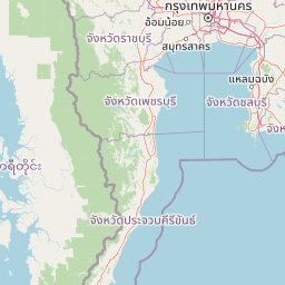
Understand where Hat Wanakon National Park sits in Thailand through a broader geographic reading of the surrounding landscape, nearby location context, and its mapped position within the national park landscape.

How Hat Wanakon National Park fits into Thailand

Thailand is a Southeast Asian nation formerly called Siam, located in mainland Southeast Asia. It operates as a unitary parliamentary constitutional monarchy under King Vajiralongkorn. The country borders Myanmar, Laos, Cambodia, and Malaysia, with maritime boundaries involving Vietnam, Indonesia, and India. Thailand has a population of nearly 66 million and covers approximately 513,120 km². Historically, the Sukhothai Kingdom marks the beginning of Thai history, followed by the powerful Ayutthaya Kingdom.

Wider geography shaping Hat Wanakon National Park in Thailand

Thailand occupies mainland Southeast Asia with borders to Myanmar (west/northwest), Laos (east/northeast), Cambodia (southeast), and Malaysia (south). The country has coastline along the Gulf of Thailand to the southeast and the Andaman Sea to the southwest. The territory covers approximately 513,120 km².

Map view of Hat Wanakon National Park

Use this park location map to pinpoint Hat Wanakon National Park in Thailand, understand its exact geographic position, and read its mapped placement within the surrounding landscape more clearly.

Pigeon | © OpenStreetMap contributors

Location context for Hat Wanakon National Park

Prachuap Khiri Khan Province
Park atlas

Compare marine and coastal protected areas, mapping the Gulf of Thailand's diverse conservation landscapes.

Discover Other National Parks Near Hat Wanakon National Park in Coastal Thailand
Continue your exploration from Hat Wanakon National Park by browsing other marine national parks and protected coastal landscapes along Thailand's Gulf, mapping their distinct characteristics. Compare diverse park geographies, from sandy beaches to offshore coral reefs, and understand regional conservation efforts within their broader context.
National parkPrachuap Khiri Khan Province

Namtok Huai Yang National Park: Protected Mountain Terrain and Waterfall Atlas

Discover Prachuap Khiri Khan Province's significant natural landscape.

Namtok Huai Yang National Park is a key protected area in Thailand's Prachuap Khiri Khan Province, renowned for its distinctive montane geography shaped by the Tenasserim Hills. This national park offers a detailed view of forest ecosystems, watershed importance, and cascading waterfalls, all presented within a structured atlas framework. Users can explore the park's mapped boundaries and terrain characteristics, gaining a concrete understanding of its geographic significance and natural protected landscape.

Area
161 km²
Established
1991
IUCN
II
Visitors
26.9K annual
National parkPrachuap Khiri Khan Province

Ao Siam National Park: Protected Landscape and Regional Geography within Thailand

Discover the mapped boundaries and natural terrain of this Thai national park.

Ao Siam National Park is a designated national park in Thailand, located within the Prachuap Khiri Khan Province. This protected landscape offers valuable insights into the regional geography of the Kra Isthmus. Users can explore its mapped boundaries and understand its significance as a natural area within the atlas of Thai protected lands. The park's setting provides a concrete example of protected territory contributing to the region's overall geographic context.

Area
31.94 km²
IUCN
II
Relief
Lowland
Climate
Subtropical
National parkPrachuap Khiri Khan Province

Khao Sam Roi Yot National Park: A National Park within Prachuap Khiri Khan Province's Geography

Explore the mapped protected landscape and regional context.

Investigate Khao Sam Roi Yot National Park as a distinct protected area and national park entity within the geographic framework of Prachuap Khiri Khan Province. This dedicated page offers insights into its mapped boundaries, regional landscape character, and its contribution to the atlas of protected lands in western Thailand. Understand the park's environmental geography and its specific place within the broader national conservation efforts.

Area
98 km²
Established
1966
IUCN
II
Visitors
164.7K annual
National parkPhetchaburi Province

Kaeng Krachan National Park: Thailand National Park Atlas and Protected Landscape

Mapped boundaries and regional geography of this national park.

Access detailed geographic information for Kaeng Krachan National Park, a protected national park located in Phetchaburi Province, Thailand. Understand its specific landscape context and explore its mapped boundaries within the regional geography. This resource is designed for structured atlas-driven discovery of protected natural areas.

Area
2,915 km²
Established
1981
IUCN
II
Visitors
103.5K annual
National parkTanintharyi Region

Lampi Island Marine National Park National Park: Geographic Atlas and Protected Landscape Overview

Discover mapped boundaries and regional park geography.

Lampi Island Marine National Park is a designated national park offering a focused lens on protected landscapes and regional geography. Explore its precise mapped boundaries and understand its place within the Tanintharyi Region's natural terrain. This profile is designed for atlas-based discovery, providing essential geographic context for the park and its role as a conservation area.

Area
204.8 km²
Established
1996
IUCN
II
Relief
Mixed relief
National parkRatchaburi Province

Chaloem Phrakiat Thai Prachan National Park: Protected Landscape Identity and Geographic Atlas Context

Mapped park boundaries and regional natural terrain discovery.

Chaloem Phrakiat Thai Prachan National Park serves as a key national park entity for structured geographic discovery. This page focuses on its protected landscape, mapped boundaries, and integration within the natural geography of Ratchaburi Province. Explore the park's specific atlas contribution and its place within regional conservation land patterns, providing a factual foundation for landscape context.

Area
328.05 km²
Established
2012
IUCN
II
Climate
Tropical
National parkSurat Thani Province

Than Sadet, Ko Pha-ngan National Park: A Royal Heritage Protected Landscape in Surat Thani

Island geography, royal rivers, and mountain terrain exploration.

Delve into Than Sadet, Ko Pha-ngan National Park, a protected area in Surat Thani Province renowned for its fusion of natural beauty and historical significance. This park protects diverse ecosystems, including dense forests, the famous Than Sadet waterfall and river system, and mountainous interiors, culminating in views from Khao Ra. As a key protected landscape, its mapped boundaries reveal a vital natural sanctuary with deep royal connections, inviting exploration of its unique geographic context and heritage within the Thai atlas.

Area
43 km²
Established
2018
IUCN
II
Visitors
158.1K annual
Watercolor painting showing green hills, purple mountains, and a calm water body with sparse vegetation
National parkRayong Province

Khao Laem Ya, Mu Ko Samet National Park: Marine National Park and Protected Island Geography

Coastal terrain and archipelago mapped within Rayong Province.

Delve into Khao Laem Ya, Mu Ko Samet National Park, a significant marine protected area located in Rayong Province, Thailand. This atlas entry highlights the park's archipelago of islands, including Ko Samet, its mainland coastal features like Khao Laem Ya, and the surrounding Gulf of Thailand waters. Understand the park's role in coastal conservation, its mapped marine environments, and its unique blend of terrestrial and aquatic protected landscapes for geographic discovery.

Area
131 km²
Established
1981
IUCN
II
Visitors
1.6M annual

Common questions about visiting, size, designation, and location context for Hat Wanakon National Park

Hat Wanakon National Park FAQs for park facts, access, geography, and protected area context
Find quick answers about Hat Wanakon National Park, including protected-area facts, park geography, trail and visitor context, and how the park fits into its surrounding country and regional landscape.
MoriAtlas Explorer

Continue Your Protected Areas Search Across the Global Atlas

Deepen your exploration by continuing the structured search for national parks and protected areas worldwide. Utilize the comprehensive filtering capabilities to compare different conservation landscapes and refine your understanding of global park geography. Discover more about the distribution and characteristics of protected natural areas.

Global natural geography