Mori Atlas logo
Protected landscapeApuseni Natural Park

Map the boundaries and understand the landscape setting of this significant protected area.

Apuseni Natural Park: Protected Landscape Atlas and Geographic Context for Discovery

(Parcul Natural Apuseni)

Delve into the protected landscape of Apuseni Natural Park, a key entity within Romania's conservation network. MoriAtlas provides a structured view of this natural area, focusing on its geographic footprint and mapped boundaries. Understand its place in the regional geography and explore the unique characteristics of its protected landscape for atlas-based discovery.

karst landscapecave systemsWestern Carpathiansmountain nature parkkarst plateausice caves
Stylized illustration of a river flowing through a canyon landscape with mountains in the background and pine trees in the foreground

Apuseni Natural Park

Protected landscape

Park overview

Structured park overview, official facts, and landscape profile for Apuseni Natural Park

Apuseni Natural Park park facts, protected area profile, and essential visitor context
Review the core facts for Apuseni Natural Park, including designation, size, terrain, visitor scale, habitats, and operating context in one park-focused overview.

About Apuseni Natural Park

Apuseni Natural Park represents one of Romania's most significant protected landscapes, spanning the rugged terrain of the Apuseni Mountains in the western part of the country. The park encompasses parts of three counties, with Bihor County holding the largest share at 32 percent, followed by Cluj at 40 percent and Alba at 28 percent. The territory includes 16 communes with 53 localities fully within the park boundaries and an additional eight partially included. The protected area was designated through Romanian legislation, with initial establishment in 1990 and formal protected status confirmed through Law Number 5 of March 6, 2000. The park's significance extends beyond its borders as part of the Western Carpathians, a mountain system that forms a distinct biogeographical unit within Europe. The Apuseni Mountains, while lower in elevation than the Southern Carpathians, contain remarkable ecological and geological diversity that has earned the region recognition as a destination of excellence by the European Commission through the EDEN program in 2009. The landscape is characterized by a mosaic of forests, grasslands, and rocky terrain that has shaped both the natural environment and the human communities that have inhabited these valleys for centuries.

Quick facts and research context for Apuseni Natural Park

Apuseni Natural Park extends across Alba, Bihor, and Cluj counties in western Romania, protecting 75,784 hectares of mountainous terrain within the Apuseni Mountains. The nearest urban center is Huedin. The park features three tourism resorts at Boga, Fântânele, and Vârtop. The area encompasses more than 30 natural reserves including significant caves such as Scărișoara Cave and Bears' Cave, karst plateaus like Padiș and Lumea Pierdută, and geological formations including the Pietrele Galbenei and Cârligați Peak. The Beliș-Fântânele reservoir in the northern part of the park covers 826 hectares at an elevation of 1,050 meters.

Park context

Deeper park guide and search-rich context for Apuseni Natural Park

Apuseni Natural Park history, landscape, wildlife, and travel context
Explore Apuseni Natural Park through its history, landscape character, ecosystems, wildlife, conservation priorities, cultural context, and seasonal travel timing in a structured park guide built for atlas discovery and search intent.

Why Apuseni Natural Park stands out

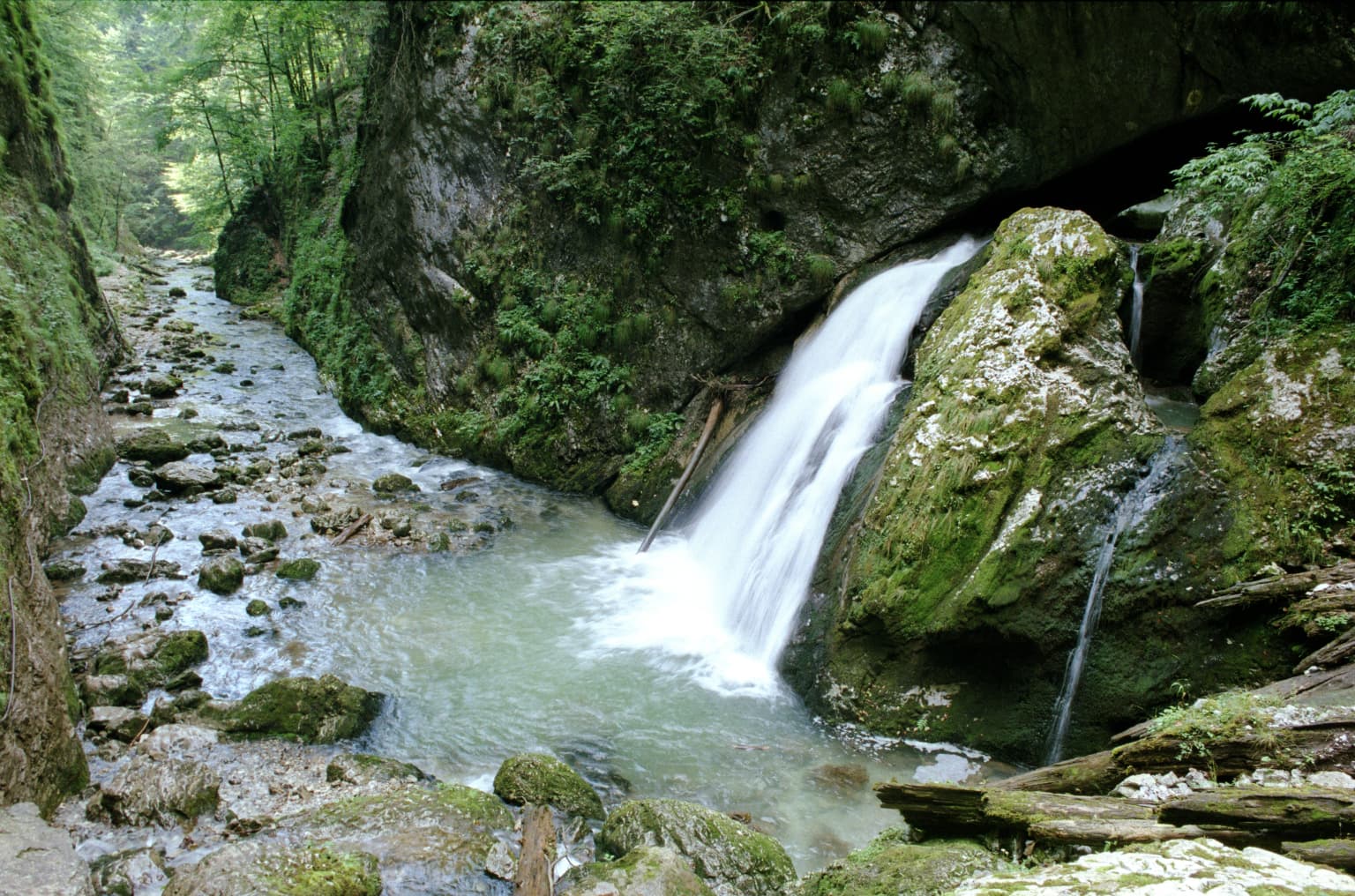
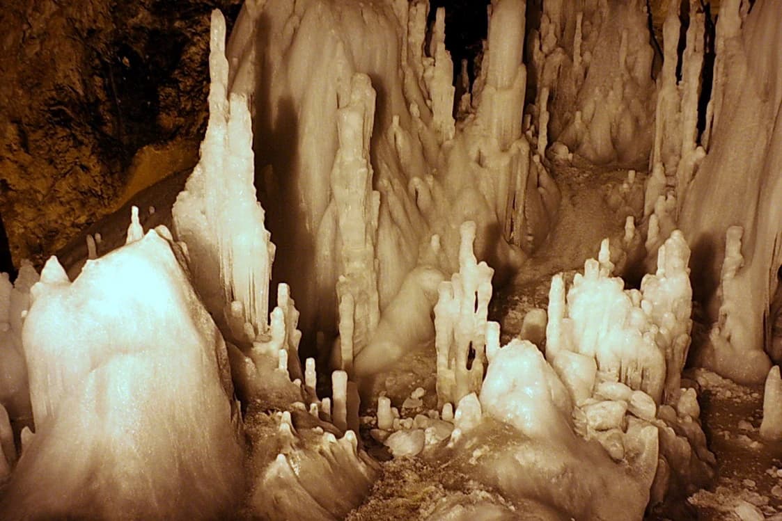
Apuseni Natural Park is renowned for its exceptional karst landscape, featuring one of Romania's most extensive underground cave networks. The park contains the famous Scărișoara Cave, one of the largest ice caves in southeastern Europe, along with the Bears' Cave with its paleontological deposits. The Padiș karst plateau represents a highlight with its dramatic limestone formations, sinkholes, and underground rivers. The region is also celebrated for its traditional wooden churches, particularly those in Arieșeni, Gârda de Sus, and Saca, which are listed as historical monuments. The combination of pristine karst geology, biological diversity, and cultural heritage makes this park distinctive within Romania's protected areas.

Snow-covered mountain ridge with evergreen trees under clear blue sky
Snow-covered mountain ridge with evergreen trees under a clear blue sky in Apuseni Natural Park

Apuseni Natural Park history and protected-area timeline

The protection of Apuseni's natural heritage reflects a longer tradition of nature conservation awareness in Romania that emerged in the early twentieth century. In 1928, the first Congress of Naturalists in Romania took place in Cluj Napoca, where the prominent explorer and biologist Emil Racoviță proposed the development of nature protection legislation. This initiative led to the establishment of Romania's first national park at Retezat in 1935, and by the beginning of 1990, the country had expanded to 13 protected areas. Apuseni Natural Park was created through Order of the Ministry of Agriculture from January 27, 1990, which established natural parks under the direct management of forestry units. The protected status was confirmed through Law Number 5 from March 6, 2000, which approved the national territorial planning section for protected zones. In 2003, Government Decision 230 restored and clarified the park's boundaries and total area. The park received international recognition in 2009 when it was awarded at the EDEN Gala in Brussels as an excellent tourist destination, subsequently featured on the European Destinations of Excellence website with a promotional video produced by the European Commission.

Apuseni Natural Park landscape and geographic character

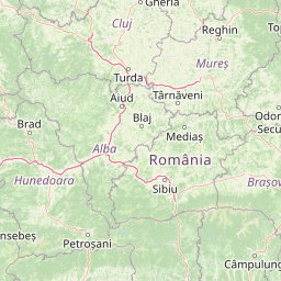
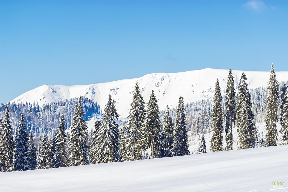
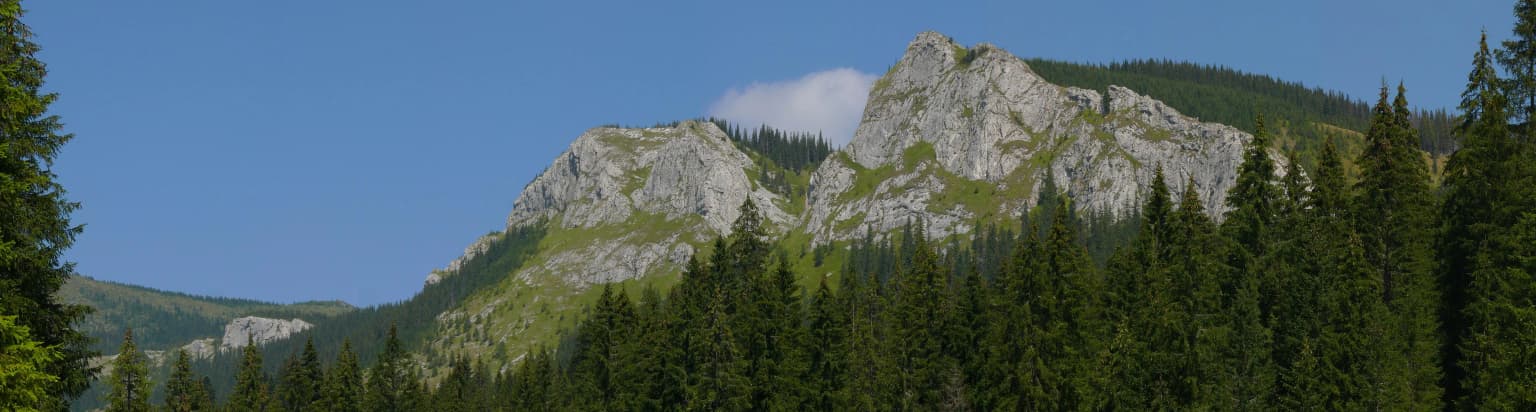
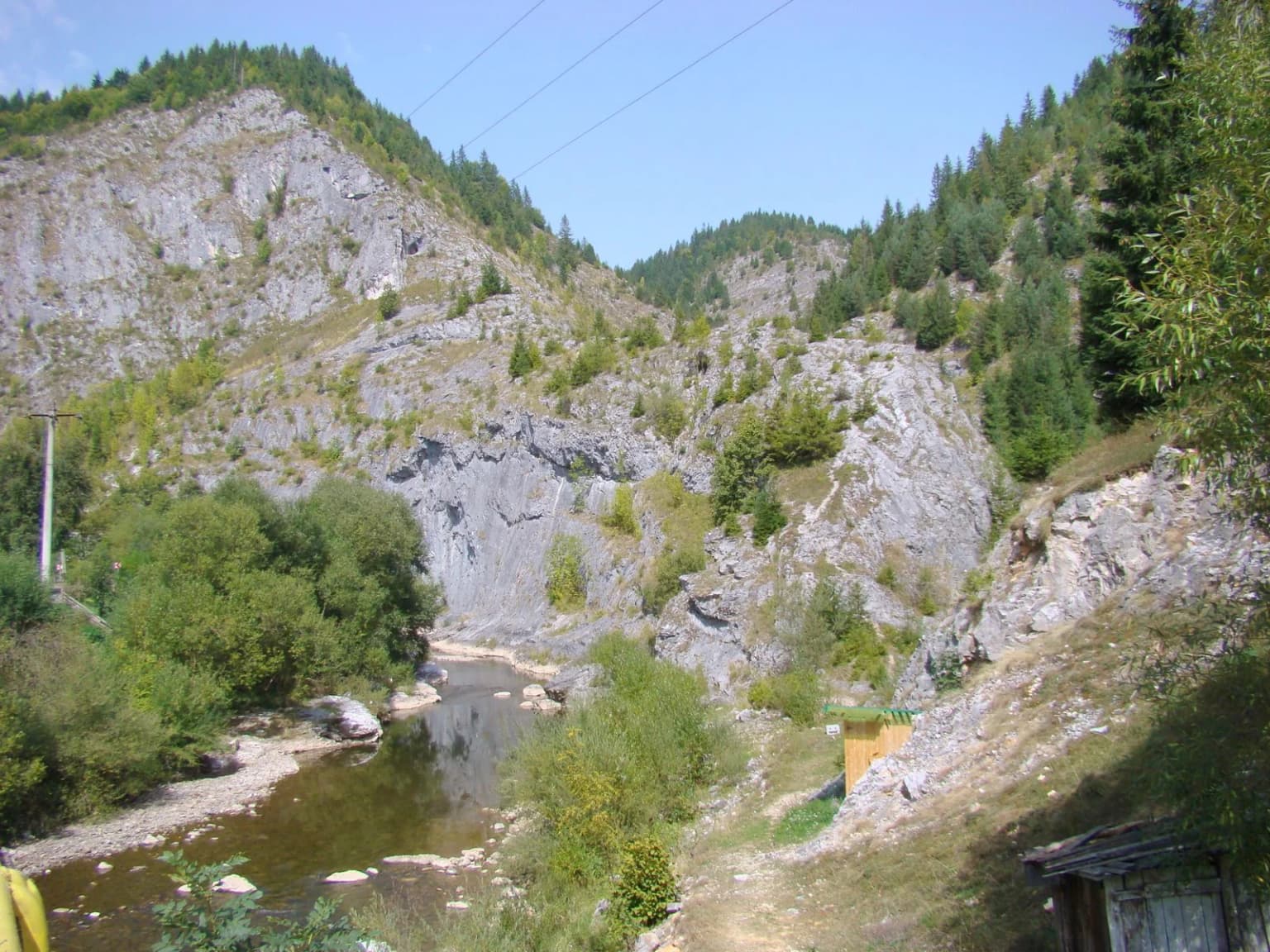
The physical landscape of Apuseni Natural Park displays remarkable geological complexity and variety of landforms. The Apuseni Mountains consist of several distinct massifs including the Bihor Mountains to the south, the Vlădeasa Mountains to the north, the Gilău Mountains in the east, the Pădurea Craiului Mountains to the northwest, and the Codru-Moma Mountains to the southwest. Geological formations include crystalline schists in the Biharia and Vlădeasa massifs, limestone sequences interbedded with conglomerates and sandstones in the Bihor Mountains, and Triassic, Cretaceous, and Jurassic limestone in the Pădurea Craiului range. The park contains extensive karst terrain characterized by sinkholes, underground caves, caves, and disappearing streams. Notable landscape features include the Padiș and Lumea Pierdută karst plateaus, dramatic gorges such as Cheile Galbenei and Valea Sighiștelului, and rock formations like Pietrele Galbenei and Cârligați Peak. The highest point within the reserve is Vârful Biserica Moțului in the Bihor Mountains. The Beliș-Fântânele reservoir, created between 1970 and 1974, forms a significant artificial lake in the northern sector of the park.

Mountainous landscape with rocky peaks, dense pine forest, and clear blue sky
Panoramic view of rocky mountain peaks and coniferous forest in Apuseni Natural Park

Apuseni Natural Park ecosystems, habitats, and plant life

The ecological character of Apuseni Natural Park reflects its position within the Western Carpathians, encompassing diverse habitats ranging from valley floors to alpine zones. Forest cover includes both coniferous and deciduous species, with spruce and fir dominating higher elevations while beech, oak, and hornbeam occupy lower slopes and valleys. The park contains dacic beech forests, oak-hornbeam woodlands, relict forests, and floodplain forests along watercourses. Non-forested habitats include alpine and boreal shrublands, dry heath communities, alpine and boreal grasslands, and Pannonian rocky grasslands. Peatlands and wetlands occur in several valley locations, supporting specialized plant communities. The vegetation zonation reflects the transition between Carpathian and Pannonian biogeographical influences, creating a mosaic of habitats that supports considerable biodiversity. The park lies at the intersection of different climatic influences, with continental-moderate conditions generally characterized by moist and cool conditions at higher elevations and warmer conditions in lower valleys.

A lake surrounded by forested mountains under a clear blue sky with two people sitting on the grassy shore
Beliș-Fântânele Lake in Apuseni Natural Park with two people sitting on the grassy shore

Apuseni Natural Park wildlife and species highlights

The fauna of Apuseni Natural Park includes species characteristic of Carpathian forests and mountain environments. Large mammals include red deer, roe deer, wild boar, and the distinctive chamois inhabiting rocky terrain. Predators include brown bear, wolf, lynx, and wildcat, with smaller predators such as pine marten, polecat, and weasel present throughout the forested areas. The park supports notable bird species including capercaillie in coniferous forest habitats and golden eagle nesting on rocky cliffs. Other bird species include the Hazel Grouse, small spotted eagle, raven, and various tit species. Cave-dwelling species inhabit the numerous underground systems, while stream environments support trout and other cold-water fish. Several species present in the park are protected under European legislation through the Habitats Directive, reflecting the site's importance for biodiversity conservation within the Carpathian region.

A waterfall cascading over moss-covered rocks into a river in a forested gorge
Waterfall in Cheile Galbenei gorge, Apuseni Natural Park

Apuseni Natural Park conservation status and protection priorities

Apuseni Natural Park functions as a Category V protected landscape under IUCN classification, recognizing its value in conserving both natural ecosystems and the cultural landscapes shaped by traditional human activities. The park incorporates more than 30 specific natural reserves protecting geological, floristic, faunistic, speleological, and landscape values. Notable reserves include the Scărișoara Cave with its permanent ice formations, the Bears' Cave with significant paleontological deposits, and the extensive karst systems of Padiș and Lumea Pierdută. The management framework involves Romsilva, the national forestry authority, with the Apuseni Natural Park Administration responsible for site management. The designation as an EDEN destination in 2009 recognized the park's sustainable tourism practices and cultural heritage value. Conservation challenges include balancing human use with ecological protection, managing forest resources, and addressing issues related to illegal logging that have been reported in adjacent areas.

Apuseni Natural Park cultural meaning and human context

The Apuseni Mountains have been inhabited for centuries by rural communities whose traditional practices have shaped the landscape. The park territory encompasses villages where agriculture, particularly sheep husbandry and transhumance, has influenced the open grasslands and pastures. Several wooden churches within the park are listed as historical monuments, including the Church of the Ascension in Arieșeni from 1791, the Church of Saint George in Saca from the eighteenth century, the Church in Brădet from 1733, and the Church of the Nativity of Saint John the Baptist in Gârda de Sus from 1792. The region is associated with the historical uprising of 1784, when peasants led by Horea, Cloșca, and Crișan revolted against feudal obligations. The memorial house of Cloșca in Cărpiniș commemorates this significant moment in Romanian history. Traditional architecture and cultural practices remain visible in the villages scattered throughout the park, creating a cultural landscape that complements the natural values.

Interior view of a cave with prominent ice stalactites and stalagmites in a cavernous space
Interior of Scarisoara Cave featuring large ice formations in a cavernous space

Top sights and standout views in Apuseni Natural Park

Apuseni Natural Park offers visitors exceptional karst landscapes with extensive cave systems, dramatic gorges, and unique geological formations. The Scărișoara Cave ranks among Romania's most impressive ice caves, while the Bears' Cave contains significant paleontological remains. The Padiș karst plateau provides spectacular scenery with its limestone pavements and underground rivers. Traditional wooden churches scattered throughout the valleys represent valuable cultural heritage. The Beliș-Fântânele reservoir offers recreational opportunities in a mountain setting. The park's position within the Apuseni Mountains, a range known for its relatively accessible terrain compared to higher Carpathian massifs, makes it a destination for hiking, caving, and nature observation throughout the year.

River flowing through a mountain valley with rocky cliffs, forested slopes, and a small structure on the right side
Arieșul Mare river flowing through rocky terrain in Apuseni Natural Park near Scărișoara, Romania

Best time to visit Apuseni Natural Park

The Apuseni Natural Park can be visited throughout the year, with each season offering distinct experiences. Summer months bring warm conditions ideal for hiking, cave exploration, and enjoying mountain meadows in full bloom. The karst plateaus and gorges are most accessible during the drier summer period. Autumn offers colorful forest scenery as deciduous species change color, along with potentially fewer visitors. Winter reveals the park's karst landscape under snow, though some areas may be difficult to access. The ice cave at Scărișoara maintains sub-zero temperatures year-round, making it a feature of particular interest in warmer months when contrast with surface conditions is most striking. Spring brings renewed vegetation and increased water flow in streams and waterfalls, though some trails may remain wet. The continental-moderate climate means precipitation occurs throughout the year, with higher amounts in the Bihor Mountains compared to lower valleys.

Park location guide

Geography guide, regional context, and park location map for Apuseni Natural Park

Apuseni Natural Park park geography, regions, and map view in Romania
Understand where Apuseni Natural Park sits in Romania through a broader geographic reading of the surrounding landscape, nearby location context, and its mapped position within the national park landscape.

How Apuseni Natural Park fits into Romania

Romania is a unitary semi-presidential republic located in Southeast and Central Europe. It borders Ukraine, Hungary, Serbia, Bulgaria, Moldova, and the Black Sea. The country has a population of approximately 19 million and covers an area of 238,397 km². Bucharest is the capital and largest city. Romania joined the European Union in 2007.

Wider geography shaping Apuseni Natural Park in Romania

Romania lies on the lower course of the Danube River, north of the Balkan Peninsula, and on the northwestern shore of the Black Sea. The terrain is varied, featuring the Carpathian Mountains in the center, the Transylvanian Plateau, the Moldavian Plateau, and plains along the Danube and in the south. The country has a diverse landscape that includes forests, meadows, and wetland areas.

Map view of Apuseni Natural Park

Use this park location map to pinpoint Apuseni Natural Park in Romania, understand its exact geographic position, and read its mapped placement within the surrounding landscape more clearly.

Pigeon | © OpenStreetMap contributors

Location context for Apuseni Natural Park

Alba CountyBihor CountyCluj County

Visual Guide to Apuseni's Protected Landscapes, Diverse Habitats, and Distinctive Karst Terrain

Apuseni Natural Park Photos: Explore Karst Landscapes, Caves, and Mountain Scenery in Romania
Explore the distinctive landscapes of Apuseni Natural Park through a curated collection of imagery, revealing its dramatic karst formations, extensive cave systems, and verdant mountain scenery. Visually understand the park's protected status, diverse habitats, and regional character, offering a crucial perspective on its geological wonders and ecological richness within the Western Carpathians of Romania.

Snow-covered mountain ridge with evergreen trees under clear blue sky

Steep rocky cliff face with exposed earth layers in shades of brown, red, and beige, interspersed with patches of green vegetation, set against forested hills under a partly cloudy sky

Mountainous landscape with rocky peaks, dense pine forest, and clear blue sky

A lake surrounded by forested mountains under a clear blue sky with two people sitting on the grassy shore

A waterfall cascading over moss-covered rocks into a river in a forested gorge

A serene lake surrounded by grassy hills and coniferous forests under a partly cloudy sky.

Interior view of a cave with prominent ice stalactites and stalagmites in a cavernous space

River flowing through a mountain valley with rocky cliffs, forested slopes, and a small structure on the right side

Rocky cliff with dense forest and mountain valleys under a clear sky

Tall trees with golden and brown autumn leaves covering the ground in a dense forest

Map of Apuseni Natural Park in Romania displaying various regions including Bihor, Cluj, Alba, and Arad counties with labeled mountain ranges in green

Panoramic landscape of green rolling hills with scattered hay bales, a small building, forested slopes, and mountains in the background under a partly cloudy sky

Grassy hillside with scattered trees and a forested ridge under a partly cloudy sky

Male Western Capercaillie bird with dark plumage and fanned tail feathers standing on forest ground with dry leaves.

Dark cave entrance with rocky walls and moss leading to a sunlit forest with tall trees and green vegetation

Rocky cave entrance with moss-covered walls and a gravel path leading into dark interior, surrounded by green vegetation

Park atlas

Compare protected landscapes and regional park geography around Apuseni Natural Park within the Western Carpathians.

Explore Other National Parks and Protected Areas Near Apuseni Natural Park
Browse a curated selection of national parks and protected landscapes that share geographical context or ecological characteristics with Apuseni Natural Park. Expand your atlas-based exploration to compare diverse karst terrain, mountain ecosystems, and conservation efforts across the wider Apuseni Mountains region and beyond.
Watercolor painting of a wetland with a calm lake, reeds, and distant forested hills
Protected landscapeBihor County

Cefa Natural Park Protected Landscape: Atlas and Geographic Context

Mapped wetland habitats and European bird migration routes.

Cefa Natural Park, designated as a protected landscape in Bihor County, Romania, offers significant insight into European wetland ecosystems and migratory bird patterns. Spanning 5,002 hectares, it features critical habitats such as marshes, floodplains, and the Rădvani Forest, positioned directly on the Pannonian, Bulgarian migration corridor. This park is a landmark for understanding regional geography and conservation efforts focused on migratory waterfowl and specialized halophytic vegetation. MoriAtlas provides the structured geographic data and mapped context necessary for detailed atlas-based discovery of this important protected area.

Area
50.02 km²
Established
2010
IUCN
V
Relief
Lowland
Protected landscapeHunedoara County

Grădiștea Muncelului-Cioclovina Natural Park: Protected Landscape in Hunedoara County Atlas

Explore protected area geography and mapped boundaries.

Gain a structured understanding of Grădiștea Muncelului-Cioclovina Natural Park, a significant protected landscape located in Romania's Hunedoara County. This resource details its geographic position and mapped protected area extent, providing essential context for atlas exploration and regional landscape analysis. It serves as a focused entry point for understanding the park's unique geographic identity within its natural setting.

Area
381.84 km²
Established
2000
IUCN
V
Relief
Mountain
Watercolor illustration of a river flowing through a valley with mountains in the background
National parkBékés County

Körös-Maros National Park: National Park Identity and Békés County Landscape Context

Explore its mapped protected areas, wetlands, and steppe grasslands.

Körös-Maros National Park is a designated national park located in Békés County, Hungary, recognized for its expansive wetland ecosystems and steppe grassland habitats. This protected area plays a critical role in the geography of the Southern Great Plain, serving as a vital migration corridor for diverse bird populations. Users can explore the park's distinct landscape features, mapped protected boundaries, and its significance as a hub for avian conservation.

Area
501.34 km²
Established
1997
Relief
Lowland
Climate
Temperate
Protected landscapeSibiu County

Dumbrava Sibiului Natural Park: Protected Landscape Atlas and Geographic Discovery

Explore the mapped natural terrain and regional context.

Dumbrava Sibiului Natural Park is a designated protected landscape offering a unique lens into Romania's natural geography. This entry provides detailed atlas-level information on the park's protected boundaries and its setting within Sibiu County, part of the historic Transylvania region. Understand the park's landscape character and its role in the regional geography through structured map data.

Area
9.93 km²
Established
2000
IUCN
V
Relief
Lowland
Watercolor illustration of a landscape with mountains, trees, and a river
Protected landscapeSibiu County

Cindrel Natural Park: Protected Landscape within Sibiu County's Regional Geography

Mapped natural landscapes and protected area context.

Delve into the protected landscape of Cindrel Natural Park, situated in Sibiu County, Romania. This page offers a detailed geographic perspective, highlighting the park's mapped boundaries and its role within the broader natural terrain of the Southern Carpathians. Understand the structured atlas data that defines Cindrel Natural Park and its regional significance for protected land discovery.

Area
98.73 km²
Established
2000
IUCN
V
Relief
Mountain
Watercolor illustration of a mountain range with forests, a lake, and distant hills under a light sky
National parkHunedoara County

Retezat National Park National Park: Protected Landscape and Regional Geography

Mapped boundaries and landscape context in Hunedoara County.

Retezat National Park is a key protected area featured within MoriAtlas, offering structured geographic data and map-based insights. This national park's protected landscape is situated in Hunedoara County, Romania, contributing significantly to the regional topography and natural context of the Southern Carpathians. Explore its mapped boundaries and understand its role as a distinct natural entity.

Area
380.47 km²
Established
1935
IUCN
II
Relief
Mountain
National parkGorj County

Defileul Jiului National Park: Romania's Protected National Park Landscape in Gorj County

Explore maps, geography, and protected area context.

Defileul Jiului National Park is a vital protected natural area situated in Gorj County, Romania. This MoriAtlas page serves as a detailed entry point for understanding the park's specific geography, its mapped perimeters, and its significance within the regional landscape atlas. Discover the park's topographic features and its relationship to the surrounding terrain of the Southern Carpathians, providing essential context for geographic exploration.

Area
111.27 km²
Established
2005
IUCN
II
Relief
Mountain
National park

Hortobágy National Park: A UNESCO Protected Steppe Landscape in Eastern Hungary

Explore the unique geography and mapped park boundaries of Hungary's first national park.

Hortobágy National Park is a monumental protected area in Eastern Hungary, recognized globally as the first national park established in the country and a UNESCO World Heritage site. This vast expanse of semi-natural grassland, known as the puszta, stretches across approximately 74,820 hectares, embodying over four millennia of pastoral traditions. The park's landscape is characterized by alkaline soils and sweeping horizons, offering a unique ecosystem with significant avian populations and preserved cultural landmarks. MoriAtlas provides structured geographic context and mapped details to understand this exceptional protected landscape.

Area
748.2 km²
Established
1973
Relief
Lowland
Climate
Temperate

Common questions about visiting, size, designation, and location context for Apuseni Natural Park

Apuseni Natural Park FAQs for park facts, access, geography, and protected area context
Find quick answers about Apuseni Natural Park, including protected-area facts, park geography, trail and visitor context, and how the park fits into its surrounding country and regional landscape.
MoriAtlas Explorer

Continue Your Protected Areas Search Across the Global Atlas

Deepen your exploration by continuing the structured search for national parks and protected areas worldwide. Utilize the comprehensive filtering capabilities to compare different conservation landscapes and refine your understanding of global park geography. Discover more about the distribution and characteristics of protected natural areas.

Global natural geography