
Rivers
Park geography
A detailed analysis of administrative regions, elevation ranges, and riparian landscape features.
Geographic Profile and Mapped Terrain Boundaries of Bahuaja-Sonene National Park in Peru
This geographic overview of Bahuaja-Sonene National Park presents structured data on its 10,914 square kilometer extent spanning the Madre de Dios and Puno regions of Peru. The profile includes recorded boundary coordinates, terrain elevation data ranging from 500 to 2,450 meters, and associations with the Tambopata and Heath river systems.
Related tags
Amazon rainforestTropical forest protected areaTransboundary parkLarge national parkAmazon wildlife habitat
Amazon frontier park spanning the Bolivia-Peru border
Bahuaja-Sonene National Park
Bahuaja-Sonene National Park is a vast protected area spanning the Amazon frontier regions of Puno and Madre de Dios in southern Peru, extending into the borderlands with Bolivia. Established in 1996, the park covers approximately 1.09 million hectares of tropical and subtropical forest, making it one of the largest national parks in Peru and a critical component of the broader Madre de Dios conservation landscape. The park protects a remarkable transition zone where the Amazon basin meets higher-elevation forest ecosystems, encompassing river terraces, rolling hills, and steep mountain terrain that rises from around 500 meters to peaks exceeding 2,400 meters in elevation. The park forms part of a contiguous protected area complex that includes Madidi National Park in Bolivia to the east and Tambopata National Reserve to the north, creating a transboundary conservation corridor of significant ecological importance. This network protects some of the most biodiversity-rich forest in the Amazon, supporting populations of jaguar, harpy eagle, giant otter, and other flagship species. The park's isolation and difficult access have helped preserve relatively intact ecosystems, though it faces ongoing pressures from logging, mining, and potential hydrocarbon development in the broader region.
- Location
- Peru
- Park type
- National park
- Established
- 1996
- Area
- 10,914.2 km²
Location overview
A transboundary protected area spanning Madre de Dios and Puno
Geographic Position and Regional Setting of Bahuaja-Sonene National Park
Bahuaja-Sonene National Park is located in Peru across the Madre de Dios and Puno regions. Under dual regional administration, the reserve maintains a distinct transboundary status.
- Countries
- Peru
- Regions
- Madre de Dios Region, Puno Region
- Primary location
- Peru
- Geographic setting
- Transboundary · Inland
Boundary and coordinates
Measuring the 10,914 square kilometer spatial footprint and coordinates
Mapping the Geographic Boundaries of Bahuaja-Sonene National Park
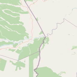
Interactive boundary visualization provides essential spatial context for the park's geographic layout. Companion geographic metrics detail the calculated total area, estimated perimeter, central coordinates, and spatial span.
- Boundary area
- 10,940.2 km²
- Boundary perimeter
- 891.7 km
- Northernmost point
- 12.6611° S
- Southernmost point
- 13.9443° S
- Easternmost point
- 68.7127° W
- Westernmost point
- 70.3396° W
- Geographic centre
- 13.3711° S, 69.4055° W
- North–south span
- 142 km
- East–west span
- 176.3 km
Elevation and terrain
Vertical range profile and recorded natural features
Bahuaja-Sonene National Park Elevation and Terrain Geography
Elevation summary records terrain variations spanning from 500 meters to 2450 meters across mixed relief zones. Linked natural feature cards detail specific river networks located within the protected area boundaries.
- Minimum elevation
- 500 m
- Maximum elevation
- 2,450 m
Selected named natural features
Rivers
Tambopata
Rivers
Río Heath
Environmental setting
Tropical forest habitats, mixed relief, and major water networks
Bahuaja-Sonene National Park Environmental Classifications
Stored classifications combine to outline the dominant tropical forest cover, mixed relief types, and major river systems shaping the physical setting of Bahuaja-Sonene National Park. Recorded categories link directly to corresponding atlas destinations for broader regional geography analysis.
- Relief
- Mixed relief
- Climate
- Tropical
- Water
- Major water bodies
- Forest cover
- Dense forest cover
Landscape features
Hills · Mountains · Valleys · Forest · Rivers
Habitat types
Tropical forest · Riverine habitat
Park atlas
Trace the mapped geography of Peru's vast Amazon frontier, exploring connected protected areas and their diverse landscapes.
Compare National Parks and Protected Areas Near Bahuaja-Sonene National Park and its Regional Landscapes
Explore other national parks and protected areas neighboring Bahuaja-Sonene National Park, tracing Peru's Amazon frontier and its critical transboundary conservation landscapes. Compare these diverse protected zones to understand their regional geographic context and their collective contribution to the Amazon's vast biodiversity and unique forest ecosystems.
National parkLa Paz Department
Park boundaries overlap#1 closest
East

Madidi National Park: National Park Protected Landscape and Geographic Atlas Entry
Explore mapped boundaries and regional context in La Paz Department.
Madidi National Park is a designated national park situated in Bolivia's La Paz Department. This detail entry offers a focused perspective on its protected landscape, its specific geographic setting, and its role within the larger atlas of natural areas. Understand the park's mapped boundaries and its contribution to the regional geography, providing a foundation for structured discovery of Bolivia's protected lands.
- Area
- 18,957.5 km²
- Established
- 1995
- IUCN
- II
- Relief
- Mixed relief
Wildlife reservePando Department
20 km away#2 closest
Northeast
Reserva nacional de vida silvestre amazónica Manuripi: Protected Amazonian Wilderness
Map and geographic context of Pando Department wildlife reserves
Spanning over 700,000 hectares, this wildlife reserve safeguards representative Amazonian ecosystems. Explore the hydrological network of the Madre de Dios and Manuripi river basins, ancient Brazil nut stands, and diverse wetland formations that define this significant regional protected area.
- Area
- 7,470 km²
- Established
- 1973
- Relief
- Lowland
- Climate
- Tropical
Wildlife reserveMadre de Dios Region
39 km away#3 closest
West

Amarakaeri Communal Reserve: Protected Geography and Amazonian Forest Mapping
Wildlife reserve in the Madre de Dios Region of Peru
Covering a large block of Amazonian forest, the Amarakaeri Communal Reserve marks the transition between flat lowland drainage basins and the rising slopes of the Peruvian Yungas. This protected area stands as a hallmark of indigenous-led conservation within the Madre de Dios Region, preserving natural terrain that ranges from dense riverine forests to Andean cloud forest vegetation. The reserve is also anchored by the Harakbut Face, a unique natural landmark formed by centuries of regional erosion.
- Relief
- Mixed relief
- Climate
- Tropical
- Access
- Access unknown
- Scope
- Terrestrial
National parkMadre de Dios Region
111 km away#4 closest
Northwest
Manu National Park: A National Park with Mapped Boundaries in Madre de Dios Region
Explore its protected landscape and regional geography.
Gain a detailed understanding of Manu National Park, a key protected area situated in Peru's Madre de Dios Region. This page offers in-depth information on its geographic context, allowing for focused exploration of its mapped terrain and its identity as a national park. Understand how this protected landscape contributes to the regional geography and provides a solid anchor for atlas-based research and discovery.
- Area
- 17,162.9 km²
- Established
- 1973
- IUCN
- II
- Relief
- Mixed relief
Protected areaBolivia
About 123 km away#5 closest
South
Área Natural de Manejo Integrado Apolobamba: Protected Landscape Geography and Andean Terrain
High-altitude glacial geography and Andean-Amazonian transition zones
Located in the department of La Paz, this protected area features a rugged landscape defined by tectonic uplift and Quaternary glaciation. It safeguards critical high-Andean habitats, including peatlands and Polylepis woodlands, while providing a essential refuge for vicuña populations within its steeply dissected mountain topography.
- Area
- 4,837.43 km²
- Established
- 1972
- Relief
- Mountain
- Climate
- Alpine
Protected areaBeni Department
About 176 km away#6 closest
Southeast
Área Protegida Municipal Rhukanrhuka: Mapping Amazonian Biodiversity and Riverine Terrain
A transitional protected landscape in the Beni Department of Bolivia
Spanning a vast transition from Andean slopes to the Llanos de Moxos floodplain, Área Protegida Municipal Rhukanrhuka protects a dynamic mosaic of white-water rivers, gallery forests, and tectonic lakes. This significant municipal reserve serves as a refuge for threatened species and sustains indigenous Maropa communities within its borders, anchoring an essential conservation corridor in the northern Amazon.
- Area
- 8,594.51 km²
- Established
- 2019
- Relief
- Lowland
- Climate
- Tropical
National parkPeru
189 km away#7 closest
Northwest
Alto Purús National Park: Peru's Protected National Park Landscape
Mapped boundaries and regional geographic context.
Investigate Alto Purús National Park, a designated national park within Peru. This detailed page provides essential context for understanding the park's geographic location, its protected status, and its role within the broader landscape of western South America. Explore the mapped features and regional setting that define this important conservation area.
- Area
- 25,106.9 km²
- Established
- 2004
- IUCN
- II
- Relief
- Mixed relief
Biosphere reserveBolivia
About 226 km away#8 closest
Southeast
Reserva de la Biosfera y Tierra Comunitaria de Origen Pilón Lajas Protected Landscape Atlas
Mapping the Andean Amazonian transition in northern Bolivia
Spanning from high mountain ridges to the river plains of the Beni, this protected area features a unique vertical gradient of ecosystems including cloud forests and terra firme. It represents a significant model for indigenous co governance and biodiversity protection within the broader Andean and Amazonian geographic context.
- Area
- 4,000 km²
- Established
- 1992
- Relief
- Mountain
- Climate
- Tropical
MoriAtlas Explorer
Continue Exploring Bahuaja-Sonene National Park's Protected Landscape Geography
Further your understanding of Bahuaja-Sonene National Park by exploring its specific mapped boundaries and the unique regional geography it occupies. This destination offers detailed insights into its role as a vital protected area within Peru and the broader Amazonian context. Investigate the natural terrain and landscape character that define this significant conservation landscape to enrich your geographic discovery.
Browse next
Global natural geography
Explore related park routes
Explore MoriAtlas Global ParksBrowse All MoriAtlas ParksGlobal Park Map DiscoveryMoriAtlas: Browse All CountriesBrowse All MoriAtlas ContinentsNational Park Environment AtlasGrand Canyon National Park AtlasYellowstone National Park AtlasYosemite National Park Atlas and GeographySerengeti National Park AtlasGalápagos National Park Protected LandscapeBanff National Park Geography and AtlasKruger National Park Atlas EntryUluṟu-Kata Tjuṯa National Park AtlasExplore Uluru-Kata Tjuta National Park GeographyPlitvice Lakes National Park AtlasFiordland National Park Protected LandscapeGreat Smoky Mountains National Park AtlasAfghanistan National Parks and Protected AreasAlbania National Parks and Protected AreasAlgeria National Parks and Protected AreasAmerican Samoa National Parks and Protected AreasAndorra National Parks and Protected AreasAngola National Parks and Protected AreasAntarctica National Parks and Protected AreasAntigua and Barbuda Park List