
Lakes
Park geography
A technical assessment of the 285.21 square kilometer protected landscape and its riverine ecosystem.
Barmah National Park Detailed Geographic Profile: Boundaries, Hydrology, and Terrain Analysis
This geographic overview examines the physical characteristics and environmental composition of Barmah National Park within the Hume region of Australia. The analysis covers the primary riverine landscapes, including the network of creeks and wetlands such as Compass Swamp and Harbours Lake, alongside the 285.21 square kilometer recorded area.
World's largest river red gum floodplain forest on the Murray River
Barmah National Park
Barmah National Park is a significant protected area in northern Victoria, Australia, located adjacent to the Murray River near the small town of Barmah approximately 225 kilometres north of Melbourne. The park encompasses 285 square kilometres of river red gum floodplain forest, representing the largest contiguous river red gum woodland on Earth. This landscape is interspersed with treeless freshwater marshes that form part of the internationally recognized Barmah Forest Ramsar site, a wetland of importance under the Ramsar Convention. The park was established as a national park in 2010, having previously operated as Barmah State Park since 1987, and is managed by Parks Victoria in collaboration with the traditional Yorta Yorta owners. The ecosystem supports extraordinary biodiversity, with numerous threatened flora and fauna species, and forms a critical component of the cross-border Murray Valley National Park that extends into New South Wales.
- Location
- Australia
- Park type
- National park
- Established
- 2010
- Area
- 285.2 km²
Location overview
Inland protected area within the Hume region of Australia
Geographic Location of Barmah National Park in Australia
Barmah National Park is located in the Hume region of Australia. The inland conservation area features a non-coastal, non-marine geography situated entirely within national borders.
- Countries
- Australia
- Regions
- Hume
- Primary location
- Australia
- Geographic setting
- Inland
Boundary and coordinates
Spatial limits and geographic dimensions across 285 square kilometers
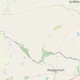
Barmah National Park Boundary Map and Geographic Limits
Interactive mapped geometry offers a clear overview of the spatial limits defining Barmah National Park. Accompanying data outlines the regional area, geographic center, and coordinate span to ground the protected landscape.
- Boundary area
- 285.1 km²
- Boundary perimeter
- 174.6 km
- Northernmost point
- 35.8204° S
- Southernmost point
- 35.9934° S
- Easternmost point
- 145.4572° E
- Westernmost point
- 144.9489° E
- Geographic centre
- 35.8883° S, 145.1057° E
- North–south span
- 19.2 km
- East–west span
- 45.9 km
Terrain and natural features
Explore recorded lowland terrain classifications and mapped internal water bodies
Barmah National Park Terrain and Named Natural Features
Barmah National Park encompasses a lowland terrain classification featuring multiple recorded rivers, lakes, and wetlands located within the protected boundary. Individual feature cards display specific names, types, and spatial relationships for each recorded natural element.
Selected named natural features
Wetlands
Black Swamp
Wetlands
Pig Hole
Rivers
Ulupna Creek
Beaches
Lagoon Beach
Rivers
Broken Creek
Environmental setting
Temperate lowland forest, wetland networks, and major riverine habitats
Barmah National Park Environmental Classifications and Physical Settings
Stored classifications combine lowland relief, temperate climates, and dominant forest cover to frame the physical setting. Recorded categories link directly to relevant atlas destinations for regional comparison.
- Relief
- Lowland
- Climate
- Temperate
- Water
- Major water bodies
- Forest cover
- Dense forest cover
Landscape features
Forest · Wetland · Rivers
Habitat types
Temperate broadleaf forest · Wetland · Riverine habitat
Park atlas
Browse the extensive network of protected areas across Victoria and the Murray River floodplain.
Discover Nearby National Parks and Protected Areas Beyond Barmah National Park
Continue your exploration from Barmah National Park to discover additional protected areas throughout the Murray River floodplain and surrounding Victorian landscapes. Map their distribution, compare distinct river red gum forests and wetlands, and trace the regional spread of conservation efforts in southeastern Australia.
National parkNew South Wales
0 km away#1 closest
North

Murray Valley National Park: Explore its Mapped Boundaries and Regional Geography in New South Wales
Protected landscape identity and geographic context.
Gain a structured understanding of Murray Valley National Park, a designated national park within New South Wales. This detail page provides essential geographic context, highlighting the park's mapped boundaries and its significance as a protected natural landscape. Utilize this entry point for comprehensive atlas-based exploration of its unique regional setting and terrain.
- Area
- 416.01 km²
- Established
- 2010
- IUCN
- II
- Relief
- Lowland
National parkAustralia
9.4 km away#2 closest
South
Lower Goulburn National Park: Australia's River Red Gum Woodland Protected Landscape
Explore mapped boundaries and riparian geography.
Lower Goulburn National Park in Victoria, Australia, safeguards a critical segment of the Goulburn River, celebrated for its magnificent river red gum woodlands. This protected area offers a linear exploration of a rare riparian ecosystem, providing essential habitat and scenic beauty. Understand its geographic layout, mapped extent, and the distinctive landscape formed by these iconic Australian trees, offering a vital natural contrast to the surrounding agricultural areas.
- Area
- 93.1 km²
- Established
- 2010
- IUCN
- II
- Relief
- Lowland
National parkAustralia
40 km away#3 closest
West
Gunbower National Park: A National Park Protecting River Red Gum Forests and Ramsar Wetlands
Explore its mapped riverine landscape and regional protected area context.
Gunbower National Park offers a unique glimpse into Victoria's vital floodplain ecosystems, prominently featuring extensive River Red Gum forests and Ramsar-designated wetlands. This protected national park, situated along the Murray River, serves as a crucial sanctuary for migratory bird species within the Murray-Darling Basin. Its landscape is defined by waterways like Gunbower Creek and a mosaic of aquatic habitats, representing an important conservation area for its ecological communities and geographic significance.
- Area
- 93.3 km²
- Established
- 2010
- IUCN
- II
- Relief
- Lowland
National parkAustralia
42 km away#4 closest
West
Terrick Terrick National Park: National Park Geography and Protected Land Exploration
Semi-arid woodland and grassland ecosystems in northern Victoria.
Terrick Terrick National Park represents a crucial protected area showcasing the characteristic Box-Ironbark forest and native grassland ecosystems of northern Victoria. This park is defined by its gently undulating terrain and semi-arid woodland character, offering a distinct natural landscape for geographic study and atlas exploration. Its mapped extent clearly delineates an environment vital for conservation, providing a valuable point of reference for understanding regional protected land distribution and ecological significance within Australia.
- Area
- 38.8 km²
- Established
- 1988
- IUCN
- II
- Relief
- Lowland
National parkAustralia
71 km away#5 closest
Southeast
Warby-Ovens National Park: Protected Landscape and Geographic Atlas Entry
Discover its Box-Ironbark forests and mapped regional terrain.
Warby-Ovens National Park is a protected national park situated in northeastern Victoria, Australia, covering 14,655 hectares of distinctive landscape. It is internationally recognized as an Important Bird Area, primarily for its significant Box-Ironbark forest ecosystem that supports numerous threatened woodland bird species. The park's geography features low granite hills and rolling terrain, with the Ovens River flowing through its northern section. This detail page provides structured information on its protected boundaries, natural landscape characteristics, and its place within regional geography.
- Area
- 146.55 km²
- Established
- 2010
- IUCN
- II
- Relief
- Upland
National parkAustralia
73 km away#6 closest
Southwest
Greater Bendigo National Park: Essential Protected Landscape and Regional Geography Details
Map exploration of its box-ironbark forest and woodland ecosystems.
Delve into Greater Bendigo National Park, a protected area in Victoria renowned for its extensive box-ironbark forests. This national park is crucial for maintaining the distinct woodland ecosystems that support rich bird populations and provide essential habitat for the endangered swift parrot. Users can explore its mapped geographic extent, understand its landscape character, and appreciate its significance within Australia's protected natural areas.
- Area
- 170 km²
- Established
- 2002
- IUCN
- II
- Relief
- Lowland
National parkAustralia
82 km away#7 closest
South
Heathcote-Graytown National Park: Protected Box-Ironbark Forests and Swift Parrot Habitat
Mapping the landscape and geography of this Australian National Park.
Heathcote-Graytown National Park is a significant protected area safeguarding one of Victoria's remaining box-ironbark forest ecosystems. Its landscape, nestled within the Great Dividing Range, provides essential habitat for migratory swift parrots and supports diverse woodland bird species recognized by BirdLife International. Explore the park's mapped terrain and understand its role within the Central Highlands' regional geography as a vital conservation landscape.
- Area
- 128.33 km²
- Established
- 2002
- IUCN
- II
- Relief
- Mountain
Nature reserveNew South Wales
About 90 km away#8 closest
Northeast
Lake Urana Nature Reserve: Geographic Atlas and Protected Area Mapping in Riverina
Inland salt-lake systems and dry box-pine woodland habitats
Lake Urana Nature Reserve functions as a representative protected zone within the Riverina region of New South Wales. The landscape transitions from the ephemeral salt-lake shoreline to native box-pine forests. This atlas entry details the protected boundaries and ecological characteristics of these arid-adapted inland plant communities and their role within the wider plains habitat network.
- Area
- 3.02 km²
- Established
- 1996
- IUCN
- Ia
- Relief
- Lowland
MoriAtlas Explorer
Continue Exploring Barmah National Park's Geographic and Protected Landscape Context
Delve deeper into the unique mapped terrain and regional geography of Barmah National Park, understanding its significance as a protected landscape and vital wetland. This exploration provides structured insights into the park's natural setting, its ecological importance within the Murray River system, and its place in the broader atlas of protected areas. Discover the distinct characteristics that define this exceptional natural environment.
Browse next
Global natural geography
Explore related park routes
Explore MoriAtlas Global ParksBrowse All MoriAtlas ParksGlobal Park Map DiscoveryMoriAtlas: Browse All CountriesBrowse All MoriAtlas ContinentsNational Park Environment AtlasGrand Canyon National Park AtlasYellowstone National Park AtlasYosemite National Park Atlas and GeographySerengeti National Park AtlasGalápagos National Park Protected LandscapeBanff National Park Geography and AtlasKruger National Park Atlas EntryUluṟu-Kata Tjuṯa National Park AtlasExplore Uluru-Kata Tjuta National Park GeographyPlitvice Lakes National Park AtlasFiordland National Park Protected LandscapeGreat Smoky Mountains National Park AtlasAfghanistan National Parks and Protected AreasAlbania National Parks and Protected AreasAlgeria National Parks and Protected AreasAmerican Samoa National Parks and Protected AreasAndorra National Parks and Protected AreasAngola National Parks and Protected AreasAntarctica National Parks and Protected AreasAntigua and Barbuda Park List