

Mori Atlas logo
Nature reserveBowra Sanctuary

Mapping the arid river plains, woodland corridors, and seasonal wetland geography

Bowra Sanctuary: A Protected Nature Reserve within the Mulga Lands of Southern Queensland

Bowra Sanctuary encompasses 140 square kilometres of protected terrain within the semi arid interior of southern Queensland. Positioned between the Warrego and Paroo River catchments, this reserve features a complex mosaic of mulga woodlands, alluvial plains, and gilgai wetlands. The landscape serves as a critical conservation area where diverse habitats support a vast array of native species adapted to the inland environment.

outbacknature reservearid zonebirdwatchingmulga woodlandwetlands

Bowra Sanctuary

Nature reserve

Park overview

Structured park overview, official facts, and landscape profile for Bowra Sanctuary

Bowra Sanctuary park facts, protected area profile, and essential visitor context

Review the core facts for Bowra Sanctuary, including designation, size, terrain, visitor scale, habitats, and operating context in one park-focused overview.

About Bowra Sanctuary

Bowra Sanctuary is a major private conservation property in the heart of the Queensland outback, bridging two of the most significant inland river systems of eastern Australia. Located on the Warrego River plains near Cunnamulla, it sits in the Mulga Lands bioregion, an ecologically distinctive zone characterised by mulga-dominated shrublands, open eucalypt woodlands, and seasonal flooding along slow-moving inland rivers. The reserve's position at the interface between the Warrego and Paroo catchments gives it exceptional habitat diversity for such a dry region.

The reserve has been protected and managed by the Australian Wildlife Conservancy since 2010, when it was acquired from the McLaren family, who had operated it as a cattle station for five generations. The purchase was supported by the Australian Government's National Reserve System and by Birds Australia, Bird Observation & Conservation Australia, Birds Queensland, and private donors. Since that time, Bowra has been managed primarily for biodiversity conservation rather than livestock production, and has become a flagship example of how former pastoral land can be transitioned into high-value habitat for native wildlife.

Bowra's landscape is defined by subtle contrasts in topography and soil. The northern part of the property rises into ridges and scarps clothed in mulga, mixed with poplar box and bloodwoods, while broad alluvial plains spread across the lower country, supporting open woodlands of gidgee and coolabah. The main watercourse, Gumholes Creek, is fringed by river red gums, and elsewhere wetlands such as swamps and gilgais introduce patches of distinctive microhabitat into the otherwise semi-arid terrain. The variety of woodland, riparian, and seasonal wetland environments is the foundation for the reserve's biological richness, and underpins its national reputation for birdwatching and arid-zone conservation.

Quick facts and research context for Bowra Sanctuary

Bowra Sanctuary covers roughly 140 square kilometres of former pastoral country in South West Queensland, near Cunnamulla. It sits within the Mulga Lands bioregion on the Warrego River plains, between the catchments of the Warrego and Paroo Rivers. The reserve is owned and operated by the Australian Wildlife Conservancy as a private conservation property, and is classified as an IUCN Category VI protected area with sustainable use of natural resources.

The landscape mixes mulga-dominated ridges and scarps in the north with extensive alluvial plains of gidgee and coolabah woodlands. River red gums line Gumholes Creek, the reserve's main watercourse, and additional wetlands include swamps and gilgais. Over 200 bird species have been recorded, alongside a diverse assemblage of small mammals, reptiles, and frogs adapted to semi-arid conditions.

Protection and recognition

Review verified terrestrial boundaries, management parameters, and international recognition records.

Bowra Sanctuary Protection Status and Documented Conservation Scope

Bowra Sanctuary operates under a defined terrestrial protection framework with documented conservation boundaries and management parameters. Structured records outline available designation details, administrative scope, and official recognition metrics for the reserve.

Protection details

Protection scope
Terrestrial
Transboundary protection
No
Park context

Deeper park guide and search-rich context for Bowra Sanctuary

Bowra Sanctuary history, landscape, wildlife, and travel context

Explore Bowra Sanctuary through its history, landscape character, ecosystems, wildlife, conservation priorities, cultural context, and seasonal travel timing in a structured park guide built for atlas discovery and search intent.

Why Bowra Sanctuary stands out

Bowra Sanctuary is especially known for its remarkable concentration of birdlife in the otherwise dry, sparsely wooded outback of southern Queensland. Its mix of mulga ridges, gidgee and coolabah plains, and creekline eucalypts creates habitat for more than 200 bird species, including 14 parrot species, 18 diurnal raptors, and a long list of sought-after woodland specialists. Several rare and range-restricted birds are closely associated with the property, including Hall's babbler, chestnut-breasted quail-thrush, Bourke's parrot, and Major Mitchell's cockatoo. Bowra is also notable as a breeding site for the grey falcon and as a recording location for the elusive Australian painted snipe. This combination of arid-zone habitats and rich bird diversity has made Bowra one of the recognised birdwatching destinations of inland Australia.
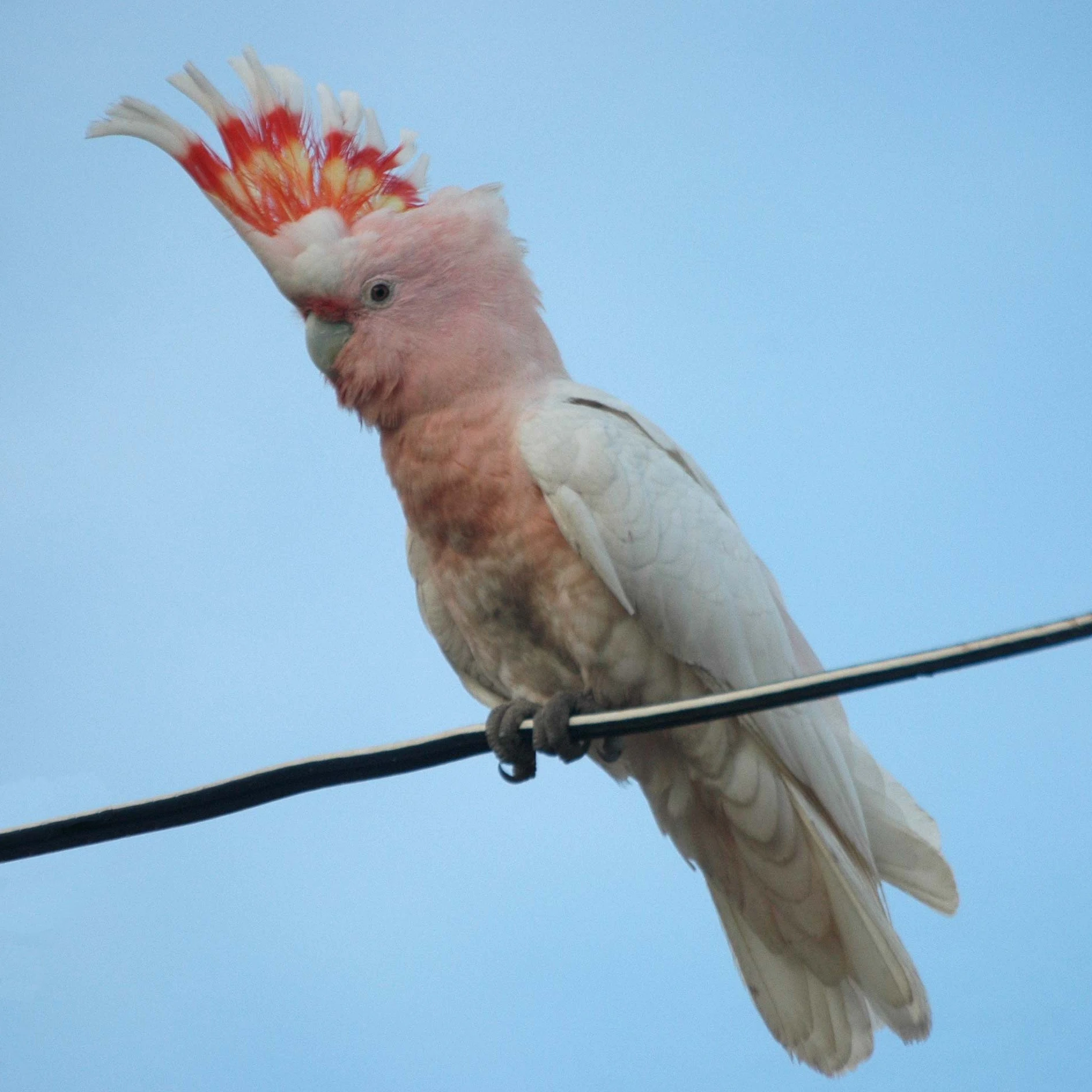
A pale pink and white cockatoo with a striking red and yellow crest stands on a black wire against a clear blue sky.
A Major Mitchell's cockatoo perched on a wire at Bowra Sanctuary.

Bowra Sanctuary history and protected-area timeline

Bowra was held for five generations by the McLaren family as a working cattle station in the pastoral country of South West Queensland. As the property's ecological value became increasingly recognised, particularly for its birdlife, conservation groups began efforts to secure it for long-term protection.

In 2010, the Australian Wildlife Conservancy purchased Bowra with financial and institutional support from a coalition of partners. The Australian Government's National Reserve System contributed to the acquisition, alongside Birds Australia, Bird Observation & Conservation Australia, Birds Queensland, and a number of private donors. The transition from a cattle station to a conservation reserve marked a significant shift in land use for what had previously been managed primarily for livestock production.

Since its acquisition, Bowra has been managed by the AWC as a dedicated wildlife sanctuary. Its establishment is part of a broader pattern of private conservation acquisitions across the Australian outback, in which large former pastoral holdings are being protected for their habitat values and reconnected with broader landscape-scale conservation goals.

Bowra Sanctuary landscape and geographic character

The terrain of Bowra Sanctuary is shaped by the gently undulating Warrego River plains in the semi-arid interior of southern Queensland. The northern part of the reserve rises into low scarps and ridges that support denser woodland vegetation, while flatter alluvial country dominates the south and east. Streams and floodplains associated with Gumholes Creek, part of the Warrego catchment, dissect the property and introduce localised greener corridors of vegetation into the broader dryland mosaic.

At a finer scale, the reserve's landforms include gilgais, which are shallow, natural depressions and mounds formed by the swelling and shrinking of clay soils under variable moisture conditions. These small-scale features create micro-relief that holds water for longer after rainfall and supports distinctive wetland vegetation. Swamps associated with these depressions add to the landscape's hydrological diversity.

The result is a varied setting in which ridges, plains, creeklines, and small wetlands interact across relatively short distances. Although flat by world standards, this terrain is ecologically significant precisely because of these contrasts, which allow different plant and animal communities to coexist within a single property.

Bowra Sanctuary ecosystems, habitats, and plant life

Bowra's ecosystems reflect a transitional position between drier mulga shrublands and the open eucalypt woodlands of the inland floodplains. The northern scarps and ridges carry communities of mulga, interspersed with poplar box and bloodwoods, giving way on the lower country to broad expanses of gidgee and coolabah open woodland. Along Gumholes Creek, river red gums form a distinctive riparian corridor that contrasts sharply with the surrounding dryland vegetation.

Gilgais and swamps add a third layer to the reserve's habitat structure. These seasonal wetlands fill after rains and contract during dry periods, supporting different suites of plants and invertebrates and providing important resources for waterbirds and other wildlife. The combination of mulga ridges, alluvial plains, riparian woodland, and seasonal wetlands produces the habitat complexity needed to support a wide variety of bird species, particularly those that depend on multiple vegetation types within a single landscape.

Bowra Sanctuary wildlife and species highlights

Bowra Sanctuary is most celebrated for its birds, with more than 200 species recorded across the reserve. The property is a recognised destination for birdwatchers interested in Australia's arid interior, supporting 14 species of parrots, including Bourke's parrot and Major Mitchell's cockatoo, and 18 diurnal raptors, among them the grey falcon, which breeds on the reserve. Iconic woodland species such as Hall's babbler, chestnut-breasted quail-thrush, crested bellbird, and diamond firetail are also present. Among roughly 50 species of waterbirds, the rare Australian painted snipe has been recorded, underlining the importance of the reserve's seasonal wetlands for species that depend on variable inland water conditions. Other threatened or declining species documented at Bowra include the painted honeyeater and the squatter pigeon.

Beyond birds, the reserve supports a diverse range of mammals, reptiles, and frogs. Small marsupials include the fat-tailed dunnart and stripe-faced dunnart, while the rare kultarr has also been recorded. Reptiles are an important component of the fauna as well. The threatened yakka skink is present on the property, which also provides habitat suitable for the woma python, a large snake associated with intact inland woodland and sandridge environments. The combination of small mammals, ground-dwelling reptiles, and seasonal amphibians reflects the broader role of the reserve in supporting a wide cross-section of arid-zone wildlife.

Bowra Sanctuary conservation status and protection priorities

Bowra Sanctuary is significant from a conservation perspective because it protects a large, ecologically rich block of habitat within the Mulga Lands bioregion, an area that has been extensively modified by grazing and other land uses. By removing cattle and managing the property explicitly for native wildlife, the Australian Wildlife Conservancy has created conditions under which woodland and wetland habitats can recover, and threatened species can find refuge.

The reserve contributes to the conservation of several species of national concern, including Major Mitchell's cockatoo, painted honeyeater, squatter pigeon, crested bellbird, diamond firetail, yakka skink, and kultarr, as well as water-dependent species such as the Australian painted snipe. Its mix of mulga, open eucalypt woodland, riparian forest along Gumholes Creek, and seasonal wetlands provides habitat for a high diversity of woodland and waterbirds at a landscape scale that is increasingly rare in the Australian outback.

Its acquisition under the National Reserve System, with support from avian conservation organisations and private donors, also reflects the broader role of collaborative, non-government conservation in safeguarding large properties in sparsely populated regions. Bowra stands as both a refuge for arid-zone wildlife and a working example of private conservation management in Australia.

Bowra Sanctuary cultural meaning and human context

The cultural context of Bowra Sanctuary is tied closely to the long pastoral history of the Queensland outback. For five generations the property was operated by the McLaren family as a cattle station, a form of land use that shaped much of the surrounding region and remains central to the identity of South West Queensland. The transition of Bowra from a working cattle property to a dedicated wildlife sanctuary therefore represents a significant shift in land-use philosophy, in which a long-established pastoral landscape is being recast as a conservation landscape.

The reserve also has an important place in the birdwatching culture of Australia. As a recognised site for species such as Hall's babbler, Major Mitchell's cockatoo, and the grey falcon, Bowra draws birders from across the country and contributes to a community of interest around arid-zone birds.

Top sights and standout views in Bowra Sanctuary

Bowra Sanctuary's most distinctive highlights are its exceptional bird diversity within an arid-zone setting, the quality of its woodland and wetland habitats, and its role as a large, actively managed private conservation property. The combination of mulga ridges, gidgee and coolabah plains, river red gum creeklines, and seasonal gilgai wetlands produces the habitat variety needed to support more than 200 bird species and a rich suite of other native animals. The sanctuary's protection under the Australian Wildlife Conservancy places it among the more important privately managed reserves in the Australian outback.

Best time to visit Bowra Sanctuary

Like much of the Australian outback, Bowra Sanctuary experiences strongly seasonal conditions that shape both the landscape and the wildlife experience. Periods following rainfall tend to fill the reserve's swamps and gilgais, attract waterbirds, and increase activity among wildlife more broadly. The cooler months of the southern autumn, winter, and early spring are generally associated with milder temperatures and more comfortable outback conditions, and are widely favoured for birdwatching visits. Drier, hotter periods can be more demanding for visitors and may limit the visibility of some wildlife around the wetlands.
Monthly climate preview

Long-term representative point measurements tracking annual temperature and precipitation rhythm

Bowra Sanctuary Climate Normals and Measured Monthly Temperature Ranges

Bowra Sanctuary records documented baseline temperature and precipitation normals derived from long-term NASA coordinate sampling across the terrain. Reviewing the complete monthly profile provides detailed historical context on annual thermal variations and precipitation patterns.
Annual mean22 °C
12 °C30 °C
Jan30°
Feb29°
Mar26°
Apr22°
May16°
Jun13°
Jul12°
Aug14°
Sep19°
Oct23°
Nov26°
Dec29°
Warmest month
January

30.5 °C

Coolest month
July

11.9 °C

Wettest month
January

1.9 mm/day

Driest month
August

0.5 mm/day

Park location guide

Geography guide, regional context, and park location map for Bowra Sanctuary

Bowra Sanctuary park geography, regions, and map view in Australia

Understand where Bowra Sanctuary sits in Australia through a broader geographic reading of the surrounding landscape, nearby location context, and its mapped position within the national park landscape.

How Bowra Sanctuary fits into Australia

Australia is a constitutional monarchy and federal parliamentary democracy comprising six states and ten territories. With a population of nearly 28 million, it is one of the world's most urbanised countries, with most people concentrated on the eastern seaboard. The country has a high Human Development Index and is known for its cultural diversity, ancient Aboriginal heritage, and unique wildlife.

Wider geography shaping Bowra Sanctuary in Australia

Australia occupies the entire Australian continent, the island of Tasmania, and numerous smaller islands. It is the world's flattest and driest inhabited continent, featuring vast deserts in the interior (the Outback), tropical rainforests along the eastern coast, and a coastline bordering the Indian and Pacific Oceans.

Map view of Bowra Sanctuary

Use this park location map to pinpoint Bowra Sanctuary in Australia, understand its exact geographic position, and read its mapped placement within the surrounding landscape more clearly.

Pigeon | © OpenStreetMap contributors

Location context for Bowra Sanctuary

Queensland

Visualizing arid woodlands, river floodplains, and protected habitats across the outback reserve

Bowra Sanctuary Photos and Landscape Scenery Exploration

Visual records reveal the diverse terrain of Bowra Sanctuary, ranging from mulga ridges to seasonal wetland depressions across the Warrego River plains. Examining these habitat photographs helps researchers understand the complex ecological character and arid zone adaptations of the reserve.

A pale pink and white cockatoo with a striking red and yellow crest stands on a black wire against a clear blue sky.

Park atlas

Compare surrounding arid reserves and inland conservation areas in southern Queensland

Other Parks Near Bowra Sanctuary and Protected Landscapes Across the Outback

Browse nearby national parks and protected areas sharing the distinctive arid terrain, mulga woodlands, and riverine habitats of Bowra Sanctuary. Expanding the search across the surrounding region reveals how different conservation reserves protect the fragile ecosystems of the Australian interior.
National parkQueensland
About 136 km away#1 closest

Southwest

Currawinya National Park: Queensland's Ramsar Wetland and Mulga Lands National Park

Discover its arid landscape and protected area identity.

Currawinya National Park is a major protected area in Queensland, Australia, recognized for its significant Ramsar-listed wetland system, including Lakes Numalla and Wyara. These ephemeral lakes are vital drought refuges for waterbirds across inland Australia and represent a unique ecological feature within the park's expansive mulga lands landscape. The park also champions conservation initiatives, notably a large predator-exclusion enclosure for the greater bilby, showcasing its commitment to arid-zone biodiversity and landscape preservation.

Area
1,513 km²
Established
1991
IUCN
II
Relief
Lowland
National parkAustralia
About 137 km away#2 closest

East

Narkoola National Park: Understanding Its Protected Landscape and Australian Geography

Discover mapped boundaries and natural terrain context.

Narkoola National Park stands as a key protected area within Australia, providing valuable insights into its specific geography and natural landscape characteristics. This detailed view focuses on understanding the park's mapped boundaries, its terrain, and its role within the larger Australian geographic atlas. Explore the protected land's context and uncover its distinct landscape features for a deeper geographic appreciation.

Area
117.99 km²
Established
2010
IUCN
II
Climate
Arid
National parkQueensland
About 137 km away#3 closest

West

Lake Bindegolly National Park: A Mapped Protected Wetland Sanctuary in Queensland

Discover its rare flora and vital bird habitat in the Mulga Lands.

Lake Bindegolly National Park is a significant protected natural area situated in the Mulga Lands of Queensland, Australia. This national park preserves a unique three-lake system, essential for rare plant conservation and recognized internationally as an Important Bird Area. The transient wetlands within the park attract a remarkable diversity of bird species, especially waterfowl, making it a key destination for understanding inland Australian geography and the importance of protected landscapes.

Area
140 km²
Established
1991
IUCN
II
Relief
Lowland
National parkQueensland
About 151 km away#4 closest

Southeast

Culgoa Floodplain National Park: Queensland National Park and Protected Landscape Identity

Explore mapped boundaries and regional geographic context.

Culgoa Floodplain National Park is a designated national park located in Queensland, Australia. This page details its identity as a protected landscape, emphasizing its geographical placement within the northeastern Australian region. Users can discover the park's mapped boundaries, understand its role within Queensland's geography, and engage with atlas-style exploration tools focused on conservation lands and natural terrain.

Area
428.59 km²
Established
1994
IUCN
II
Relief
Lowland
National parkAustralia
About 162 km away#5 closest

Southeast

Culgoa National Park: Iconic Coolabah Woodlands and River Floodplain Landscapes of Australia

Explore mapped boundaries and regional geography in this New South Wales protected area.

Culgoa National Park is a premier example of a preserved semi-arid outback landscape in Australia, celebrated for its extensive and intact coolabah woodlands. This national park protects vital river floodplains and a chain of permanent waterholes along the Culgoa River, contributing significantly to the biodiversity of the Darling River catchment. Understanding its geographic setting and the mapped distribution of its unique vegetation communities offers deep insight into Australia's natural heritage.

Area
352.39 km²
Established
1996
IUCN
II
Relief
Lowland
National parkQueensland
About 194 km away#6 closest

East

Thrushton National Park: Queensland's Mulga Lands National Park and Protected Landscape

Explore the semi-arid terrain and mapped conservation boundaries.

Thrushton National Park represents a crucial protected landscape within Queensland's Mulga Lands, preserving vast expanses of dense mulga scrub, spinifex sandplains, and dry woodlands. As a National Park, it offers a unique window into the semi-arid ecology of inland Australia, characterized by its subtly undulating terrain and sandy soils. This atlas-focused exploration highlights the park's distinctive vegetation communities and its regional geographic significance, providing a factual base for understanding this vital conservation area.

Area
256.52 km²
Established
1990
IUCN
II
Scope
Terrestrial
National parkQueensland
About 214 km away#7 closest

North

Mariala National Park: Queensland's Premier Mulga Lands Protected Landscape

Explore mapped terrain and regional geography.

Mariala National Park stands as a landmark designation, preserving the extensive mulga woodlands and semi-arid plains characteristic of Queensland's Mulga Lands bioregion. As the first protected area of its kind, it offers a profound insight into the ecological distinctiveness of inland Australia. This park provides a unique opportunity to explore a largely unmodified landscape, understand its role in conserving rare bird habitats, and appreciate its geographic significance within the broader Queensland atlas.

Area
269.2 km²
Established
1992
IUCN
II
Relief
Lowland
Watercolor illustration showing rolling hills, scattered trees, and distant mountains in a natural landscape.
National parkQueensland
About 219 km away#8 closest

Northeast

Tregole National Park: Queensland National Park with Significant Ooline Woodlands

Explore unique semi-arid protected landscape and Ooline tree stands.

Tregole National Park in Queensland, Australia, is a protected natural area celebrated for its remarkable Ooline tree concentrations. This park offers a rare look at pure Ooline stands within a hot, dry inland climate, showcasing a significant example of semi-arid ecosystems. Its landscape represents the meeting point of brigalow and mulga biospheres, providing valuable context for understanding Australia's diverse protected areas and geographic regions within the MoriAtlas framework.

Area
75.79 km²
Established
1995
IUCN
II
Relief
Lowland

Common questions about visiting, size, designation, and location context for Bowra Sanctuary

Bowra Sanctuary FAQs for park facts, access, geography, and protected area context

Find quick answers about Bowra Sanctuary, including protected-area facts, park geography, trail and visitor context, and how the park fits into its surrounding country and regional landscape.
MoriAtlas Explorer

Continue Your Protected Areas Search Across the Global Atlas

Deepen your exploration by continuing the structured search for national parks and protected areas worldwide. Utilize the comprehensive filtering capabilities to compare different conservation landscapes and refine your understanding of global park geography. Discover more about the distribution and characteristics of protected natural areas.

Global natural geography