
Rivers
Park geography
Structured data on regional spread, mountain terrain, and forest landscape features
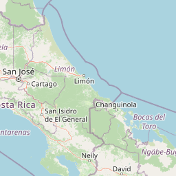
Geographic Profile and Mapped Boundaries of Braulio Carrillo National Park, Costa Rica
This geographic profile details the physical scope and environmental characteristics of Braulio Carrillo National Park, which extends across four regions in Costa Rica. The site provides structured data on its 475.8 square kilometer area, mountain-dominated terrain, and major natural features including Volcán Barva and multiple forested peaks.
Related tags
Cloud ForestVolcanic LandscapeBiodiversity hotspotPrimary ForestMountain Parks
Costa Rica's accessible wilderness between the Central Valley and Caribbean coast
Braulio Carrillo National Park
Braulio Carrillo National Park is a vast protected area in central Costa Rica spanning four provinces: Heredia, Cartago, Limón, and San José. Established in 1978, the park was created following environmental advocacy that successfully limited development along the newly constructed Limon Highway, which now bisects the park connecting the capital San José to the Caribbean port of Puerto Limón. The park is named after Braulio Carrillo, a 19th-century Costa Rican president whose administration built the first road linking the capital to the Caribbean coast. Covering approximately 476 square kilometers, the park protects a remarkable range of ecosystems from high-altitude cloud forests down to tropical lowland rainforests, representing some of the highest biodiversity in Costa Rica. Unlike the more visited tourist destinations in Costa Rica, Braulio Carrillo remains relatively wild and untraveled, offering visitors a more remote and immersive natural experience.
- Location
- Costa Rica
- Park type
- National park
- Established
- 1978
- Area
- 475.8 km²
Location overview
Provincial distribution across multiple regions of Costa Rica
Geographic Setting of Braulio Carrillo National Park in Costa Rica
Braulio Carrillo National Park spans the Costa Rican provinces of Heredia, Cartago, San José, and Limón. Classified as an inland, non-transboundary protected area, the reserve lies entirely within Costa Rican borders.
- Countries
- Costa Rica
- Regions
- Cartago Province, Heredia Province, Limón Province, San José Province
- Primary location
- Heredia Province
- Geographic setting
- Inland
Boundary and coordinates
Analyzing the 475.8 square kilometer spatial footprint and coordinate span
Braulio Carrillo National Park Boundary Map and Spatial Geography
Cartographic outlines define the shape and geographic placement of the protected landscape. Structured spatial data profiles the 475.8 square kilometer area alongside regional coordinates, spans, and centroid data.
- Boundary area
- 499.3 km²
- Boundary perimeter
- 152.5 km
- Northernmost point
- 10.4294° N
- Southernmost point
- 10.0507° N
- Easternmost point
- 83.8753° W
- Westernmost point
- 84.1285° W
- Geographic centre
- 10.1762° N, 84.0199° W
- North–south span
- 41.9 km
- East–west span
- 27.7 km
Terrain and natural features
Mapped mountain terrain classifications and recorded hydrologic features
Braulio Carrillo National Park Terrain and Natural Features
Mountain terrain classifications shape the regional scope across interior protected landscapes and river basins. Stored feature cards document recorded peaks, rivers, and waterfalls located within the conservation area.
Selected named natural features
Peaks
Cerro Delicias
2,290 m
Ponds
Laguna Copey
2,650 m
Rivers
Quebrada Sanguijuela
Lakes
Río Hondura
Rivers
Río Blanco
Environmental setting
Interpreting dominant forest cover, mountainous relief, and aquatic networks
Braulio Carrillo National Park Environmental Classifications and Physical Settings
Recorded habitat types and landscape features serve as complementary metrics for reading the physical setting of Braulio Carrillo National Park. Stored environmental categories link directly to associated protected areas across the broader geographic atlas.
- Relief
- Mountain
- Water
- Major water bodies
- Forest cover
- Dense forest cover
- Seasonality
- Year-round
Landscape features
Mountains · Forest · Lakes · Rivers
Habitat types
Montane forest · Temperate broadleaf forest · Tropical forest · Riverine habitat · Lacustrine habitat
Park atlas
Browse the connected protected landscapes and regional park geography near Braulio Carrillo National Park.
Discover Other National Parks and Protected Areas Near Braulio Carrillo National Park
Explore additional national parks and protected areas in Costa Rica that share geographic proximity, ecological features, or volcanic landscapes with Braulio Carrillo National Park. Comparing these conservation landscapes provides a deeper understanding of regional biodiversity, the extent of cloud forests, and the broader protected area network.
National parkCartago Province
7 km away#1 closest
Southeast

Irazú Volcano National Park: National Park Protected Area Atlas
Mapped Boundaries and Volcanic Terrain
Irazú Volcano National Park stands as a distinct protected area within the landscape of Cartago Province, Costa Rica. This page provides an atlas-centric view, detailing the park's mapped boundaries and its identity as a national park. Explore the volcanic geography and regional context, understanding its contribution to the protected lands of Central America.
- Area
- 20 km²
- Established
- 1955
- IUCN
- II
- Relief
- Mountain
National parkAlajuela Province
7.2 km away#2 closest
West
Poás Volcano National Park: National Park Protected Landscape in Alajuela Province
Mapped park boundaries and regional terrain context.
Poás Volcano National Park represents a vital protected landscape within Costa Rica's Alajuela Province. This detail page offers an atlas-centric view, emphasizing the park's geographic identity, its specific mapped boundaries, and its significance as a national park. Explore the natural terrain and understand the regional context of this protected area, ideal for geographic discovery and landscape exploration.
- Area
- 65 km²
- Established
- 1971
- IUCN
- II
- Relief
- Mountain
National parkCosta Rica
11 km away#3 closest
Southeast
Turrialba Volcano National Park: Mapped Geography and Protected Landscape Context in Costa Rica
Explore the protected area's natural terrain and regional atlas placement
Turrialba Volcano National Park is a key protected landscape in Costa Rica, offering distinct geographic features and environmental context for atlas exploration. This page details the park's mapped boundaries and its significance as a national park, providing a foundation for understanding its place within the country's diverse natural terrain. Discover the unique geographic identity of this protected area and its role in the regional landscape.
- Area
- 16 km²
- Established
- 1955
- IUCN
- II
- Relief
- Mountain
National parkAlajuela Province
17 km away#4 closest
West
Juan Castro Blanco National Park: National Park Boundaries and Alajuela Province Geography
Explore the protected landscape within north-central Costa Rica.
Juan Castro Blanco National Park offers a distinct protected landscape for geographic study within Alajuela Province. This national park serves as a key entity for exploring mapped boundaries, understanding local terrain, and situating its protected area within the broader atlas of Costa Rica. Delve into the specific geographic context and natural landscape features that define this important park.
- Area
- 145 km²
- Established
- 1992
- IUCN
- II
- Relief
- Mountain
National parkCosta Rica
33 km away#5 closest
Southeast
Tapantí National Park: Costa Rica National Park Atlas and Mapped Landscape Exploration
Explore protected boundaries and natural terrain within its geographic setting.
Tapantí National Park is a designated national park in Costa Rica, offering specific insights into the country's protected natural landscapes. This page provides an atlas-style view of its geographic placement, the extent of its protected area, and the character of its natural terrain. Users can investigate the park's mapped context and understand its significance within the broader geography of Costa Rica, facilitating focused exploration of protected lands and regional landscape features.
- Area
- 583.2 km²
- Established
- 1982
- IUCN
- II
- Relief
- Mountain
Nature reserveNicaragua
36 km away#6 closest
North

Indio Maíz Biological Reserve: Protected Landscape and Geographic Identity
Lowland rainforest and riverine systems of southeastern Nicaragua
Indio Maíz Biological Reserve stands as one of Central America's largest protected blocks of tropical forest. Characterized by dense, humid lowlands and extensive river systems like the San Juan, this reserve serves as a critical biodiversity stronghold and a significant example of indigenous-led land stewardship in the region.
- Area
- 2,639 km²
- Established
- 1990
- Relief
- Lowland
- Climate
- Tropical
National parkLimón Province
44 km away#7 closest
Northeast
Tortuguero National Park: Protected Landscape and Regional Geographic Context
National Park mapped in Limón Province, Costa Rica.
Delve into Tortuguero National Park, a significant national park situated in Limón Province, Costa Rica. This entry offers detailed insights into its protected area status, mapped geographic extent, and its role within the regional natural landscape context. Ideal for users seeking a structured atlas view of protected lands and their geographical distribution, providing foundational data for understanding this specific conservation landscape.
- Area
- 312 km²
- Established
- 1975
- IUCN
- II
- Visitors
- 10K annual
National parkCosta Rica
46 km away#8 closest
South
Los Quetzales National Park: Costa Rica National Park Landscape and Mapped Geography
Explore protected area boundaries and regional terrain context.
Los Quetzales National Park, a designated national park within Costa Rica, offers a focused entry point for exploring protected landscapes. This page provides detailed insight into the park's geographic setting, emphasizing its mapped boundaries and its role within the national atlas. Users can discover the specific landscape characteristics and regional terrain that define Los Quetzales National Park, enriching their understanding of Costa Rican protected areas.
- Area
- 50 km²
- Established
- 2006
- IUCN
- II
- Relief
- Mountain
MoriAtlas Explorer
Continue exploring Braulio Carrillo National Park's mapped landscape and regional geography
Deepen your understanding of Braulio Carrillo National Park by delving into its specific geographic features and protected landscape context. This detailed view helps map its position within Heredia Province and contributes to a comprehensive atlas of protected areas, revealing its unique terrain and ecological significance. Continue your discovery of this important national park's mapped identity.
Browse next
Global natural geography
Explore related park routes
Explore MoriAtlas Global ParksBrowse All MoriAtlas ParksGlobal Park Map DiscoveryMoriAtlas: Browse All CountriesBrowse All MoriAtlas ContinentsNational Park Environment AtlasGrand Canyon National Park AtlasYellowstone National Park AtlasYosemite National Park Atlas and GeographySerengeti National Park AtlasGalápagos National Park Protected LandscapeBanff National Park Geography and AtlasKruger National Park Atlas EntryUluṟu-Kata Tjuṯa National Park AtlasExplore Uluru-Kata Tjuta National Park GeographyPlitvice Lakes National Park AtlasFiordland National Park Protected LandscapeGreat Smoky Mountains National Park AtlasAfghanistan National Parks and Protected AreasAlbania National Parks and Protected AreasAlgeria National Parks and Protected AreasAmerican Samoa National Parks and Protected AreasAndorra National Parks and Protected AreasAngola National Parks and Protected AreasAntarctica National Parks and Protected AreasAntigua and Barbuda Park List