Mori Atlas logo
Protected areaCascada de Texolo

A detailed geographic look at the ravine terrain, stream systems, and Ramsar-recognized woodlands.

Cascada de Texolo Protected Area: Mapping the Forested Waterfalls of the Veracruz Highlands

(Cascadas de Texolo y su entorno)

Cascada de Texolo forms a vital protected forest and stream ecosystem within the Veracruz highlands of eastern Mexico. This landscape is defined by a narrow, moss-rich gorge where the primary waterfall drops into a shadowed ravine, flanked by dense cloud forest vegetation. Beyond the main cascade, the area encompasses a wider network of stream corridors and smaller falls that provide a complex, tiered terrain for geographic study and mapped observation.

WaterfallCloud forestMontane forestRamsar WetlandVeracruz highlandsGorge and ravine

Cascada de Texolo

Protected area

Park overview

Structured park overview, official facts, and landscape profile for Cascada de Texolo

Cascada de Texolo park facts, protected area profile, and essential visitor context

Review the core facts for Cascada de Texolo, including designation, size, terrain, visitor scale, habitats, and operating context in one park-focused overview.

About Cascada de Texolo

Cascada de Texolo is a wooded waterfall site in the state of Veracruz, in eastern Mexico. It sits within the central highland region, just south of the town of Xico and within relatively easy reach of the state capital, Xalapa. The setting is one of the most visually striking natural landmarks in the area, defined by a tall cascade plunging into a narrow, densely vegetated gorge.

The principal waterfall is roughly eighteen to twenty-four metres high, falling into a rocky basin framed by trees, lianas, and other cloud forest vegetation characteristic of the region's montane environment. A bridge spans the gorge near the main falls, connecting both sides of the forest and providing a vantage point over the drop. From trails on the far side of the bridge, visitors can see two additional smaller cascades set further along the ravine, creating a layered landscape of waterfalls and forest corridors.

The site is officially recognized as a Ramsar Wetland, designated in 2006 under the formal name "Cascadas de Texolo y su entorno." This designation reflects the broader environmental context of Texolo, which extends beyond the waterfall itself to include the surrounding streams, forest cover, and ecological processes tied to the watershed. The recognition underscores the value of the humid montane forest and the waterfall ecosystem as a habitat complex rather than a single geological feature.

Beyond its natural and ecological character, Cascada de Texolo has a notable cultural footprint. The waterfall and gorge appeared in major international films, most famously in the adventure movie Romancing the Stone, where a fictional cave scene was staged at the falls. The site also appeared in Clear and Present Danger. These appearances have helped anchor Texolo in popular imagination as one of Mexico's most photogenic natural settings.

Quick facts and research context for Cascada de Texolo

Cascada de Texolo is a waterfall in central Veracruz, Mexico, located a few kilometres south of the town of Xico and roughly nineteen kilometres from the state capital, Xalapa. The principal cascade drops roughly eighteen to twenty-four metres into a forested gorge crossed by a suspension-style bridge.

The site was designated as a Ramsar Wetland of international importance on 2 February 2006 under the official name "Cascadas de Texolo y su entorno," reflecting the protected status of the surrounding woodlands and stream ecosystem. The area is also notable for its appearance in feature films, including Romancing the Stone and Clear and Present Danger.

Protection and recognition

Documented terrestrial protection scope, 2006 designation history, and Ramsar records.

Cascada de Texolo Protection Status and Official International Recognition Data

Terrestrial protection status for Cascada de Texolo is detailed alongside official designation history from 2006. Documented international recognition data covers the Cascadas de Texolo y su entorno Ramsar site context.

International recognition

Protection details

Protection scope
Terrestrial
Designated year
2006
Transboundary protection
No
Park context

Deeper park guide and search-rich context for Cascada de Texolo

Cascada de Texolo history, landscape, wildlife, and travel context

Explore Cascada de Texolo through its history, landscape character, ecosystems, wildlife, conservation priorities, cultural context, and seasonal travel timing in a structured park guide built for atlas discovery and search intent.

Why Cascada de Texolo stands out

Cascada de Texolo is best known for its dramatic forested waterfall setting within the Veracruz highlands. The main cascade drops into a narrow, vegetation-lined gorge, while a pedestrian bridge spans the ravine and additional smaller falls are reachable via local footpaths. The combination of dense tropical woodland, a setting near the town of Xico, and conservation recognition under the Ramsar Convention gives the site a distinctive ecological and cultural profile. Another defining association is its role as a filming location. The falls stood in for a fictional South American setting in the adventure film Romancing the Stone, where the plot's hidden cave and jewel scene was filmed at Texolo. This cinematic visibility, alongside the park's natural appeal, has made Texolo a recognizable point of interest far beyond the Xalapa region.
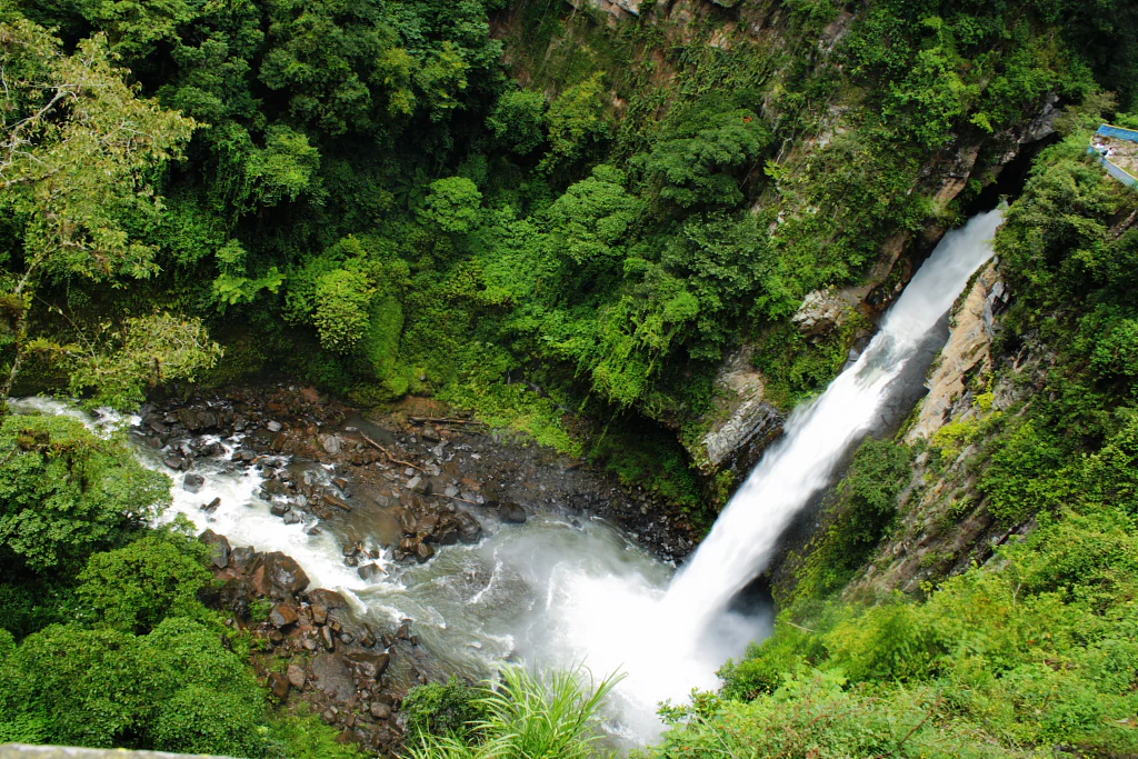
An elevated view of a tall waterfall plunging into a river canyon surrounded by dense green forest.
The Cascada de Texolo waterfall situated within the dense woodland of Veracruz.

Cascada de Texolo history and protected-area timeline

The natural waterfall at Texolo has long been part of the landscape surrounding the town of Xico and the broader Xalapa region, forming a focal point for local footpaths and recreation. Its broader environmental and cultural profile, however, became formalized in the early twenty-first century when the site received international recognition.

On 2 February 2006, the area encompassing the main waterfall and its surrounding terrain was inscribed as a Ramsar Wetland of international importance under the name "Cascadas de Texolo y su entorno." The Ramsar designation highlighted the ecological value of the humid forest and waterfall system, bringing the site into a global framework of wetland conservation.

In parallel, the visual identity of Texolo expanded through cinema. The waterfall and gorge were used as filming locations for Hollywood productions, including Romancing the Stone, in which Texolo stood in for a South American jungle setting in a pivotal cave-and-jewel scene. The site also appeared in Clear and Present Danger. Together, the formal conservation designation and the international film appearances have shaped Texolo's modern identity as both a protected natural area and a recognized cultural landmark.

No detailed timeline of tourist infrastructure or formal protected-area management is documented in the available sources, and the site's history is here summarized only where directly supported.

Cascada de Texolo landscape and geographic character

The landscape at Cascada de Texolo is shaped by a narrow, vegetation-filled gorge cut into the central Veracruz highlands. The principal waterfall drops roughly eighteen to twenty-four metres from a forested ledge into the ravine below, with the falling water framed by dense trees, mossy rocks, and lush understory typical of humid montane forest.

A bridge spans the gorge near the main cascade, linking the two wooded slopes and offering a direct view over the drop. Beyond the bridge, the trail network extends deeper into the ravine, where visitors can glimpse two additional smaller cascades further along the stream system. Together, the main falls, the secondary cascades, and the connecting footpaths create a tiered landscape of falling water and forest corridors.

The surrounding terrain reflects the broader character of the Xico and Xalapa region, with steep wooded slopes, persistent humidity in the forest canopy, and a stream system that feeds directly into the waterfall. The visual drama of the falls comes as much from this tight integration of rock, water, and dense vegetation as from the height of the main drop itself.
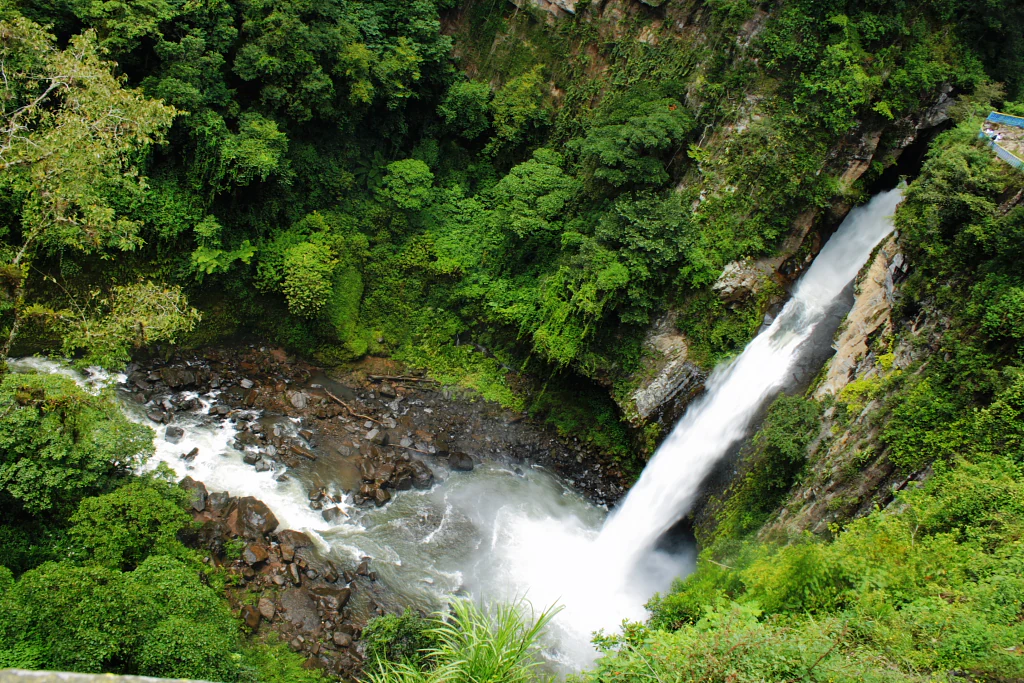
A high-angle view of a large waterfall plunging into a pool within a dense, green forest canyon.
The Cascada de Texolo waterfall cascading into a lush, forested gorge in Veracruz, Mexico.

Cascada de Texolo ecosystems, habitats, and plant life

The ecological character of Texolo is tied to its humid montane forest setting, where the waterfall is the central feature of a broader stream and forest ecosystem. The dense vegetation surrounding the cascade supports a moist, shaded environment typical of the Veracruz highlands, with the gorge and adjacent slopes acting as corridors for humidity-loving plant species.

The waterfall's continuous spray and the shaded conditions of the ravine sustain mosses, ferns, and humidity-dependent understory plants along the rock faces and forest floor. The surrounding woodlands form the wider habitat context of the site, connecting the waterfall area with the regional forest landscape that extends into the Xalapa area.

The "Cascadas de Texolo y su entorno" Ramsar designation specifically acknowledges this integrated wetland system. Rather than focusing solely on the cascade, the designation recognizes the streams, forest cover, and microhabitats tied to the waterfall as a coherent ecological unit of conservation interest.
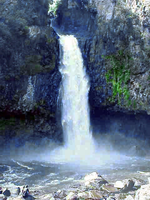
A vertical waterfall cascading down a dark, rocky cliff face into a misty pool, surrounded by dense green vegetation.
The Cascada de Texolo waterfall flowing into the basin in Veracruz, Mexico.

Cascada de Texolo wildlife and species highlights

The available sources do not provide a detailed inventory of specific species at Cascada de Texolo. The site's dense montane forest setting, combined with its recognized status as a Ramsar Wetland, suggests habitat conditions favorable to a typical range of cloud forest and stream-associated fauna of the Veracruz highlands.

The waterfall and gorge environment, with its persistent humidity, mossy rock faces, and closed canopy, provides shelter and humidity for amphibians, insects, and a range of forest-dwelling birds typical of the region. Streams feeding the cascade may also support aquatic life associated with clear, oxygenated upland water.

A general wildlife characterization of Texolo would be consistent with the broader ecology of protected humid forest sites in central Veracruz, but specific species-level detail is not available in the provided sources.
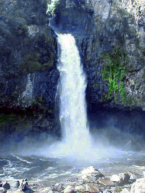
A tall waterfall cascading down a steep, rocky cliff face into a pool at the bottom, surrounded by lush vegetation.
The Cascada de Texolo waterfall near Xico, Veracruz, in its forested gorge setting.

Cascada de Texolo conservation status and protection priorities

The defining conservation marker for Cascada de Texolo is its inscription as a Ramsar Wetland of international importance. The designation, dated 2 February 2006 under the name "Cascadas de Texolo y su entorno," placed the site within the framework of the Ramsar Convention on Wetlands, which recognizes wetlands of significant ecological, scientific, or cultural value.

The wording of the official name, which explicitly includes "y su entorno" (and its surroundings), reflects the conservation logic that the protection value of Texolo lies not only in the waterfall itself but in the surrounding forest, streams, and ravine systems. This holistic framing underscores the site's role as a habitat complex shaped by water, vegetation, and topographic relief.

For visitors, the Ramsar designation signals that the area has been formally evaluated at the international level for its ecological importance, and that the surrounding forest supporting the waterfall is recognized as a resource worth preserving alongside the cascade itself.

Cascada de Texolo cultural meaning and human context

The waterfall sits in close proximity to the town of Xico, a settlement with deep regional roots in the Veracruz highlands. The proximity of Texolo to Xico and to the state capital, Xalapa, ties the natural site into the everyday geography of the region, where forested ravines, streams, and waterfalls are part of the local landscape and recreational life.

Texolo also has an unusual layer of international cultural visibility through cinema. The site served as a filming location for major Hollywood productions, most notably Romancing the Stone, where the waterfall's lush appearance was used to evoke a fictional South American jungle environment. The same area appeared in Clear and Present Danger. These film appearances connect a relatively localized natural landmark to international popular culture in a way that few comparable Mexican waterfalls share.

Within Mexico, Texolo is recognized as a regional natural attraction and an accessible escape from Xalapa, reflecting the broader cultural pattern of highland Veracruzian communities being closely tied to nearby forested landscapes for recreation and local identity.

Top sights and standout views in Cascada de Texolo

The standout feature of Cascada de Texolo is the combination of a tall, narrow waterfall and the dense, moss-rich forest that surrounds it. The main cascade drops roughly eighteen to twenty-four metres into a shadowed gorge, with a bridge offering a direct view across the ravine and footpaths leading onward to two smaller cascades.

Equally distinctive is the site's recognition under the Ramsar Convention as "Cascadas de Texolo y su entorno," a designation that frames Texolo not as an isolated waterfall but as a protected forest-and-stream ecosystem. Its international profile is further amplified by its appearance in feature films, including Romancing the Stone, where Texolo stood in for an iconic jungle setting.

Best time to visit Cascada de Texolo

The available sources do not provide detailed seasonal visitation guidance for Cascada de Texolo. As a humid montane forest waterfall in central Veracruz, the site's character is shaped by regional rainfall patterns, with the wetter months typically bringing fuller flow to the cascade and richer green conditions in the surrounding forest, and drier months offering clearer trails and more open views of the rock faces around the falls.

Seasonal experience at Texolo is therefore best understood in terms of trade-offs between waterfall flow, trail conditions, and forest atmosphere, rather than as a fixed calendar of visit windows. Visitors seeking the most dramatic cascade volume will find the wetter season of the Veracruz highlands most expressive, while those prioritizing clear footpaths and easier access along the ravine will generally find drier conditions more comfortable.
Monthly climate preview

Long-term representative monthly averages for temperature and precipitation rhythms

Cascada de Texolo Climate Normals and Annual Temperature Patterns

Representative coordinate records show measured monthly temperature variations alongside shifting daily precipitation averages across the protected site. Analyzing the complete twelve-month climatology profile reveals distinct long-term weather patterns across the landscape.
Annual mean19 °C
15 °C23 °C
Jan15°
Feb17°
Mar19°
Apr22°
May23°
Jun22°
Jul21°
Aug21°
Sep20°
Oct19°
Nov17°
Dec15°
Warmest month
May

22.9 °C

Coolest month
January

15 °C

Wettest month
September

9 mm/day

Driest month
February

1.1 mm/day

Park location guide

Geography guide, regional context, and park location map for Cascada de Texolo

Cascada de Texolo park geography, regions, and map view in Mexico

Understand where Cascada de Texolo sits in Mexico through a broader geographic reading of the surrounding landscape, nearby location context, and its mapped position within the national park landscape.

How Cascada de Texolo fits into Mexico

Mexico, officially the United Mexican States, is a country in North America spanning the Sierra Madre mountain ranges, coastal plains, and tropical regions. It borders the United States to the north, Guatemala and Belize to the southeast, and has coastlines along the Pacific Ocean, Gulf of Mexico, and Caribbean Sea. With a population exceeding 130 million, Mexico is home to one of the world's most significant concentrations of Indigenous languages alongside Spanish.

Wider geography shaping Cascada de Texolo in Mexico

Mexico occupies a land area of 1,972,550 km2, making it the thirteenth-largest country in the world. The terrain is highly diverse, featuring the Sierra Madre Occidental and Sierra Madre Oriental mountain ranges, the Mexican Plateau, coastal lowlands along the Pacific and Gulf/Caribbean margins, and the Yucatan Peninsula. The country spans multiple climate zones from desert in the north to tropical rainforest in the south.

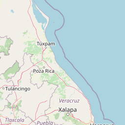
Map view of Cascada de Texolo

Use this park location map to pinpoint Cascada de Texolo in Mexico, understand its exact geographic position, and read its mapped placement within the surrounding landscape more clearly.

Pigeon | © OpenStreetMap contributors

Location context for Cascada de Texolo

Veracruz

Visual exploration of protected forest gorges, waterfalls, and montane habitats.

Cascada de Texolo Photos and Landscape Scenery in the Veracruz Highlands

Protected area imagery captures the dramatic vertical drop and humid cloud forest canopy of Cascada de Texolo in eastern Mexico. Visual documentation of the gorge, ravines, and stream corridors reveals the distinctive montane environment and ecological character of the regional landscape.

An elevated view of a tall waterfall plunging into a river canyon surrounded by dense green forest.

A large waterfall flows down a rocky cliff into a river running through a steep, lush, forested gorge.

A high-angle view of a large waterfall plunging into a pool within a dense, green forest canyon.

A vertical waterfall cascading down a dark, rocky cliff face into a misty pool, surrounded by dense green vegetation.

A tall waterfall cascading down a steep, rocky cliff face into a pool at the bottom, surrounded by lush vegetation.

Park atlas

Compare regional forested gorges and surrounding highland reserves

Explore Protected Areas and Parks Near Cascada de Texolo

Browse protected natural areas and related parks near Cascada de Texolo to examine similar montane forest ecosystems across the region. Regional comparison provides deeper geographic context for understanding the humid woodlands and river corridors of Veracruz.
National parkMexico
About 19 km away#1 closest

Northwest

Cofre de Perote National Park: A National Park within Mexico's Geographic Atlas

Explore its protected landscape and regional map context.

Cofre de Perote National Park is a vital protected area within Mexico, offering a unique national park designation. This entry focuses on its geographic significance, mapping its boundaries and situating it within the country's broader protected lands. Users can explore the park's landscape identity and its atlas-relevant features, providing a factual basis for understanding its role in Mexico's natural heritage.

Established
1937
IUCN
II
Relief
Mountain
Climate
Alpine
National parkMexico
About 50 km away#2 closest

Southwest

Pico de Orizaba National Park: Mexico's Key National Park for Atlas Exploration

Discover mapped boundaries and regional geographic context.

Access detailed atlas information for Pico de Orizaba National Park, a protected natural area in Mexico. This entry focuses on its geographic scope, mapped landscape features, and its significance as a national park within the region. Explore the park's protected boundaries and understand its place in the broader geographical context of Mexico.

IUCN
II
National parkVeracruz
About 67 km away#3 closest

South

Cañón del Río Blanco National Park: Explore Its Mapped Protected Area and Regional Geography

Discover the geographic context and protected landscape of this national park.

Cañón del Río Blanco National Park offers a distinct protected-area identity within the geography of Veracruz. This canonical page focuses on the park's mapped boundaries and its significance as a national park. Use this resource for structured exploration of its protected landscape and regional setting, enhancing your understanding of Mexican protected areas.

Area
488 km²
Established
1938
IUCN
II
Relief
Mountain
National parkTlaxcala
About 112 km away#4 closest

West

La Malinche National Park: Protected Landscape and Regional Geography in Tlaxcala

Explore mapped boundaries and natural terrain.

La Malinche National Park is a vital protected landscape offering rich insights into regional geography and natural terrain. This canonical entry provides focused details on the park's protected area identity, its mapped geographic scope within Tlaxcala, and its place in the broader atlas of Mexican conservation lands. Understand the specific landscape characteristics and geographic context that define this significant national park.

Established
1938
IUCN
II
Relief
Mountain
Access
Moderate access
National parkMexico
About 129 km away#5 closest

East

Sistema Arrecifal Veracruzano National Marine Park: Mexico's Coastal National Park

Explore mapped boundaries and regional protected landscape.

Delve into the protected landscape of Sistema Arrecifal Veracruzano National Marine Park, a vital national park situated off the coast of Mexico. This page provides detailed insights into its mapped boundaries and geographic context, crucial for understanding the distribution of protected marine areas within the region. It serves as a gateway to appreciating the park's specific contribution to Mexico's conservation efforts and its place in broader geographic atlases.

IUCN
VI
Scope
Marine
Water
Water-dominated
Protected areaPuebla
About 138 km away#6 closest

Northwest

Zona Protectora Forestal Vedada Cuenca Hidrográfica del Río Necaxa: Mountain Watershed Atlas

Protected Sierra Madre Oriental mountain landscapes and reservoirs

This protected area safeguards the complex upper watershed of the Necaxa River, where dense cloud forests meet engineered reservoirs. Spanning the mountainous border region, the area serves as a key case study in forest conservation, river basin management, and wetland habitat protection within the broader geographic framework of the Sierra Madre Oriental.

Area
421.29 km²
Established
1938
IUCN
VI
Relief
Mountain
A watercolor painting showing a soft green wetland with calm water, grassy shorelines, and distant rolling hills in pale pink and green hues.
Protected areaVeracruz
About 146 km away#7 closest

Southeast

Alvarado Lagoon System: Mapping the Protected Coastal Wetlands of Veracruz, Mexico

An essential reference for Gulf Coastal Plain wetland geography

The Alvarado Lagoon System acts as a major estuarine node within the southern Gulf Coastal Plain. This protected area connects the Papaloapan River watershed to the Gulf of Mexico through an intricate network of lagoons, mangrove forests, and coastal dunes, providing a vital window into the regional landscape of Veracruz.

Area
2,670.1 km²
Established
2004
Relief
Lowland
Climate
Tropical
National parkMexico
About 176 km away#8 closest

West

Iztaccíhuatl, Popocatépetl National Park: Mexico's National Park Protected Area

Mapped boundaries and regional geographic context.

Iztaccíhuatl, Popocatépetl National Park is a protected natural landscape offering insight into Mexico's geography. This atlas entry focuses on the park's defined boundaries and its role within the national protected areas framework. Explore the unique geographic character and mapped extent of this significant park, understanding its position within the country's natural landscape atlas.

Area
398.19 km²
Established
1935
IUCN
II
Relief
Mountain

Common questions about visiting, size, designation, and location context for Cascada de Texolo

Cascada de Texolo FAQs for park facts, access, geography, and protected area context

Find quick answers about Cascada de Texolo, including protected-area facts, park geography, trail and visitor context, and how the park fits into its surrounding country and regional landscape.
MoriAtlas Explorer

Continue Your Protected Areas Search Across the Global Atlas

Deepen your exploration by continuing the structured search for national parks and protected areas worldwide. Utilize the comprehensive filtering capabilities to compare different conservation landscapes and refine your understanding of global park geography. Discover more about the distribution and characteristics of protected natural areas.

Global natural geography