Peaks
Кучето
1,676 m

A comprehensive analysis of terrain, regional administrative coverage, and natural physical features.
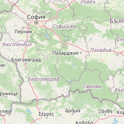
Examine the structured geographic data for Central Balkan National Park, a vast protected region spanning 716.69 square kilometers across five Bulgarian provinces. This profile details the park topography, including elevations ranging from 550 to 2376 meters, and catalogs major peaks such as Botev, Malak Kupen, and Tetevenksa Baba within the recorded mountain landscape.
Bulgaria's mountain heartland of ancient beech forests and dramatic alpine landscapes
Central Balkan National Park is one of Bulgaria's three national parks, situated in the heart of the Balkan Mountains (Stara Planina) in central Bulgaria. Established in 1991, the park spans approximately 717 square kilometers, making it the third-largest protected area in Bulgaria. The park encompasses the central and higher portions of the Balkan Range, with elevations ranging from about 550 meters near the town of Karlovo to 2,376 meters at Botev Peak, the highest summit in the entire mountain range. The park is distinguished by its exceptional biodiversity and preserved natural ecosystems. It lies within the Rodope montane mixed forests ecoregion of the Palearctic realm and contains nine nature reserves that cover nearly 28% of its total territory. The ancient beech forests within these reserves have been recognized as part of the Primeval Beech Forests of the Carpathians and Other Regions of Europe World Heritage Site since 2017. The park's forests cover about 56% of its area, with 97% being of natural origin. The landscape features dramatic alpine meadows, vertical rock faces, deep canyons, and numerous waterfalls, creating a distinctive mountain environment that supports remarkable biological diversity. Central Balkan National Park holds significant international conservation status. It is categorized as IUCN Category II (National Park) and has been designated as a UN Representative Protected Area. Several of its nature reserves are included in the UNESCO World Network of Biosphere Reserves, reflecting its importance as a model of sustainable nature conservation in Europe.
Regional distribution across five provinces in the heart of Bulgaria
Exploring spatial dimensions and the 716.69 square kilometer total area
Mountain relief metrics and recorded natural features
Peaks
1,676 m
Peaks
1,976.8 m
Peaks
1,215 m
Peaks
1,794.1 m
Peaks
2,100.5 m
Waterfalls
35 m high
Temperate climate zones, mountain relief, and broadleaf forest coverage profiles
Mountains · Valleys · Cliffs · Forest · Grassland
Temperate broadleaf forest · Alpine meadow · Grassland
Trace contiguous protected landscapes and compare adjacent park geography within the Balkan Mountains region and Lovech Province.
Southwest

Explore mapped boundaries and protected landscape features.
Rila National Park, situated in Bulgaria's Rila mountain range, stands as the country's largest national park and a vital protected landscape. Its territory is characterized by dramatic glacial topography, including the iconic Seven Rila Lakes, and ascends to Musala Peak, the highest summit in the Balkan Peninsula. This atlas entry details the park's extensive mapped boundaries and unique ecosystems, emphasizing its importance for understanding regional geography and protected area networks.
Southwest
Explore Pirin National Park's mapped boundaries and landscape.
Pirin National Park serves as a vital national park entity within the atlas of Blagoevgrad Province, Bulgaria. This page details its protected landscape, offering a structured view of its geographic setting and mapped terrain. Users can investigate the park's specific identity and its relation to the surrounding regional geography, providing essential context for understanding protected areas and natural landscapes within a comprehensive map-driven framework.
South

Mapped boundaries, old-growth ecosystems, and Balkan geography.
Rodopi Mountain Range National Park is a critical protected forest area in Greece, safeguarding one of Europe's last primeval forests, the Frakto Virgin Forest. As the nation's largest woodland conservation site, it showcases remarkable biodiversity and complex mountain terrain, from low-lying forests to subalpine meadows. This page provides detailed mapping context and geographic specifics for understanding this unique protected landscape and its ecological significance within the Rhodope Mountains.
West

Mapped protected landscape and regional geography discovery
Stara Planina National Park is a newly established national park in eastern Serbia, notable for its extensive mountain terrain and designation within the Balkan Mountains. This protected area features the distinctive Kopren plateau, Tupavica waterfall, and rugged landmarks, all contributing to its unique geographic identity. MoriAtlas provides a structured atlas view of Stara Planina National Park, detailing its protected boundaries and landscape context for comprehensive discovery.
West
Discover its mountain lake ecosystem and mapped natural landscape.
Vlasina Ramsar Wetland is a critical protected area in Serbia, notable for its high-altitude mountain lake and river ecosystem within the Rhodopian Mountains. This page details its mapped geographic boundaries, unique terrain, and protected landscape identity, offering users a focused atlas exploration of a significant natural site. Delve into the specific geography and conservation context that define this internationally recognized wetland.
Northeast

Giurgiu County, Romania: Mapped protected area context.
Navigate the geographic features and protected landscape boundaries of Comana Natural Park, situated within Giurgiu County. This dedicated atlas entry provides a clear view of the park's mapped territory and its significance as a protected area, offering essential context for understanding its regional setting and natural terrain within Romania.
West
Mapping the unique limestone cliffs and river valley terrain.
Delve into the atlas details of Sićevo Gorge, a protected landscape in Serbia defined by its spectacular limestone cliffs and the Nišava River canyon. This page provides a structured overview of its dramatic topography, intricate karst formations, and the regional geographic context. Understand the mapped boundaries and the unique geological character that makes this gorge a standout feature in Serbia's natural landscape.
South
Coastal lagoons and river delta protected landscapes
Gain insight into the ecological and geographic structure of Parc national de Macédoine-Orientale-et-Thrace. This protected area encompasses a complex mosaic of river deltas, shifting saline lagoons, and remnant riparian forests that anchor the natural landscape of Eastern Macedonia and Thrace.
Delve deeper into the geographic context of Central Balkan National Park, understanding its role as a protected landscape within Bulgaria's mountainous terrain. Use MoriAtlas to trace its mapped boundaries, discover its diverse natural features, and appreciate its significance as a major protected area. Continuing your exploration here offers a structured view into one of Europe's most ecologically valuable mountain environments.