
Streams
Park geography
Mapped boundaries, environmental features, and regional terrain context.
Structured Geographic Profile of Corner Inlet Marine National Park in Australia
Examine the technical geography and physical boundaries of Corner Inlet Marine National Park, a marine protected area situated in Australia. This data profile presents the 15.5 square kilometer extent, coastal and wetland environments, and localized natural features including bays, beaches, and island landforms within the Bass Strait.
Related tags
marine national parkRamsar sitecoastal wetlandseagrass habitatVictoria protected area
Ramsar-listed marine protected area in South Gippsland, Victoria
Corner Inlet Marine National Park
Corner Inlet Marine National Park is a marine protected area located in the South Gippsland region of Victoria, Australia. The park encompasses approximately 1,550 hectares of marine and coastal environments centered around Corner Inlet, a significant coastal inlet system situated roughly 200 kilometres southeast of Melbourne. As a marine national park under IUCN category II, it forms part of a broader network of protected areas along Victoria's coastline and is integrally linked to the adjacent Corner Inlet Marine and Coastal Park. The park protects a diverse range of marine and wetland habitats that support ecological communities typical of temperate southern Australian waters.
- Location
- Australia
- Park type
- Marine protected area
- Established
- 2002
- Area
- 15.5 km²
Location overview
National coastal and marine conservation territory of Australia
Geographic Profile of Corner Inlet Marine National Park in Australia
Corner Inlet Marine National Park is situated within the sovereign coastal waters of Australia. Designated as a strictly marine and coastal reserve, the protected area operates under Australian national jurisdiction.
- Countries
- Australia
- Primary location
- Australia
- Geographic setting
- Coastal · Marine
Boundary and coordinates
Map the protected waters covering 15.5 square kilometers of marine area.
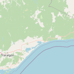
Geographic Boundary and Spatial Extent of Corner Inlet Marine National Park
The mapped spatial boundary reveals how Corner Inlet Marine National Park sits within the coastal landscape. Companion geographic data outlines the estimated area, center coordinates, and latitudinal span of the protected zone.
- Boundary area
- 14.1 km²
- Boundary perimeter
- 30.1 km
- Northernmost point
- 38.7841° S
- Southernmost point
- 38.8605° S
- Easternmost point
- 146.4382° E
- Westernmost point
- 146.3692° E
- Geographic centre
- 38.8203° S, 146.4014° E
- North–south span
- 8.5 km
- East–west span
- 6 km
Terrain and natural features
Explore lowland terrain classifications and mapped natural features within the park
Corner Inlet Marine National Park Terrain and Named Natural Features
Corner Inlet Marine National Park features recorded lowland terrain classifications alongside specific streams, bays, islands, wetlands, beaches, and straits. Linked feature cards supply names, types, measurements, and spatial relationships for each recorded entity.
Selected named natural features
Bays
Shallow Bight
Islands
Bennison Island
Wetlands
Chinaman Swamp
Bays
Freshwater Cove
Beaches
Chinaman Long Beach
Environmental setting
Temperate climate zones, marine waters, and lowland coastal wetlands
Corner Inlet Marine National Park Environmental and Habitat Classifications
Recorded habitat types and landscape features serve as complementary lenses for reading the physical setting of Corner Inlet Marine National Park. Stored environmental categories connect directly to related protected area destinations across the regional atlas.
- Relief
- Lowland
- Climate
- Temperate
- Water
- Major water bodies
Landscape features
Coast · Wetland
Habitat types
Wetland · Coastal habitat · Marine habitat
Park atlas
Browse marine and coastal protected areas, tracing regional park geography across Victoria, Australia.
Explore Nearby National Parks and Protected Areas Surrounding Corner Inlet Marine National Park
Continue exploration from Corner Inlet Marine National Park by browsing nearby national parks, marine protected areas, and coastal wetlands within Victoria's South Gippsland region. Explore this geographic compilation to compare adjacent conservation landscapes and understand their interconnected role within Australia's broader protected area network.
National parkAustralia
Park boundaries overlap#1 closest
South

Wilsons Promontory National Park: Southernmost Australian National Park with Granite Landscapes and Rainforests
Mapped geography of a dramatic coastal and wilderness park.
Wilsons Promontory National Park, situated at Australia's southern mainland extremity, represents a significant protected landscape. The park's geography is defined by ancient granite formations, creating dramatic peaks and headlands that meet the Bass Strait. Within its boundaries, diverse ecosystems flourish, including rare temperate rainforests and heathy woodlands. This page provides detailed geographic context and atlas-style discovery for this iconic protected area.
- Area
- 505 km²
- Established
- 1898
- IUCN
- II
- Relief
- Mixed relief
Marine protected areaAustralia
21 km away#2 closest
South
Wilsons Promontory Marine National Park: Australia's Southern Marine Protected Landscape
Explore mapped boundaries and island ecosystems at the edge of Bass Strait.
Wilsons Promontory Marine National Park, a 15,500-hectare marine protected area in Victoria, Australia, offers unique atlas exploration of its coastal and island geography. The park's waters surround the Glennie and Anser island groups, showcasing a complex marine terrain where Bass Strait transitions into the Southern Ocean. It complements the adjacent terrestrial national park, creating a comprehensive protected landscape vital for marine biodiversity and regional geographic context. Discover its mapped marine environment and ecologically significant island habitats.
- Area
- 155 km²
- Established
- 2003
- IUCN
- II
- Scope
- Marine
Marine protected areaVictoria
29 km away#3 closest
Southeast
Beagle Commonwealth Marine Reserve: Mapping Bass Strait and Victorian Marine Protected Areas
Submerged continental shelf and Bassian Plain geography
The Beagle Commonwealth Marine Reserve protects nearly 3,000 square kilometres of the Bass Strait seabed. This site offers deep insight into the region's submerged landscape history, featuring geological remnants of the ancient Bassian Plain and a series of rugged island archipelagos that frame this temperate marine environment.
- Area
- 2,928 km²
- Established
- 2007
- IUCN
- VI
- Relief
- Lowland
National parkAustralia
37 km away#4 closest
Northeast
Tarra-Bulga National Park: Ancient Mountain Ash Forest Protected Landscape in Victoria
Explore mapped fern gullies and temperate rainforest ecosystems.
Tarra-Bulga National Park is a protected national park in Victoria, Australia, renowned for its spectacular old-growth mountain ash forests and lush fern gullies. This significant fragment of temperate rainforest offers a unique window into the region's natural heritage and geographic past. Discover the mapped landscape character, including towering trees and vibrant undergrowth, making it a key destination for protected-area exploration.
- Area
- 15.22 km²
- Established
- 1986
- IUCN
- II
- Visitors
- 80K annual
National parkAustralia
45 km away#5 closest
North
Morwell National Park: Protected Landscape Diversity in Victoria's Strzelecki Ranges
Explore the mapped terrain and unique forest ecosystems.
Morwell National Park, an Australian national park in the Strzelecki Ranges, is celebrated for its extraordinary plant and animal diversity within a concentrated area. The park preserves critical wet sclerophyll forests and delicate temperate rainforest pockets within deep gullies, offering a distinct landscape character. Its establishment reflects a significant community-driven conservation effort, making it a valuable site for understanding regional protected-area geography and landscape richness.
- Area
- 5.65 km²
- Established
- 1966
- IUCN
- III
- Relief
- Highland
National parkAustralia
61 km away#6 closest
West
Bunurong Marine National Park: Protected Marine Area with Diverse Reefs and Coastal Landscapes
Explore unique rock formations and rich marine biodiversity off Victoria's coast.
Bunurong Marine National Park in Victoria, Australia, is a designated national park safeguarding remarkable marine ecosystems. Its protected geography features striking coastal features like Eagles Nest and a wealth of subtidal and intertidal rocky reefs teeming with life. This area is renowned for its high marine invertebrate diversity, significant fossil sites such as the Cape Paterson Claw discovery, and provides exceptional opportunities for mapped landscape exploration of its underwater terrains.
- Area
- 21 km²
- Established
- 2002
- IUCN
- II
- Visitors
- 250K annual
Marine protected areaAustralia
74 km away#7 closest
Northeast
Ninety Mile Beach Marine National Park: Victoria's Coastal Marine Protected Area
Mapped boundaries and temperate marine landscape context.
Ninety Mile Beach Marine National Park represents a significant commitment to marine conservation along the eastern Victorian coast. This protected area safeguards the underwater ecosystems adjacent to the celebrated Ninety Mile Beach, a nearly 100-kilometer stretch of continuous sandy shoreline. Its establishment in 2002 preserves the marine biodiversity and coastal landscape character of this region, forming an integral part of Victoria's network of protected coastal environments and offering a distinct view of Australia's marine geography.
- Area
- 27.5 km²
- Established
- 2002
- IUCN
- II
- Scope
- Marine
National parkAustralia
90 km away#8 closest
Northwest
French Island National Park: Protected Island National Park with Coastal Wetland Habitats
Explore mapped boundaries and diverse terrain of this unique park.
French Island National Park preserves a vital island ecosystem in Victoria, Australia, featuring extensive mangrove forests, salt marshes, and open woodland. As one of Australia's most accessible island national parks, it offers a distinctive wilderness experience primarily reached by boat, showcasing coastal conservation and unique wetland habitats. The park's geography is defined by its low-lying terrain and tidal influences, creating a rich environment for mapped landscape exploration.
- Area
- 111 km²
- Established
- 1998
- IUCN
- II
- Relief
- Lowland
MoriAtlas Explorer
Continue Exploring Corner Inlet Marine National Park's Protected Landscape and Geography
Delve deeper into the mapped protected area of Corner Inlet Marine National Park to understand its unique coastal wetland geography and ecological role. This exploration provides essential context for appreciating the park's place within Australia's network of marine protected areas and natural landscapes. Understand the mapped boundaries and tidal dynamics that define this significant Ramsar site and its contribution to regional conservation.
Browse next
Global natural geography
Explore related park routes
Explore MoriAtlas Global ParksBrowse All MoriAtlas ParksGlobal Park Map DiscoveryMoriAtlas: Browse All CountriesBrowse All MoriAtlas ContinentsNational Park Environment AtlasGrand Canyon National Park AtlasYellowstone National Park AtlasYosemite National Park Atlas and GeographySerengeti National Park AtlasGalápagos National Park Protected LandscapeBanff National Park Geography and AtlasKruger National Park Atlas EntryUluṟu-Kata Tjuṯa National Park AtlasExplore Uluru-Kata Tjuta National Park GeographyPlitvice Lakes National Park AtlasFiordland National Park Protected LandscapeGreat Smoky Mountains National Park AtlasAfghanistan National Parks and Protected AreasAlbania National Parks and Protected AreasAlgeria National Parks and Protected AreasAmerican Samoa National Parks and Protected AreasAndorra National Parks and Protected AreasAngola National Parks and Protected AreasAntarctica National Parks and Protected AreasAntigua and Barbuda Park List