
Natural springs
Park geography
Structured geographic analysis of mountain ridges, forest cover, and local water features.
Drina National Park Geography, Mapped Terrain, and Protected Area Boundaries
Review the geographic framework of Drina National Park in Republika Srpska, Bosnia and Herzegovina, covering a recorded area of 63.15 square kilometers. This profile details the mountain relief, including interior peaks like Crvene stijene, river systems such as the Drina, and the reservoir presence of Jezero Perućac within the protected forest landscape.

Bosnia's newest protected canyon wilderness with endemic Serbian spruce
Drina National Park
Drina National Park is the fourth national park in Bosnia and Herzegovina and the third in Republika Srpska, established in 2017. Located in the eastern part of the country near Srebrenica, the park encompasses a dramatic canyon landscape carved by the Drina River and its tributaries. The protected area sits directly across the river from Tara National Park in Serbia, forming a transboundary protected landscape along one of Europe's most significant river canyons. The park is distinguished by its remarkable biodiversity, including the endemic Serbian spruce, and by a cultural heritage tied to the historical region of Osat, once known for its skilled builders and distinctive architectural traditions.
- Location
- Bosnia and Herzegovina
- Park type
- National park
- Established
- 2017
- Area
- 63.2 km²
Location overview
Regional placement within Republika Srpska and national territory
Geographic Setting of Drina National Park in Bosnia and Herzegovina
Drina National Park is situated within Republika Srpska in Bosnia and Herzegovina. The park operates as a single-country, inland protected landscape with no coastal or transboundary marine zones.
- Countries
- Bosnia and Herzegovina
- Regions
- Republika Srpska
- Primary location
- Bosnia and Herzegovina
- Geographic setting
- Inland
Boundary and coordinates
Spatial outline mapping 63.15 square kilometers of protected land
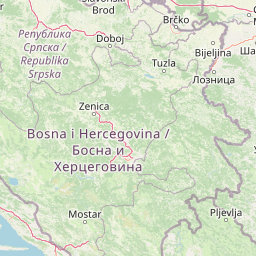
Drina National Park Geographic Boundary Map and Spatial Limits
Interactive outline geometry provides immediate spatial context by tracing the physical perimeter of the protected territory. Regional measurements detail the 63.15 square kilometer land area, center coordinates, and latitudinal spans.
- Boundary area
- 63.2 km²
- Boundary perimeter
- 80.6 km
- Northernmost point
- 44.0386° N
- Southernmost point
- 43.9383° N
- Easternmost point
- 19.4117° E
- Westernmost point
- 19.1768° E
- Geographic centre
- 43.9934° N, 19.2778° E
- North–south span
- 11.2 km
- East–west span
- 18.8 km
Terrain and natural features
Explore recorded peaks, gorges, rivers, and springs within the protected mountain landscape.
Drina National Park Mountain Terrain and Named Natural Features
Mountain terrain classifications govern the protected landscape while documenting recorded natural features located within the park boundary. Linked feature cards supply specific names, types, measurements, and spatial relationships for structural geographic exploration.
Selected named natural features
Streams
Crni potok
Peaks
Pogledala
1,125 m
Streams
Gradski potok
Gorges
Klotijevačka klisura
Peaks
Dubrova glava
Environmental setting
Temperate coniferous forests, canyons, and mountain relief profiles
Drina National Park Environmental Classifications and Physical Setting
Recorded mountain relief, canyon formations, and forest classifications form interpretive categories for the physical setting. Linked atlas destinations connect these terrain records to related protected-area profiles.
- Relief
- Mountain
- Water
- Minor water
- Forest cover
- Mostly forested
Landscape features
Mountains · Cliffs · Canyon · Forest
Habitat types
Temperate coniferous forest · Montane forest
Park atlas
Trace the protected landscapes that border Drina National Park and connect its significant river canyon system with adjacent conservation areas.
Discover Protected Areas Near Drina National Park, Exploring Its Canyon Geography and Regional Context
Continue protected area discovery by exploring other national parks and reserves in the broader Drina River basin and surrounding Balkan mountains. Compare Drina National Park's unique canyon landscape and endemic species with nearby park geographies, gaining deeper regional insights into connected conservation and varied terrain.
National parkSerbia
Park boundaries overlap#1 closest
Southeast

Tara National Park: Endemic Flora and Dramatic Dinaric Alps Geography
Discover Serbia's iconic protected mountain landscape and its unique botanical heritage.
Tara National Park is a significant protected area in Serbia, celebrated for its exceptional botanical value and dramatic mountainous terrain. It is the last refuge for Pančić's spruce, a living fossil conifer, and hosts a remarkable diversity of Balkan flora. The park's landscape is defined by steep limestone cliffs, deep river valleys like the Drina canyon, and expansive forest ecosystems, offering a unique geographic study of protected lands. Explore its mapped features and discover a vital conservation area within the Dinaric Alps.
- Area
- 249.92 km²
- Established
- 1981
- IUCN
- II
- Relief
- Mountain
Protected landscapeSerbia
About 41 km away#2 closest
Southeast
Zlatibor Protected Landscape: Explore its Mapped Geography and Unique Alpine Meadows
Discover Dinaric Alps protected terrain and landscape context.
Zlatibor Protected Landscape offers a distinct exploration of mountainous terrain and protected natural areas in Serbia. Situated in the Dinaric Alps, its landscape is defined by rolling upland plateaus, dense coniferous forests, and open alpine meadows, creating a visually rich environment. The park's geography includes notable karst features and extensive cave systems, complemented by the natural boundaries of significant rivers. Delve into the mapped protected area to understand its landscape character, from the highest peak at Tornik to the unique geological formations and the rare endemic pine subspecies, providing a concrete geographic perspective for atlas-based discovery.
- Area
- 0.419 km²
- Established
- 2017
- IUCN
- VI
- Relief
- Mixed relief
Protected landscapeSerbia
About 62 km away#3 closest
East
Ovčar-Kablar Gorge Protected Landscape: Serbia's River Gorge and Monastery Atlas
Explore karst terrain, monastery sites, and mapped river meanders.
Ovčar-Kablar Gorge is a protected landscape in Serbia renowned for its dramatic karst geology and the West Morava river's pronounced meanders. This area offers a unique atlas perspective, highlighting over a dozen historic Serbian Orthodox monasteries nestled within the dramatic canyon setting. The protected landscape reveals a confluence of significant natural features, including karst cliffs and thermal springs, alongside centuries of spiritual heritage, making it a distinct point for geographic discovery and understanding Serbia's mapped natural and cultural resources.
- Area
- 25 km²
- Established
- 2001
- IUCN
- V
- Relief
- Mixed relief
National parkBosnia and Herzegovina
76 km away#4 closest
Southwest

Sutjeska National Park: Bosnia and Herzegovina's Oldest National Park and Primeval Forest Reserve
Explore the mapped geography and protected landscape of this vital Balkan natural area.
Sutjeska National Park, Bosnia and Herzegovina's inaugural national park, protects a dramatic mountainous region defined by primeval forests and its highest peak, Maglić. As a strict nature reserve, Perućica's ancient trees represent a rare ecological treasure within the Balkan landscape. This page offers a detailed look at the park's protected boundaries, its diverse natural terrain, and its significant geographic setting for atlas exploration.
- Area
- 160.52 km²
- Established
- 1962
- IUCN
- II
- Relief
- Mountain
National parkŽabljak
About 88 km away#5 closest
South

Durmitor National Park: Exploring the Dinaric Alps and Tara River Canyon Landscapes
High-altitude mountain geography and glacial plateau systems
Durmitor National Park preserves a unique concentration of limestone peaks, deep river gorges, and eighteen glacial lakes within the northern highlands of Montenegro. This protected area showcases the interplay between the massive Tara River Canyon and the high-elevation Jezerska površ plateau, offering a comprehensive look at the diverse mountain terrain that defines this Dinaric Alpine wilderness.
- Area
- 390 km²
- Established
- 1952
- IUCN
- II
- Relief
- Mountain
National parkMontenegro
About 91 km away#6 closest
South
Durmitor National Park: Geography and Protected Landscape Atlas of Northern Montenegro
Alpine mountain terrain, deep river canyons, and glacial lake ecosystems.
Delve into the geography of Durmitor National Park, a rugged sanctuary in Montenegro that protects spectacular limestone peaks and the dramatic Tara River canyon. This protected area highlights the geological complexity of the Dinaric Alps through its U-shaped valleys, karst features, and diverse alpine meadows that define this significant regional wilderness.
- IUCN
- II
- Relief
- Mountain
- Climate
- Alpine
- Scope
- Terrestrial
Protected landscapeSerbia
About 107 km away#7 closest
Northeast
Kosmaj Protected Landscape: Explore Serbia's Island Mountain Geography and Forests
Mapped terrain, historic monasteries, and biodiversity near Belgrade.
Kosmaj, a unique protected landscape and island mountain, presents a compelling study in regional geography and mapped terrain for atlas enthusiasts. Rising prominently near Belgrade, its landscape is characterized by dense deciduous forests of beech and oak blanketing its steeper slopes, along with distinct peaks like Mali Vis and Goli Vis. This area serves as a vital watershed source and boasts significant biodiversity, offering a rich context for understanding Serbia's natural and historic environments through structured geographic data and map exploration.
- Area
- 0.035 km²
- Established
- 2005
- IUCN
- V
- Relief
- Lowland
National parkKolašin Municipality
114 km away#8 closest
South
Biogradska Gora National Park: Mountain Geography and Old-Growth Forest Map Exploration
Protected wilderness in the Bjelasica mountain range of central Montenegro
Biogradska Gora serves as a vital protected area in Montenegro, characterized by its sprawling Bjelasica ridges, six distinct glacial lakes, and primeval beech ecosystems. The park terrain offers an expansive look at Balkan high-mountain geography, ranging from deep forested valleys to alpine meadows and peaks exceeding 2,000 meters in elevation.
- Area
- 54 km²
- Established
- 1952
- IUCN
- II
- Relief
- Mountain
MoriAtlas Explorer
Continue Exploring Drina National Park's Mapped Landscape and Regional Geography
Deepen your understanding of Drina National Park by examining its specific geographic features and protected area boundaries. MoriAtlas facilitates exploration of its canyon terrain, endemic ecosystems, and its role within the wider Balkan landscape, providing structured data for geographic discovery.
Browse next
Global natural geography
Explore related park routes
Explore MoriAtlas Global ParksBrowse All MoriAtlas ParksGlobal Park Map DiscoveryMoriAtlas: Browse All CountriesBrowse All MoriAtlas ContinentsNational Park Environment AtlasGrand Canyon National Park AtlasYellowstone National Park AtlasYosemite National Park Atlas and GeographySerengeti National Park AtlasGalápagos National Park Protected LandscapeBanff National Park Geography and AtlasKruger National Park Atlas EntryUluṟu-Kata Tjuṯa National Park AtlasExplore Uluru-Kata Tjuta National Park GeographyPlitvice Lakes National Park AtlasFiordland National Park Protected LandscapeGreat Smoky Mountains National Park AtlasAfghanistan National Parks and Protected AreasAlbania National Parks and Protected AreasAlgeria National Parks and Protected AreasAmerican Samoa National Parks and Protected AreasAndorra National Parks and Protected AreasAngola National Parks and Protected AreasAntarctica National Parks and Protected AreasAntigua and Barbuda Park List