
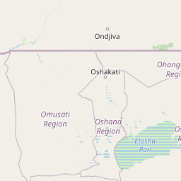
Viewpoints
Park geography
Analyzing the arid terrain, regional landscape features, and protected area boundaries.
Comprehensive Geographic Profile and Mapped Boundaries of Etosha National Park in Namibia
Etosha National Park encompasses 22,270 square kilometers within the Kunene Region of Namibia. This geographic profile details the park's structural savanna and desert landscapes, documenting major waterhole features such as Chudob, Ngobib, and Okerfontein. The data outlines the environmental classification and spatial extent of the protected territory.
Related tags
salt pansavannabig fiveblack rhinodesert wildlife
Vast Namibian savanna reserves built around one of Africa's largest salt pans, sheltering iconic wildlife including the world's largest black rhino population
Etosha National Park
Etosha National Park is a sprawling protected area in northwestern Namibia that ranks among the largest national parks on the African continent. The park was originally proclaimed as a game reserve in March 1907 during German colonial rule, making it one of Africa's oldest protected areas. Its defining feature is the enormous Etosha pan, a vast salt flat spanning approximately 4,760 square kilometers that dominates the park's geography and gives the reserve its distinctive character. The park encompasses a diverse landscape of savanna woodlands, thorn bush plains, and dolomite hills, supporting an remarkable concentration of wildlife despite the harsh desert environment. Etosha holds particular global significance as the single-most important sanctuary for the endangered black rhinoceros, and it provides refuge for hundreds of species of mammals, birds, and reptiles within its boundaries.
- Location
- Namibia
- Park type
- National park
- Established
- 1907
- Area
- 22,270 km²
Location overview
National and regional placement within the Kunene Region
Geographic Location of Etosha National Park in Namibia
Etosha National Park is situated within Namibia, intersecting the Kunene Region. Geographic records indicate that the park operates as a single country inland reserve with no marine or coastal boundaries.
- Countries
- Namibia
- Regions
- Kunene Region
- Primary location
- Kunene Region
- Geographic setting
- Inland
Boundary and coordinates
Spatial data and land area measurements across 22,270 square kilometers
Etosha National Park Geographic Boundaries and Spatial Limits
Interactive boundary outlines provide crucial spatial context and define the geographic orientation of the protected wilderness. Detailed geographic metrics highlight the total land area, coordinate spans, and calculated center points.
- Boundary area
- 22,904.7 km²
- Boundary perimeter
- 824.9 km
- Northernmost point
- 18.4997° S
- Southernmost point
- 19.487° S
- Easternmost point
- 17.1513° E
- Westernmost point
- 14.3532° E
- Geographic centre
- 18.9461° S, 15.8976° E
- North–south span
- 109.3 km
- East–west span
- 294.6 km
Terrain and natural features
Explore mixed terrain classifications and internal water points
Etosha National Park Terrain and Named Natural Features
Etosha National Park features a mixed relief classification alongside recorded interior waterholes, pans, and lakes. Linked feature cards supply type designations and spatial relationships for each recorded natural landmark.
Selected named natural features
Viewpoints
Renosterflei (man-made water point)
Viewpoints
Miernes (man made waterhole)
Lakes
Fisher's Pan
Rivers
Nipele
Viewpoints
Kalkheuwel (man-made water point)
Environmental setting
Arid climate profiles, mixed relief terrain, and seasonal water dynamics.
Etosha National Park Environmental Settings and Mapped Habitat Classifications
Recorded landscape features and habitat types provide complementary ways to read the physical setting of Etosha National Park. Stored environmental classifications connect directly to relevant atlas destinations and regional geography records.
- Relief
- Mixed relief
- Climate
- Arid
- Water
- Major water bodies
- Forest cover
- Mostly forested
- Seasonality
- Strongly seasonal
Landscape features
Karst · Desert · Hills · Woodland · Grassland · Wetland
Habitat types
Savanna · Shrubland · Grassland · Desert habitat · Karst habitat · Wetland · Boreal forest
Park atlas
Map nearby protected areas and trace the regional geography surrounding Etosha National Park, comparing diverse landscapes and conservation value.
Discover Other National Parks and Protected Areas Near Etosha National Park
Continue your exploration from Etosha National Park by browsing other national parks and protected areas within its regional context, revealing distinct ecological zones and conservation landscapes. Comparing these mapped geographies provides valuable insights into the broader environmental diversity and the interconnected efforts protecting Africa's significant natural heritage.
Wildlife reserveOshana Region
About 55 km away#1 closest
North

Oshana-System Wildlife Reserve: Mapping the Seasonal Wetlands of the Oshana Region
A complex network of drainage channels and savanna grasslands
The Oshana-System functions as an expansive inland wetland complex, defined by its flat, sandy terrain and cyclic flooding. This wildlife reserve spans significant portions of north-central Namibia, offering a distinct study in low-gradient hydrology and savanna-wetland transitions characterized by mopane woodland and makalani palms.
- Area
- 30,000 km²
- Relief
- Lowland
- Scope
- Terrestrial
- Water
- Water-dominated
National parkNamibia
109 km away#2 closest
Southeast
Waterberg Plateau Park: A Detailed Atlas of a Protected Table Mountain in Namibia
Geographic overview of the Kalahari plateau ecosystem and protected wilderness
Waterberg Plateau Park offers a deep look into one of Namibia's most recognizable natural landmarks, featuring a classic table mountain formation that rises dramatically from the savannah. This protected area provides a rich study of geological heritage, including ancient strata and isolated plateau ecosystems that support a wide range of bird species and rare fauna. The park serves as a foundational site for conservation, marking a contrast between the elevated plateau and the expansive plains below.
- Area
- 405 km²
- Established
- 1972
- IUCN
- II
- Relief
- Highland
National parkNamibia
About 116 km away#3 closest
Southeast
Waterberg Plateau Park: Mapped Geography and Protected Landscape Identity in Namibia
Central Namibia's ancient plateau and savanna terrain.
Waterberg Plateau Park stands as a defining geological feature of the Namibian landscape. This national park is centered on a dramatic table mountain that creates a distinct ecological island above the surrounding Kalahari basin. Renowned for its ancient rock formations and successful conservation efforts, the area provides a vital protected boundary for endangered species and a significant focus for regional geographic exploration.
- Area
- 405 km²
- Established
- 1972
- IUCN
- II
- Relief
- Mixed relief
National parkNamibia
123 km away#4 closest
West
Skeleton Coast National Park: Namibia's Remote Desert-Coast National Park Exploration
Mapped landscape, shipwrecks, and profound geographic isolation.
Delve into the Skeleton Coast National Park, a monumental protected area in Namibia defined by its stark desert and ocean interface. This page provides detailed geographic context for the park's vast expanse, highlighting its characteristic shipwrecks and the dramatic landscape where towering sand dunes confront the cold Atlantic. Understand the unique protected-area identity of this legendary coastal wilderness through its mapped features and remote setting.
- Area
- 16,845 km²
- Established
- 1971
- IUCN
- II
- Relief
- Lowland
Wildlife reserveOtjozondjupa
About 160 km away#5 closest
South
Okonjati Game Reserve: Mapped Protected Landscapes and Wildlife Geography in Namibia
Ecological terrain and historical mountain setting in Otjozondjupa.
Situated in the heart of Namibia, Okonjati Game Reserve represents a significant private conservation effort centered on the Etjo massif. This 360 square kilometer protected landscape features a blend of rocky uplands and savanna plains, providing a unique habitat for rhinoceroses, elephants, and hippopotamuses while preserving fossilized dinosaur tracks and modern historical landmarks.
- Area
- 360 km²
- Established
- 1975
- Relief
- Upland
- Climate
- Arid
National parkNamibia
183 km away#6 closest
South
Dorob National Park: Namibia's Expansive Coastal Desert and Protected Bird Habitat
Explore mapped landscapes and regional geography.
Dorob National Park is a prime example of a protected coastal desert landscape, stretching along Namibia's Atlantic coast. This national park is renowned for its significant bird populations, making it an Important Bird Area with extensive mapped habitats supporting diverse species. Understand the park's geographic context, from its dramatic dunes to its ephemeral river systems, and its role as a key conservation area within the region.
- Area
- 107,540 km²
- Established
- 2010
- IUCN
- II
- Relief
- Lowland
National parkNamibia
About 209 km away#7 closest
East
Mangetti National Park: Protected Landscape and Geographic Atlas in Namibia
Explore mapped boundaries within Namibia's arid terrain.
Mangetti National Park serves as a crucial protected area, offering insights into Namibia's unique geography and conservation landscapes. Delve into the mapped extent of this national park, understanding its specific location and its contribution to the atlas of protected lands in southern Africa. Examine its geographic character and the context it provides for appreciating the country's natural heritage.
- Area
- 420 km²
- Established
- 2008
- IUCN
- II
- Relief
- Lowland
National parkNamibe Province
228 km away#8 closest
Northwest

Iona National Park: Mapped Protected Landscape in Namibe Province, Angola
Explore the geographic extent and regional context of this national park.
Iona National Park stands as a protected natural area within the administrative region of Namibe Province, Angola. This atlas-focused entry provides detailed insights into the park's mapped boundaries, its regional geographic positioning, and its role as a conservation landscape. Users can engage with specific data to understand the terrain and protected land distribution within this significant Angolan national park.
- Area
- 15,200 km²
- Established
- 1964
- IUCN
- II
- Relief
- Mixed relief
MoriAtlas Explorer
Continue Exploring Etosha National Park's Protected Landscape and Geography
Deepen your understanding of Etosha National Park by examining its specific geographic features and protected area context within the Kunene Region. MoriAtlas provides a structured approach to exploring such vital national parks, offering insights into their landscape's mapped boundaries and their significance in the broader atlas of conservation lands. Continue your geographic discovery by delving into the detailed landscape information available for Etosha National Park.
Browse next
Global natural geography
Explore related park routes
Explore MoriAtlas Global ParksBrowse All MoriAtlas ParksGlobal Park Map DiscoveryMoriAtlas: Browse All CountriesBrowse All MoriAtlas ContinentsNational Park Environment AtlasGrand Canyon National Park AtlasYellowstone National Park AtlasYosemite National Park Atlas and GeographySerengeti National Park AtlasGalápagos National Park Protected LandscapeBanff National Park Geography and AtlasKruger National Park Atlas EntryUluṟu-Kata Tjuṯa National Park AtlasExplore Uluru-Kata Tjuta National Park GeographyPlitvice Lakes National Park AtlasFiordland National Park Protected LandscapeGreat Smoky Mountains National Park AtlasAfghanistan National Parks and Protected AreasAlbania National Parks and Protected AreasAlgeria National Parks and Protected AreasAmerican Samoa National Parks and Protected AreasAndorra National Parks and Protected AreasAngola National Parks and Protected AreasAntarctica National Parks and Protected AreasAntigua and Barbuda Park List