Mori Atlas logo
Nature reserveGhizil-Agaj State Reserve

Mapping the coastal lagoons, marshland terrain, and semi-desert fringes of Azerbaijan

Ghizil-Agaj State Reserve: A Comprehensive Geographic Overview of Caspian Protected Wetlands

Ghizil-Agaj State Reserve serves as a significant protected wetland complex situated along the southwestern shores of the Caspian Sea within the Lankaran District. This expansive nature reserve encompasses a diverse array of aquatic landscapes, including shallow bays, salt flats, reedbeds, and coastal scrub that support migratory bird patterns across the South Caucasus region. The terrain offers a distinct mosaic of environments where river-fed deltas and saline marshes shape the regional ecology.

wetland reserveCaspian coastmigratory birdswaterfowlbirdwatchingRamsar site

Ghizil-Agaj State Reserve

Nature reserve

Park overview

Structured park overview, official facts, and landscape profile for Ghizil-Agaj State Reserve

Ghizil-Agaj State Reserve park facts, protected area profile, and essential visitor context

Review the core facts for Ghizil-Agaj State Reserve, including designation, size, terrain, visitor scale, habitats, and operating context in one park-focused overview.

About Ghizil-Agaj State Reserve

Ghizil-Agaj State Reserve sits at the meeting point of the Caspian Sea, the Kür-Araz lowland, and the Lankaran lowland, a transitional geography that combines open water, coastal lagoons, reed-lined marshes, and arid steppe-like zones. Geography, hydrology, and climate vary across the reserve, with the northern portion under a temperate to mild warm climate and the southern portion experiencing drier and warmer arid conditions. The shorelines of the Greater and Lesser Ghizil-Agaj bays and the connecting coastal belt form the core of the protected area, and approximately half of the reserve's territory consists of aquatic surface.

The reserve was created specifically to safeguard the conditions needed for migratory, wetland, and wild birds to winter, rest, and nest, a purpose that remains central to its identity. It is today the largest of Azerbaijan's state reserves and one of the most ecologically important protected wetland complexes in the South Caucasus. Together with the adjacent Lesser Ghizil-Agaj State Nature Protected Area, which covers an additional ten thousand seven hundred hectares, it forms a wider landscape of bays, river deltas, salt flats, reedbeds, and coastal scrub that together support waterfowl, waders, raptors, and a notable fish fauna.

Ecologically, the reserve functions as a major node on broader flyways linking breeding grounds in Western Siberia, Kazakhstan, the Southern Urals, and Northern Europe with wintering sites further south. This combination of geographic position, habitat diversity, and long-standing protection has made Ghizil-Agaj one of the cornerstones of Azerbaijan's nature conservation system.

Quick facts and research context for Ghizil-Agaj State Reserve

Ghizil-Agaj is the largest state reserve in Azerbaijan by area and the third oldest reserve in the country, originally established in 1929. It lies on the southwestern Caspian coast near Lankaran and covers a combined area of wetlands, shallow bays, salt flats, reedbeds, and semi-desert transitions. It was included in the UNESCO Ramsar list of internationally important wetlands first in 1976 during the Soviet period and again in 2001 after Azerbaijan joined the convention independently.

Protection and recognition

Examine the designated protection history and management scope of Ghizil-Agaj State Reserve.

Ghizil-Agaj State Reserve Protection Status and International Recognition

Ghizil-Agaj State Reserve holds a documented mixed protection status established in the year 2001. Records compile official designation history and management scope for thorough conservation analysis.

Protection details

Protection scope
Mixed
Designated year
2001
Transboundary protection
No
Park context

Deeper park guide and search-rich context for Ghizil-Agaj State Reserve

Ghizil-Agaj State Reserve history, landscape, wildlife, and travel context

Explore Ghizil-Agaj State Reserve through its history, landscape character, ecosystems, wildlife, conservation priorities, cultural context, and seasonal travel timing in a structured park guide built for atlas discovery and search intent.

Why Ghizil-Agaj State Reserve stands out

The reserve is especially known for its extraordinary birdlife. Roughly two hundred and fifty species of water, marsh, and field birds have been recorded there, and most of the bird species listed in Azerbaijan's Red Book are found within its boundaries or adjacent areas. Its flamingos, pelicans, swans, cranes, red-breasted geese, imperial eagles, and sociable lapwings give the wetland an outsized international profile for bird conservation along the Caspian flyway.
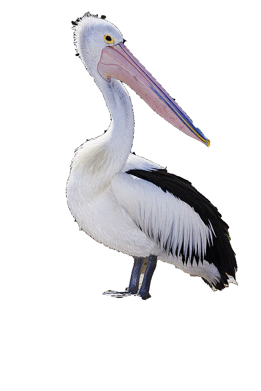
A full body view of an Australian pelican against a solid black background, showing its white body, black wing feathers, and long, pale pink bill.
An Australian pelican, a species often observed in wetland reserves.

Ghizil-Agaj State Reserve history and protected-area timeline

Ghizil-Agaj was established on July 3, 1929, by the Committee on Protection of the Ancient and Art Monuments of Azerbaijan, covering an initial area of eight hundred eighty-four square kilometers on Ghizil-Agaj Bay at the southwestern Caspian coast. It was created with a clear bird-focused mandate: protecting migrant, swamp, and wild birds and providing conditions for their wintering and nesting. From the outset it stood among the earliest and most ambitious reserves in the country, and it remains the largest by area and the third oldest by year of establishment.

The reserve's international profile grew significantly when it was added to the UNESCO list under the convention on internationally important swampy areas as birds' residing places during the Soviet era in 1976. After Azerbaijan declared independence and joined the Ramsar convention in its own right, the site was re-entered on the list of internationally important wetlands in 2001, reinforcing its position as a wetland of enduring global concern.

Ghizil-Agaj State Reserve landscape and geographic character

The landscape of Ghizil-Agaj is defined by the shallow bays and lagoons of the southwestern Caspian Sea, framed by the broader Kür-Araz and Lankaran lowlands. The protected area encompasses the northern parts of the Greater Ghizil-Agaj and Lesser Ghizil-Agaj bays, along with their associated coastal strips, creating a mosaic of open water, sheltered inlets, coastal salt flats, reedbeds, and low scrubby vegetation. About half of the reserve's surface consists of aquatic area, including lakes and marshes along the coast.

Rivers such as the Kür and Vilashchay influence the wetland's hydrology, feeding delta and coastal zones and reinforcing the seasonal rhythm of flooding, drying, and refill. The terrain transitions from water-dominated landscapes in the north to drier, more semi-desertlike conditions toward the south, where gray-meadow and meadow-marsh soils fringe salt-affected coastal flats. The reserve's overall surface vegetation is comparatively modest, but the edges of bays, marshy rises, and salt flats are densely covered by reeds and shrubs that shape the habitat's character.
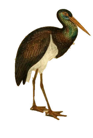
A vintage-style illustration of a black stork with dark iridescent plumage, a white underbelly, and a long orange beak, set against a solid black background.
A detailed historical illustration of a black stork.

Ghizil-Agaj State Reserve ecosystems, habitats, and plant life

Ecologically, Ghizil-Agaj is a mosaic of aquatic, marshland, salt-flat, and semi-desert ecosystems compressed into a relatively narrow coastal belt. The combination of shallow Caspian bays, reed-covered marshlands, and drier shrubby uplands gives the reserve unusually high habitat diversity for a relatively low-lying coastal reserve.

The bay shorelines and salt-affected soils support dense reed and shrub communities, which together with surrounding wetland and dry steppe create distinct foraging, roosting, and shelter zones for birds. The reserve's geographic position, where two major lowlands meet the Caspian, stabilizes the area as a refuge for both resident and visiting species, including many of the waterfowl, waders, and raptors that define the region's conservation significance.
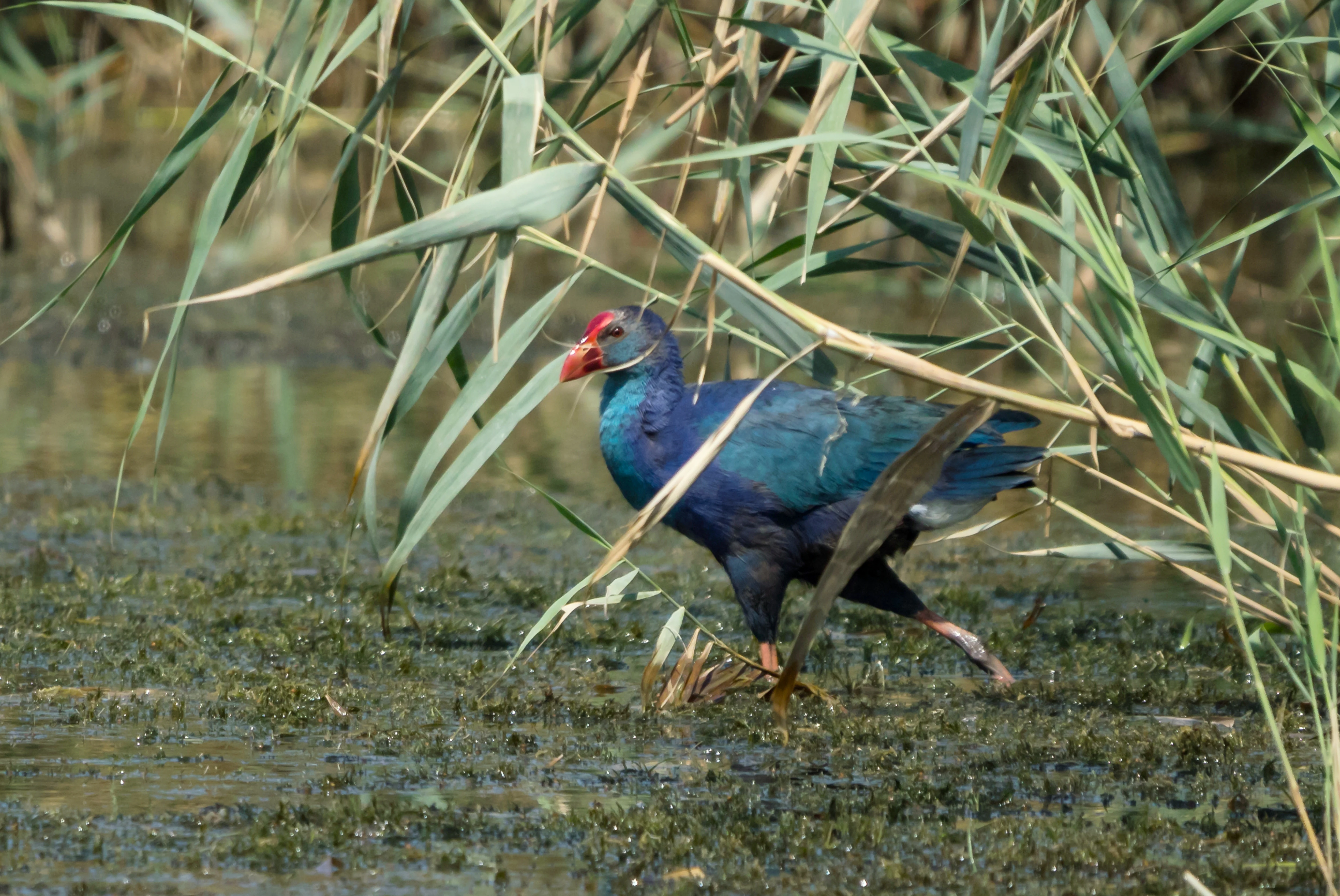
A grey-headed swamphen with bright blue plumage and a red beak walks through shallow water amidst tall marsh grass.
A grey-headed swamphen navigating the marshy wetlands of the Ghizil-Agaj State Reserve.

Ghizil-Agaj State Reserve wildlife and species highlights

Wildlife is the dominant reason the reserve exists, and its bird fauna is the most important dimension. The reserve supports around two hundred and fifty species of water, marsh, and field birds, with most of those listed in Azerbaijan's Red Book found either within the reserve or just outside its boundaries. Greater and Dalmatian pelicans, mute and Bewick's swans, red-breasted geese, greater flamingos, white-tailed and Eastern imperial eagles, golden eagles, black storks, white-tailed and sociable lapwings, great and little bustards, marbled ducks, Eurasian spoonbills, grey-headed swamphens, black francolins, and collared pratincoles all feature among the important species recorded here.

Mammals present in and around the reserve include wild boar, wolf, jungle cat (referred to locally as a reed cat), badger, sable, and fox, with gazelle and otter also documented in regional descriptions of local fauna. The reserve's waters are inhabited by roughly fifty-four fish species, including sturgeon, Caspian kutum, common carp, wels catfish, clupea, sander (perch-like species), common bream, and flathead grey mullet, enriching both the food web and the regional fisheries heritage linked to the Caspian coast.
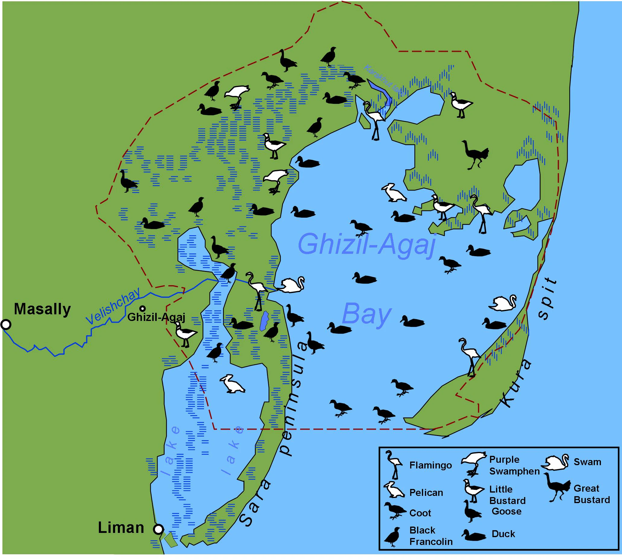
A digital map showing the Ghizil-Agaj State Reserve in Azerbaijan, including the Ghizil-Agaj Bay, Sara Peninsula, and Kura spit, with various bird icons representing species like flamingos, pelicans, and swans.
Map of the Ghizil-Agaj State Reserve showing its geographic boundaries and the various bird species present in the area.

Ghizil-Agaj State Reserve conservation status and protection priorities

Ghizil-Agaj occupies a recognized place in international wetland conservation. It is registered under the Ramsar convention, the global framework for wetlands of international importance, first through a Soviet-era inscription in 1976 and again through an independent Azerbaijani inscription in 2001. Its Ramsar designation has highlighted the reserve's role as a wintering ground for large numbers of migratory waterfowl and as habitat for many species listed in Azerbaijan's Red Book.

The reserve's conservation importance lies in the convergence of several elements: extensive Caspian bays and marshlands, a position on major migratory flyways, documented presence of globally and regionally threatened species, and long-standing state protection since 1929. Its combination of high biodiversity, large area, and Ramsar status makes it a key reference site for wetland conservation policy in Azerbaijan and the wider South Caucasus.

Top sights and standout views in Ghizil-Agaj State Reserve

Ghizil-Agaj is notable for combining exceptional scale with high ecological diversity, encompassing Caspian bays, marshland, salt flats, and semi-desert transitions within a single reserve. Its designation as a Ramsar wetland in 1976 and again in 2001 anchors its international importance, while its approximately two hundred and fifty recorded bird species give it real weight on the Caspian flyway.

The reserve is also distinguished by its proximity to the Lankaran region of Azerbaijan, where the Hyrkanian forests meet Caspian wetlands, and by the cultural memory of the area expressed in the reserve's appearance on a Soviet-era postal stamp dedicated to the Egyptian vulture and the wider protected landscape.
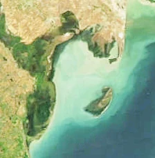
An overhead satellite view showing the coastline, shallow bay waters, and land areas of the Ghizil-Agaj State Reserve along the Caspian Sea.
Satellite view of the Ghizil-Agaj Bay, a significant wetland and marine area within the Ghizil-Agaj State Reserve.

Best time to visit Ghizil-Agaj State Reserve

Because Ghizil-Agaj's identity is shaped by bird movements, the most ecologically significant times to experience the reserve are the autumn arrival and wintering period, when geese, ducks, swans, cranes, pelicans, and flamingos reach the Caspian bays after migrating from Western Siberia, Kazakhstan, the Southern Urals, and Northern Europe. The warmer months can also produce breeding activity for resident marshland and steppe birds, supported by the reserve's vegetable cover and habitat structure.
Monthly climate preview

Long-term representative point measurements for monthly temperature and precipitation variation

Ghizil-Agaj State Reserve Climate Normals and Annual Temperature Rhythm

Ghizil-Agaj State Reserve exhibits a measured annual cycle spanning from cooler winter baseline averages to warm summer peaks alongside distinct monthly precipitation shifts. Examining the complete twelve-month record provides deeper clarity on long-term temperature distributions and regional weather patterns.
Annual mean15 °C
5 °C26 °C
Jan
Feb
Mar
Apr13°
May19°
Jun24°
Jul26°
Aug26°
Sep22°
Oct17°
Nov11°
Dec
Warmest month
July

26.2 °C

Coolest month
January

5.2 °C

Wettest month
October

3.1 mm/day

Driest month
July

0.4 mm/day

Park location guide

Geography guide, regional context, and park location map for Ghizil-Agaj State Reserve

Ghizil-Agaj State Reserve park geography, regions, and map view in Azerbaijan

Understand where Ghizil-Agaj State Reserve sits in Azerbaijan through a broader geographic reading of the surrounding landscape, nearby location context, and its mapped position within the national park landscape.

How Ghizil-Agaj State Reserve fits into Azerbaijan

Azerbaijan is a unitary semi-presidential republic and one of six independent Turkic states. It declared independence from the Soviet Union in 1991 after nearly seven decades of Soviet rule. The country occupies 86,600 km² and has a population of approximately 10.3 million. It is known for its strategic location at the crossroads of Europe and Asia, its oil industry heritage, and its diverse cultural influences from Persian, Russian, and Turkic traditions.

Wider geography shaping Ghizil-Agaj State Reserve in Azerbaijan

Azerbaijan occupies the eastern portion of the Caucasus region, situated between the Caspian Sea to the east and the Greater Caucasus mountains to the north. The terrain is diverse, featuring lowlands along the Caspian coast, mountainous areas in the north and west, and semi-desert plains in the central regions. The Kura and Aras rivers are major waterways draining into the Caspian Sea.

Map view of Ghizil-Agaj State Reserve

Use this park location map to pinpoint Ghizil-Agaj State Reserve in Azerbaijan, understand its exact geographic position, and read its mapped placement within the surrounding landscape more clearly.

Pigeon | © OpenStreetMap contributors

Location context for Ghizil-Agaj State Reserve

Lankaran District

Examine coastal lagoons, wetland habitats, and Caspian scenery across the protected area.

Ghizil-Agaj State Reserve Photos and Visual Landscape Exploration

Visual documentation reveals the diverse terrain, shallow bays, and salt flats that define the wetland sanctuary of Ghizil-Agaj State Reserve. Photographic records offer clear insight into the fragile coastal habitats and migratory bird environments maintained along the Caspian shore.

A full body view of an Australian pelican against a solid black background, showing its white body, black wing feathers, and long, pale pink bill.

A close-up, side-profile view of an Eastern Imperial Eagle with brown and white mottled feathers, a sharp hooked beak, and intense eyes.

A vintage-style illustration of a black stork with dark iridescent plumage, a white underbelly, and a long orange beak, set against a solid black background.

A grey-headed swamphen with bright blue plumage and a red beak walks through shallow water amidst tall marsh grass.

A digital map showing the Ghizil-Agaj State Reserve in Azerbaijan, including the Ghizil-Agaj Bay, Sara Peninsula, and Kura spit, with various bird icons representing species like flamingos, pelicans, and swans.

A full-body studio-style portrait of a red-breasted goose with its distinctively patterned brown, black, and white plumage against a solid black background.

An overhead satellite view showing the coastline, shallow bay waters, and land areas of the Ghizil-Agaj State Reserve along the Caspian Sea.

A close up view of a great white pelican featuring its large bill and white plumage against a solid black background.

A black and white line drawing of a standing gazelle on a solid black background.

A black and white ink style illustration of a wild boar shown in profile facing left against a black background.

Park atlas

Compare adjacent coastal wetlands, lowland reserves, and protected habitats across the region.

Other Parks Near Ghizil-Agaj State Reserve: Exploring Regional Protected Landscapes

Browsing parks near Ghizil-Agaj State Reserve reveals connected wetland networks, coastal lagoons, and lowland protected areas along the Caspian basin. Comparing surrounding regional geography provides deeper context for bird migration routes and wetland conservation in the South Caucasus.
National parkAzerbaijan
About 49 km away#1 closest

North

Shirvan National Park: Azerbaijan's Unique Protected Semi-Desert Ecosystem and Geography

Discover the mapped landscape, gazelle habitats, and wetland geography.

Shirvan National Park, located in Azerbaijan's Shirvan Lowland, safeguards a remarkable semi-desert environment situated on a former Caspian Sea floor. This protected area is distinguished by its low-lying terrain, ancient coastal ridges, and dune formations, providing essential habitat for the world's largest concentration of goitered gazelles. Wetlands around Çala Lake also support significant migratory bird populations, making Shirvan a crucial protected landscape for both terrestrial and avian wildlife and a key site for regional geographic study.

Area
543.735 km²
Established
2003
IUCN
II
Relief
Lowland
Nature reserveAzerbaijan
About 56 km away#2 closest

North

Shirvan State Reserve: Nature Reserve and Protected Landscape in Azerbaijan

A detailed look at the Kura-Araxes saline-steppe and wetland geography

Shirvan State Reserve is a strictly protected nature reserve in southeastern Azerbaijan that encompasses a vast saline-steppe and wetland mosaic. The terrain features wind-shaped sand mounds, expansive reedbeds, and the shallow Lake Chala, all of which define the unique Caspian lowland environment. This area provides an essential refuge for migratory waterbirds and serves as a primary site for gazelle conservation efforts in the Kura-Araxes basin.

Area
62.32 km²
Established
1969
Relief
Lowland
Climate
Temperate
Watercolor painting showing rolling green hills, a body of water, and distant mountains
National parkLankaran Rayon
About 59 km away#3 closest

Southwest

Hirkan National Park: Ancient Hyrcanian Forest Protected Area in Lankaran Rayon

Explore mapped boundaries and unique regional geography.

Hirkan National Park stands as a significant protected area in Azerbaijan, renowned for its extensive old-growth Hyrcanian forests. This national park offers a unique window into ancient temperate rainforest ecosystems, featuring remarkable vertical forest zonation and a high concentration of endemic species within the Talysh Mountains and Lankaran Lowland. Its designation as part of the UNESCO World Heritage Hyrcanian Forests underscores its global importance for conservation and atlas-based geographic exploration of unique, relic landscapes.

Area
403.58 km²
Established
2004
IUCN
II
Relief
Mixed relief
A minimalist watercolor painting featuring stylized, soft-colored hills and a light landscape in Gobustan.
Nature reserveAzerbaijan
About 118 km away#4 closest

North

Gobustan State Reserve: Exploring the Ancient Petroglyphs and Mud Volcanoes of Azerbaijan

Semi-desert topography and protected archaeological heritage in the South Caucasus region.

Located near the Caspian shore, Gobustan State Reserve protects a unique convergence of geology and history. The landscape features deep ravines, sandstone outcrops, and active mud cones, creating a desert environment that serves as an essential record of prehistoric human activity and shifting regional climates.

Area
5.372 km²
Established
1966
Relief
Upland
Climate
Arid
National parkAzerbaijan
About 155 km away#5 closest

Northwest

Ag-Gel National Park

Azerbaijan Protected Wetland & Bird Sanctuary

Ag-Gel National Park is a protected wetland significant for migratory birds. Its landscape features a complex lake system and extensive reed beds, making it a vital conservation area in the Caspian region.

Area
179.24 km²
Established
2003
IUCN
II
Relief
Lowland
Watercolor painting of rolling hills, a body of water, and vegetation
National parkBaku
About 175 km away#6 closest

Northeast

Absheron National Park: Coastal Azerbaijan National Park with Caspian Seal Habitats

Explore mapped geography and semi-desert terrain near Baku.

Absheron National Park, located near Baku on the Absheron Peninsula, is a significant national park safeguarding coastal Caspian Sea environments. Its protected landscapes feature semi-arid terrain and are vital for the conservation of Caspian seals and migratory waterbirds. MoriAtlas provides a structured overview of this unique protected area, focusing on its geographic features, ecological importance, and its role as a key national park within Azerbaijan's atlas of natural reserves.

Area
7.83 km²
Established
2005
IUCN
II
Relief
Lowland
National parkAzerbaijan
About 198 km away#7 closest

North

Altyaghach National Park: Azerbaijan's Protected Natural Area & Forested Geography

Explore the mapped boundaries and temperate deciduous forests.

Altyaghach National Park is a key protected area in Azerbaijan, safeguarding a significant portion of the Greater Caucasus's temperate deciduous broadleaved forest ecosystems. Covering over 11,000 hectares, the park is instrumental in preserving biodiversity and restoring natural habitats, notably providing refuge for the rare East Caucasian tur and other protected species. Its landscape, characterized by rolling to steep terrain and diverse forest cover reaching approximately 941 meters in elevation, makes it a representative example of Caucasus mountain conservation within the country.

Area
110.35 km²
Established
2004
IUCN
II
Relief
Mixed relief
Nature reserveZangilan District
About 208 km away#8 closest

West

Basut-Chay State Reserve: Regional Geography and Protected Forest Landscape Atlas

Nature reserve in the Lesser Caucasus of Azerbaijan

Basut-Chay State Reserve protects a significant riverine landscape dominated by centuries-old Oriental plane trees. Located within the Zangilan District, the area showcases a compact ecological gradient featuring alluvial river terraces and steep mountain slopes. This strict nature reserve provides a essential reference for studying Caucasian floodplain forest remnants and mountain valley topography.

Area
1.07 km²
Established
1974
IUCN
Ia
Relief
Mountain

Common questions about visiting, size, designation, and location context for Ghizil-Agaj State Reserve

Ghizil-Agaj State Reserve FAQs for park facts, access, geography, and protected area context

Find quick answers about Ghizil-Agaj State Reserve, including protected-area facts, park geography, trail and visitor context, and how the park fits into its surrounding country and regional landscape.
MoriAtlas Explorer

Continue Your Protected Areas Search Across the Global Atlas

Deepen your exploration by continuing the structured search for national parks and protected areas worldwide. Utilize the comprehensive filtering capabilities to compare different conservation landscapes and refine your understanding of global park geography. Discover more about the distribution and characteristics of protected natural areas.

Global natural geography