Mori Atlas logo
Nature reserveShirvan State Reserve

Understanding the mapped landscape, gazelle habitats, and wetland mosaic in southeastern Azerbaijan

Shirvan State Reserve: A Strictly Protected Caspian Wetland and Saline Steppe Sanctuary

(Şirvan Dövlət Təbiət Qoruğu)

Shirvan State Reserve serves as a vital ecological sanctuary in the Kura-Araxes basin of southeastern Azerbaijan. This nature reserve protects a distinctive mosaic of saline-steppe terrain, reedbeds, and the shallow waters of Lake Chala, providing a critical refuge for migratory waterbirds and a foundational habitat for gazelle recovery. Beyond its biodiversity significance, the landscape preserves a complex history of geological change and submerged settlements along the Caspian coastal plain.

Caspian lowlandstrict nature reservegazelle habitatwetlandLake ChalaKura-Araxes basin

Shirvan State Reserve

Nature reserve

Park overview

Structured park overview, official facts, and landscape profile for Shirvan State Reserve

Shirvan State Reserve park facts, protected area profile, and essential visitor context

Review the core facts for Shirvan State Reserve, including designation, size, terrain, visitor scale, habitats, and operating context in one park-focused overview.

About Shirvan State Reserve

Shirvan State Reserve occupies a section of the Caspian coastal lowlands in southeastern Azerbaijan, in the Salyan and Neftchala districts along the Kura-Araxes plain. It is a strictly protected area, classified as a Category Ia strict nature reserve under the management of the Ministry of Ecology and Natural Resources of Azerbaijan, and functions as one of the country's most important references for gazelle conservation and Caspian wetland protection.

The reserve's identity sits at the intersection of two major ecological systems: a Caspian-influenced saline steppe, and a wetland complex dominated by Lake Chala and associated reedbeds and canals. Lake Chala covers more than 100 hectares and is very shallow, with dense aquatic plant growth supporting large numbers of migratory waterbirds. The wider reserve additionally includes sandy rises formed by wind action, which are only 0.5 to 1.2 meters tall but provide shelter and concealment for gazelles.

Beyond its ecological role, the reserve has a layer of cultural and historical significance. The area lies below current sea level on land that has been alternately submerged and exposed over geological timescales as Caspian Sea levels have risen and fallen. Within and around the reserve lie the traces of ancient settlements, including the medieval city of Bendovan, that were progressively swallowed by the waters of the Caspian during earlier transgressive phases. Archaeological work has surfaced remains of these lost settlements, and a museum in the associated national park exhibits recovered artifacts. Together these realities position Shirvan State Reserve as a protected area that combines wildlife conservation, wetland ecology, and a distinctive Caspian cultural-landscape story.

Quick facts and research context for Shirvan State Reserve

Shirvan State Reserve is located in the Kura-Araxes lowland of southeastern Azerbaijan, within the Salyan and Neftchala districts. It was established in 1969 on 177 square kilometers taken from the earlier Bendovan State Game Reserve, expanded in 1982, and partly reconfigured when Shirvan National Park was created in 2003.

The reserve sits below sea level on former Caspian seabed, with a mosaic of saline soils, sandy patches, reed-fringed lake margins, and scrub vegetation. Its main water feature is Lake Chala, a shallow, plant-rich wetland that is highly significant for migratory waterbirds in the Caucasus.

Protection and recognition

Documented conservation scope and official recognition framework

Shirvan State Reserve Protection Status and Terrestrial Designation Data

Shirvan State Reserve maintains a defined terrestrial protection status within the regional conservation network. Structured conservation records outline the documented management scope and official designation framework for this protected area.

Protection details

Protection scope
Terrestrial
Transboundary protection
No
Park context

Deeper park guide and search-rich context for Shirvan State Reserve

Shirvan State Reserve history, landscape, wildlife, and travel context

Explore Shirvan State Reserve through its history, landscape character, ecosystems, wildlife, conservation priorities, cultural context, and seasonal travel timing in a structured park guide built for atlas discovery and search intent.

Why Shirvan State Reserve stands out

Shirvan State Reserve is best known as one of Azerbaijan's key protected areas for gazelles, an iconic antelope species that has rebounded strongly within its borders, and as an important Caspian wetland refuge for migratory and wintering waterbirds. The reserve's second signal is its position within the Kura-Araxes saline lowlands, where wind-shaped sand rises, reedbeds, and Lake Chala together form one of the more distinctive wetland- and steppe-mosaic landscapes along Azerbaijan's Caspian coastal plain.
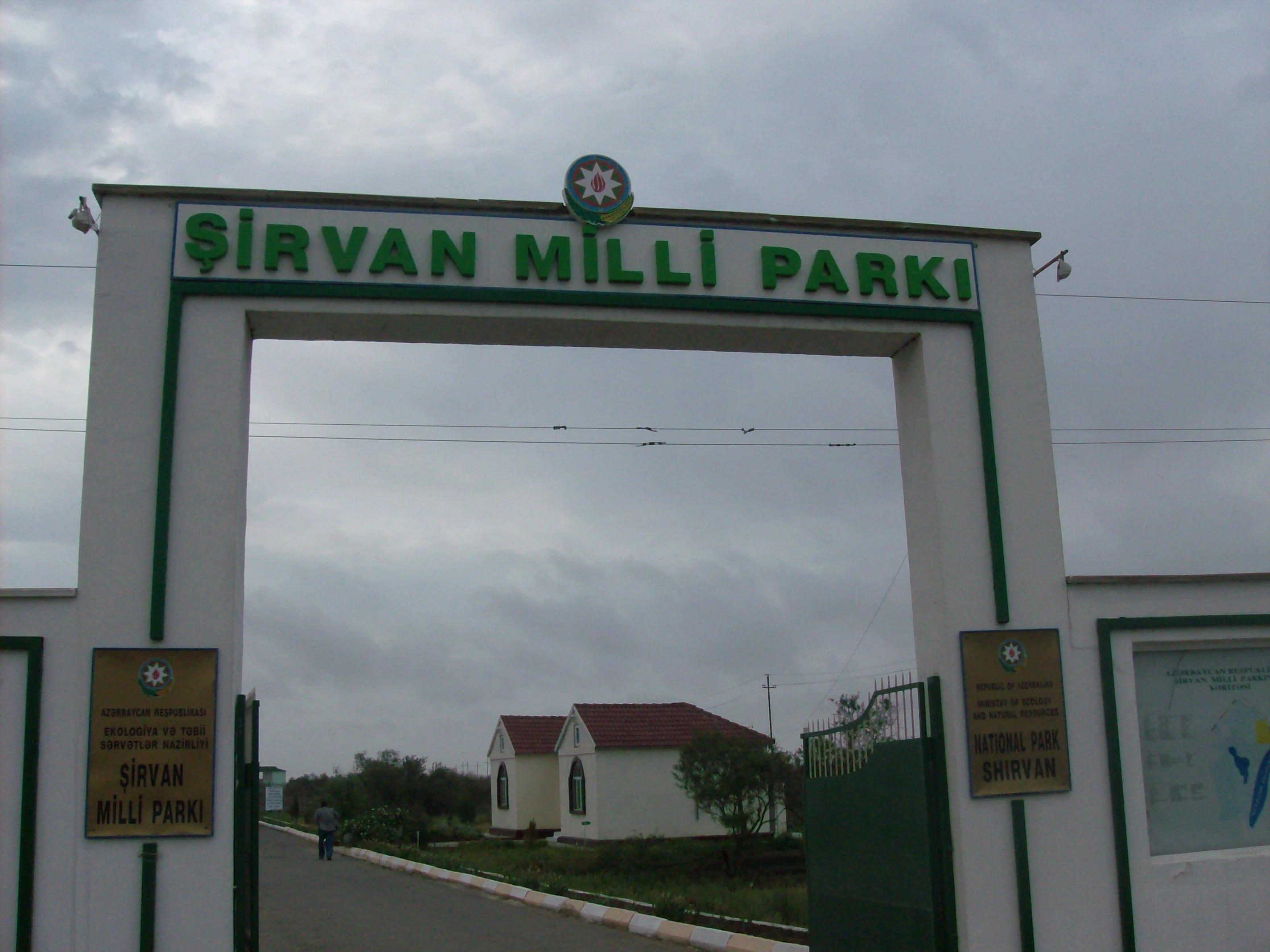
A large concrete archway entrance gate with green text that reads Sirvan Milli Parki, set against an overcast sky.
The main entrance gate to Shirvan National Park.

Shirvan State Reserve history and protected-area timeline

The modern history of Shirvan State Reserve begins with the earlier Bendovan State Game Reserve, a smaller protection regime created in 1961 by special decision of the Azerbaijani government. At that time the local gazelle population had collapsed to just 77 animals.

By 1968 the population within Bendovan had recovered to around 400 gazelles, prompting the government to formally upgrade the area to a full state nature reserve on 30 April 1969. The new reserve covered roughly 17,700 hectares. In 1982 the reserve was significantly enlarged, reaching about 25,761 hectares, to consolidate its protection function across the broader saline-steppe and wetland landscape.

The most consequential later change came in 2003, when the largest portion of the reserve's territory was transferred to the newly created Shirvan National Park. This reorganization reduced the reserve's area again to roughly 6,232 hectares, but it also formalized a two-tier system in which the reserve's stricter IUCN Category Ia status continued to function alongside a broader national park territory that could accommodate public access, education, and conservation outreach.

Shirvan State Reserve landscape and geographic character

The reserve lies in the Caspian lowland of southeastern Azerbaijan, in the Kura-Araxes basin. The terrain is flat to gently undulating and sits at or below current sea level, because the entire area was once part of the Caspian seabed. Repeated fluctuations in sea level over geological time have left a mosaic of marine, fluvial, and alluvial sediments, with grey steppe soils, grey-meadow soils, meadow-marsh soils, and sandy patches.

Micro-relief is clearly visible across the reserve. Wind-shaped sand mounds rise to between roughly 0.5 and 1.2 meters, and although small, they are extremely useful in the landscape, giving gazelles places to hide and rest. Water dominates the picture in the form of Lake Chala, a shallow, plant-rich lake with a depth of about 0.3 to 1.0 meters, plus an extensive network of canals and the broader influence of the nearby Caspian Sea.

Vegetation patterns reflect the saline and wet conditions. Reedbeds grow vigorously in and around the lake, while scrub formations of various kinds break up the open steppe. The combined effect is a continental Caspian lowland ecology where water, salt, sand, and steppe vegetation form a tight, visually distinctive mosaic.

Shirvan State Reserve ecosystems, habitats, and plant life

Ecologically the reserve is structured as a transition between Caspian saline steppe and freshwater wetland. The soils and micro-topography create a matrix in which semi-desert, dry steppe, wet meadow, and true marsh habitats sit beside one another, all within a relatively small area. This habitat diversity underpins the reserve's biodiversity value, especially for species that depend on edges between dryland and wetland.

The lake and its associated wetlands are the main hydrological engine of the reserve. Lake Chala, with its shallow depth and rich aquatic plant growth, supports a substantial population of insects, fish, and amphibians, which in turn sustains rich waterbird communities. The aquatic network also includes reedbeds, channels, and small pools that are critical for migratory species passing through the Caucasus.

The terrestrial side of the reserve is dominated by steppe and semi-shrub communities, with species typical of the Kura-Araxes lowland adapted to saline soils and seasonal aridity. The vegetation pattern gives the reserve its open, mosaic landscape character and is an important habitat element for gazelles and other ground-dwelling wildlife.

Shirvan State Reserve wildlife and species highlights

Wildlife is the central reason the reserve exists. The recovery of the gazelle population is its signature conservation success: from just 77 animals in 1961, to about 400 when the reserve was established in 1969, to roughly 4,800 by 1986, and ultimately to numbers approaching 10,000 animals across what is now the wider Shirevan protected landscape.

The wider mammal fauna of the reserve includes wild boar, wolf, red fox, badger, marsh cat (jungle cat), and hare, in addition to gazelles. Roughly 30 mammal species are recorded across the broader landscape, alongside 22 reptile species and 4 amphibian species.

Birds are the other major wildlife focus. The reserve is described as having very rich ornithological fauna, with documented presence of about 35 bird species across the broader area. Migratory and wintering waterbirds are particularly concentrated around Lake Chala. Notable species highlighted by the reserve's own records include saker falcon, peregrine falcon, houbara bustard, little bustard, and steppe eagle, several of which are listed in Azerbaijan's Red Book of protected species. Reptiles include marsh, Caspian, and Mediterranean tortoises, together with striped lizard, water and land tortoises, and various snake species, while amphibians include garlic-smelling Syrian tree frogs and several other frog species of conservation interest.

Shirvan State Reserve conservation status and protection priorities

Shirvan State Reserve is significant as a long-running case study in ungulate and wetland conservation along the Caspian coast. Its gazelle recovery is a rare conservation success story in the South Caucasus, having shifted the local population from near-extinction toward numbers that now support natural migration outward across Azerbaijan, including documented transfers of animals to support populations in Aggol State Nature Reserve.

The reserve is formally classified in the strictest protection category within Azerbaijan's protected-area system, Category Ia, equivalent to a strict nature reserve under international standards. This means its primary function is ecosystem and species conservation rather than public recreation. Management is overseen by the Ministry of Ecology and Natural Resources of Azerbaijan, with patrol posts and ranger presence around the boundaries to enforce protection and monitor wildlife.

Beyond species protection, the reserve plays a conservation role for Caspian wetland habitat as a whole. Lake Chala and its reedbeds provide refuge for migratory waterbirds along one of the more important flyway corridors of the wider Caucasus-Caspian region. Several of the species protected within its boundaries, including bustards, falcons, tortoises, and a number of reptiles and amphibians, are listed in Azerbaijan's Red Book, which gives the reserve additional standing in national biodiversity protection.

Shirvan State Reserve cultural meaning and human context

The name 'Shirvan' carries deep regional and cultural weight in Azerbaijan, derived from the Persian word 'Shir', meaning lion. Asiatic lions historically occurred across the Trans-Caucasus, including the Shirvan region, before being hunted out by the end of the 10th century, including by local rulers known as shirvanshahs. The reserve's and associated national park's names therefore reflect an older landscape identity tied to big-cat history of the Caucasus.

The reserve also sits within a broader archaeological and cultural landscape shaped by the Caspian Sea. The land itself was repeatedly submerged and exposed over geological time, and remnants of older settlements survive in the form of traces of cities that were progressively swallowed by the sea. Among these is the medieval settlement of Bendovan, located on what is now reserve territory, along with the remains of another city some 10 to 12 kilometers away. Archaeological work and excavations have recovered artifacts from these submerged urban sites, and pieces from them are now displayed in a museum within the associated national park area, with park staff offering visitors interpretive information about this submerged-city heritage alongside the reserve's natural values.

Top sights and standout views in Shirvan State Reserve

The reserve's standout features are the protected Caspian saline-steppe and wetland mosaic, the long-running recovery program for gazelles that now numbers close to 10,000 animals in the broader landscape, and the importance of Lake Chala as a refuge for migratory waterbirds along the Caspian coast. Together these qualities make the reserve one of the most important strict nature reserves in Azerbaijan's protected-area system.

A second highlight layer is the cultural and historical dimension. The reserve's territory contains traces of older settlements engulfed by past Caspian Sea transgressions, including the medieval city of Bendovan, giving the area a visibly layered identity that combines modern biodiversity conservation with the geological and human history of the Kura-Araxes lowland.

Best time to visit Shirvan State Reserve

Because the reserve itself is a strictly protected area with the highest level of protection status, public access is highly limited and managed mostly through guided excursions associated with the broader Shirvan National Park. Visitors considering the wider Shirvan protected landscape will find different seasonal character throughout the year: cooler months tend to bring more comfortable conditions for outdoor excursions, while warmer months coincide with periods when gazelles and other wildlife are more often seen moving in the open landscape and around water sources. Migratory waterbird presence around Lake Chala also varies by season, with cooler months historically playing an important role for wintering flocks along the Caspian coast.
Monthly climate preview

Long-term representative measurements of monthly temperature and precipitation rhythm

Shirvan State Reserve Climate Normals and Annual Temperature Patterns

Shirvan State Reserve exhibits measured annual temperature variations from mean monthly lows of 6.5 degrees to highs exceeding 26 degrees alongside recorded precipitation patterns. Analyzing the complete monthly climate profile reveals detailed twelve-month meteorological statistics for this protected location.
Annual mean16 °C
7 °C27 °C
Jan
Feb
Mar
Apr12°
May18°
Jun23°
Jul26°
Aug27°
Sep23°
Oct19°
Nov13°
Dec
Warmest month
August

26.8 °C

Coolest month
February

6.5 °C

Wettest month
October

2.3 mm/day

Driest month
July

0.3 mm/day

Park location guide

Geography guide, regional context, and park location map for Shirvan State Reserve

Shirvan State Reserve park geography, regions, and map view in Azerbaijan

Understand where Shirvan State Reserve sits in Azerbaijan through a broader geographic reading of the surrounding landscape, nearby location context, and its mapped position within the national park landscape.

How Shirvan State Reserve fits into Azerbaijan

Azerbaijan is a unitary semi-presidential republic and one of six independent Turkic states. It declared independence from the Soviet Union in 1991 after nearly seven decades of Soviet rule. The country occupies 86,600 km² and has a population of approximately 10.3 million. It is known for its strategic location at the crossroads of Europe and Asia, its oil industry heritage, and its diverse cultural influences from Persian, Russian, and Turkic traditions.

Wider geography shaping Shirvan State Reserve in Azerbaijan

Azerbaijan occupies the eastern portion of the Caucasus region, situated between the Caspian Sea to the east and the Greater Caucasus mountains to the north. The terrain is diverse, featuring lowlands along the Caspian coast, mountainous areas in the north and west, and semi-desert plains in the central regions. The Kura and Aras rivers are major waterways draining into the Caspian Sea.

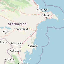
Map view of Shirvan State Reserve

Use this park location map to pinpoint Shirvan State Reserve in Azerbaijan, understand its exact geographic position, and read its mapped placement within the surrounding landscape more clearly.

Pigeon | © OpenStreetMap contributors

Visualizing the Caspian saline lowlands, reedbeds, and wetland mosaic of Azerbaijan.

Shirvan State Reserve Photos: Landscape, Scenery, and Protected Habitats

Visual records capture the distinctive saline steppe, wind-shaped sand mounds, and shallow waters defining the protected environment of Shirvan State Reserve. Photographic documentation reveals the underlying terrain and wetland habitats supporting regional wildlife populations across the Kura-Araxes basin.

A large concrete archway entrance gate with green text that reads Sirvan Milli Parki, set against an overcast sky.

Park atlas

Compare surrounding Caspian lowlands, wetlands, and protected steppe landscapes.

Other Parks Near Shirvan State Reserve and Regional Protected Areas

Browse nearby national parks and protected areas connected to the unique Caspian wetland and saline steppe geography of Shirvan State Reserve. Compare surrounding lowland reserves to understand the wider ecological context of the Kura Araxes basin.
National parkAzerbaijan
About 11 km away#1 closest

Southwest

Shirvan National Park: Azerbaijan's Unique Protected Semi-Desert Ecosystem and Geography

Discover the mapped landscape, gazelle habitats, and wetland geography.

Shirvan National Park, located in Azerbaijan's Shirvan Lowland, safeguards a remarkable semi-desert environment situated on a former Caspian Sea floor. This protected area is distinguished by its low-lying terrain, ancient coastal ridges, and dune formations, providing essential habitat for the world's largest concentration of goitered gazelles. Wetlands around Çala Lake also support significant migratory bird populations, making Shirvan a crucial protected landscape for both terrestrial and avian wildlife and a key site for regional geographic study.

Area
543.735 km²
Established
2003
IUCN
II
Relief
Lowland
Nature reserveLankaran District
About 56 km away#2 closest

South

Ghizil-Agaj State Reserve: Mapping the Caspian Coastal Protected Landscape in Azerbaijan

Regional geography and wetland terrain in Lankaran District

Spanning the shallow inlets of the southwestern Caspian Sea, Ghizil-Agaj State Reserve represents a critical protected wetland area. Its geography is defined by a transition between open water, marshy coastal strips, and salt-affected semi-desert zones. By analyzing the reserve's boundaries and hydrological features, one gains a clearer understanding of how this significant natural landscape functions within the broader environmental context of the South Caucasus.

Area
884 km²
Established
1929
Relief
Lowland
Climate
Subtropical
A minimalist watercolor painting featuring stylized, soft-colored hills and a light landscape in Gobustan.
Nature reserveAzerbaijan
About 62 km away#3 closest

North

Gobustan State Reserve: Exploring the Ancient Petroglyphs and Mud Volcanoes of Azerbaijan

Semi-desert topography and protected archaeological heritage in the South Caucasus region.

Located near the Caspian shore, Gobustan State Reserve protects a unique convergence of geology and history. The landscape features deep ravines, sandstone outcrops, and active mud cones, creating a desert environment that serves as an essential record of prehistoric human activity and shifting regional climates.

Area
5.372 km²
Established
1966
Relief
Upland
Climate
Arid
Watercolor painting showing rolling green hills, a body of water, and distant mountains
National parkLankaran Rayon
About 114 km away#4 closest

South

Hirkan National Park: Ancient Hyrcanian Forest Protected Area in Lankaran Rayon

Explore mapped boundaries and unique regional geography.

Hirkan National Park stands as a significant protected area in Azerbaijan, renowned for its extensive old-growth Hyrcanian forests. This national park offers a unique window into ancient temperate rainforest ecosystems, featuring remarkable vertical forest zonation and a high concentration of endemic species within the Talysh Mountains and Lankaran Lowland. Its designation as part of the UNESCO World Heritage Hyrcanian Forests underscores its global importance for conservation and atlas-based geographic exploration of unique, relic landscapes.

Area
403.58 km²
Established
2004
IUCN
II
Relief
Mixed relief
Watercolor painting of rolling hills, a body of water, and vegetation
National parkBaku
About 130 km away#5 closest

Northeast

Absheron National Park: Coastal Azerbaijan National Park with Caspian Seal Habitats

Explore mapped geography and semi-desert terrain near Baku.

Absheron National Park, located near Baku on the Absheron Peninsula, is a significant national park safeguarding coastal Caspian Sea environments. Its protected landscapes feature semi-arid terrain and are vital for the conservation of Caspian seals and migratory waterbirds. MoriAtlas provides a structured overview of this unique protected area, focusing on its geographic features, ecological importance, and its role as a key national park within Azerbaijan's atlas of natural reserves.

Area
7.83 km²
Established
2005
IUCN
II
Relief
Lowland
National parkAzerbaijan
About 134 km away#6 closest

West

Ag-Gel National Park

Azerbaijan Protected Wetland & Bird Sanctuary

Ag-Gel National Park is a protected wetland significant for migratory birds. Its landscape features a complex lake system and extensive reed beds, making it a vital conservation area in the Caspian region.

Area
179.24 km²
Established
2003
IUCN
II
Relief
Lowland
National parkAzerbaijan
About 144 km away#7 closest

North

Altyaghach National Park: Azerbaijan's Protected Natural Area & Forested Geography

Explore the mapped boundaries and temperate deciduous forests.

Altyaghach National Park is a key protected area in Azerbaijan, safeguarding a significant portion of the Greater Caucasus's temperate deciduous broadleaved forest ecosystems. Covering over 11,000 hectares, the park is instrumental in preserving biodiversity and restoring natural habitats, notably providing refuge for the rare East Caucasian tur and other protected species. Its landscape, characterized by rolling to steep terrain and diverse forest cover reaching approximately 941 meters in elevation, makes it a representative example of Caucasus mountain conservation within the country.

Area
110.35 km²
Established
2004
IUCN
II
Relief
Mixed relief
Watercolor painting of layered mountains with green, yellow, and pink hues.
National parkAzerbaijan
About 165 km away#8 closest

Northwest

Shahdag National Park: Azerbaijan's Largest National Park and Highest Mountain Landscape

Explore the Greater Caucasus protected area and its unique ecosystems.

Shahdag National Park is the largest protected area in Azerbaijan, encompassing a significant portion of the Greater Caucasus mountain range. This national park is renowned for its dramatic elevation changes, creating diverse ecosystems that transition from dense, old-growth montane forests to high-alpine meadows and rugged, rocky summits. The park's landscape is defined by its towering peaks, including Mount Bazardüzü, the nation's highest point, and provides critical habitat for endemic species like the East Caucasian tur. Use this page to begin your atlas-based exploration of Shahdag National Park's protected geography and its distinctive natural terrain.

Area
1,305.08 km²
Established
2006
IUCN
II
Relief
Mountain

Common questions about visiting, size, designation, and location context for Shirvan State Reserve

Shirvan State Reserve FAQs for park facts, access, geography, and protected area context

Find quick answers about Shirvan State Reserve, including protected-area facts, park geography, trail and visitor context, and how the park fits into its surrounding country and regional landscape.
MoriAtlas Explorer

Continue Your Protected Areas Search Across the Global Atlas

Deepen your exploration by continuing the structured search for national parks and protected areas worldwide. Utilize the comprehensive filtering capabilities to compare different conservation landscapes and refine your understanding of global park geography. Discover more about the distribution and characteristics of protected natural areas.

Global natural geography