
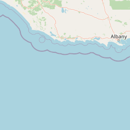
Bays
Park geography
Spatial analysis of coastal terrain, regional boundaries, and protected landscapes
Comprehensive Geographic Profile and Mapped Boundaries of Gull Rock National Park
Examine the detailed geographic structure of Gull Rock National Park, a protected coastal area located in Western Australia. This profile details the park boundary extents, surrounding terrain, and integrated physical landscape features such as Mount Richard, Mount Taylor, and local bays. The dataset provides mapped context for the regional coastal and wetland environment.
Related tags
coastal national parkWestern Australiaheathland ecosystemgranite headlandsbanksia woodland
Coastal reserve protecting southwest Australia's threatened heathlands and granite headlands
Gull Rock National Park
Gull Rock National Park is a compact coastal protected area in the Great Southern region of Western Australia, situated approximately 25 kilometers east of Albany along the southern coastline. Established in 2006 as Western Australia's 97th national park, the reserve encompasses roughly 2,593 hectares of diverse coastal landscapes characterized by granite headlands, sandy beaches, interdunal wetlands, and a complex mosaic of heathland, woodland, and forest ecosystems. The park sits within the eastern arm of the Kalgan River vegetation system, a region recognized for its exceptional biodiversity and the presence of several threatened species. King George Sound borders the southern edge of the reserve, while Oyster Harbour lies to the west and Taylor Inlet to the east, creating a distinctive coastal setting where rocky promontories alternate with sheltered beach corridors and freshwater wetland pockets.
- Location
- Australia
- Park type
- National park
- Established
- 2006
- Area
- 21 km²
Location overview
Coastal protected area boundaries within Western Australia
Geographic Context and Location of Gull Rock National Park in Australia
Gull Rock National Park is located in Western Australia, serving as a regional reserve in Australia. Coastal classification defines its boundaries, which exist entirely within a single country.
- Countries
- Australia
- Regions
- Western Australia
- Primary location
- Western Australia
- Geographic setting
- Coastal
Boundary and coordinates
Mapped spatial footprint and coordinates covering 21.04 square kilometers
Mapped Boundaries and Geographic Extent of Gull Rock National Park
The mapped geographic boundary provides vital spatial context for Gull Rock National Park. Accompanying facts outline the total area of 21.04 square kilometers alongside estimated perimeters, center coordinates, and spatial spans.
- Boundary area
- 21.1 km²
- Boundary perimeter
- 55.7 km
- Northernmost point
- 34.9726° S
- Southernmost point
- 35.0209° S
- Easternmost point
- 118.0535° E
- Westernmost point
- 117.9656° E
- Geographic centre
- 34.9996° S, 118.0098° E
- North–south span
- 5.3 km
- East–west span
- 8 km
Terrain and natural features
Lowland landscape classifications and recorded geographic features
Gull Rock National Park Terrain and Named Natural Features
Gull Rock National Park features recorded lowland terrain classifications alongside named natural landmarks, including Oyster Harbour and Mount Taylor. Linked feature cards provide names, types, measurements, and spatial relationships where recorded.
Selected named natural features
Peaks
Mount Taylor
Peaks
Mount Richard
Beaches
Ledge Beach Road
Beaches
Ben Dearg Beach
Environmental setting
Temperate climate zones, lowland relief, and coastal wetland habitats across the terrain
Gull Rock National Park Environmental Settings and Classification Profile
Stored landscape features, temperate habitats, and water presence provide complementary ways to read the physical setting of Gull Rock National Park. Recorded categories connect directly to related protected areas and regional atlas destinations for structured comparison.
- Relief
- Lowland
- Climate
- Temperate
- Water
- Major water bodies
- Forest cover
- Partial forest
- Seasonality
- Year-round
Landscape features
Coast · Beach · Cliffs · Wetland · Woodland · Islands
Habitat types
Temperate broadleaf forest · Wetland · Coastal habitat
Park atlas
Compare protected coastal landscapes and regional park geography within Australia's Great Southern region.
Explore Other National Parks and Protected Areas Near Gull Rock National Park, Western Australia
Discover additional national parks and protected areas situated around Gull Rock National Park, tracing Western Australia's unique coastal ecosystems and regional conservation efforts. Explore these neighboring reserves to understand the broader spread of protected landscapes, comparing diverse granite headlands, banksia heathlands, and wetland habitats across the Great Southern region.
National parkWestern Australia
7.4 km away#1 closest
Southwest

Torndirrup National Park National Park: Mapped Boundaries and Regional Landscape Context
Explore protected lands within Western Australia's geography.
Torndirrup National Park serves as a significant protected natural area, offering valuable insights into the geographic character of Western Australia. This detailed entry focuses on its mapped boundaries and its role as a protected landscape, providing essential context for atlas-based exploration of Australia's diverse regions and natural terrains.
- Area
- 39.36 km²
- Established
- 1918
- IUCN
- II
- Visitors
- 250K annual
National parkWestern Australia
17 km away#2 closest
Northeast
Waychinicup National Park: National Park Protected Landscape Atlas Entry
Explore Western Australia's mapped natural landscapes and park geography.
Gain a structured understanding of Waychinicup National Park as a key protected landscape within Western Australia. This detailed atlas entry focuses on its geographic distribution and mapped boundaries, providing essential context for regional park and natural landscape exploration. Discover the unique characteristics of this national park's setting and its place within the broader mapped terrain.
- Area
- 39.82 km²
- Established
- 1990
- IUCN
- II
- Relief
- Mixed relief
National parkWestern Australia
27 km away#3 closest
Northeast
Hassell National Park National Park: Mapped Protected Landscape in Western Australia
Explore the geographic identity and park boundaries of Hassell National Park.
Hassell National Park offers a focused view of protected natural landscapes within Western Australia. This atlas entry details the park's specific geographic scope and its designation as a national park, providing essential context for understanding its mapped features and regional landscape. Explore how Hassell National Park contributes to the protected area geography of the state.
- Area
- 12.65 km²
- Established
- 1971
- IUCN
- II
- Scope
- Mixed
National parkWestern Australia
29 km away#4 closest
North
Porongurup National Park: Ancient Granite Peaks and Karri Forest Protected Landscape
Mapped terrain and geologic history in Western Australia.
Delve into Porongurup National Park, a protected landscape in Western Australia characterized by its ancient, billion-year-old granite peaks and a rare outlier of towering karri forest. This national park offers a unique geographic perspective, showcasing dramatic mountain terrain that has stood for eons. Explore the mapped boundaries and the distinct ecosystems that thrive within this ancient mountain system, providing rich context for regional atlas discovery and understanding the park's geological significance.
- Area
- 26.21 km²
- Established
- 1971
- IUCN
- II
- Relief
- Mountain
National parkWestern Australia
30 km away#5 closest
West
West Cape Howe National Park: Western Australia's Southernmost Coastal Protected Landscape
Explore dramatic sea cliffs, ancient karri forests, and Torbay Head.
West Cape Howe National Park offers a distinct protected landscape experience in Western Australia, highlighted by its position at mainland Australia's southernmost point, Torbay Head. This park showcases a rugged 23-kilometer stretch of the Southern Ocean coastline, featuring towering sea cliffs that descend to pristine beaches and rocky shores. Inland, visitors find ancient karri forests and diverse vegetation types, contributing to a rich mosaic of protected habitats. Its geographic significance and unique coastal terrain make it a key destination for understanding regional protected area geography.
- Area
- 36.05 km²
- Established
- 1985
- IUCN
- II
- Relief
- Lowland
National parkGreat Southern
41 km away#6 closest
West
Mount Lindesay National Park: Australian National Park Protected Landscape Details
Explore mapped boundaries and regional geographic context in Great Southern.
Gain a structured understanding of Mount Lindesay National Park, a designated national park in Australia's Great Southern region. This detail view focuses on its protected landscape identity, mapped geographic features, and its place within the nation's network of conservation areas. Discover the specific terrain and regional atlas context that makes this park a distinct element of Australia's natural geography.
- Area
- 395.73 km²
- Established
- 2004
- IUCN
- II
- Relief
- Mountain
National parkWestern Australia
53 km away#7 closest
North
Stirling Range National Park: National Park Protected Area and Geographic Mapping
Discover its mapped boundaries and regional landscape context.
Stirling Range National Park is a protected national park in Western Australia, offering critical insights into regional geography and landscape mapping. This page provides structured information on the park's protected area status, its geographic setting, and its value for atlas-based exploration. Understand the extent of its mapped boundaries and discover its unique natural terrain within the broader context of Western Australia's vast geography.
- Area
- 1,159.2 km²
- Established
- 1913
- IUCN
- II
- Relief
- Mountain
National parkWestern Australia
63 km away#8 closest
West
William Bay National Park: Mapped Protected Area in Western Australia's Geography
Explore its national park boundaries and regional landscape context.
Delve into the protected landscape of William Bay National Park, a designated national park situated within the diverse geography of Western Australia. This resource provides critical information on its mapped boundaries and its role as a protected natural area. Understand the park's specific geographic setting and its contribution to the regional atlas of conservation landscapes, essential for detailed park and landscape discovery.
- Area
- 17.34 km²
- Established
- 1971
- IUCN
- II
- Visitors
- 238K annual
MoriAtlas Explorer
Continue Exploring Gull Rock National Park's Mapped Geography and Protected Landscape
Deepen your understanding of Gull Rock National Park by delving into its specific geographic context and protected landscape features. This national park offers a unique perspective on conservation areas within Western Australia, contributing valuable data for detailed atlas exploration and regional geography analysis. Understand its place within the broader mapped terrain of Australia.
Browse next
Global natural geography
Explore related park routes
Explore MoriAtlas Global ParksBrowse All MoriAtlas ParksGlobal Park Map DiscoveryMoriAtlas: Browse All CountriesBrowse All MoriAtlas ContinentsNational Park Environment AtlasGrand Canyon National Park AtlasYellowstone National Park AtlasYosemite National Park Atlas and GeographySerengeti National Park AtlasGalápagos National Park Protected LandscapeBanff National Park Geography and AtlasKruger National Park Atlas EntryUluṟu-Kata Tjuṯa National Park AtlasExplore Uluru-Kata Tjuta National Park GeographyPlitvice Lakes National Park AtlasFiordland National Park Protected LandscapeGreat Smoky Mountains National Park AtlasAfghanistan National Parks and Protected AreasAlbania National Parks and Protected AreasAlgeria National Parks and Protected AreasAmerican Samoa National Parks and Protected AreasAndorra National Parks and Protected AreasAngola National Parks and Protected AreasAntarctica National Parks and Protected AreasAntigua and Barbuda Park List