Peaks
Festningsnutan
1,368 m

Examining the plateau landscape, elevation range, and mapped protected area boundaries
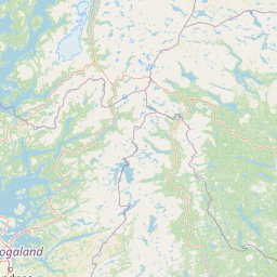
Review the geographic framework of Hardangervidda National Park, spanning 3422 square kilometers across Buskerud, Telemark, and Vestland. This profile details the highland terrain, including significant peaks like Sandfloegga and Hårteigen, alongside complex wetland and alpine meadow systems within the boreal climate zone.
Norway's largest mountain plateau and Arctic wildlife sanctuary
Hardangervidda National Park is Norway's largest national park, encompassing a vast mountain plateau that spans three counties in southern Norway. Covering 3,422 square kilometres, the park protects the Hardangervidda, the largest peneplain in Europe, characterized by barren, treeless moorland, countless lakes, rivers, and pools, and dramatic mountain scenery. The plateau sits at an average elevation of 1,100 metres above sea level and supports one of the most significant Arctic ecosystems on the continent, hosting the southernmost populations of several Arctic animal and plant species. The park is internationally significant for its wild reindeer herds, which are among the largest in the world, and for the hundreds of Stone Age archaeological sites that document millennia of human presence tied to reindeer migration patterns. Established in 1981, the park remains a vital corridor for biodiversity and a beloved destination for hikers, skiers, and nature enthusiasts.
Regional distribution within Buskerud, Vestland, and Telemark
Analyzing the geographic footprint and spatial extent of the protected area
Highland relief profiles, peaks, valleys, and river networks
Peaks
1,368 m
Hills
Hills
1,454 m
Bays
Hills
1,338 m
Rivers
Boreal climate zones, highland relief, and plateau habitats across recorded terrain
Plateau · Hills · Valleys · Grassland · Wetland · Lakes · Rivers · Glacier · Cliffs
Alpine meadow · Grassland · Wetland · Peatland · Riverine habitat · Lacustrine habitat · Tundra habitat
Compare protected areas across Norway's Western Fjords and the expansive mountain plateau geography.
West

Mapped glacial terrain and park boundaries in Vestland.
Folgefonna National Park in Vestland, Norway, stands as a premier protected area defined by its vast ice cap and dramatic glacial geography. This page details the park's mapped boundaries, showcasing its impressive glacial formations, U-shaped valleys, and distinct alpine landscapes. Understand the geographic context and protected status of Folgefonna National Park, a key destination for exploring Norway's glacier heritage through an atlas-driven lens.
North
Mapping glacial terrain, alpine environments, and wild reindeer habitat.
Hallingskarvet National Park offers a unique window into Norway's geological history and alpine ecology. This protected landscape encompasses the striking Hallingskarvet plateau and the Vargebreen glacier, along with deep valleys carved by ancient ice. Users can explore the park's mapped boundaries, understand its regional geographic setting in Scandinavia, and appreciate its conservation value as a habitat for wild reindeer. The park's terrain provides a concrete example of glacial shaping and high-altitude ecosystems within the Nordic context.
East
Mapped terrain of high-lying plateaus, ancient coniferous forests, and wetland mosaic.
Vikerfjell naturreservat serves as a vital protected area for old-growth coniferous forests and vulnerable lichen species. This atlas provides a detailed view of its mountain plateaus, forested slopes, and the expansive mire systems that characterize this key southern Norwegian conservation landscape within the Ringerike municipality.
North
Explore mapped glacial terrain and alpine geography.
Jotunheimen National Park stands as a monument to Norway's alpine grandeur, protecting over 1,151 square kilometers of spectacular mountainous terrain. This protected area is defined by its dramatic glacial features, including sharp peaks exceeding 1,900 meters, U-shaped valleys, and pristine alpine lakes, making it a significant focus for geographic exploration and mapped landscape study. Delve into the core of Norway's mountain heartland, understanding the mapped boundaries and regional geological context that shape this iconic protected landscape.
North
Mapped terrain and protected area discovery in Vestland, Norway.
Jostedalsbreen National Park represents a unique geographic entity, safeguarding the largest glacier on the European mainland. This national park, situated in Norway's Vestland region, offers profound insights into glacial landscapes and mountain geography. Users can explore the vast ice mass that dominates the terrain, observe the U-shaped valleys carved by its movement, and understand the geological processes shaping this dynamic environment. The park's protected status highlights its importance for understanding glacial science and preserving a critical component of Norway's natural heritage.
Northeast
Discover mapped boundaries and regional geographic context.
Langsua National Park, a designation expanded in 2011, is a prominent protected area in Norway's Innlandet county. This national park encompasses 537.1 square kilometers of diverse mountainous terrain, characterized by extensive mountain forests and inland wilderness habitats. Its creation consolidates fragmented nature reserves into a significant contiguous protected landscape, offering valuable insight into Norway's conservation strategies and the geographic context of its eastern mountain regions.
North
Norway's prominent national park featuring active glaciers and alpine geography.
Breheimen National Park represents a significant protected landscape within Norway's Innlandet region, dedicated to conserving its unique glacial formations and dramatic alpine terrain. The park's vast area encompasses active glaciers, soaring peaks, and a notable diversity of natural environments, from lush valleys to barren plateaus. MoriAtlas facilitates a detailed exploration of Breheimen National Park, highlighting its mapped protected boundaries and its integral role in the regional geography and protected areas atlas.
Southeast
Norway's unique marine-focused national park landscape.
Jomfruland National Park is a significant protected landscape in Telemark, Norway, renowned for its coastal island geography and a landscape predominantly composed of marine waters. Covering 117 square kilometers, this national park emphasizes the conservation of both terrestrial island habitats and the surrounding Skagerrak coastal ecosystem. Explore the park's mapped boundaries and discover its regional geographic context, offering a unique perspective on Norway's protected areas and maritime natural heritage through MoriAtlas.
Understanding Hardangervidda National Park is a key step in exploring Norway's protected areas and broader regional geography. Use this atlas entry to grasp the unique mapped context of its arctic plateau, its distinctive treeless terrain, and its ecological significance. Continue your discovery of the Vestland region's natural landscapes and protected lands through MoriAtlas's structured approach to geographic exploration.