
Lakes
Park geography
Analyzing the terrain, river networks, and environmental landscape across 406 square kilometers
Holy Mountains National Nature Park Detailed Geographic Profile and Land Boundaries
This geographic profile tracks the spatial characteristics of Holy Mountains National Nature Park in Donetsk Oblast, Ukraine. The data covers a 406 square kilometer area defined by temperate forests, diverse river systems, and marked elevation points reaching 130 meters. Explore the mapped relationships between protected cliffs, inland lakes, and significant river corridors within the park boundaries.

Chalk cliffs and ancient forests along the Donets River in eastern Ukraine
Holy Mountains National Nature Park
Holy Mountains National Nature Park is a protected area in eastern Ukraine spanning approximately 40,600 hectares along the Donets River in northern Donetsk Oblast. The park is renowned for its dramatic chalk cliffs rising 120 to 130 meters above the river, a rare geological feature in the Pontic-Caspian steppe zone. Established in 1997, the park encompasses forested areas along both banks of the Donets, protecting a remarkable diversity of habitats including deciduous forests, wetlands, meadows, and the distinctive chalk mountain ecosystems. The park holds significant cultural importance as the site of the Sviatohirsk Lavra, an Orthodox monastery founded in the 13th to 16th centuries. With over 900 plant species and more than 250 animal species recorded within its boundaries, the Holy Mountains represent one of Ukraine's most ecologically significant protected areas, though the park has faced substantial damage from fires during the ongoing Russian invasion.
- Location
- Ukraine
- Park type
- National park
- Established
- 1997
- Area
- 406 km²
Location overview
Mapping the regional footprint within Ukraine and Donetsk Oblast
Holy Mountains National Nature Park Geography and Location
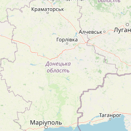
Holy Mountains National Nature Park is located within Ukraine and situated in the Donetsk Oblast region. The protected area is classified as an interior mainland park without transboundary, coastal, or marine designations.
- Countries
- Ukraine
- Regions
- Donetsk Oblast
- Primary location
- Donetsk Oblast
- Geographic setting
- Inland
Boundary and coordinates
Spatial dimensions and geographic reach across 406 square kilometers
Map and Boundary Limits of Holy Mountains National Nature Park
Interactive boundary maps trace the geographic limits and shape of Holy Mountains National Nature Park. Key spatial data points provide calculated estimates of the total protected area, central coordinates, and outer latitudinal spans.
- Boundary area
- 405.7 km²
- Boundary perimeter
- 481.9 km
- Northernmost point
- 49.1252° N
- Southernmost point
- 48.8739° N
- Easternmost point
- 38.2319° E
- Westernmost point
- 37.2952° E
- Geographic centre
- 48.9848° N, 37.7024° E
- North–south span
- 27.9 km
- East–west span
- 68.5 km
Elevation and terrain
Mixed relief profiles and recorded natural features across the protected landscape
Holy Mountains National Nature Park Terrain and Elevation Summary
Recorded elevation metrics outline the mixed terrain profile within Holy Mountains National Nature Park. Associated feature cards detail local rivers, lakes, and landforms with verified spatial relationships.
- Maximum elevation
- 130 m
Selected named natural features
Beaches
НКМЗ
Cliffs
Крейдяний обрив, що обсипався
Viewpoints
Лавочка бiля урвища
Lakes
Маяцьке озеро
Forests
Дробишевське лісництво
Environmental setting
Temperate climate zones, dominant forest cover, and mixed relief classifications
Environmental Setting and Habitat Classifications of Holy Mountains National Nature Park
Recorded landscape features and habitat types serve as complementary ways to read the physical setting of Holy Mountains National Nature Park. Stored classifications connect recorded environmental categories to relevant atlas destinations across the terrain.
- Relief
- Mixed relief
- Climate
- Temperate
- Water
- Major water bodies
- Forest cover
- Dense forest cover
- Seasonality
- Year-round
Landscape features
Mountains · Cliffs · Forest · Rivers · Lakes · Valleys · Wetland
Habitat types
Temperate broadleaf forest · Grassland · Wetland · Riverine habitat
Park atlas
Compare the diverse protected landscapes and geographical features of Donetsk Oblast and surrounding regions.
Discover Nearby National Parks and Protected Areas Beyond Holy Mountains National Nature Park
After exploring Holy Mountains National Nature Park, you can browse other protected areas within Donetsk Oblast and the broader Eastern Ukraine region. This allows for geographical comparison of diverse landscapes, from riverine forests and chalk cliffs to steppe ecosystems, enhancing your understanding of regional conservation efforts.
National parkUkraine
About 82 km away#1 closest
North

Dvorichna National Nature Park: Protected Landscape and Geographic Atlas in Ukraine
Explore mapped boundaries and regional geography within Ukraine.
Understand the protected landscape identity of Dvorichna National Nature Park, a national park situated in Ukraine. This page provides detailed geographic context, focusing on mapped protected areas and the park's natural terrain. It serves as an atlas entry point to comprehend the park's placement within Eastern Europe and its significance as a conservation landscape.
- Area
- 31.31 km²
- Established
- 2009
- IUCN
- II
- Relief
- Highland
National parkKharkiv Oblast
About 97 km away#2 closest
Northwest
Homilsha Woods National Nature Park: National Park & Protected Landscape Atlas
Ancient oak woodlands and river valley geography in Kharkiv Oblast.
Delve into the protected natural heritage of Homilsha Woods National Nature Park, a significant national park situated in Ukraine's Kharkiv Oblast. This park preserves exceptional examples of ancient oak forests, some hundreds of years old, set within a complex geographic transition zone between steppe and forest ecosystems. Its diverse terrain, including hilly uplands and riverine plains, provides a compelling subject for mapped landscape discovery and understanding regional protected area distribution.
- Area
- 143 km²
- Established
- 2004
- IUCN
- II
- Relief
- Upland

National parkDonetsk Oblast
185 km away#3 closest
South
Meotyda National Nature Park: Coastal Wetlands and Bird Migration Hub in Donetsk Oblast
Explore protected park boundaries and unique Azov Sea ecosystems.
Meotyda National Nature Park protects a critical stretch of the Sea of Azov coastline, featuring diverse habitats such as coastal wetlands, estuaries, and steppe. Located in Donetsk Oblast, this national park is internationally recognized for its importance to migratory birds, supporting millions of waterfowl and over 100 nesting bird species annually. MoriAtlas offers an in-depth view of its geographic setting, mapped protected area, and its role within regional ecological corridors, providing essential context for understanding this significant Ukrainian natural landscape.
- Area
- 207.21 km²
- Established
- 2009
- IUCN
- II
- Relief
- Lowland

National parkKharkiv Oblast
About 195 km away#4 closest
Northwest
Sloboda National Nature Park: National Park Protected Landscape in Kharkiv Oblast
Mapped Boundaries and Regional Geography Exploration
Investigate Sloboda National Nature Park, a recognized national park situated within Ukraine's Kharkiv Oblast. This page offers detailed insights into its protected landscape, focusing on its geographic setting and mapped terrain. Understand how this park contributes to the regional geography of Sloboda Ukraine and explore its mapped boundaries for a structured atlas discovery experience.
- Area
- 52.44 km²
- Established
- 2009
- IUCN
- II
- Relief
- Mixed relief

National parkSumy Oblast
About 236 km away#5 closest
Northwest
Hetman National Nature Park: National Park Geography and Protected Landscape Atlas
Mapped protected area within Sumy Oblast, Ukraine.
Explore Hetman National Nature Park, a designated national park situated in Sumy Oblast, Ukraine. This page offers a detailed look at its geographic setting, mapped boundaries, and role as a protected landscape. Understand its place within the regional geography of northeastern Ukraine and utilize MoriAtlas for structured map-based discovery of this significant natural area.
- Area
- 234 km²
- Established
- 2009
- IUCN
- II
- Relief
- Lowland
National parkZaporizhzhia Oblast
About 245 km away#6 closest
Southwest
Grand Meadow National Nature Park: National Park Protected Landscape and Regional Geography
Explore the mapped boundaries and natural terrain.
Grand Meadow National Nature Park represents a distinct protected landscape within Zaporizhzhia Oblast, Ukraine. As a national park, its designation signifies an area managed for conservation and geographic study. This entry on MoriAtlas details the park's physical presence, offering users the opportunity to explore its mapped terrain, understand its role in regional geography, and place it within the broader atlas of Ukrainian protected areas. It is ideal for users seeking concrete landscape context and precise geographic data.
- Area
- 168 km²
- Established
- 2006
- IUCN
- II
- Relief
- Lowland

National parkZaporizhzhia Oblast
About 276 km away#7 closest
Southwest
Pryazovia National Nature Park: National Park Protected Landscape Atlas
Explore the mapped boundaries and regional geography of Pryazovia National Nature Park.
Pryazovia National Nature Park represents a key protected area within Zaporizhzhia Oblast, Ukraine. This MoriAtlas entry provides detailed atlas-style information, emphasizing the park's mapped boundaries and its integration into the regional geography. Understand the park's character as a protected natural landscape situated in the southeastern Ukrainian coastal zone near the Sea of Azov, offering valuable context for geographic exploration.
- Area
- 781 km²
- Established
- 2010
- IUCN
- II
- Relief
- Lowland
National parkPoltava Oblast
About 307 km away#8 closest
West
Lower Sula National Nature Park: Protected Wetlands and River Floodplain Atlas Explorer
Mapped boundaries and geography of this Ukrainian national park.
Discover the detailed geography and protected landscape features of Lower Sula National Nature Park, located in Poltava Oblast, Ukraine. This page provides an atlas-level view of its critical wetland habitats, including marshes and shallow lakes, which are vital for waterfowl and fish spawning. Explore the park's unique position within the Sula River floodplain and its ecological significance as a national nature park, offering rich context for geographic study.
- Area
- 186 km²
- Established
- 2010
- IUCN
- II
- Relief
- Lowland
MoriAtlas Explorer
Continue Atlas Exploration of Holy Mountains National Nature Park's Geography
Deepen your understanding of Holy Mountains National Nature Park by examining its precise geographic features and protected landscape context. This detailed view within MoriAtlas allows for structured discovery of the park's boundaries and its relationship to the surrounding terrain of Donetsk Oblast, facilitating comprehensive atlas-based research.
Browse next
Global natural geography
Explore related park routes
Explore MoriAtlas Global ParksBrowse All MoriAtlas ParksGlobal Park Map DiscoveryMoriAtlas: Browse All CountriesBrowse All MoriAtlas ContinentsNational Park Environment AtlasGrand Canyon National Park AtlasYellowstone National Park AtlasYosemite National Park Atlas and GeographySerengeti National Park AtlasGalápagos National Park Protected LandscapeBanff National Park Geography and AtlasKruger National Park Atlas EntryUluṟu-Kata Tjuṯa National Park AtlasExplore Uluru-Kata Tjuta National Park GeographyPlitvice Lakes National Park AtlasFiordland National Park Protected LandscapeGreat Smoky Mountains National Park AtlasAfghanistan National Parks and Protected AreasAlbania National Parks and Protected AreasAlgeria National Parks and Protected AreasAmerican Samoa National Parks and Protected AreasAndorra National Parks and Protected AreasAngola National Parks and Protected AreasAntarctica National Parks and Protected AreasAntigua and Barbuda Park List