Mori Atlas logo
National parkHundrap-Shandur National Park

Understand the mapped boundaries and regional context of this national park in Pakistan.

Hundrap-Shandur National Park: Pakistan's Protected Landscape and National Park Geography

Hundrap-Shandur National Park stands as a significant protected area within the geographic tapestry of Pakistan. As a designated national park, it offers critical insights into the nation's natural landscapes and conservation efforts. Exploring this entity through MoriAtlas provides a clear view of its mapped boundaries, situates it within Pakistan's broader regional geography, and highlights its importance for understanding protected land distribution.

Protected areaPakistanMountain parkNational park

Hundrap-Shandur National Park

National park

Park overview

Structured park overview, official facts, and landscape profile for Hundrap-Shandur National Park

Hundrap-Shandur National Park park facts, protected area profile, and essential visitor context

Review the core facts for Hundrap-Shandur National Park, including designation, size, terrain, visitor scale, habitats, and operating context in one park-focused overview.
Protection and recognition

Reviewing official conservation frameworks and global protected area datasets for the park landscape.

Documented Protection Status and Designations of Hundrap-Shandur National Park

Explorers can examine the official boundary status, historical designation frameworks, and documented management criteria for Hundrap-Shandur National Park. Reviewing standardized geographic records provides essential context on how global authorities classify and preserve vulnerable montane habitats.

Protection details

Transboundary protection
No
Monthly climate preview

Long-term temperature ranges and precipitation rhythm across twelve recorded months

Hundrap-Shandur National Park Climate Normals and Monthly Weather Patterns

Hundrap-Shandur National Park exhibits measured monthly temperature variations spanning severe sub-zero averages alongside stable low daily precipitation rates. Examining the complete twelve-month climatological profile provides structured analytical depth for tracking regional environmental conditions.
Annual mean-3 °C
-15 °C9 °C
Jan-15°
Feb-14°
Mar-9°
Apr-3°
May
Jun
Jul
Aug
Sep
Oct-2°
Nov-8°
Dec-13°
Warmest month
July

9.1 °C

Coolest month
January

-15.5 °C

Wettest month
April

1.5 mm/day

Driest month
June

0.5 mm/day

Park location guide

Geography guide, regional context, and park location map for Hundrap-Shandur National Park

Hundrap-Shandur National Park park geography, regions, and map view in Pakistan

Understand where Hundrap-Shandur National Park sits in Pakistan through a broader geographic reading of the surrounding landscape, nearby location context, and its mapped position within the national park landscape.

How Hundrap-Shandur National Park fits into Pakistan

Pakistan, officially the Islamic Republic of Pakistan, is a federal parliamentary Islamic republic in South Asia. It is the fifth-most populous country and the 33rd-largest by area. The country gained independence from British India in 1947 and has a diverse history spanning ancient civilizations including Mehrgarh and the Indus Valley Civilisation. Pakistan shares maritime borders with Oman and is bounded by the Arabian Sea, Gulf of Oman, and several neighboring countries.

Wider geography shaping Hundrap-Shandur National Park in Pakistan

Pakistan is located in South Asia, bordered by the Arabian Sea to the south, the Gulf of Oman to the southwest, and shares land borders with India to the east, Afghanistan to the west, Iran to the southwest, and China to the northeast. The country also shares a maritime border with Oman in the Gulf of Oman. The Wakhan Corridor in Afghanistan separates Pakistan from Tajikistan in the northwest.

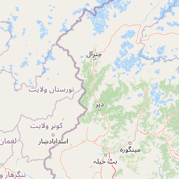
Map view of Hundrap-Shandur National Park

Use this park location map to pinpoint Hundrap-Shandur National Park in Pakistan, understand its exact geographic position, and read its mapped placement within the surrounding landscape more clearly.

Pigeon | © OpenStreetMap contributors
Park atlas

Gain regional context and compare other protected areas across the surrounding geography, expanding your view beyond Hundrap-Shandur National Park.

Explore Other National Parks and Protected Areas Near Hundrap-Shandur National Park

Browse a curated list of national parks and protected areas in Pakistan, focusing on those situated in mountainous regions near Hundrap-Shandur National Park. This structured geographic overview helps compare conservation landscapes and understand the regional distribution of protected natural areas, offering deeper insights into their contextual significance.
National parkKhyber Pakhtunkhwa
About 75 km away#1 closest

East

Manglot National Park: Protected Landscape Identity and Mapped Geography in Khyber Pakhtunkhwa

Explore its natural terrain and protected boundaries.

Manglot National Park is a designated national park offering a distinct protected landscape within the Khyber Pakhtunkhwa region. This entry focuses on its geographic setting, providing an atlas-style perspective of its mapped boundaries and the surrounding natural terrain. Understand its role as a protected area and its contribution to the regional geography, supporting detailed landscape exploration.

Area
7.11 km²
Established
1990
IUCN
II
Relief
Mixed relief
Watercolor painting depicting mountains, a river, grassy fields, and trees
National parkPakistan
About 82 km away#2 closest

West

Chitral National Park: Pakistan's Protected Alpine Wilderness and Markhor Habitat

Explore its mapped boundaries and dramatic mountain geography.

Chitral National Park, situated in Pakistan's Hindu Kush range, is a significant protected area characterized by its dramatic alpine terrain. This national park provides crucial habitat for endangered markhor and snow leopards amidst glacial valleys and cedar forests. The park's extensive elevation gradient, from 1,450 to 5,000 meters, offers a rich landscape for geographic discovery and understanding the distribution of its unique wildlife within the western Himalayas.

Area
77.5 km²
Established
1984
IUCN
II
Relief
Mountain
National parkAfghanistan
About 82 km away#3 closest

North

Wakhan National Park: Afghanistan's Protected Landscape for Geographic Atlas Exploration

Mapped boundaries and regional terrain context.

Wakhan National Park is a designated national park in Afghanistan, offering critical insights into the country's rugged, mountainous geography. This page provides an atlas-level view of its protected landscape, detailing its geographic scope and mapped boundaries. Explore Wakhan National Park to understand its role within the broader regional context of Central and South Asia's natural terrain.

Area
10,910.1 km²
Established
2014
IUCN
II
Relief
Mountain
National parkKhyber Pakhtunkhwa
About 112 km away#4 closest

Northeast

Broghil Valley National Park: High-Altitude Protected Landscape and Alpine Wilderness in Pakistan

Explore mapped terrain with glacial lakes and diverse mountain ecosystems.

Broghil Valley National Park, a national park in Pakistan's Khyber Pakhtunkhwa province, is a vast high-altitude wilderness defined by its dramatic glacial topography, numerous freshwater lakes, and vital peatland ecosystems. Situated near the Afghanistan border, this protected area offers an exceptional landscape for exploring remote mountain biodiversity and understanding the geography of Pakistan's northern frontier. Its unique terrain provides critical habitat within the Central Asian mountain range.

Area
1,348 km²
Established
2010
IUCN
II
Relief
Mountain
National parkKhyber Pakhtunkhwa
About 165 km away#5 closest

Southeast

Saiful Muluk National Park: Mapped Protected Landscape and Alpine Terrain in Pakistan

Discover the geography and protected boundaries of this Himalayan national park.

Saiful Muluk National Park in Khyber Pakhtunkhwa, Pakistan, is a key protected area characterized by its stunning alpine lake and dramatic Himalayan topography. This entry details the park's geographic scope, mapped landscape features, and its role as a critical national park. Understand the unique subalpine forests and meadow habitats that define this mountainous region and its protected status.

Area
880 km²
Established
2003
IUCN
II
Relief
Mountain
National parkPakistan
About 183 km away#6 closest

Southeast

Lulusar-Dudipatsar National Park: Pakistan's Dramatic Western Himalayan Protected Area

Explore alpine lakes, mountain scenery, and protected landscape geography.

Lulusar-Dudipatsar National Park stands as a remarkable protected landscape within Pakistan's Western Himalayas. The park's geography is defined by towering peaks and a series of pristine glacial lakes, including the iconic Dudipatsar and Lulusar lakes. Users can explore its mapped terrain and understand its significance as a high-altitude ecosystem and a key component of Pakistan's protected areas network.

Established
2003
IUCN
II
Relief
Mountain
Climate
Alpine
National parkAzad Kashmir
About 192 km away#7 closest

Southeast

Ghamot National Park: Pakistan National Park Atlas and Protected Landscape

Explore mapped boundaries and regional geography in Azad Kashmir.

Ghamot National Park represents a cornerstone for protected area exploration in Pakistan, situated within the dramatic mountainous terrain of Azad Kashmir. As a national park, it is recognized for its critical function as a wildlife corridor, especially for the survival of the Himalayan Brown Bear, and harbors diverse avian populations. This page offers detailed insight into its geographic context and its significance within a broader regional conservation strategy, providing rich data for atlas-based discovery.

Established
2004
IUCN
II
Relief
Mountain
Access
Remote access
National parkAfghanistan
About 195 km away#8 closest

Southwest

Nuristan National Park: Afghanistan National Park Protected Landscape

Mapped geography and regional terrain context

Explore Nuristan National Park, an important national park within Afghanistan. This protected area offers insights into the country's mountainous geography and its conservation landscape. Understand its mapped boundaries and its role within the broader regional context for atlas-driven discovery.

Area
5,733.07 km²
Established
2020
IUCN
II
Relief
Mountain

Common questions about visiting, size, designation, and location context for Hundrap-Shandur National Park

Hundrap-Shandur National Park FAQs for park facts, access, geography, and protected area context

Find quick answers about Hundrap-Shandur National Park, including protected-area facts, park geography, trail and visitor context, and how the park fits into its surrounding country and regional landscape.
MoriAtlas Explorer

Continue Your Protected Areas Search Across the Global Atlas

Deepen your exploration by continuing the structured search for national parks and protected areas worldwide. Utilize the comprehensive filtering capabilities to compare different conservation landscapes and refine your understanding of global park geography. Discover more about the distribution and characteristics of protected natural areas.

Global natural geography