Mori Atlas logo
National parkKawésqar National Park

Discover the geographic setting and protected landscape of Kawésqar National Park.

Kawésqar National Park: Mapped Protected Area and National Park Boundaries in Chile

(Parque Nacional Kawésqar)

Kawésqar National Park represents a significant protected national park within the vast geography of the Magallanes and Chilean Antártica Region. This page offers an atlas-style exploration focused on the park's mapped boundaries and its role as a conservation landscape. Understand the geographic context and protected area identity of Kawésqar National Park as part of your exploration of Chile's natural heritage.

Magellanic rainforestPatagonian archipelagoIndigenous heritageTemperate forest wildernessGlacial landscapesCoastal islands

Kawésqar National Park

National park

Park overview

Structured park overview, official facts, and landscape profile for Kawésqar National Park

Kawésqar National Park park facts, protected area profile, and essential visitor context

Review the core facts for Kawésqar National Park, including designation, size, terrain, visitor scale, habitats, and operating context in one park-focused overview.

About Kawésqar National Park

Kawésqar National Park represents one of the most significant protected wilderness areas in southern South America, encompassing the remote western archipelagos of Chilean Patagonia. The park's territory stretches from Canal Concepción westward to the open Pacific Ocean, crossing through the strategic waterways of the Strait of Magellan. This extensive protected area includes hundreds of islands and islets of varying sizes, all shaped by glacial processes that created the characteristic low mountain-like formations and complex coastal geometry. The landscape is defined by the interplay between land and sea, where narrow channels winds between forested islands and dramatic fjords penetrate deep into the mountainous terrain. The park's isolation has preserved relatively intact ecosystems, with the Magellanic rainforest serving as the ecological backbone that defines the park's character and supports its biodiversity. The name Kawésqar honors the indigenous people who navigated these waters and lived among these islands for thousands of years, making the park both an ecological and cultural heritage site of national importance.

Quick facts and research context for Kawésqar National Park

Kawésqar National Park occupies an area of 7,023,542 acres, making it the second largest protected area in Chile. The park extends across the western archipelagos from Canal Concepción to the Pacific Ocean, encompassing parts of both Magallanes Province and Última Esperanza Province in the Magallanes and Chilean Antártica Region. The climate is characterized by two distinct types: high humidity with mild cold conditions, and isothermal tundra, with mean temperatures ranging from 6.5°C to 7.2°C. Annual rainfall can reach up to 2,450 mm, creating the consistently damp conditions that sustain the Magellanic rainforest ecosystem. The park was established on July 22, 1969, and is administered by the Corporación Nacional Forestal.

Protection and recognition

Documenting official management scope, designation records, and regional conservation status.

Kawésqar National Park Protection Status and Conservation Designation

Official registries outline the formal boundaries, protection scope, and management frameworks established for Kawésqar National Park. Verifying official designations offers essential geographic context for understanding the conservation structures governing Patagonian wilderness areas.

Protection details

Protection scope
Mixed
Transboundary protection
No
Park context

Deeper park guide and search-rich context for Kawésqar National Park

Kawésqar National Park history, landscape, wildlife, and travel context

Explore Kawésqar National Park through its history, landscape character, ecosystems, wildlife, conservation priorities, cultural context, and seasonal travel timing in a structured park guide built for atlas discovery and search intent.

Why Kawésqar National Park stands out

Kawésqar National Park is best known for its extraordinary Magellanic rainforest ecosystem, one of the southernmost forest systems in the world. The park protects a vast archipelago of islands and islets carved by glacial activity, forming an intricate network of channels and fjords that define the Patagonian coast. Its cultural significance stems from being named in honor of the Kawésqar people, whose ancient presence on these islands dates back seven millennia. The combination of exceptional ecological diversity, with approximately 24 mammal species and numerous marine species in surrounding waters, and profound indigenous heritage makes this park a distinctive protected area within Chile's national park system.

Kawésqar National Park history and protected-area timeline

Kawésqar National Park was established on July 22, 1969, originally designated as Alacalufes National Reserve. The protected area was created to preserve the unique Patagonian ecosystems of the western archipelagos and to honor the cultural heritage of the Kawésqar people who have inhabited these islands for approximately seven thousand years. The reserve was later redesignated as a national park, reflecting its heightened conservation status within Chile's protected area network. Administration of the park falls under the Corporación Nacional Forestal (CONAF), the national forest corporation responsible for managing Chile's protected areas. The park's creation represented an important step in Chile's efforts to protect its southernmost wilderness areas, which include some of the most pristine temperate ecosystems remaining in South America.

Kawésqar National Park landscape and geographic character

The landscape of Kawésqar National Park is defined by its archipelagic character, consisting of hundreds of islands and islets scattered across a maze of channels, fjords, and sheltered bays. The islands feature low, rounded mountain-like topography shaped by glacial processes, with elevations that create a harmonious skyline against the often overcast sky. The park encompasses parts of both the Pacific coast and the Strait of Magellan, giving it a dual maritime character where ocean waters mingle with the protected strait waters. Seno Ballenas (Whale Sound) represents one of the notable marine indentations within the park. The coastal environments range from rocky shores and cliffs to pebbled beaches and marshy areas where freshwater streams meet the sea. The combination of steep island slopes, dense forest cover reaching the water's edge, and the ever-present presence of water creates a landscape of exceptional visual complexity and remoteness.

Kawésqar National Park ecosystems, habitats, and plant life

The nature of Kawésqar National Park is dominated by the Magellanic rainforest, a distinctive temperate forest ecosystem found only in the southernmost regions of South America. This forest type thrives in the cool, humid conditions created by the high annual rainfall, which can reach up to 2,450 mm per year. The forest typically features dense vegetation with multiple canopy layers, adapted to the constant moisture and limited sunlight during long winter periods. The two climate types within the park include the high humidity mild cold zone and the isothermal tundra zone, each supporting slightly different forest compositions and densities. The mean annual temperatures of 6.5°C to 7.2°C create conditions that are hostile to many plant species found elsewhere in Chile, making the Magellanic rainforest a specialized ecosystem of global significance.

Kawésqar National Park wildlife and species highlights

Kawésqar National Park supports approximately 24 different species of mammals within its terrestrial environments, reflecting the biodiversity supported by the Magellanic rainforest ecosystem. The surrounding marine waters, including the channels and fjords that penetrate the archipelago, are home to numerous marine species that depend on the productive cold waters of the southern Pacific and the Strait of Magellan. The park's position at a relatively high southern latitude places it within a unique biogeographic zone where species from both South American continental ecosystems and sub-Antarctic regions overlap. Marine mammals frequent the park's waters, utilizing the sheltered channels and bays as feeding and resting areas.

Kawésqar National Park conservation status and protection priorities

Kawésqar National Park represents a conservation priority of national and international significance due to its role in protecting one of the world's southernmost rainforest ecosystems. The Magellanic rainforest is considered a globally unique habitat type that has evolved in isolation, making it irreplaceable from a biodiversity perspective. The park's vast size ensures that ecological processes can continue with minimal human interference, maintaining natural patterns of species distribution and ecosystem function. The designation of the area as a national park, rather than a reserve, reflects Chile's commitment to长期保护 this remarkable wilderness area. The protection of the Kawésqar people's ancestral lands also embeds cultural conservation within the park's management framework.

Kawésqar National Park cultural meaning and human context

The Kawésqar people, also known as the Alacaluf, arrived in the archipelago region approximately seven thousand years ago and developed a sophisticated existence as nomadic hunter-gatherers adapted to the harsh maritime environment of southern Patagonia. Their traditional lifestyle centered on the rich marine resources of the channels and fjords, as well as the terrestrial wildlife of the islands. The park is named in honor of this indigenous group, acknowledging their deep connection to the land and waters that now fall within the protected area. The Kawésqar represent one of the southernmost indigenous cultures in the Americas, and their presence on these islands predates European contact by millennia. This cultural heritage adds a significant dimension to the park's identity beyond its ecological value.

Top sights and standout views in Kawésqar National Park

The Magellanic rainforest, the second-largest protected area in Chile, the archipelago landscape of islands and fjords, the ancient Kawésqar heritage, exceptional Patagonian wilderness, the remote Strait of Magellan region, and the network of channels and islets defining the western coast.

Best time to visit Kawésqar National Park

The optimal time to visit Kawésqar National Park is during the southern hemisphere summer months, from December through March, when temperatures are at their mildest and daylight hours are longest. During this period, visitors can experience the park's landscapes with greater clarity, as rainfall remains high throughout the year but summer typically offers more stable weather windows. The cool temperate conditions persist year-round, with temperatures rarely rising significantly above the mean of 7°C, so warm, waterproof clothing is essential regardless of the season. The long daylight hours of summer allow more time for exploration of the intricate island network, though the remote nature of the park means that access is limited and requires careful planning.

Monthly climate preview

Long-term temperature and precipitation averages across the Magallanes and Chilean Antártica Region

Kawésqar National Park Climate Averages and Weather by Month Patterns

Climatological data recorded for Kawésqar National Park indicates cool average temperatures and persistent precipitation across all twelve months. Comparing the complete twelve-month database reveals specific weather by month trends alongside detailed fluctuations in maximum and minimum temperatures.
Annual mean6 °C
3 °C9 °C
Jan
Feb
Mar
Apr
May
Jun
Jul
Aug
Sep
Oct
Nov
Dec
Warmest month
February

8.9 °C

Coolest month
July

3 °C

Wettest month
January

7.7 mm/day

Driest month
September

5.3 mm/day

Park location guide

Geography guide, regional context, and park location map for Kawésqar National Park

Kawésqar National Park park geography, regions, and map view in Chile

Understand where Kawésqar National Park sits in Chile through a broader geographic reading of the surrounding landscape, nearby location context, and its mapped position within the national park landscape.

How Kawésqar National Park fits into Chile

Chile is a presidential republic in western South America, extending as a narrow strip along the western edge of the continent between the Andes Mountains and the Pacific Ocean. It is the southernmost country in the world and the closest to Antarctica. The country is bordered by Peru, Bolivia, and Argentina, and administers several Pacific islands including Easter Island. Chile is a major copper producer and has a population of approximately 19.6 million.

Wider geography shaping Kawésqar National Park in Chile

Chile occupies a narrow strip of land along the western edge of South America, extending approximately 4,300 km north to south but only about 350 km east to west at its widest point. The country is sandwiched between the Andes Mountains to the east and the Pacific Ocean to the west. It shares borders with Peru to the north, Bolivia to the northeast, and Argentina to the east. Southern Chile borders the Drake Passage. Chile also administers several Pacific islands including Juan Fernández Islands, Isla Salas y Gómez, Desventuradas Islands, and Easter Island, plus the Chilean Antarctic Territory.

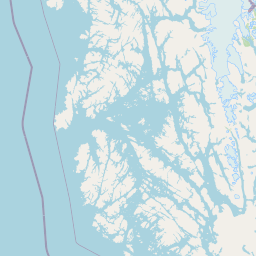
Map view of Kawésqar National Park

Use this park location map to pinpoint Kawésqar National Park in Chile, understand its exact geographic position, and read its mapped placement within the surrounding landscape more clearly.

Pigeon | © OpenStreetMap contributors

Location context for Kawésqar National Park

Magallanes and Chilean Antártica RegionMagallanes ProvinceÚltima Esperanza Province
Natural feature types

Explore the Named Natural Features and Geography of Kawésqar National Park

Browse the diverse list of islands, channels, and forests that shape the rugged landscape of Kawésqar National Park. MoriAtlas provides this structured geography to help you understand the spatial complexity and physical landmarks associated with this immense Patagonian protected area.
Recorded earthquake history

Examine Historical Seismic Data Recorded Near Kawésqar National Park

Access a structured, factual catalogue of recorded earthquakes associated with the geography of Kawésqar National Park. Use these datasets to review historical seismic events, including event magnitude and epicentre distance, to gain deeper insight into the regional activity surrounding this remote Chilean archipelago.

Kawésqar National Park Earthquake History

Catalogued events

44 events

Strongest magnitude

Magnitude 6.9

Most recent event

Apr 15, 2026

This history includes earthquakes recorded inside the park or within 50 km of its borders

Park atlas

Expand your park discovery from Kawésqar National Park to other protected landscapes and national parks across the Southern Chile archipelago.

Discover Other National Parks and Protected Areas Near Kawésqar National Park

Continue your exploration from Kawésqar National Park by browsing other national parks and protected areas across Chile's remote Patagonian archipelago. Discover how nearby conservation landscapes connect to the unique Magellanic rainforest ecosystem and vast glacial fjords, gaining broader regional geographic context.
National parkMagallanes Region
Park boundaries overlap#1 closest

Southeast

Alberto de Agostini National Park: Glacial Landscapes and Cordillera Darwin Geography

Explore a protected national park in Chile's Magallanes Region.

Alberto de Agostini National Park is a significant protected area within the Magallanes Region, defined by the dramatic southern extent of the Andes, including the iconic Cordillera Darwin. This national park is characterized by extensive tidewater glaciers, deep fjords, and unique subpolar forests, offering a profound example of glacial landscape formation. Understanding its geographic setting and mapped boundaries provides critical context for exploring this remote Patagonian wilderness and its ecological significance.

Area
14,600 km²
Established
1965
IUCN
II
Relief
Mountain
National parkAysén del General Carlos Ibáñez del Campo Region
Park boundaries overlap#2 closest

North

Bernardo O'Higgins National Park: Southern Patagonian Ice Field & Glacial Terrain

Chile's largest protected area: a map of vast ice caps and fjords.

Bernardo O'Higgins National Park is a colossal protected landscape in Chile, safeguarding much of the Southern Patagonian Ice Field and its colossal glacial features like the Pío XI Glacier. Explore the dramatic terrain of towering granite peaks and intricate fjord systems that define this remote national park. This page provides essential context for understanding its geography, mapped boundaries, and significance as a vast wilderness preservation.

Area
35,259 km²
Established
1969
IUCN
II
Visitors
36K annual
National parkMagallanes Region
27 km away#3 closest

Northeast

Torres del Paine National Park: National Park Protected Area Geography

Explore mapped protected landscapes and regional context.

Torres del Paine National Park represents a distinct protected landscape within Chile's Magallanes Region, offering valuable insights for geographic discovery and atlas exploration. This national park's mapped boundaries and unique terrain contribute to a comprehensive understanding of its protected status and environmental context. MoriAtlas provides structured data to explore the park's geography, landscape features, and its role as a vital protected natural area for detailed study.

Area
1,814.14 km²
Established
1959
IUCN
II
Visitors
304.9K annual
National parkArgentina
60 km away#4 closest

North

Los Glaciares National Park: Argentinian National Park with Patagonian Ice Fields

Explore glacial terrain and iconic Andes peaks.

Los Glaciares National Park is a vast protected area in Argentina, dominated by a massive Patagonian ice cap and numerous descending glaciers, including the renowned Perito Moreno Glacier. Its dramatic landscape of ice fields, glacial lakes, and towering granite spires like Mount Fitz Roy provides critical context for understanding regional geography and the formation of glacial terrain. This park exemplifies the unique protected ecosystems of the southern Andes, offering rich detail for atlas-based discovery.

Area
7,269.27 km²
Established
1937
IUCN
II
Visitors
688.8K annual
National parkMagallanes y la Antártica Chilena Region
73 km away#5 closest

South

Diego Ramírez Islands and Drake Passage National Park: A Southern Ocean Protected Landscape

Explore its remote island geography and vital Drake Passage marine ecosystems.

This national park protects one of the world's most remote and ecologically significant subantarctic environments, safeguarding the Diego Ramírez Islands and the legendary Drake Passage. It covers over 14 million hectares, representing Chile's southernmost contribution to global marine conservation and protecting unique pelagic bird habitats, marine mammal feeding grounds, and distinctive submarine geomorphology including Sars Seamount. The park's landscape is characterized by harsh subantarctic conditions, with vegetation adapted to cold, windy environments, and unique seafloor terrain beneath the powerful Antarctic Circumpolar Current.

Area
144,391 km²
Established
2025
IUCN
II
Climate
Subpolar
National parkTierra del Fuego
150 km away#6 closest

Southeast

Yendegaia National Park: A Chilean Protected Landscape within Tierra del Fuego

Mapped geographic context and protected area discovery.

Yendegaia National Park in Tierra del Fuego, Chile, stands as a distinct protected area offering valuable insights into regional geography and landscape. This page serves as a focused entry point for understanding the park's mapped boundaries and its significance as a national park. Delve into the specific geography and protected natural landscape that defines Yendegaia National Park within the broader South American atlas context.

Area
1,506.12 km²
Established
2013
IUCN
II
Relief
Mountain
National parkChile
166 km away#7 closest

East

Pali-Aike National Park: Chilean Protected Area and Landscape Atlas

Explore the geographic context and park boundaries in Chile.

Examine Pali-Aike National Park as a distinct protected landscape within Chile. This entry offers a detailed atlas perspective, focusing on its mapped boundaries, regional geographic setting, and the specific character of its natural terrain. Understand its significance as a national park and a point of interest for geographic discovery.

Area
50.3 km²
Established
1970
IUCN
II
Visitors
2.5K annual
Watercolor illustration of a lake with mountains and greenery under a pink-hued sky
National parkArgentina
194 km away#8 closest

Southeast

Tierra del Fuego National Park: Southernmost Argentinian National Park and Protected Landscape

Explore the mapped terrain and subantarctic geography of this vital protected area.

Tierra del Fuego National Park, located at the southern tip of South America, provides a crucial atlas perspective on subantarctic ecosystems. This protected national park encompasses dramatic glacial valleys, rugged mountain ranges, ancient beech forests, and a significant coastal area along the Beagle Channel. Its unique landscape, accessible from Ushuaia, offers rich opportunities for understanding regional geography and the distribution of protected lands at the continent's edge.

Area
630 km²
Established
1960
IUCN
II
Relief
Mountain

Common questions about visiting, size, designation, and location context for Kawésqar National Park

Kawésqar National Park FAQs for park facts, access, geography, and protected area context

Find quick answers about Kawésqar National Park, including protected-area facts, park geography, trail and visitor context, and how the park fits into its surrounding country and regional landscape.
MoriAtlas Explorer

Continue Your Protected Areas Search Across the Global Atlas

Deepen your exploration by continuing the structured search for national parks and protected areas worldwide. Utilize the comprehensive filtering capabilities to compare different conservation landscapes and refine your understanding of global park geography. Discover more about the distribution and characteristics of protected natural areas.

Global natural geography