Mori Atlas logo
National parkPali-Aike National Park

Discover the mapped boundaries and natural terrain of this unique Chilean national park.

Pali-Aike National Park: Chile's Protected Landscape and Regional Geography

Pali-Aike National Park represents a significant protected natural area within Chile's diverse geography. This page provides detailed atlas-style insights into the park's mapped boundaries and its place within the broader regional landscape. Understand the unique terrain and protected-area identity of Pali-Aike National Park as a key component of Chile's natural heritage.

Volcanic landscapesArchaeological sitesPatagoniaPrehistoric hunter sitesCave sitesEndemic species

Pali-Aike National Park

National park

Park overview

Structured park overview, official facts, and landscape profile for Pali-Aike National Park

Pali-Aike National Park park facts, protected area profile, and essential visitor context
Review the core facts for Pali-Aike National Park, including designation, size, terrain, visitor scale, habitats, and operating context in one park-focused overview.

About Pali-Aike National Park

Pali-Aike National Park sits in the heart of Chilean Patagonia, a region renowned for its extreme weather, vast open spaces, and dramatic landscapes. The protected area encompasses a portion of the Pali-Aike Volcanic Field, a geological formation that dominates the terrain with its volcanic cones, lava flows, and rocky formations. The landscape presents a stark, almost otherworldly appearance, with ancient volcanic rocks forming the backbone of the terrain. The park takes its name from the Tehuelche term Pali-Aike, meaning Desolate Place, a name that captures the windswept, rugged character of this southern landscape. Within the park boundaries, the Pali Aike Crater stands as a prominent geological landmark, a volcanic cone that has shaped both the physical environment and the human history of the region. The area has been recognized internationally for its archaeological significance, with the Pali Aike Cave and nearby Fell's Cave proposed as a joint World Heritage Site to UNESCO in 1998.

Quick facts and research context for Pali-Aike National Park

Pali-Aike National Park is located in the Magallanes and Chilean Antártica Region of Chile, approximately 150 kilometers north of Punta Arenas. The park was established on October 23, 1970, and occupies a portion of the Pali-Aike Volcanic Field, a geological formation featuring multiple volcanic cones and extensive lava flows. The area is characterized by its stark volcanic scenery, including the Pali Aike Crater that gives the park its name. Archaeological excavations at Pali Aike Cave have yielded some of the oldest human artifacts in South America, with stone tools and remains dating to around 11,000 years before present. The park receives approximately 2,500 visitors annually.

Park context

Deeper park guide and search-rich context for Pali-Aike National Park

Pali-Aike National Park history, landscape, wildlife, and travel context
Explore Pali-Aike National Park through its history, landscape character, ecosystems, wildlife, conservation priorities, cultural context, and seasonal travel timing in a structured park guide built for atlas discovery and search intent.

Why Pali-Aike National Park stands out

Pali-Aike National Park is best known for two remarkable features: its volcanic landscape of ancient lava fields and craters, and its extraordinary archaeological significance. The Pali Aike Cave contains evidence of prehistoric human occupation dating to the Paleo-Indian period, making it one of the oldest archaeological sites in South America. Stone tools recovered from the cave, including distinctive fluted fishtail projectile points, represent some of the earliest evidence of human presence in the southern cone of South America. The cave also yielded three cremated human skeletons, a rare find in archaeological contexts. Additionally, the park features petroglyphs and rock carvings created by these ancient peoples, who hunted guanaco, puma, fox, and extinct Pleistocene fauna including the mylodon and American horse.

Pali-Aike National Park history and protected-area timeline

Pali-Aike National Park was established on October 23, 1970, creating formal protection for a landscape of extraordinary geological and archaeological importance. The park's establishment recognized both the unique volcanic terrain of the Pali-Aike Volcanic Field and the remarkable archaeological discoveries made within its boundaries. The archaeological significance of the area was first recognized in the 1930s when the site was discovered and studied by American archaeologist Junius Bird, who conducted pioneering excavations at Pali Aike Cave. His work revealed the site as a temporary encampment used by Paleo-Indian hunters, yielding stone tools, human remains, and evidence of the hunting practices of these early inhabitants. The cave's stratigraphy reveals occupation layers dating from 8,600 to 11,000 years ago, making this one of the oldest archaeological sites in South America. In 1998, the Pali Aike and Fell's Caves were jointly proposed to UNESCO as World Heritage Sites, highlighting their exceptional significance in understanding early human settlement in the Americas.

Pali-Aike National Park landscape and geographic character

The landscape of Pali-Aike National Park is defined by its volcanic origins, presenting a terrain of stark beauty and geological significance. The park encompasses part of the Pali-Aike Volcanic Field, a volcanic area characterized by numerous volcanic cones, extensive lava flows, and rugged rocky formations. The most prominent feature is the Pali Aike Crater, a volcanic cone that rises from the surrounding terrain and serves as the park's namesake. The volcanic rocks throughout the park are ancient, with lava flows estimated to be around 1,000 years old, creating a landscape that feels both ancient and primordial. Rocky formations dot the terrain, their surfaces weathered by the relentless winds of Patagonia. The overall appearance is one of dramatic desolation, with dark volcanic rocks contrasting against the often grey and overcast sky of the southern Andes. The terrain is relatively flat to gently rolling, with the volcanic cones providing the primary vertical relief in this exposed landscape.

Pali-Aike National Park ecosystems, habitats, and plant life

The nature of Pali-Aike National Park reflects the harsh but ecologically important environment of southern Patagonia. The vegetation of the park consists of native flora adapted to the cold, windy conditions of this latitude. The park supports plant communities typical of the Patagonian steppe, with grasses and scrub vegetation dominating the landscape between the volcanic formations. Some plant species found within the park are exclusive to this region, representing endemic species that occur nowhere else in the world. The park's position within the Pali-Aike Volcanic Field means that the underlying geology strongly influences soil conditions and vegetation patterns, with volcanic soils supporting distinctive plant communities. The harsh climate of extreme southern Patagonia shapes all aspects of the ecosystem, with strong winds, low temperatures, and limited precipitation creating challenging conditions for plant life.

Pali-Aike National Park wildlife and species highlights

The wildlife of Pali-Aike National Park includes species typical of Patagonian ecosystems, with guanaco being one of the most commonly observed large mammals in the protected area. These wild relatives of the llama thrive in the open terrain of the park, grazing on the vegetation among the volcanic formations. The park is home to a variety of other fauna, including fox species and birds adapted to the open steppe environment. Some wildlife species found in the park are endemic to the broader Magallanes Region, meaning they occur naturally only in this part of the world. The archaeological record from Pali Aike Cave reveals that ancient human inhabitants hunted guanaco, puma, fox, and various bird and rodent species, demonstrating the ecological importance of this area for supporting wildlife over millennia. The park also provides habitat for smaller mammals that occupy the rocky outcrops and lava fields.

Pali-Aike National Park conservation status and protection priorities

Pali-Aike National Park represents an important conservation area in Chilean Patagonia, protecting both significant geological features and exceptional archaeological resources. The protected status of the area ensures the preservation of the Pali-Aike Volcanic Field's unique volcanic landscape, including the Pali Aike Crater and ancient lava formations that characterize the terrain. Beyond geological conservation, the park protects archaeological sites of global significance, with Pali Aike Cave containing evidence of some of the earliest human occupation in South America. The proposal to UNESCO in 1998 for World Heritage designation, made jointly with nearby Fell's Cave, reflects the international recognition of the site's exceptional value. The park is managed by Chile's Corporación Nacional Forestal, which is responsible for maintaining the protected area and its ecological and cultural values for future generations.

Pali-Aike National Park cultural meaning and human context

The cultural significance of Pali-Aike National Park extends far beyond its role as a protected natural area, with the archaeological discoveries within the park providing crucial insights into early human settlement in southern South America. Pali Aike Cave represents a site of exceptional archaeological importance, having been used as a temporary encampment by Paleo-Indian hunter-gatherers around 11,000 years ago. The cave's name comes from the Tehuelche language, reflecting the presence of this indigenous group in the region. The artifacts recovered from the site include stone tools with distinctive fluted fishtail points, a projectile technology associated with early hunter groups in South America. The discovery of three cremated human skeletons at the site is particularly significant, as cremation practices are rarely encountered in the prehistoric record of the Americas. These ancient inhabitants hunted a variety of Pleistocene fauna including the extinct mylodon and American horse, in addition to guanaco, puma, and fox. The use of local volcanic rocks as red pigments for ceremonial purposes has also been documented at the site.

Top sights and standout views in Pali-Aike National Park

Pali-Aike National Park offers visitors the opportunity to explore one of South America's most significant archaeological sites in a dramatic volcanic landscape. The Pali Aike Crater provides a striking geological landmark at the heart of the park, while the ancient lava flows and rocky formations create a landscape of primordial beauty. The cave system within the park contains evidence of human occupation spanning nearly three millennia, with artifacts representing some of the oldest known human presence in southern South America. Visitors can walk among volcanic formations that are approximately 1,000 years old while contemplating the lives of the prehistoric hunters who once inhabited this landscape. The presence of guanaco roaming the volcanic terrain adds wildlife viewing opportunities to the archaeological and geological attractions of the park.

Best time to visit Pali-Aike National Park

The best time to visit Pali-Aike National Park depends on the experience visitors seek, though the Patagonian summer months from December to March typically offer the most favorable conditions for exploration. During this period, temperatures are relatively milder and daylight hours are longest, allowing more time for outdoor activities and sightseeing. However, visitors should be prepared for the unpredictable weather characteristic of Patagonia, where conditions can change rapidly regardless of season. The park's location in the far south of Chile means that temperatures remain cool even during summer, and visitors should bring appropriate layered clothing for the variable conditions. The shoulder seasons of spring and autumn may offer fewer visitors but also more changeable weather. Winter visits are possible but limited by shorter daylight hours and colder temperatures.

Park location guide

Geography guide, regional context, and park location map for Pali-Aike National Park

Pali-Aike National Park park geography, regions, and map view in Chile
Understand where Pali-Aike National Park sits in Chile through a broader geographic reading of the surrounding landscape, nearby location context, and its mapped position within the national park landscape.

How Pali-Aike National Park fits into Chile

Chile is a presidential republic in western South America, extending as a narrow strip along the western edge of the continent between the Andes Mountains and the Pacific Ocean. It is the southernmost country in the world and the closest to Antarctica. The country is bordered by Peru, Bolivia, and Argentina, and administers several Pacific islands including Easter Island. Chile is a major copper producer and has a population of approximately 19.6 million.

Wider geography shaping Pali-Aike National Park in Chile

Chile occupies a narrow strip of land along the western edge of South America, extending approximately 4,300 km north to south but only about 350 km east to west at its widest point. The country is sandwiched between the Andes Mountains to the east and the Pacific Ocean to the west. It shares borders with Peru to the north, Bolivia to the northeast, and Argentina to the east. Southern Chile borders the Drake Passage. Chile also administers several Pacific islands including Juan Fernández Islands, Isla Salas y Gómez, Desventuradas Islands, and Easter Island, plus the Chilean Antarctic Territory.

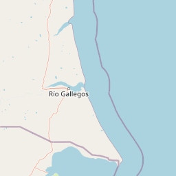
Map view of Pali-Aike National Park

Use this park location map to pinpoint Pali-Aike National Park in Chile, understand its exact geographic position, and read its mapped placement within the surrounding landscape more clearly.

Pigeon | © OpenStreetMap contributors

Location context for Pali-Aike National Park

Magallanes Region
Park atlas

Explore the broader protected-area geography of Chilean Patagonia, revealing landscapes similar to Pali-Aike National Park.

Compare Pali-Aike National Park with Nearby Protected Areas in Chilean Patagonia
After exploring Pali-Aike National Park, continue your geographic discovery by browsing other national parks and protected areas across Chilean Patagonia, comparing their volcanic terrain and archaeological significance. Trace the regional spread of conservation landscapes and mapped park geography to find your next protected area to research.
National park

Monte León National Park: Patagonia's First Continental Marine Protected Area and Coastal Atlas

Explore its unique sandstone formations and rich marine geography.

Monte León National Park stands as a significant federal protected area along Argentina's Patagonian coast. Known for its dramatic sandstone cliffs, including the iconic Monte Cabeza de León, and extensive Magellanic penguin colonies, this park offers a unique glimpse into coastal ecosystems. Its designation as Argentina's first continental marine park highlights its importance for biodiversity and landscape conservation along the southern Argentine Sea shoreline, providing rich context for atlas exploration.

Area
621.68 km²
Established
2004
IUCN
II
Relief
Upland
National parkMagallanes Region

Torres del Paine National Park: National Park Protected Area Geography

Explore mapped protected landscapes and regional context.

Torres del Paine National Park represents a distinct protected landscape within Chile's Magallanes Region, offering valuable insights for geographic discovery and atlas exploration. This national park's mapped boundaries and unique terrain contribute to a comprehensive understanding of its protected status and environmental context. MoriAtlas provides structured data to explore the park's geography, landscape features, and its role as a vital protected natural area for detailed study.

Area
1,814.14 km²
Established
1959
IUCN
II
Visitors
304.9K annual
National parkMagallanes Region

Alberto de Agostini National Park: Glacial Landscapes and Cordillera Darwin Geography

Explore a protected national park in Chile's Magallanes Region.

Alberto de Agostini National Park is a significant protected area within the Magallanes Region, defined by the dramatic southern extent of the Andes, including the iconic Cordillera Darwin. This national park is characterized by extensive tidewater glaciers, deep fjords, and unique subpolar forests, offering a profound example of glacial landscape formation. Understanding its geographic setting and mapped boundaries provides critical context for exploring this remote Patagonian wilderness and its ecological significance.

Area
14,600 km²
Established
1965
IUCN
II
Relief
Mountain
Watercolor illustration of a lake with mountains and greenery under a pink-hued sky
National park

Tierra del Fuego National Park: Southernmost Argentinian National Park and Protected Landscape

Explore the mapped terrain and subantarctic geography of this vital protected area.

Tierra del Fuego National Park, located at the southern tip of South America, provides a crucial atlas perspective on subantarctic ecosystems. This protected national park encompasses dramatic glacial valleys, rugged mountain ranges, ancient beech forests, and a significant coastal area along the Beagle Channel. Its unique landscape, accessible from Ushuaia, offers rich opportunities for understanding regional geography and the distribution of protected lands at the continent's edge.

Area
630 km²
Established
1960
IUCN
II
Relief
Mountain
National parkMagallanes and Chilean Antártica Region

Kawésqar National Park: A National Park with Distinct Protected Landscape Identity

Explore the mapped geography and protected area boundaries.

Kawésqar National Park is a key national park entity situated within the Magallanes and Chilean Antártica Region, contributing to the protected landscape of southern Chile. This atlas-focused profile details the park's geographic scope and its significance as a designated protected area. It serves as an entry point for understanding the mapped terrain and regional park context, crucial for structured geographic discovery.

Area
28,425.3 km²
Established
1969
IUCN
IV
Visitors
1.7K annual
National park

Los Glaciares National Park: Argentinian National Park with Patagonian Ice Fields

Explore glacial terrain and iconic Andes peaks.

Los Glaciares National Park is a vast protected area in Argentina, dominated by a massive Patagonian ice cap and numerous descending glaciers, including the renowned Perito Moreno Glacier. Its dramatic landscape of ice fields, glacial lakes, and towering granite spires like Mount Fitz Roy provides critical context for understanding regional geography and the formation of glacial terrain. This park exemplifies the unique protected ecosystems of the southern Andes, offering rich detail for atlas-based discovery.

Area
7,269.27 km²
Established
1937
IUCN
II
Visitors
688.8K annual
National parkAysén del General Carlos Ibáñez del Campo Region

Bernardo O'Higgins National Park: Southern Patagonian Ice Field & Glacial Terrain

Chile's largest protected area: a map of vast ice caps and fjords.

Bernardo O'Higgins National Park is a colossal protected landscape in Chile, safeguarding much of the Southern Patagonian Ice Field and its colossal glacial features like the Pío XI Glacier. Explore the dramatic terrain of towering granite peaks and intricate fjord systems that define this remote national park. This page provides essential context for understanding its geography, mapped boundaries, and significance as a vast wilderness preservation.

Area
35,259 km²
Established
1969
IUCN
II
Visitors
36K annual
National park

Perito Moreno National Park: Argentina's Expansive Patagonian Protected Landscape

Explore its mapped terrain and significant protected area geography.

Perito Moreno National Park stands as a cornerstone of Argentinian conservation, safeguarding over 126,000 hectares of striking Patagonian mountain wilderness. This national park protects a rare ecological transition zone, blending wet Andean forests with dry steppe environments across its dramatic amphitheater-like terrain and dual-watershed hydrography. Its mapped boundaries encompass significant natural geography, offering a clear atlas view of protected Patagonian landscapes.

Area
1,268.3 km²
Established
1937
IUCN
II
Relief
Mountain

Common questions about visiting, size, designation, and location context for Pali-Aike National Park

Pali-Aike National Park FAQs for park facts, access, geography, and protected area context
Find quick answers about Pali-Aike National Park, including protected-area facts, park geography, trail and visitor context, and how the park fits into its surrounding country and regional landscape.
MoriAtlas Explorer

Continue Your Protected Areas Search Across the Global Atlas

Deepen your exploration by continuing the structured search for national parks and protected areas worldwide. Utilize the comprehensive filtering capabilities to compare different conservation landscapes and refine your understanding of global park geography. Discover more about the distribution and characteristics of protected natural areas.

Global natural geography