Mori Atlas logo
National parkKhibiny National Park

Discover mapped terrain and regional geography within Murmansk Oblast's protected arctic expanse.

Khibiny National Park: Russia's Arctic National Park and Protected Landscape

(National Park Khibiny)

Khibiny National Park stands as a significant protected natural area within the Murmansk Oblast of northwestern Russia. This national park offers a unique lens through which to explore the mapped landscapes and regional geography of the Kola Peninsula. As part of the MoriAtlas geographic discovery platform, Khibiny National Park provides critical context for understanding arctic protected lands and their place within the broader atlas of natural features. Users can delve into the park's protected boundaries and its distinctive terrain.

Subarctic landscapesMountain protected areasTaiga ecosystemsNorthern RussiaAlpine tundraVolcanic mountains

Khibiny National Park

National park

Park overview

Structured park overview, official facts, and landscape profile for Khibiny National Park

Khibiny National Park park facts, protected area profile, and essential visitor context
Review the core facts for Khibiny National Park, including designation, size, terrain, visitor scale, habitats, and operating context in one park-focused overview.

About Khibiny National Park

Khibiny National Park is a relatively young protected area established in 2018 in the far northwestern reaches of Russia, on the Kola Peninsula in Murmansk Oblast. The park encompasses the dramatic Khibiny Mountains and the adjacent Lovozero Massif, creating a protected corridor around a mountainous region that rises abruptly from surrounding low plains. The terrain is characterized by a circular mountain range approximately 40 kilometers across, with the park divided into two roughly equal sectors on either side of a central valley corridor that remains outside the protected zone. Lake Imandra forms the western boundary of the park, while Lake Umbozero marks its eastern edge. The park's establishment reflects ongoing efforts to preserve the ecological integrity of this geographically significant region while managing the competing demands of industrial mining, which has historical roots in the area, and recreational use by hikers and skiers. The park is administered by FGBU Khibiny and was incorporated into the Lapland State Biosphere Reserve in 2019, strengthening its conservation framework.

Quick facts and research context for Khibiny National Park

Khibiny National Park spans 84,804 hectares in Murmansk Oblast, northwestern Russia, protecting the mountainous Khibiny Mountains and Lovozero Massif. The park features elevations ranging from 130 to 1,196 meters and is divided into west and east sectors of approximately equal size. Located near the cities of Kirovsk and Olenegorsk, the park sits at the northern edge of the taiga ecoregion, very close to the tundra zone. The area experiences a subarctic climate with brief summers and cold, snowy winters.

Park context

Deeper park guide and search-rich context for Khibiny National Park

Khibiny National Park history, landscape, wildlife, and travel context
Explore Khibiny National Park through its history, landscape character, ecosystems, wildlife, conservation priorities, cultural context, and seasonal travel timing in a structured park guide built for atlas discovery and search intent.

Why Khibiny National Park stands out

Khibiny National Park is best known for its unique position at the ecological boundary where northern taiga transitions to Arctic tundra, creating a complex mosaic of habitats within a relatively compact mountain landscape. The park protects the distinctive Khibiny Mountains, a circular range of ancient volcanic origin that contains commercially important mineral deposits. Its ecological significance stems from the mixing of species from both Arctic and boreal zones across multiple altitude zones, resulting in higher species diversity than typical for this latitude. The park also represents a rare example of balancing industrial mining interests with nature protection and recreational use within a protected area framework.

Khibiny National Park history and protected-area timeline

Khibiny National Park was officially established on February 8, 2018, representing a significant addition to Russia's network of protected areas. The park's creation came as part of broader efforts to consolidate and strengthen environmental protection in the Murmansk Oblast region. In April 2019, the park was merged into the Lapland State Biosphere Reserve, a larger conservation and sustainable development framework that coordinates protection efforts across a wider geographic area. This integration reflects the ecological connectivity between the Khibiny Mountains and the surrounding tundra and taiga landscapes that extend across the western Kola Peninsula. The park exists within a region with a long history of human activity, including mining operations that have extracted valuable minerals from the mountains for decades. The boundaries of the protected area were designed to balance three primary uses: conservation of the unique natural environment, recreation including summer hiking and winter skiing, and the ongoing industrial mining activities that have shaped the region's economy.

Khibiny National Park landscape and geographic character

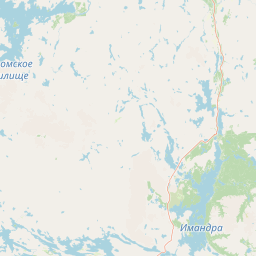
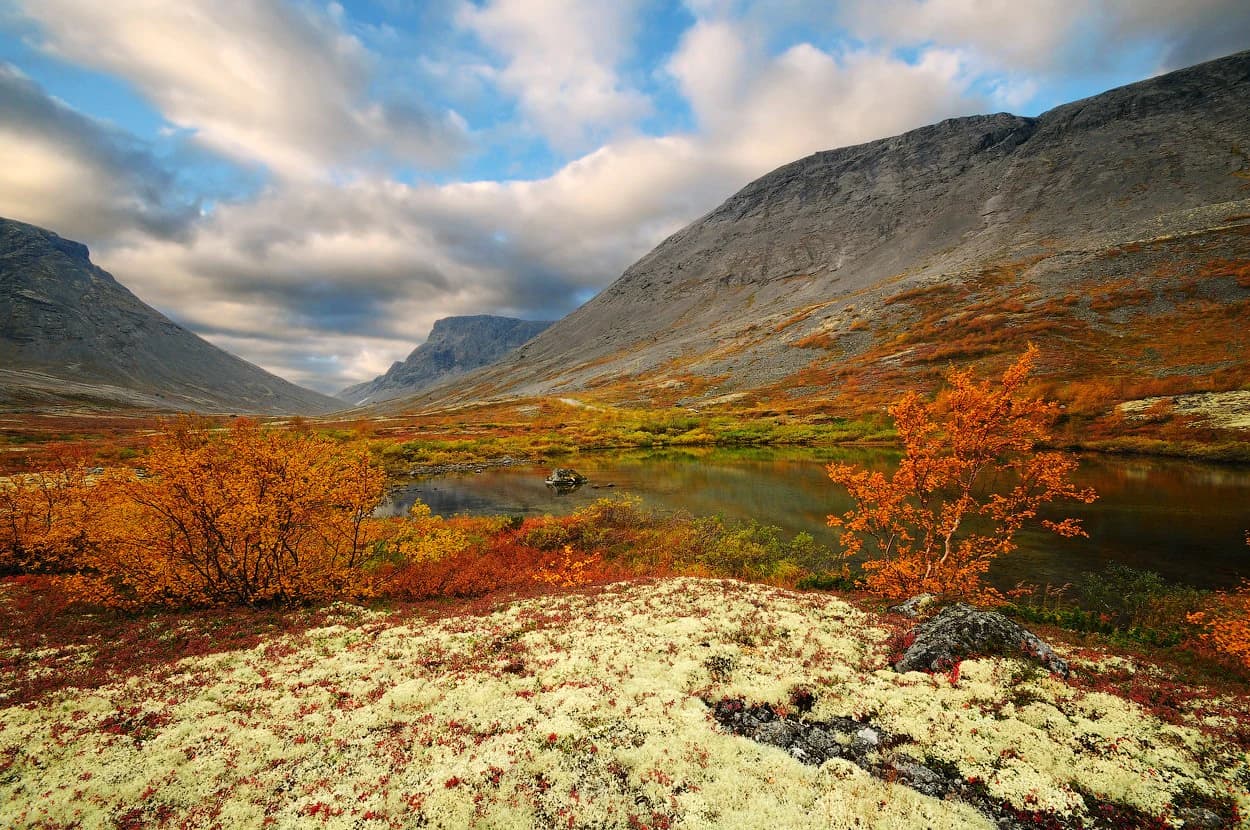
The Khibiny Mountains form the core of the park's dramatic landscape. This ancient volcanic mountain range rises sharply from the surrounding low plains, creating a distinctive circular massif approximately 40 kilometers in diameter. The terrain is varied and complex, with rocky peaks, steep slopes, and numerous valleys carved by glacial and erosion processes. Elevations within the park range from 130 meters at the lowest points to 1,196 meters at the highest peaks. The two main sectors of the park, western and eastern, are separated by a central valley corridor that provides access to the mountain interior. Lake Imandra, a large northern lake, borders the park to the west, while Lake Umbozero lies along the eastern boundary. This combination of mountainous terrain, valley systems, and large lake bodies creates a diverse scenic landscape. The 8% bare rock coverage reflects the exposed mountain summits and cliff faces that characterize the higher elevations, while the 62% grassland and 27% forest coverage indicate the vegetation patterns across the lower slopes and valleys.

Khibiny National Park ecosystems, habitats, and plant life

The ecological character of Khibiny National Park is defined by its position at the boundary between two major ecoregions. The park sits at the northern edge of the Scandinavian and Russian taiga, one of the world's largest forest biomes, while being only a few kilometers south of the transition to Kola Peninsula tundra. This transitional position creates a complex ecological mosaic where species from both boreal and Arctic environments intermingle. The park's varied topography, with elevations spanning over 1,000 meters, adds further ecological complexity by creating distinct altitudinal zones. Each zone supports different plant communities, from lowland forest through subalpine vegetation to alpine tundra on the highest summits. The ground cover composition reflects this diversity: approximately 62% grassland, 27% forest, 8% bare rock exposed at higher elevations, and 3% shrub cover or water. The mixing of Arctic and taiga flora zones in this relatively compact area results in species diversity that is notably high for a subarctic location.

Khibiny National Park wildlife and species highlights

The wildlife of Khibiny National Park reflects its transitional position between Arctic and boreal ecosystems. The mixing of species from these two major ecological zones, combined with the varied terrain and multiple habitat types created by the elevation range, supports a diverse fauna community. The different altitude zones provide suitable habitats for species adapted to various conditions, from valley-bottom forests to alpine tundra. The grassland-dominant ground cover creates extensive open habitats that support different wildlife communities than would be found in fully forested areas. The proximity to Lake Imandra and Lake Umbozero adds aquatic and wetland habitats to the diversity of environments within and adjacent to the park. While specific species details are limited in the source material, the park's ecological complexity and position at a biogeographic boundary suggest the presence of both characteristic taiga species and tundra-adapted forms.

Khibiny National Park conservation status and protection priorities

Khibiny National Park represents an important conservation designation in northwestern Russia's protected area network. The park was established with the formal classification of IUCN Category II, reflecting its status as a national park with primary conservation objectives. The protection framework acknowledges the ecological significance of this transitional zone where taiga meets tundra, preserving habitats and species that would be vulnerable without formal protection. The integration of the park into the Lapland State Biosphere Reserve in 2019 strengthened the conservation context by connecting the Khibiny protection to a larger regional framework focused on sustainable development and ecosystem preservation. The park's boundary design reflects the practical challenge of balancing conservation with ongoing industrial mining activities and recreational use, demonstrating a management approach that seeks to maintain ecological integrity while accommodating multiple land uses.

Khibiny National Park cultural meaning and human context

Khibiny National Park is situated in the Murmansk Oblast region of northwestern Russia, an area with a history of human settlement and economic activity that predates the modern protected area. The Khibiny Mountains have long been known for their mineral wealth, and mining has been an important economic activity in the region around the cities of Kirovsk and Olenegorsk. The park exists within a landscape where industrial development and natural preservation coexist in ongoing tension. Local communities have traditionally used the surrounding lands for various purposes, and the recreational use of the mountains for hiking and skiing reflects a more recent but established relationship with the landscape. The Lovozero Massif, included within the park boundaries, is associated with the indigenous Sami peoples of the Kola Peninsula, though specific cultural heritage details would require additional sources.

Top sights and standout views in Khibiny National Park

The Khibiny Mountains themselves stand as the park's most distinctive feature, a dramatic volcanic range rising abruptly from the surrounding low plains. The park's ecological significance is concentrated in its transitional character, where northern taiga ecosystems blend with Arctic tundra in a relatively compact area, creating unusual biodiversity. The elevation range from 130 to 1,196 meters supports multiple distinct habitat zones within a relatively small geographic footprint. The presence of major lakes along the park's boundaries adds scenic and ecological value. The relatively recent establishment of the park in 2018 and its subsequent integration into the Lapland Biosphere Reserve represent important milestones in regional conservation.

Best time to visit Khibiny National Park

The subarctic climate of Khibiny National Park strongly influences the best season for visitation. Short, mild summers with only one to three months above 10°C offer the most comfortable conditions for hiking and outdoor exploration. The summer months provide access to the mountain trails and the opportunity to observe the brief but vibrant subarctic growing season. Winter brings cold, snowy conditions typical of subarctic regions, with the coldest months experiencing temperatures well below freezing. For winter recreation, the ski facilities around Kirovsk make the cold season attractive for skiing and snow-related activities. The park's high latitude means that summer days are very long while winter brings extended darkness, factors that affect visitor planning. The shoulder seasons of late spring and early autumn offer transitional conditions that may appeal to those seeking fewer crowds and unique atmospheric qualities.

Park location guide

Geography guide, regional context, and park location map for Khibiny National Park

Khibiny National Park park geography, regions, and map view in Russia
Understand where Khibiny National Park sits in Russia through a broader geographic reading of the surrounding landscape, nearby location context, and its mapped position within the national park landscape.

How Khibiny National Park fits into Russia

Russia is a transcontinental nation spanning eleven time zones, bordered by fourteen countries. It is the world's largest country by area, covering 17,098,246 km². Moscow is the capital and largest city, while Saint Petersburg is the second-largest and a major cultural centre.

Wider geography shaping Khibiny National Park in Russia

Russia spans Eastern Europe and North Asia, covering 17,098,246 km². It shares land borders with fourteen countries, more than any other nation, and spans eleven time zones. The landscape includes vast plains, mountain ranges such as the Urals and Caucasus, and extensive coastlines along the Arctic Ocean, Pacific Ocean, Baltic Sea, Black Sea, and Caspian Sea.

Map view of Khibiny National Park

Use this park location map to pinpoint Khibiny National Park in Russia, understand its exact geographic position, and read its mapped placement within the surrounding landscape more clearly.

Pigeon | © OpenStreetMap contributors

Location context for Khibiny National Park

Murmansk Oblast
Park atlas

Explore more protected landscapes and mountain ecosystems across the Kola Peninsula and beyond.

Discover Other National Parks and Protected Areas Near Khibiny National Park
After exploring Khibiny National Park, browse other national parks and protected areas across the northern taiga and Arctic tundra landscapes of the Kola Peninsula. Compare diverse mountain protected areas and transitional subarctic ecosystems, highlighting distinct conservation efforts and unique geographic characteristics in Northern Russia.
Watercolor illustration of a landscape with lake, trees, and hills
National parkRepublic of Karelia

Paanajärvi National Park: Republic of Karelia's Premier Protected Landscape

Explore mapped boundaries and regional geography of this national park.

This MoriAtlas entry details Paanajärvi National Park, a significant protected area situated in the Republic of Karelia. Delve into its specific geographic profile, understand its mapped protected boundaries, and see how it fits into the wider atlas of Russia's natural and protected landscapes. It serves as a dedicated point for focused discovery of this national park's unique landscape context.

Area
1,043.71 km²
Established
1992
IUCN
II
Relief
Highland
National parkLapland

Salla National Park: Mapped Protected Landscape in Lapland, Finland

Explore its geographic context and protected area identity.

Understand Salla National Park as a distinct protected landscape situated within the expansive northern Finnish region of Lapland. This MoriAtlas entry focuses on its identity as a national park, detailing its mapped boundaries and geographic setting. Discover how Salla National Park contributes to the atlas of protected areas, offering a specific point of reference for exploring the natural terrain and regional geography of this subarctic territory.

Area
99.83 km²
Established
2022
IUCN
II
Visitors
55.9K annual
National parkLapland

Oulanka National Park: Protected Landscape Atlas and Geographic Context in Lapland

Explore mapped boundaries and regional terrain.

Discover Oulanka National Park as a distinct protected landscape entity within the extensive northern region of Lapland, Finland. This page provides structured geographic information, focusing on the park's mapped area, its regional setting, and its identity as a national park. MoriAtlas facilitates an atlas-driven understanding of Oulanka National Park's place in Finland's protected lands and its inherent natural terrain.

Area
270 km²
Established
1956
IUCN
II
Visitors
187.4K annual
National parkLapland

Urho Kekkonen National Park: Detailed Map and Protected Landscape Exploration in Lapland

Discover Finland's expansive Arctic wilderness and fell terrain.

Urho Kekkonen National Park represents a significant portion of Finland's protected Arctic landscape, offering a rich opportunity for geographic and atlas-based discovery. This national park in Lapland showcases dramatic fell formations, boreal forests, and extensive wetlands, with mapped boundaries that define its wild eastern reaches and more accessible western trails. Users can explore the unique terrain and understand its place within the broader regional geography, appreciating the vastness of this protected natural area.

Area
2,550 km²
Established
1983
IUCN
II
Visitors
435.9K annual
National park

Øvre Pasvik National Park: Norway's Pristine Siberian Taiga & Mapped Boreal Geography

Explore ancient forests, wetlands, and transboundary protected landscapes.

Øvre Pasvik National Park is a landmark protected area in Northern Norway, showcasing a remarkably intact Siberian taiga ecosystem characterized by ancient Scots pine forests and extensive wetlands. This national park offers a unique geographic perspective with its notably flat terrain, distinguishing it within the broader Norwegian atlas. As part of the Pasvik, Inari Trilateral Park, it highlights significant transboundary conservation efforts and provides a valuable mapped resource for understanding European boreal landscapes and their unique wildlife habitats.

Area
119 km²
Established
1970
IUCN
II
Relief
Lowland
National parkLapland

Riisitunturi National Park: Explore Protected Landscape and Lapland Geography

Mapped boundaries of a national park in northern Finland.

Delve into the protected landscape of Riisitunturi National Park, a key national park situated in the expansive region of Lapland, Finland. This MoriAtlas entry provides detailed geographic context, focusing on the park's mapped boundaries and its role within the natural terrain of northern Finland. Understand its identity as a protected area and its significance within a broader atlas of natural landscapes.

Area
77 km²
Established
1982
IUCN
II
Visitors
58.8K annual
Watercolor illustration showing a lake, rolling hills, and vegetation.
National parkLapland

Pyhä-Luosto National Park: Ancient Geological Heritage and Fell Landscape

Explore Lapland's southernmost large fell system and deep gorges.

Pyhä-Luosto National Park offers a unique window into Finland's deep geological past and its boreal ecosystems. As a protected area, it encompasses a prominent chain of twelve fells composed of two-billion-year-old quartzite, showcasing the southernmost large fell system in the country. The park's landscape is further defined by features like Isokuru, Finland's deepest gorge, and extensive old-growth forests, providing rich context for map-based discovery and regional geographic understanding within Lapland.

Area
142 km²
Established
2005
IUCN
II
Visitors
198.9K annual
National parkFinland

Hossa National Park: Detailed National Park and Protected Landscape Geography

Explore mapped boundaries and regional context within Finland.

Delve into the protected landscape of Hossa National Park, a designated national park in Finland. This page provides structured geographic information, focusing on its mapped boundaries and position within the country's natural terrain. Understand how Hossa National Park contributes to the atlas of protected areas in Northern Europe, offering insights into its specific landscape character and regional significance for geographic discovery.

Established
2017
Scope
Terrestrial

Common questions about visiting, size, designation, and location context for Khibiny National Park

Khibiny National Park FAQs for park facts, access, geography, and protected area context
Find quick answers about Khibiny National Park, including protected-area facts, park geography, trail and visitor context, and how the park fits into its surrounding country and regional landscape.
MoriAtlas Explorer

Continue Your Protected Areas Search Across the Global Atlas

Deepen your exploration by continuing the structured search for national parks and protected areas worldwide. Utilize the comprehensive filtering capabilities to compare different conservation landscapes and refine your understanding of global park geography. Discover more about the distribution and characteristics of protected natural areas.

Global natural geography