Mori Atlas logo
National parkKislovodsk National Park

Discover the mapped boundaries and regional landscape of this significant national park.

Kislovodsk National Park: Russia's Protected Landscape Identity and Geographic Context

Kislovodsk National Park stands as a distinct protected area within the Russian Federation, offering a unique focal point for geographic discovery. This page provides an in-depth look at the park's identity as a national park, detailing its mapped landscape and its place within the regional geography. Utilize MoriAtlas to understand the protected territory and its natural context, moving beyond basic location data to a structured view of this significant natural entity.

Urban parkCaucasus foothillsMountain landscapeMineral springsEuropean parkRussian national park

Kislovodsk National Park

National park

Park overview

Structured park overview, official facts, and landscape profile for Kislovodsk National Park

Kislovodsk National Park park facts, protected area profile, and essential visitor context
Review the core facts for Kislovodsk National Park, including designation, size, terrain, visitor scale, habitats, and operating context in one park-focused overview.

About Kislovodsk National Park

Kislovodsk National Park occupies a remarkable geographic position where the Pontic-Caspian steppe meets the Caucasus Mountains, creating a transitional ecosystem of exceptional diversity. The park extends approximately five kilometers from the Kislovodsk city center up the southeastern slopes of the Dzhinal Ridge, incorporating both developed recreational areas and relatively natural forest environments. The lower park section contains extensive public spaces, gardens, and the central promenade originally planted in 1827, while the middle and upper sections offer progressively wilder terrain with hiking trails, exercise facilities, and memorial gardens. The park's significance extends beyond recreation; it preserves the ecological integrity of a mountain foothill ecosystem while providing environmental education opportunities and regulating tourism to ensure sustainable use. The combination of accessible urban recreation infrastructure with mountain trails and wilderness viewing opportunities makes this park uniquely valuable among European protected areas.

Quick facts and research context for Kislovodsk National Park

Kislovodsk National Park covers 966 hectares in Stavropol Krai, Russia, established in 2016 as the largest urban park in Europe. The park sits at the southern edge of the Pontic-Caspian steppe ecoregion, transitioning into Caucasus mixed forests at higher elevations. It features the Dzhinal Ridge with peaks Bolshoye and Maloye Saddle, the Olkhovka River along its southern boundary, and the extensive Pervomayskaya glade capable of accommodating over 100,000 visitors. The climate is subarctic with mild summers and cold, snowy winters. The park contains over 250 documented tree and shrub species including pine, beech, hornbeam, ash, maple, alder, larch, and spruce.

Park context

Deeper park guide and search-rich context for Kislovodsk National Park

Kislovodsk National Park history, landscape, wildlife, and travel context
Explore Kislovodsk National Park through its history, landscape character, ecosystems, wildlife, conservation priorities, cultural context, and seasonal travel timing in a structured park guide built for atlas discovery and search intent.

Why Kislovodsk National Park stands out

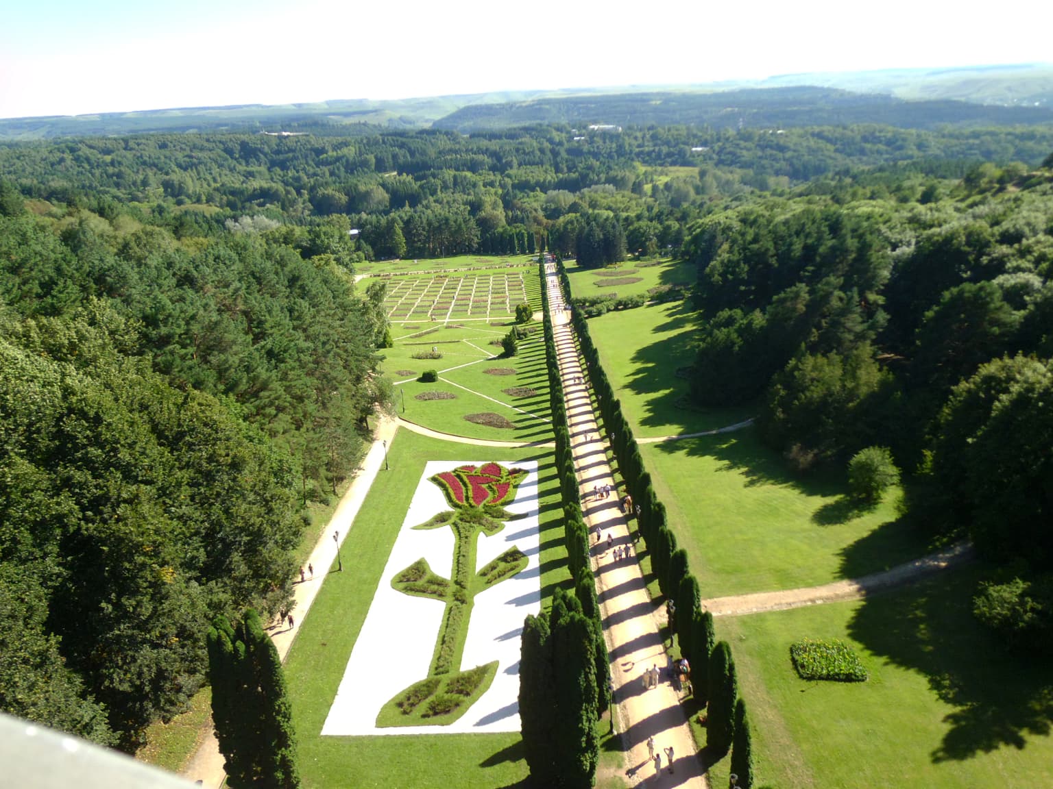
Kislovodsk National Park is best known for its extraordinary scale as Europe's largest urban park, combining resort-town recreation with mountain wilderness. The park is famous for its mineral spring heritage, with a drinking gallery where visitors can sample three distinct therapeutic waters. Its dramatic setting at the foothills of the Caucasus provides sweeping views of Mount Elbrus and the main mountain ridge from hilltop observation decks. The park's cable car ascending to the Dzhinal Ridge, the Valley of the Roses, and the seamless blend of formal gardens near the city with wilder forest at higher elevations define its distinctive character.

Kislovodsk National Park history and protected-area timeline

The history of Kislovodsk National Park is intertwined with the development of the resort town itself. The city of Kislovodsk was founded in 1803 as a military fort to protect visitors traveling to the famed medicinal springs that had drawn people to the area for centuries. The park's origins date to 1827 when soldiers planted the original promenade of Linden trees along what would become the park's central axis. Over the following decades, the area developed into an increasingly elaborate garden and promenade landscape, becoming a signature element of the resort town's identity. The urban park remained under various forms of local protection and management through the Soviet and post-Soviet periods. In 2016, following broader reforms to Russia's protected area system, the urban park was elevated to national park status with the official designation of IUCN Category II. The formal protection objectives encompass preserving the natural environment, maintaining historical and cultural sites, supporting environmental education, and managing tourism and recreational use.

Kislovodsk National Park landscape and geographic character

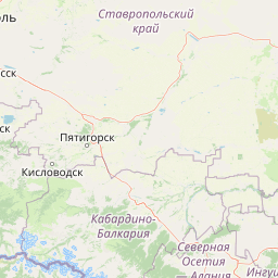
The landscape of Kislovodsk National Park is defined by its position along the Dzhinal Ridge, a foothills system of the Caucasus Mountains. The terrain rises from the city streets at around 600 meters elevation up to 1,541 meters at the ridge's highest points. The lower elevation areas feature the Pervomayskaya glade, a vast open space originally designed for public gatherings and events, capable of hosting more than 100,000 people. The park is bordered to the south by the Olkhovka River, which follows the valley floor. The surrounding topography includes Pine Hill and the Spurs of the Dzhinal Ridge, with the distinctive peaks of Bolshoye and Maloye Saddle marking the high points. From the observation decks on these ridge peaks, visitors are rewarded with distant views of Mount Elbrus, the highest mountain in Europe, and the sweeping main ridge of the Caucasus Mountains stretching along the southern horizon.

Kislovodsk National Park ecosystems, habitats, and plant life

The ecological character of Kislovodsk National Park reflects its position in a transition zone between two major ecoregions. The park sits at the extreme southern edge of the Pontic-Caspian steppe, though the steppe environment has been largely modified by centuries of human use in the lower elevations. At higher elevations and extending southward, the Caucasus mixed forests dominate, and the park incorporates elements of this richer forest type. The diversity of habitats supports an impressive array of plant life, with more than 250 species of trees and shrubs documented within the park boundaries. The vegetation patterns shift with elevation, from the more formal gardens and planted areas near the city to increasingly natural forest communities as the terrain rises. Species present include conifers such as pine, larch, and spruce alongside deciduous species including beech, hornbeam, ash, maple, and alder. This botanical diversity forms the foundation for the park's ecological significance.

Kislovodsk National Park wildlife and species highlights

While the Wikipedia source focuses primarily on botanical features, the park's location at the Caucasus foothills transition zone suggests wildlife diversity tied to the mixed forest and mountain habitats. The diverse tree and shrub communities, ranging from managed gardens to natural forest, would support various bird species, small mammals, and the characteristic fauna of the Caucasus region. The elevation gradient from steppe margins to mountain forest creates ecological niches that typically support distinct communities at different elevations. The protected status and proximity to the broader Caucasus mountain system suggest the park plays a role in maintaining ecological connectivity for species moving between lowland and alpine zones.

Kislovodsk National Park conservation status and protection priorities

Kislovodsk National Park was established in 2016 with specific conservation objectives that extend beyond typical urban park management. The national park designation provides formal protection for the natural environment while allowing for sustainable recreational use. The park preserves elements of the Pontic-Caspian steppe and Caucasus mixed forest transition zone, representing an ecological interface of significant scientific and conservation interest. Beyond natural habitat preservation, the national park status aims to protect historical and cultural elements within the landscape, support environmental education programs, and regulate tourism to ensure visitor impact remains sustainable. The elevation to IUCN Category II reflects international recognition of the park's conservation value, particularly for maintaining the ecological character of this mountain foothill landscape within a heavily used resort region.

Kislovodsk National Park cultural meaning and human context

The cultural context of Kislovodsk National Park is deeply connected to the spa resort tradition that has defined the city since the early 19th century. The park emerged from the same historical process that created Kislovodsk itself, which was established in 1803 as a military fort protecting visitors to the medicinal mineral springs that have drawn health-seeking visitors to the area for generations. The original 1827 Linden tree promenade represents one of the earliest landscape interventions, transforming the natural foothill terrain into a structured recreational landscape. This tradition of designed public space within a natural mountain setting defines the park's cultural identity. The presence of the drinking gallery, where visitors sample the mineral waters that made the town famous, connects the park directly to the therapeutic traditions that shaped the entire region.

Top sights and standout views in Kislovodsk National Park

The highlights of Kislovodsk National Park include its unique status as Europe's largest urban park, combining resort-town accessibility with mountain wilderness. The cable car ascending the Dzhinal Ridge provides effortless access to panoramic viewpoints overlooking Mount Elbrus and the Caucasus main ridge. The Valley of the Roses offers a distinctive horticultural feature, while the drinking gallery provides direct engagement with the mineral spring heritage that defined the resort town. The extensive network of hiking paths, observation decks, and public gardens creates multiple visitor experiences from formal promenade recreation to natural forest exploration. The Pervomayskaya glade represents an extraordinary public gathering space, one of the largest of its kind in any European park.

Best time to visit Kislovodsk National Park

Kislovodsk's climate of 300 annual sunshine days makes it a year-round destination, though the subarctic climate with cold, snowy winters and mild summers shapes the visitor experience. Summer months offer the most comfortable conditions for hiking the ridge trails and enjoying the outdoor recreation facilities, with warm but not extreme temperatures typical of the foothill environment. The spring and autumn seasons provide transitional weather with distinct character, fall foliage in the mixed forests offering particularly scenic conditions. Winter transforms the park into a snowy landscape suitable for those who enjoy winter recreation, though the higher elevation trails may be less accessible. The resort town's extended sunshine and the park's diverse terrain support meaningful visits across seasons, each offering different landscape characteristics.

Park location guide

Geography guide, regional context, and park location map for Kislovodsk National Park

Kislovodsk National Park park geography, regions, and map view in Russia
Understand where Kislovodsk National Park sits in Russia through a broader geographic reading of the surrounding landscape, nearby location context, and its mapped position within the national park landscape.

How Kislovodsk National Park fits into Russia

Russia is a transcontinental nation spanning eleven time zones, bordered by fourteen countries. It is the world's largest country by area, covering 17,098,246 km². Moscow is the capital and largest city, while Saint Petersburg is the second-largest and a major cultural centre.

Wider geography shaping Kislovodsk National Park in Russia

Russia spans Eastern Europe and North Asia, covering 17,098,246 km². It shares land borders with fourteen countries, more than any other nation, and spans eleven time zones. The landscape includes vast plains, mountain ranges such as the Urals and Caucasus, and extensive coastlines along the Arctic Ocean, Pacific Ocean, Baltic Sea, Black Sea, and Caspian Sea.

Map view of Kislovodsk National Park

Use this park location map to pinpoint Kislovodsk National Park in Russia, understand its exact geographic position, and read its mapped placement within the surrounding landscape more clearly.

Pigeon | © OpenStreetMap contributors

Location context for Kislovodsk National Park

Stavropol Krai
Park atlas

Trace the regional spread of protected landscapes, compare unique mountain and urban park ecosystems.

Explore National Parks and Protected Areas in the Caucasus Foothills Near Kislovodsk National Park
Browse an atlas of national parks and protected areas adjacent to Kislovodsk National Park, extending your discovery into the unique Caucasus foothills and regional geography. Compare diverse protected landscapes and mountain ecosystems across Russia, gaining valuable geographic context for your park exploration.
Watercolor painting of mountains, lake, and forest landscape with greenery and distant peaks
National parkKabardino-Balkaria

Prielbrusye National Park: Mapped Protected Landscape within Kabardino-Balkaria's Geography

Explore regional park boundaries and natural terrain context.

Prielbrusye National Park is a significant protected area featured in the MoriAtlas geographic discovery platform. This page details its identity as a national park, emphasizing its mapped boundaries and its position within the broader landscape of Kabardino-Balkaria. Users can explore the park's unique geographic context, understand its protected status, and integrate its information into a larger atlas-based understanding of regional natural territories.

Area
10,102 km²
Established
1986
IUCN
II
Relief
Mountain
Watercolor painting depicting mountains, a winding river, and green forests in a mountainous landscape
Nature reserveKarachay-Cherkess Republic

Teberda Nature Reserve: Protected Area Mapping and Geographic Context

Explore the mapped boundaries and regional geography of this protected landscape.

Teberda Nature Reserve is a significant protected area located in the Karachay-Cherkess Republic, offering rich opportunities for geographic exploration. This page provides detailed atlas-style information, focusing on the reserve's mapped landscape and its protected-area identity. Understand the unique geographic context and contours of Teberda Nature Reserve, contributing to a structured understanding of Russia's natural protected lands.

Area
849.96 km²
Established
1936
IUCN
Ia
Visitors
200K annual
National parkNorth Ossetia-Alania

Alaniya National Park: Protected Glacial Mountain Landscape in North Ossetia-Alania, Russia

Explore dramatic terrain and ancient heritage.

Alaniya National Park, situated in the rugged Central Caucasus Mountains of North Ossetia-Alania, Russia, is a premier example of a protected landscape defined by its dramatic glacial formations and high alpine environments. The park's geography features extensive glaciated peaks, deep valleys, and unique biodiversity. It preserves critical habitats and showcases significant archaeological sites, providing a rich context for understanding the natural and cultural history of the region through a structured atlas perspective.

Area
549 km²
Established
1998
IUCN
II
Relief
Mountain
National parkMtskheta-Mtianeti

Kazbegi National Park: Georgia's Alpine Protected Landscape & Regional Geography

Explore its dramatic terrain and protected area boundaries.

Kazbegi National Park offers a unique glimpse into the dramatic alpine geography of the Greater Caucasus. As a protected national park in the Mtskheta-Mtianeti region, it showcases rugged terrain, high-altitude ecosystems, and significant natural features. MoriAtlas provides a structured way to understand the park's physical characteristics, its mapped presence, and its place within the broader regional atlas, highlighting the distinct landscape of this Georgian protected area.

Area
1,446.17 km²
Established
1976
IUCN
II
Relief
Mountain
National parkGeorgia

Kolkheti National Park: Mapped Wetland Landscape & Protected Area in Georgia

Explore the peat bogs, coastal ecosystems, and bird migration routes.

Discover Kolkheti National Park, a key protected national park located in Georgia's western coastal region. This atlas entry focuses on the park's extensive wetland environments, including its significant peat bogs and Lake Paliastomi, highlighting its role as a critical migratory bird corridor and a unique natural landscape within the Black Sea region. Understand its geographic context and protected area boundaries.

Area
807.99 km²
Established
1998
IUCN
II
Visitors
13.7K annual
National parkGeorgia

Borjomi-Kharagauli National Park: Protected Landscape Atlas of Georgia's Lesser Caucasus

Explore its unique forests, wildlife, and mountain terrain.

Delve into Borjomi-Kharagauli National Park, a significant protected area in Georgia's Lesser Caucasus region. This national park is renowned for its extensive old-growth forests, including rare Colchian fragments, and a remarkable concentration of endemic species. The park's dramatic mountainous terrain, spanning over 1,000 square kilometers, offers a rich tapestry of landscapes from deep valleys to alpine meadows, providing critical habitat for large mammals and contributing significantly to the region's biodiversity. Explore its mapped boundaries and geographic context for a deeper understanding of this vital conservation landscape.

Area
1,093 km²
Established
1995
IUCN
II
Relief
Mountain
Watercolor painting showing a landscape with green hills, trees, and distant mountains
National parkMtskheta-Mtianeti

Pshav-Khevsureti National Park: Protected Mountain Landscape and Regional Geography in Mtskheta-Mtianeti

Explore rugged terrain and alpine ecosystems in Georgia's Caucasus.

Pshav-Khevsureti National Park is a key protected area in Georgia's Mtskheta-Mtianeti region, recognized for its dramatic mountain terrain, deep river valleys, and alpine zones. Established as a national park, it safeguards the watersheds of major rivers, supporting significant wildlife and offering a compelling geographic context for atlas exploration. This protected landscape provides insight into the unique natural and cultural heritage of the Khevsureti region, making it a focal point for understanding Georgia's protected area network and mountainous geography.

Area
1,400.44 km²
Established
2014
IUCN
II
Relief
Mountain
Watercolor illustration of a landscape with rolling hills, forests, and a winding river.
National parkAdjara

Kintrishi National Park: Protected Colchic Forest Canyon Landscape in Adjara

Explore the mapped geographic boundaries of this unique Georgian national park.

Kintrishi National Park, located in Georgia's Adjara region, is a protected landscape renowned for its exceptionally intact Colchic deciduous forests within a steep river gorge. This area showcases dense woodland, dramatic terrain, and the unique Colchican willow species, offering rich geographic context. As a key protected area, Kintrishi National Park provides a valuable focus for atlas-based exploration of southwestern Georgia's natural heritage.

Area
186.84 km²
Established
2007
IUCN
II
Scope
Terrestrial

Common questions about visiting, size, designation, and location context for Kislovodsk National Park

Kislovodsk National Park FAQs for park facts, access, geography, and protected area context
Find quick answers about Kislovodsk National Park, including protected-area facts, park geography, trail and visitor context, and how the park fits into its surrounding country and regional landscape.
MoriAtlas Explorer

Continue Your Protected Areas Search Across the Global Atlas

Deepen your exploration by continuing the structured search for national parks and protected areas worldwide. Utilize the comprehensive filtering capabilities to compare different conservation landscapes and refine your understanding of global park geography. Discover more about the distribution and characteristics of protected natural areas.

Global natural geography