
Mori Atlas logo
Protected areaKolland en Overlangbroek

A historic Dutch landscape defined by groundwater seepage and rare bryophyte woodland communities.

Kolland en Overlangbroek Protected Area: Mapping the Ash Floodplain Forest and Estates

Kolland en Overlangbroek represents a significant protected area within the Netherlands, showcasing the intricate relationship between the Utrechtse Heuvelrug ridge and the Kromme Rijn basin. This compact landscape preserves rare alluvial ash forests and historic estate grounds, sustained by unique groundwater seepage patterns. Explore the geography of this managed woodland, where centuries of coppice tradition support a vital community of moisture-loving mosses and liverworts within a complex riverine mosaic.

Natura 2000ash floodplain forestalluvial woodlandash coppiceestate landscapebryophytes
A graphic illustration depicting a tall waterfall cascading down colorful, angular mountain slopes with evergreen trees in the foreground and a pale sun in the sky.

Kolland en Overlangbroek

Protected area

Park overview

Structured park overview, official facts, and landscape profile for Kolland en Overlangbroek

Kolland en Overlangbroek park facts, protected area profile, and essential visitor context

Review the core facts for Kolland en Overlangbroek, including designation, size, terrain, visitor scale, habitats, and operating context in one park-focused overview.

About Kolland en Overlangbroek

Kolland en Overlangbroek is a small but ecologically rich protected area in the Dutch river landscape. It sits in the Kromme Rijn valley between the historic town of Wijk bij Duurstede and the forested ridge of the Utrechtse Heuvelrug, on the edge of the province of Utrecht near the Gelderland border. Despite its modest size of about 110 hectares, the site is recognized as one of the most valuable fragments of ash floodplain forest still present in the Netherlands.

The area is made up of two separate estates, Landgoed Kolland and Landgoed Overlangbroek, which together include the sub-areas Kolland itself, Oud Kolland, and Overlangbroek. They form part of a long-standing cultural landscape shaped by coppice management, fruit orchards, and country estates. The largest contiguous forest block, around 50 hectares, lies within Overlangbroek, while Kolland contains the easternmost parcel. The land is actively managed by the national forestry service Staatsbosbeheer, which looks after the Overlangbroek and Oud Kolland parcels, and by the private Landgoed Kolland NV, which is responsible for the Kolland parcel.

The ecological character of the site is closely tied to its hydrology. Rainwater that infiltrates into the sandy soils of the Utrechtse Heuvelrug travels underground westward and surfaces as seepage in the area. At the same time, the higher water level of the nearby Rhine creates additional upward seepage pressure into the low-lying parcels. Together these processes maintain the wet, moderately nutrient-rich, and slightly alkaline soil conditions required by the Vogelkers-Essenbos habitat. The European ash (Fraxinus excelsior) is the dominant and ecologically defining tree species, and its bark creates the basic substrate on which the area's nationally important moss communities depend.

Beyond its ecological value, Kolland en Overlangbroek is also a place of cultural heritage. The estate landscape includes planted woodlands, meadows, remnant orchards, and characteristic country houses along former sandy river ridges. Although the original economic purpose of ash coppice largely disappeared after 1960, volunteers and conservation organizations still maintain surviving stands, preserving the link between historic land use and today's conservation priorities.

Quick facts and research context for Kolland en Overlangbroek

Kolland en Overlangbroek is a Dutch Natura 2000 site composed of two adjoining estates near Wijk bij Duurstede in the province of Utrecht, just south of the Utrechtse Heuvelrug. It totals roughly 110 hectares, with the largest contiguous block, about 50 hectares, located in Overlangbroek. The site is classified as the Alluvial Bird Cherry-Ash Forest habitat (H91E0C), based on vegetation surveys carried out in 2013, and was formally designated under the European Habitats Directive in 2015. Management is split between Staatsbosbeheer and the private Landgoed Kolland NV, and the landscape reflects centuries of estate management, ash coppice, and river floodplain dynamics along the Kromme Rijn.

Protection and recognition

Terrestrial conservation history, designation year, and recognition scope

Kolland en Overlangbroek Protection Status and Designated Area Records

Kolland en Overlangbroek holds a terrestrial protection designation established in 2015 for regional conservation value. Documented administrative records track the official status and management parameters governing this protected area.

Protection details

Protection scope
Terrestrial
Designated year
2015
Transboundary protection
No
Park context

Deeper park guide and search-rich context for Kolland en Overlangbroek

Kolland en Overlangbroek history, landscape, wildlife, and travel context

Explore Kolland en Overlangbroek through its history, landscape character, ecosystems, wildlife, conservation priorities, cultural context, and seasonal travel timing in a structured park guide built for atlas discovery and search intent.

Why Kolland en Overlangbroek stands out

Kolland en Overlangbroek is especially known for one of the rarest forest types in the Netherlands: the Alluvial Bird Cherry-Ash Forest, known locally as Vogelkers-Essenbos, a moisture-loving, base-rich woodland that depends on continuous groundwater seepage. The area is also celebrated for its exceptional moss and liverwort flora. Base-loving epiphytes such as large ribbon mosses and Metzgeria and Radula liverworts grow on the basic bark of ash trees, and centuries of coppice management have created a cyclically renewed microclimate that supports this fragile community.
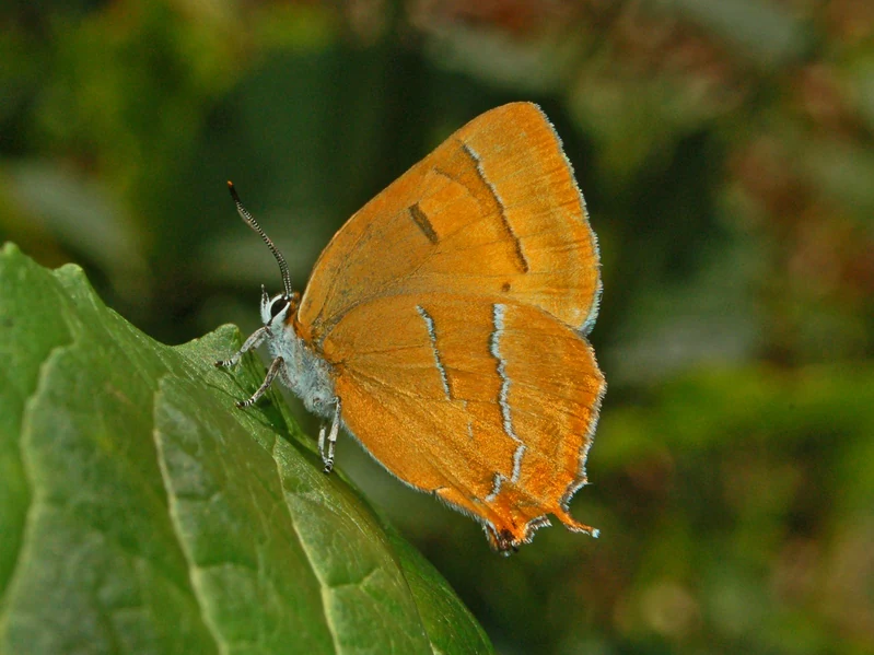
Side profile of a vibrant orange butterfly with thin white markings on its wings perched on a large green leaf.
A brown hairstreak butterfly resting on a green leaf in Kolland en Overlangbroek.

Kolland en Overlangbroek history and protected-area timeline

The landscape of Kolland en Overlangbroek began taking shape in Roman times, when regular flooding of the Kromme Rijn produced a distinctive pattern of sandy natural levees along the river and silty backswamps further inland. In the lowest areas, where water stood longest, peat formed over the clay, creating the clay-on-peat soils that still characterize parts of the region today. Over the centuries, however, these soils were heavily altered by human intervention.

Around 1000 CE the bed of the Kromme Rijn began silting up, which disrupted drainage. In 1122 a dam was constructed on the Rhine distributary near Wijk bij Duurstede, further reducing flood events and changing the hydrology of the surrounding land. As medieval villages such as Cothen and Werkhoven were established, the broader area was reclaimed and cultivated. The Langbroeker Wetering was created to drain the basin and prevent further formation of clay over peat soils.

In the early modern period, the land shifted increasingly from cropland to grassland, and new forests were planted in the form of tall woodland, ash coppice, alder coppice, oak coppice, and willow beds. Around the 18th century many country estates and manor houses were built on the higher sandy levees, giving the area its characteristic estate character. The Kolland estate originally operated as a productive enterprise focused on oak and ash coppice and orchards; today the orchards have largely been replaced by grassland, and the coppice has been converted to mature oak woodland.

Since 1960 the economic demand for ash coppice wood has collapsed, and surviving parcels are now kept alive mainly by volunteers and conservation organizations rather than by traditional commercial use. After habitat surveys in 2013 confirmed the presence of the Alluvial Bird Cherry-Ash Forest type, the site received formal Natura 2000 status in 2015 under the European Habitats Directive, focusing on the protection of threatened non-avian species, especially rare mosses and liverworts.

Kolland en Overlangbroek landscape and geographic character

The landscape of Kolland en Overlangbroek is a classic example of a small-scale Dutch river floodplain estate area. It lies in the lower part of the Kromme Rijn basin, a former distributary of the Rhine, and shows the layered mosaic of soils that developed over centuries of seasonal flooding.

Along the former river course are sandy levees, slightly higher and drier than the surrounding land, on which the 18th-century country houses and avenues were built. Behind these levees lie the lower, more silty and peaty backswamps, where the wet woodland has survived. Today the area still alternates between large blocks of forest, remnant orchards that have largely given way to grassland, and a network of ditches and small streams that drain into the Amerongerwetering and Langbroekerwetering.

To the east, the land rises toward the wooded push moraine of the Utrechtse Heuvelrug, which forms a clear natural boundary. Westward, the land opens into the broader Rhine floodplain. This compressed geography, with sand ridges, wet basins, estate avenues, and ash woodland all within a few hundred hectares, is what gives Kolland en Overlangbroek its distinctive aesthetic character, even though it is much smaller and less dramatic than many of the country's better-known national parks.
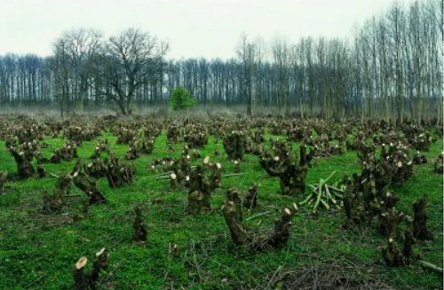
A landscape view of a field filled with many short, freshly pollarded or coppiced tree stumps, with a line of taller trees in the background.
Coppiced ash trees in the Kolland en Overlangbroek area.

Kolland en Overlangbroek ecosystems, habitats, and plant life

The defining ecological character of Kolland en Overlangbroek is its base-rich, moisture-loving ash floodplain forest. The habitat type Vogelkers-Essenbos is a variant of the European Alluvial Forests with Alnus glutinosa and Fraxinus excelsior, adapted here to sites fed by mineral-rich seepage rather than by active flooding. Its continuity depends on a stable supply of basic groundwater reaching the rooting zone of the trees, which is precisely the condition created by the combination of seepage from the Utrechtse Heuvelrug and seepage pressure from the Rhine.

The area's vegetation structure is layered. The upper canopy is dominated by European ash (Fraxinus excelsior), with alder, oak, elm, and willow also present. Beneath this, a moist understorey thrives where groundwater seepage keeps the soil wet and base-rich. In early spring, before the ash leaves emerge, the forest floor can be dominated by lesser celandine (Ficaria verna subsp. verna), while characteristic moisture-loving herbs such as garlic mustard (Alliaria petiolata) and cow parsley (Anthriscus sylvestris) appear later in the season. Wood melick (Melica uniflora), another indicator species of this habitat, is also present in the understorey.

The habitat is intrinsically linked to a centuries-old cycle of coppice management. Periodic cutting of ash regrowth created a cyclically renewed mosaic of young shoots, mature trunks, and decadent stool regrowth, each at a different stage of bark chemistry and humidity. This coppice dynamic, though currently suspended due to ash dieback, is considered essential to the long-term survival of the moss flora that depends on this unique forest type.

Kolland en Overlangbroek wildlife and species highlights

Although Kolland en Overlangbroek is primarily valued for its woodland and bryophyte communities, it also supports a varied fauna. Roe deer (Capreolus capreolus) are present across the estate and are one of the most appealing larger species for visitors, though their browsing pressure has some impact on young plantings.

The birdlife changes clearly with the seasons. In summer, warblers and other small woodland birds such as the common chiffchaff (Phylloscopus collybita), blackcap (Sylvia atricapilla), and garden warbler (Sylvia borin) breed in the dense canopy and shrub layer. In winter, the same woodland complex offers critical shelter to flocks of Eurasian woodcock (Scolopax rusticola), which gather here in large numbers during cold months.

Lepidoptera are also noteworthy. The brown hairstreak (Thecla betulae) occurs within the estate and is listed on the Dutch and Flemish red lists, making its presence here exceptional given that the species is declining across much of its European range due to loss of suitable woodland edge habitat.

Invasive species form an ongoing ecological concern. Japanese knotweed (Fallopia japonica), one of the world's most aggressive invasive plants, has established within the area and continues to spread, competing with native flora and altering the woodland edge communities.

Kolland en Overlangbroek conservation status and protection priorities

Kolland en Overlangbroek has been a Natura 2000 site since 2015, designated under the European Habitats Directive specifically to protect the Alluvial Bird Cherry-Ash Forest habitat (H91E0C) and a set of rare non-avian species, particularly mosses and liverworts that depend on the base-rich bark of ash trees. These bryophytes, including species such as Homalia trichomanoides, Neckera complanata, Metzgeria furcata, and Radula complanata, are largely restricted to this kind of habitat in the Netherlands and are the principal reason for the site's formal designation.

Conservation management has two main pillars: the management of ash and moss communities, and the protection of hydrology. The site is currently facing a major threat from ash dieback, a disease caused by the fungus Chalara fraxinea (Hymenoscyphus fraxineus), which is killing mature branches and the regrowth on coppice stools across Europe. This dieback is a serious concern because the loss of ash reduces the available basic bark substrate for the moss community and thins the canopy, lowering humidity and destabilizing the microclimate the mosses require. Compounding this, nitrogen deposition encourages acid-loving mosses that outcompete the base-loving species the site is meant to protect.

To respond to these threats, managers are pursuing a layered strategy. Dead or dying ash trees are being replaced with resilient native species such as lime and willow, alongside resistant ash genotypes, but only with species that retain basic bark chemistry so that the bryophyte community can continue. Periodic coppice cutting has been paused while ash dieback continues, but limited experimental coppice management and replanting are being piloted. On the hydrological side, a 2017 water-level decision raised permissible water levels by around 25 centimeters, allowing higher groundwater tables in the forest so that tree roots can still reach the base-rich seepage. Ditches and small gullies are also being made shallower to reduce the loss of clean seepage water and to limit mixing with nutrient-rich agricultural runoff from adjacent farmland.

Kolland en Overlangbroek cultural meaning and human context

The area embodies a recognizable Dutch estate landscape, with country houses, avenues, meadows, and woodland blocks that reflect more than a thousand years of organized land management. In the medieval period, villages such as Cothen and Werkhoven emerged as the surrounding land was reclaimed, and the construction of the Langbroeker Wetering helped shape the drainage of the basin.

From the 18th century onward, wealthy families built country estates along the slightly higher sandy levees of the former river, defining much of the area's visual character today. Landgoed Kolland itself combined productive forestry based on ash and oak coppice with orchards and meadows, a typical pattern for Dutch estates of its era. Although the economic purpose of most of these traditional land uses has faded, the underlying spatial pattern of woodlots, meadows, avenues, and manor grounds is still very much intact and is one of the reasons the area is valued not only ecologically but also as a piece of living Dutch landscape heritage.

Top sights and standout views in Kolland en Overlangbroek

Kolland en Overlangbroek stands out for combining an exceptionally rare forest habitat with one of the country's most important bryophyte communities in an estate landscape that has been managed for centuries. The site preserves a nationally significant fragment of ash floodplain forest, sustained by a unique combination of sandy upland seepage and Rhine-derived groundwater seepage that few other Dutch forests can match.

Its other defining quality is the rare base-loving moss flora that grows on ash bark, a community that depends on the centuries-old coppice dynamic and the integrity of the site's hydrology. Together with its cultural-historical estate character and its role as a refuge for woodland birds, roe deer, and threatened butterflies, the area offers a remarkably dense ecological and cultural story within a very compact footprint.

Best time to visit Kolland en Overlangbroek

Spring is one of the most rewarding times to experience Kolland en Overlangbroek. As the ash canopy is slow to leaf out, the forest floor is briefly illuminated, and early-flowering species such as lesser celandine create a striking carpet of yellow across the wet woodland, while moisture-loving herbs begin to emerge in the understorey.

Summer brings the full activity of breeding woodland birds and butterflies along the edges, with the leafy canopy creating the closed, humid microclimate that defines the ash forest habitat. In winter, the open character of the estate makes woodcock and other woodland birds easier to observe, and the bare branches reveal the structure of coppice stools that is central to the area's ecological story. Because the site is a working nature area protected under Natura 2000, visitors generally access it on marked estate paths rather than through the forest interior, and the seasonal character of the landscape is best appreciated on foot from these routes.
Monthly climate preview

Long-term representative monthly temperature averages and precipitation distribution rhythms

Kolland en Overlangbroek Climate Normals, Annual Temperature and Precipitation Patterns

Kolland en Overlangbroek records measured monthly mean temperatures ranging from 2.11 degrees Celsius to 18.12 degrees Celsius alongside consistent year-round precipitation rates. Examining the full twelve-month profile reveals complete long-term meteorological distributions across the representative coordinate.
Annual mean10 °C
2 °C18 °C
Jan
Feb
Mar
Apr
May13°
Jun16°
Jul18°
Aug18°
Sep15°
Oct10°
Nov
Dec
Warmest month
July

18.1 °C

Coolest month
January

2.1 °C

Wettest month
December

2.6 mm/day

Driest month
April

1.4 mm/day

Park location guide

Geography guide, regional context, and park location map for Kolland en Overlangbroek

Kolland en Overlangbroek park geography, regions, and map view in Netherlands

Understand where Kolland en Overlangbroek sits in Netherlands through a broader geographic reading of the surrounding landscape, nearby location context, and its mapped position within the national park landscape.

How Kolland en Overlangbroek fits into Netherlands

The Netherlands is a low-lying coastal country in Northwestern Europe, famous for its extensive dike and canal systems that reclaim land from the sea. It consists of twelve provinces and is known for tulips, windmills, and cycling culture. The country is a founding member of the European Union with Amsterdam as its capital and The Hague as the seat of government.

Wider geography shaping Kolland en Overlangbroek in Netherlands

The Netherlands is located in Northwestern Europe along the North Sea coastline to the north and west. It borders Germany to the east and Belgium to the south. The country is notably flat, with a significant portion of its territory lying below sea level, protected by dikes and dune systems. It consists of twelve provinces and also includes overseas municipalities in the Caribbean.

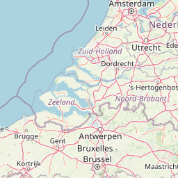
Map view of Kolland en Overlangbroek

Use this park location map to pinpoint Kolland en Overlangbroek in Netherlands, understand its exact geographic position, and read its mapped placement within the surrounding landscape more clearly.

Pigeon | © OpenStreetMap contributors

Visualizing the alluvial floodplain forests and estate habitats of the Kromme Rijn valley

Kolland en Overlangbroek Photos and Landscape Scenery Exploration

Examine detailed visual records of Kolland en Overlangbroek to study the rare ash coppice woodlands, sandy river ridges, and moisture-loving moss habitats of this Dutch protected area. Photographic documentation reveals the distinct terrain, estate character, and groundwater-fed ecosystems that define the regional landscape.

Side profile of a vibrant orange butterfly with thin white markings on its wings perched on a large green leaf.

A wide shot of a grassy meadow with patches of shrubs and trees under a cloudy sky.

A landscape view of a field filled with many short, freshly pollarded or coppiced tree stumps, with a line of taller trees in the background.

Park atlas

Compare adjacent river basin reserves and regional conservation areas.

Parks Near Kolland en Overlangbroek and Surrounding Protected Landscapes

Browse protected areas sharing similar lowland geography, alluvial woodland habitats, and regional river valley traits near Kolland en Overlangbroek. Discover adjacent conservation landscapes to expand regional park comparison and study connected wetland ecosystems.
Watercolor landscape showing green hills, forests, and a small stream with grassy patches
National parkUtrecht Province
About 6 km away#1 closest

Northeast

Utrechtse Heuvelrug National Park: Mapped Protected Landscape and Geographic Atlas

Discover Utrecht Province's glacial ridge and diverse natural terrain.

Utrechtse Heuvelrug National Park is a significant protected natural area located in Utrecht Province, renowned for its unique glacial ridge topography. This entry provides detailed information about its mapped boundaries, diverse landscapes including heathlands and forests, and its importance as an ecological corridor within the Netherlands. Explore the park's distinct geography and its role in regional conservation through our structured atlas view.

Area
100 km²
Established
2003
IUCN
II
Visitors
1M annual
A watercolor painting showing a soft, idyllic landscape with rolling hills in the background, a winding path or stream in the middle ground, and grasses and trees in the foreground.
Nature reserveGelderland
About 14 km away#2 closest

East

Binnenveld Nature Reserve: Protected Wetland and Meadowland in Gelderland

Rare blue grasslands and stream valley quaking bogs

Located in the Gelderse Vallei, Binnenveld stands as a vital nature reserve representing the complex history of Dutch polder landscapes. The area combines traditional meadowland with strictly protected habitats like the Bennekomse Meent, serving as a haven for meadow birds and an important site for ecological restoration and wetland preservation.

Area
1.11 km²
Established
2014
Relief
Lowland
Climate
Temperate
Protected areaNetherlands
About 20 km away#3 closest

Northeast

Veluwe: A Comprehensive Geographic Atlas of the Central Netherlands Protected Area

Glacial moraines, heathlands, and inland sand systems

Investigate the Veluwe, a premier protected area in the Gelderland province characterized by its historic push moraines and extensive ecological zones. The region encompasses significant sand drift complexes, dense woodlands, and vital spring-fed streams, offering a clear view of the diverse natural terrain found throughout the central Netherlands.

Area
1,000 km²
Relief
Upland
Climate
Temperate
Access
Easy access
Nature reserveGelderland
About 24 km away#4 closest

Southwest

Lingegebied & Diefdijk-Zuid: Protected Nature Reserve in Central Netherlands

A fragmented river landscape spanning three provinces

Lingegebied & Diefdijk-Zuid is a designated Natura 2000 nature reserve characterized by its scattered parcels of protected land. The area is deeply integrated into the Dutch river landscape, following the path of the Linge river and the historic Diefdijk. Its unique geography across four municipalities showcases the complex relationship between regional water management and protected European habitat types.

Area
7.5 km²
Established
2013
Relief
Lowland
Climate
Temperate
Nature reserveNetherlands
About 27 km away#5 closest

North

Arkemheen Nature Reserve: Geography and Protected Landscape Context in the Netherlands

Mapping medieval polder patterns and wetland bird habitats.

Arkemheen is a significant nature reserve in the Netherlands characterized by a flat, open polder landscape and historic fourteenth-century agricultural patterns. The area offers a distinct ecological profile, integrating freshwater border lakes with saline-influenced grasslands that support an internationally recognized population of meadow and wetland birds.

Area
14.3 km²
Established
1356
Relief
Lowland
Climate
Temperate
A horizontal watercolor painting of a winding river flowing through a lush, green countryside with soft trees and a pale, pastel-colored sky.
Nature reserveGelderland
About 27 km away#6 closest

Southwest

Loevestein, Pompveld & Kornsche Boezem: Regional Geography and Protected Area Mapping

A composite Natura 2000 network in the central Dutch river delta.

Spanning the Bommelerwaard and Land van Heusden en Altena, Loevestein, Pompveld & Kornsche Boezem represents a vital approach to protecting fragmented lowland habitats. This record provides geographic insight into the diverse riverine mosaic of floodplains, wet grasslands, and historical stream channels that define this protected landscape in the heart of the Netherlands.

Area
7.5 km²
Established
2013
Watercolor painting of rolling hills, green trees, and a winding path
National parkGelderland
About 30 km away#7 closest

East

De Hoge Veluwe National Park: Mapped Protected Landscape & Geographic Atlas Context

Explore Gelderland's unique heathland, sand dune, and woodland terrain.

De Hoge Veluwe National Park represents a distinctive protected area within the Gelderland region of the Netherlands. Its landscape is characterized by a unique mosaic of heathlands, sand dunes, and woodlands, shaped by ice age processes and historical land use. This page offers an atlas-focused exploration of its geographic setting, mapped boundaries, and the specific terrain that defines this significant natural and cultural heritage site.

Area
55 km²
Established
1935
IUCN
II
Visitors
629.4K annual
Nature reserveFlevoland
About 34 km away#8 closest

North

Eemmeer & Gooimeer Zuidoever: Mapped Geography and Protected Lake-Fringe Landscape

A Natura 2000 wetland reserve within the Flevoland region

The Eemmeer & Gooimeer Zuidoever nature reserve consists of two distinct yet interconnected lake basins that represent the evolving landscape of the central Netherlands. The area is defined by its shallow water fringes and marshy shorelines, which provide essential sanctuary for waterbirds. By tracing the boundary between engineered polders and older mainland provinces, this reserve provides a unique look at the ecological significance of the former Zuiderzee remnants.

Area
15.84 km²
Established
2009
Relief
Lowland
Climate
Temperate

Common questions about visiting, size, designation, and location context for Kolland en Overlangbroek

Kolland en Overlangbroek FAQs for park facts, access, geography, and protected area context

Find quick answers about Kolland en Overlangbroek, including protected-area facts, park geography, trail and visitor context, and how the park fits into its surrounding country and regional landscape.
MoriAtlas Explorer

Continue Your Protected Areas Search Across the Global Atlas

Deepen your exploration by continuing the structured search for national parks and protected areas worldwide. Utilize the comprehensive filtering capabilities to compare different conservation landscapes and refine your understanding of global park geography. Discover more about the distribution and characteristics of protected natural areas.

Global natural geography